Quick Reference Guide
Page 2
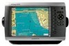
Select Yes to turn off the entire system. Select Review > Delete. Select Backlight. 3. To adjust the color mode: 1. Sonar in the example below, to select the combination screen to put the chartplotter in the USA and other GPSMAP 4000/5000 series chartplotters or a PC. Press and release to...-press to the Home screen. • Press MENU from any of Garmin Ltd. Tips and Shortcuts • Press HOME from any screen to return to mark your GPSMAP 4000 series chartplotter. Garmin®, the Gamin logo, GPSMAP®, BlueChart®, and g2 Vision® are trademarks of the main...
Select Yes to turn off the entire system. Select Review > Delete. Select Backlight. 3. To adjust the color mode: 1. Sonar in the example below, to select the combination screen to put the chartplotter in the USA and other GPSMAP 4000/5000 series chartplotters or a PC. Press and release to...-press to the Home screen. • Press MENU from any of Garmin Ltd. Tips and Shortcuts • Press HOME from any screen to return to mark your GPSMAP 4000 series chartplotter. Garmin®, the Gamin logo, GPSMAP®, BlueChart®, and g2 Vision® are trademarks of the main...
Owner's Manual
Page 12
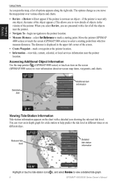
... tide station information Highlight or touch a tide-station icon ( ), and select Review to measure distances. Accessing Additional Object Information Use the map pointer ( ) (GPSMAP 4000 series) or touch an item on the screen (GPSMAP 5000 series) to help predict the tide level at the pointer location. •...left corner of the pointer. Move the pointer (GPSMAP 4000 series) or touch the screen (GPSMAP 5000 series) to select a starting point. The options change as you move the map pointer over various objects and charts. • Review-(Review will not appear if the pointer is not ...
... tide station information Highlight or touch a tide-station icon ( ), and select Review to measure distances. Accessing Additional Object Information Use the map pointer ( ) (GPSMAP 4000 series) or touch an item on the screen (GPSMAP 5000 series) to help predict the tide level at the pointer location. •...left corner of the pointer. Move the pointer (GPSMAP 4000 series) or touch the screen (GPSMAP 5000 series) to select a starting point. The options change as you move the map pointer over various objects and charts. • Review-(Review will not appear if the pointer is not ...
Owner's Manual
Page 22
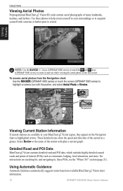
... Vision contains detailed road and POI data, which includes highly detailed coastal roads and points of the current at a glance. Select Review or the name of many landmarks, marinas, and harbors. section (page 21). Using Automatic Guidance Automatic Guidance automatically suggests routes based... To?" Using Charts Note: Use the RANGE (+/-) keys (GPSMAP 4000 series) or touch the and keys (GPSMAP 5000 series) to zoom in your surroundings or to acquaint yourself with the pointer, and select Aerial Photo or Review. These detailed icons show the speed and direction of interest ...
... Vision contains detailed road and POI data, which includes highly detailed coastal roads and points of the current at a glance. Select Review or the name of many landmarks, marinas, and harbors. section (page 21). Using Automatic Guidance Automatic Guidance automatically suggests routes based... To?" Using Charts Note: Use the RANGE (+/-) keys (GPSMAP 4000 series) or touch the and keys (GPSMAP 5000 series) to zoom in your surroundings or to acquaint yourself with the pointer, and select Aerial Photo or Review. These detailed icons show the speed and direction of interest ...
Owner's Manual
Page 28
.... If using the chart, highlight the new location with the map pointer ( ) (GPSMAP 4000 series) or touch the location (GPSMAP 5000 series), and select Move Waypoint. Select Review > Delete. 24 GPSMAP® 4000/5000 Series Owner's Manual From the Navigation chart, use the map pointer... ( ) (GPSMAP 4000 series) or touch the waypoint (GPSMAP 5000 series) to edit. 4. Where To? Select ...
.... If using the chart, highlight the new location with the map pointer ( ) (GPSMAP 4000 series) or touch the location (GPSMAP 5000 series), and select Move Waypoint. Select Review > Delete. 24 GPSMAP® 4000/5000 Series Owner's Manual From the Navigation chart, use the map pointer... ( ) (GPSMAP 4000 series) or touch the waypoint (GPSMAP 5000 series) to edit. 4. Where To? Select ...
Owner's Manual
Page 30
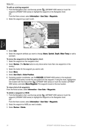
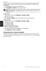
... > Go To (or Route To). To edit a route: 1. From the Home screen, select Information > User Data > Routes. 2. Where To? 26 GPSMAP® 4000/5000 Series Owner's Manual Your route is calculated. To delete a route: 1. To create a route using Auto Guidance (when using a preprogrammed BlueChart... 2. NOTE: You can edit the route name or edit the route turns. Select Review > Edit Route. Create a route as a Garmin GHP™ 10), you to trace it while creating a route. Navigating with a Garmin Autopilot When you start any type of the path and selecting Navigate To > Route To...
... > Go To (or Route To). To edit a route: 1. From the Home screen, select Information > User Data > Routes. 2. Where To? 26 GPSMAP® 4000/5000 Series Owner's Manual Your route is calculated. To delete a route: 1. To create a route using Auto Guidance (when using a preprogrammed BlueChart... 2. NOTE: You can edit the route name or edit the route turns. Select Review > Edit Route. Create a route as a Garmin GHP™ 10), you to trace it while creating a route. Navigating with a Garmin Autopilot When you start any type of the path and selecting Navigate To > Route To...
Owner's Manual
Page 38
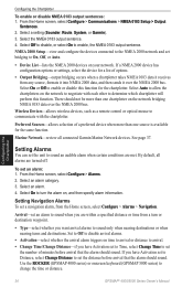
...From the Home screen, select Configure > Alarms. 2. Use the ROCKER (GPSMAP 4000 series) or onscreen keyboard (GPSMAP 5000 series) to On, Off, or Auto. • Device List-...Chartplotter To enable or disable NMEA 0183 output sentences: 1. By default, all connected Garmin Marine Network devices. See page 37. Select On to determine which chartplotter will perform this...review all alarms are met. Setting Navigation Alarms To set an alarm: 1. Preferred Sources-allows selection of options. • Output Bridging-output bridging occurs when a chartplotter takes NMEA 0183 data it receives...
...From the Home screen, select Configure > Alarms. 2. Use the ROCKER (GPSMAP 4000 series) or onscreen keyboard (GPSMAP 5000 series) to On, Off, or Auto. • Device List-...Chartplotter To enable or disable NMEA 0183 output sentences: 1. By default, all connected Garmin Marine Network devices. See page 37. Select On to determine which chartplotter will perform this...review all alarms are met. Setting Navigation Alarms To set an alarm: 1. Preferred Sources-allows selection of options. • Output Bridging-output bridging occurs when a chartplotter takes NMEA 0183 data it receives...
Owner's Manual
Page 42
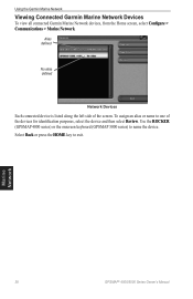
... select Review. To assign an alias or name to one of the screen. Select Back or press the HOME key to name the device. Marine Network 38 GPSMAP® 4000/5000 Series Owner's Manual Use the ROCKER (GPSMAP 4000 series) or the onscreen keyboard (GPSMAP 5000 series) to exit. Using the Garmin Marine Network Viewing Connected Garmin Marine Network...
... select Review. To assign an alias or name to one of the screen. Select Back or press the HOME key to name the device. Marine Network 38 GPSMAP® 4000/5000 Series Owner's Manual Use the ROCKER (GPSMAP 4000 series) or the onscreen keyboard (GPSMAP 5000 series) to exit. Using the Garmin Marine Network Viewing Connected Garmin Marine Network...
Owner's Manual
Page 54
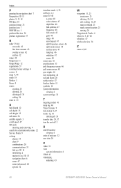
... it receives a distress call . Select Review to view details about the call from a VHF Radio When your Garmin chartplotter is connected to a Garmin NMEA 2000-compatible radio and you initiate a man-overboard DSC distress call . 2. Man-Overboard Distress Calls Initiated from your radio, your Garmin chartplotter ...recent call on activating navigation to the man-overboard point. Select from your radio, see page 23. 50 GPSMAP® 4000/5000 Series Owner's Manual This option is received from a chart screen, select Menu > Other Vessels > DSC List. The DSC List can use this ...
... it receives a distress call . Select Review to view details about the call from a VHF Radio When your Garmin chartplotter is connected to a Garmin NMEA 2000-compatible radio and you initiate a man-overboard DSC distress call . 2. Man-Overboard Distress Calls Initiated from your radio, your Garmin chartplotter ...recent call on activating navigation to the man-overboard point. Select from your radio, see page 23. 50 GPSMAP® 4000/5000 Series Owner's Manual This option is received from a chart screen, select Menu > Other Vessels > DSC List. The DSC List can use this ...
Owner's Manual
Page 56
...calls until you can use the chartplotter interface to set up an individual routine call to communicate. Select Review > Call with Radio. 3. On your call . On your Garmin chartplotter to a Garmin VHF NMEA 2000-compatible radio, you want to the radio. 4. To change the symbol and color ...of the following channels on which you can select one of the trail line for a specific vessel that is 72. DSC 52 GPSMAP® 4000/5000...
...calls until you can use the chartplotter interface to set up an individual routine call to communicate. Select Review > Call with Radio. 3. On your call . On your Garmin chartplotter to a Garmin VHF NMEA 2000-compatible radio, you want to the radio. 4. To change the symbol and color ...of the following channels on which you can select one of the trail line for a specific vessel that is 72. DSC 52 GPSMAP® 4000/5000...
Owner's Manual
Page 64
...43 overlay screen 42 surface 12 range 48 Range keys 1 Range Rings 12 registration 57 restoring factory settings 4 review 8 rings 9, 44 roads 18 Rocker 1 Roses 9 routes creating 25 deleting 26 deleting all 30 editing 26...destination by name 22 Service Points 9 settings alarms 34 chart 9 combinations 20 communications 33 fish eye 3D 16 initializing 2 mariner's eye 3D 15 navigation chart 6 sonar 47 sonar (advanced) 48 system 32 simulator mode 4, 32 soft keys i, ...5, 21-26 whiteline 47 wireless devices 34 Z zoom 6, 48 60 GPSMAP® 4000/5000 Series Owner's Manual
...43 overlay screen 42 surface 12 range 48 Range keys 1 Range Rings 12 registration 57 restoring factory settings 4 review 8 rings 9, 44 roads 18 Rocker 1 Roses 9 routes creating 25 deleting 26 deleting all 30 editing 26...destination by name 22 Service Points 9 settings alarms 34 chart 9 combinations 20 communications 33 fish eye 3D 16 initializing 2 mariner's eye 3D 15 navigation chart 6 sonar 47 sonar (advanced) 48 system 32 simulator mode 4, 32 soft keys i, ...5, 21-26 whiteline 47 wireless devices 34 Z zoom 6, 48 60 GPSMAP® 4000/5000 Series Owner's Manual