Owner's Manual
Page 23
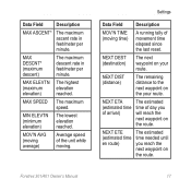
MIN ELEVTN (minimum elevation) The lowest elevation reached. NEXT DEST (destination) The next waypoint on the route. Foretrex 301/401 Owner's Manual 17 Settings Data Field Description MOV'N TIME (moving . NEXT ETE (estimated time en route) The estimated time needed until you...(maximum descent) The maximum descent rate in feet/meter per minute. MOV'N AVG (moving average) Average speed of the unit while moving time) A running tally of day you reach the next waypoint on the your route. NEXT DIST (distance) The remaining distance to the next waypoint on the route.
MIN ELEVTN (minimum elevation) The lowest elevation reached. NEXT DEST (destination) The next waypoint on the route. Foretrex 301/401 Owner's Manual 17 Settings Data Field Description MOV'N TIME (moving . NEXT ETE (estimated time en route) The estimated time needed until you...(maximum descent) The maximum descent rate in feet/meter per minute. MOV'N AVG (moving average) Average speed of the unit while moving time) A running tally of day you reach the next waypoint on the your route. NEXT DIST (distance) The remaining distance to the next waypoint on the route.

Owner's Manual
Page 24
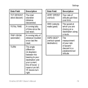
Settings Data Field ODOMETER OFF COURSE OVER'L SPD (overall speed) SPEED STOP TIME Description A running tally of travel to return to the route. The distance (left or right) you must travel ). Your average speed. Data Field SUNRISE SUNSET TIME .... Current time of sunset based on your GPS position. The direction you are from the original course (path of distance traveled, based upon the distance between second-bysecond position readings. The total elevation distance ascended. 18 Foretrex 301/401 Owner's Manual Time of day based on your time settings (format, time zone, ...
Settings Data Field ODOMETER OFF COURSE OVER'L SPD (overall speed) SPEED STOP TIME Description A running tally of travel to return to the route. The distance (left or right) you must travel ). Your average speed. Data Field SUNRISE SUNSET TIME .... Current time of sunset based on your GPS position. The direction you are from the original course (path of distance traveled, based upon the distance between second-bysecond position readings. The total elevation distance ascended. 18 Foretrex 301/401 Owner's Manual Time of day based on your time settings (format, time zone, ...
Owner's Manual
Page 25
... TRIP ODOM (odometer) TURN Description The total elevation distance descended. A running tally of time since last the reset. The angle difference (in degrees) between the bearing to a predetermined altitude. The speed at which you are closing on a destination along a route. Foretrex 301/401 Owner's Manual 19 Settings Data Field VERT SPEED* (vertical) VMG...
... TRIP ODOM (odometer) TURN Description The total elevation distance descended. A running tally of time since last the reset. The angle difference (in degrees) between the bearing to a predetermined altitude. The speed at which you are closing on a destination along a route. Foretrex 301/401 Owner's Manual 19 Settings Data Field VERT SPEED* (vertical) VMG...


