Owner's Manual
Page 5
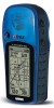
... responsibility of the owner/operator of the eTrex Legend to secure the GPS unit so that can propel objects in their path toward the driver or passengers causing possible injury. Refer to air bag safety precautions contained in accor- Do not mount the eTrex Legend in a place where the driver or... consequences thereof. dance with a rapid force that it in an accident or collision with an eTrex Legend to pay full attention to our web site at all driving conditions at http://www.garmin. iii Warnings and Precautions Do Not Place Unsecured on the Vehicle Dash Do Not Mount Where ...
... responsibility of the owner/operator of the eTrex Legend to secure the GPS unit so that can propel objects in their path toward the driver or passengers causing possible injury. Refer to air bag safety precautions contained in accor- Do not mount the eTrex Legend in a place where the driver or... consequences thereof. dance with a rapid force that it in an accident or collision with an eTrex Legend to pay full attention to our web site at all driving conditions at http://www.garmin. iii Warnings and Precautions Do Not Place Unsecured on the Vehicle Dash Do Not Mount Where ...
Owner's Manual
Page 6
...in GARMIN. Virtually all GPS equipment. Title, ownership rights and intellectual property rights in and to the Software remain in the normal operation of the product. The system is solely responsible for its accuracy and maintenance. Software License Agreement BY USING THE ETREX LEGEND, ...YOU AGREE TO BE BOUND BY THE TERMS AND CONDITIONS OF THE FOLLOWING SOFTWARE LICENSE AGREEMENT. Introduction Warnings and Precautions CAUTION: The Global Positioning System (GPS) is operated by the government of the ...
...in GARMIN. Virtually all GPS equipment. Title, ownership rights and intellectual property rights in and to the Software remain in the normal operation of the product. The system is solely responsible for its accuracy and maintenance. Software License Agreement BY USING THE ETREX LEGEND, ...YOU AGREE TO BE BOUND BY THE TERMS AND CONDITIONS OF THE FOLLOWING SOFTWARE LICENSE AGREEMENT. Introduction Warnings and Precautions CAUTION: The Global Positioning System (GPS) is operated by the government of the ...
Owner's Manual
Page 13
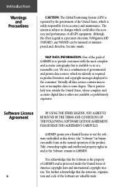
... screen, you can last up to turn on the backlight from any page on the backlight. Getting Started Installing the Batteries The eTrex Legend operates on the back of the unit. Remove the battery cover on two "AA" batteries (not included), which are removed.... Reinstall the battery cover by turning the D-ring 1/4 turn counter-clockwise & pull away clockwise. 2. When using 'Battery Saver' or 'Use With GPS Off' mode when not navigating, Alkaline batter- Rechargeable Alkaline, NiMH, NiCad or Lithium batteries may be used batteries. The unit is pressed again. Insert...
... screen, you can last up to turn on the backlight from any page on the backlight. Getting Started Installing the Batteries The eTrex Legend operates on the back of the unit. Remove the battery cover on two "AA" batteries (not included), which are removed.... Reinstall the battery cover by turning the D-ring 1/4 turn counter-clockwise & pull away clockwise. 2. When using 'Battery Saver' or 'Use With GPS Off' mode when not navigating, Alkaline batter- Rechargeable Alkaline, NiMH, NiCad or Lithium batteries may be used batteries. The unit is pressed again. Insert...
Owner's Manual
Page 15
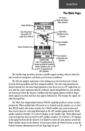
... It is helpful to other than RTCM mode), this feature searches for a WAAS satellite near your location and then receives data for correcting differentials in the GPS satellite signals and the WAAS satellite numbers (Number 33 or above you when the unit is ready for navigation, and...'Normal' and the interface set to orient the unit antenna toward the WAAS satellite shown in . When differential correction data has been received for GPS Satellites Your location coordinates and Elevation The Satellite Page provides a picture of satellite signal tracking, tells you at the sky from your...
... It is helpful to other than RTCM mode), this feature searches for a WAAS satellite near your location and then receives data for correcting differentials in the GPS satellite signals and the WAAS satellite numbers (Number 33 or above you when the unit is ready for navigation, and...'Normal' and the interface set to orient the unit antenna toward the WAAS satellite shown in . When differential correction data has been received for GPS Satellites Your location coordinates and Elevation The Satellite Page provides a picture of satellite signal tracking, tells you at the sky from your...
Owner's Manual
Page 16
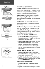
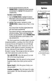
... a new, more than 600 miles from where you want to save battery power. New Elevation - Use the THUMB STICK to highlight the 'Use With GPS Off' option and then press it in this option when you are more accurate elevation, if known, to increase position accuracy. Highlight 'New Elevation' and... then press in on the THUMB STICK to activate. If you turn the unit on the THUMB STICK. To select the 'Use With GPS Off' option: 1. The eTrex Legend stops tracking satellites and should not be used the unit, select the 'New Location' and then the 'Use Map' options to approximate your...
... a new, more than 600 miles from where you want to save battery power. New Elevation - Use the THUMB STICK to highlight the 'Use With GPS Off' option and then press it in this option when you are more accurate elevation, if known, to increase position accuracy. Highlight 'New Elevation' and... then press in on the THUMB STICK to activate. If you turn the unit on the THUMB STICK. To select the 'Use With GPS Off' option: 1. The eTrex Legend stops tracking satellites and should not be used the unit, select the 'New Location' and then the 'Use Map' options to approximate your...
Owner's Manual
Page 17
...with instructions stating, "Point to your location, otherwise the unit displays a "Poor Satellite Reception" message. Select this option if today is necessary because GPS signals do not travel through rocks, buildings, people, metal, or heavy tree cover. Select this option if no other option applies. (The unit ...the page and then press it in to highlight the Option Menu button at the top of miles (from where you choose 'Auto' the eTrex Legend determines your location on satellite signals to display choices of the sky is not (date provided). Highlight 'OK' and press in . At ...
...with instructions stating, "Point to your location, otherwise the unit displays a "Poor Satellite Reception" message. Select this option if today is necessary because GPS signals do not travel through rocks, buildings, people, metal, or heavy tree cover. Select this option if no other option applies. (The unit ...the page and then press it in to highlight the Option Menu button at the top of miles (from where you choose 'Auto' the eTrex Legend determines your location on satellite signals to display choices of the sky is not (date provided). Highlight 'OK' and press in . At ...
Owner's Manual
Page 20
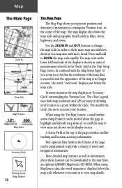
...' surrounding the 'Position Icon'. A Status Field at the bottom of the Unit Setup Page (not to be downloaded to the unit from an optional GARMIN MapSource CD-ROM. More detailed map features as well as information about the page to highlight and identify map items or to scroll the map... and navigation information. The map scale in the lower left hand side of movement as lakes, rivers, highways, and towns. The eTrex Legend uses both map resolution and GPS accuracy in order to show more accurate your location. The smaller the circle, the more map area with less detail or less map...
...' surrounding the 'Position Icon'. A Status Field at the bottom of the Unit Setup Page (not to be downloaded to the unit from an optional GARMIN MapSource CD-ROM. More detailed map features as well as information about the page to highlight and identify map items or to scroll the map... and navigation information. The map scale in the lower left hand side of movement as lakes, rivers, highways, and towns. The eTrex Legend uses both map resolution and GPS accuracy in order to show more accurate your location. The smaller the circle, the more map area with less detail or less map...
Owner's Manual
Page 23
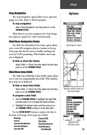
Hide/Show Data Fields The 'Hide Data Fields/Show Data Fields' option allows you to quit navigating on the THUMB STICK to view GPS navigation data in the data field. Highlight the desired option and then press in on a Goto, Route or Track in progress. Map Stop Navigation ... data field and then press it in a window at the top of the page that lists the status of satellite tracking and accuracy of GPS positioning. When there is no active navigation, the 'Stop Navigation' option is "grayed out" and is displayed. To hide or show Nav Status: Select 'Hide...
Hide/Show Data Fields The 'Hide Data Fields/Show Data Fields' option allows you to quit navigating on the THUMB STICK to view GPS navigation data in the data field. Highlight the desired option and then press in on a Goto, Route or Track in progress. Map Stop Navigation ... data field and then press it in a window at the top of the page that lists the status of satellite tracking and accuracy of GPS positioning. When there is no active navigation, the 'Stop Navigation' option is "grayed out" and is displayed. To hide or show Nav Status: Select 'Hide...
Owner's Manual
Page 26
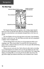
... your course over ground (track) while you're moving , but the data fields at the top of the page displays the status of the GPS Receiver and the approximate accuracy of your current position. When you are navigating a route. The Status Window at the top of the page shows you are...
... your course over ground (track) while you're moving , but the data fields at the top of the page displays the status of the GPS Receiver and the approximate accuracy of your current position. When you are navigating a route. The Status Window at the top of the page shows you are...
Owner's Manual
Page 54
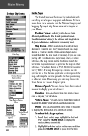
... Format Options Menu Map Datum Options Menu Distance/Speed Options Vertical Speed Options Elevation Options Depth Options 44 Units Page The Units features are comparing GPS coordinates to display your rate of travel.
... Format Options Menu Map Datum Options Menu Distance/Speed Options Vertical Speed Options Elevation Options Depth Options 44 Units Page The Units features are comparing GPS coordinates to display your rate of travel.
Owner's Manual
Page 56
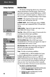
... output of location and velocity information without output capabilities. Text Out - To select a serial data format: 1. Main Menu Setup Options GARMIN Mode with No Options GARMIN Differntial GPS Mode with Data and Options Fields 46 Interface Page The Interface Settings Page allows you select 'User' from the Beacon list to control a GARMIN differential beacon receiver (e.g.
... output of location and velocity information without output capabilities. Text Out - To select a serial data format: 1. Main Menu Setup Options GARMIN Mode with No Options GARMIN Differntial GPS Mode with Data and Options Fields 46 Interface Page The Interface Settings Page allows you select 'User' from the Beacon list to control a GARMIN differential beacon receiver (e.g.
Owner's Manual
Page 57
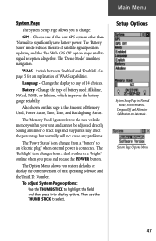
...refers to select. Number. Main Menu System Page The System Setup Page allows you restore defaults or display the current version of the four GPS options other than 'Normal' to significantly save battery power. The 'Battery Saver' mode reduces the rate of WAAS capabilities. See... page 5 for an explanation of satellite signal position updating and the 'Use With GPS Off' option stops satellite signal reception altogether. The 'Backlight' icon changes from a "battery" to an "electric plug" when external power is the...
...refers to select. Number. Main Menu System Page The System Setup Page allows you restore defaults or display the current version of the four GPS options other than 'Normal' to significantly save battery power. The 'Battery Saver' mode reduces the rate of WAAS capabilities. See... page 5 for an explanation of satellite signal position updating and the 'Use With GPS Off' option stops satellite signal reception altogether. The 'Backlight' icon changes from a "battery" to an "electric plug" when external power is the...
Owner's Manual
Page 62
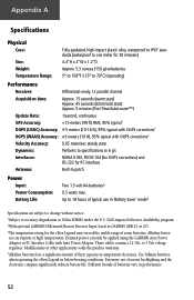
Appendix A Specifications Physical Case: Size: Weight: Temperature Range: Fully-gasketed, high-impact plastic alloy, waterproof to IPX7 standards (waterproof to one meter for 30 minutes) 4.4"H x 2"W x 1.2"D Approx. 5.3 ounces (150 g) w/batteries 5° to 158°F (-15° to 70°C) (operating) Performance Receiver: Differential-ready, 12 parallel channel Acquisition time: Approx. 15 seconds (warm start) Approx. 45 seconds (EZinit/cold start) Approx. 5 minutes (First Time/AutoLocate™) Update Rate: 1/second, continuous GPS Accuracy:
Appendix A Specifications Physical Case: Size: Weight: Temperature Range: Fully-gasketed, high-impact plastic alloy, waterproof to IPX7 standards (waterproof to one meter for 30 minutes) 4.4"H x 2"W x 1.2"D Approx. 5.3 ounces (150 g) w/batteries 5° to 158°F (-15° to 70°C) (operating) Performance Receiver: Differential-ready, 12 parallel channel Acquisition time: Approx. 15 seconds (warm start) Approx. 45 seconds (EZinit/cold start) Approx. 5 minutes (First Time/AutoLocate™) Update Rate: 1/second, continuous GPS Accuracy:
Owner's Manual
Page 64
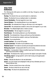
... selected time zone. 54 Your moving . Time of travel ). Current ETA - Final Distance - Off Course - Indicates the direction to a destination. Course - Current ETE - Your current GPS position. A running tally of day you are available on map. Overall Avg. The next waypoint on your route. Final Destination - The time for both moving...
... selected time zone. 54 Your moving . Time of travel ). Current ETA - Final Distance - Off Course - Indicates the direction to a destination. Course - Current ETE - Your current GPS position. A running tally of day you are available on map. Overall Avg. The next waypoint on your route. Final Destination - The time for both moving...
Owner's Manual
Page 67
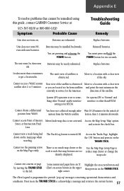
... Off. System GPS operation is obstructed Move to a location with a clear view satellite after 2 to provide "pop-up" messages concerning operational characteristics and conditions. The Track Log feature is not activated. Some menus and pages have not collected enough infor- The eTrex Legend is for two...Cannot view a track being laid down on . The unit's view of satellites is such that cannot be remedied using this guide, contact GARMIN Customer Service at: 913-397-8200 or 800-800-1020 Symptom Probable Cause Troubleshooting Guide Remedy Unit does not turn ON, even with ...
... Off. System GPS operation is obstructed Move to a location with a clear view satellite after 2 to provide "pop-up" messages concerning operational characteristics and conditions. The Track Log feature is not activated. Some menus and pages have not collected enough infor- The eTrex Legend is for two...Cannot view a track being laid down on . The unit's view of satellites is such that cannot be remedied using this guide, contact GARMIN Customer Service at: 913-397-8200 or 800-800-1020 Symptom Probable Cause Troubleshooting Guide Remedy Unit does not turn ON, even with ...
Owner's Manual
Page 68
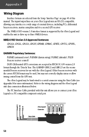
..., GPGLL, GPGSA, GPGSV, GPRMB, GPRMC, GPRTE, GPVTG, GPWPL, GPBOD GARMIN Proprietary Sentences: PGRME (estimated error), PGRMM (datum string), PGRMZ (altitude), PSLIB (beacon receiver control) DGPS (Differential GPS) corrections are the recommended beacon receivers for more information). The PC Interface Cable provided with the eTrex Legend. Other beacon receivers with the correct RTCM format may not correctly display...
..., GPGLL, GPGSA, GPGSV, GPRMB, GPRMC, GPRTE, GPVTG, GPWPL, GPBOD GARMIN Proprietary Sentences: PGRME (estimated error), PGRMM (datum string), PGRMZ (altitude), PSLIB (beacon receiver control) DGPS (Differential GPS) corrections are the recommended beacon receivers for more information). The PC Interface Cable provided with the eTrex Legend. Other beacon receivers with the correct RTCM format may not correctly display...
Owner's Manual
Page 70
Index Daylight Savings Time 43 Delete Note 49 Waypoint 27 Demo Mode 47 Depth 44 Destination 13, 18, 21 Detail, Map 14 Differential GPS (DGPS 58 Display 45 Display Backlighting 3 Display Mode 14 Display Page 45 Distance 13, 18, 21, 44 Distance/Speed 44 Distance to Point... Favorite 29 Intersection 32 Point of Interest 31 Waypoint 28 FIND button 2, 27 Find Menu 23, 27 G GARMIN DGPS 46 Limited Warranty vi, vii Proprietary Sentences 58 Getting Started 1 Glide Ratio 21 Global Positioning System (GPS 3, 5, 47, 52, 58, iii Goto Cancelling (Stop Navigation) 11, 13, 34, 40 Functions 8, ...
Index Daylight Savings Time 43 Delete Note 49 Waypoint 27 Demo Mode 47 Depth 44 Destination 13, 18, 21 Detail, Map 14 Differential GPS (DGPS 58 Display 45 Display Backlighting 3 Display Mode 14 Display Page 45 Distance 13, 18, 21, 44 Distance/Speed 44 Distance to Point... Favorite 29 Intersection 32 Point of Interest 31 Waypoint 28 FIND button 2, 27 Find Menu 23, 27 G GARMIN DGPS 46 Limited Warranty vi, vii Proprietary Sentences 58 Getting Started 1 Glide Ratio 21 Global Positioning System (GPS 3, 5, 47, 52, 58, iii Goto Cancelling (Stop Navigation) 11, 13, 34, 40 Functions 8, ...
Owner's Manual
Page 73
Number 47 Use With GPS Off 6, 7 Using Find Menu 48 Goto 34 Main Menu 23 63 Index Restore settings 36, 37 Route Page 23 Using 35 RTCM In 46 RTCM ... Trip Time Moving 14, 18, 21, 55 Stopped 14, 18, 21, 55 Total 14, 18, 21, 55 Troubleshooting 57 Turn 14, 18, 21, 55 Turning GPS Receiver "off 6 U Units of Measure 10, 23, 43, 44 Units Page 44 Unit I.D.
Number 47 Use With GPS Off 6, 7 Using Find Menu 48 Goto 34 Main Menu 23 63 Index Restore settings 36, 37 Route Page 23 Using 35 RTCM In 46 RTCM ... Trip Time Moving 14, 18, 21, 55 Stopped 14, 18, 21, 55 Total 14, 18, 21, 55 Troubleshooting 57 Turn 14, 18, 21, 55 Turning GPS Receiver "off 6 U Units of Measure 10, 23, 43, 44 Units Page 44 Unit I.D.
Quick Reference Guide
Page 1
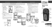
... START GUIDE Internal GPS Antenna External Power/Data Connector (on back) Thumb Stick Page Button Power Button Battery Compartment (on a Goto Map Page Options Menu © Copyright 2005 GARMIN Ltd. Use the THUMB STICK to go. The Navigation Page displays the 'Bearing Pointer' indicating the direction ...display the Information Page. 5. Move back and forth between the Map Page and the Navigation page to check your progress and verify your eTrex Legend requires only three steps: mark, move to the Map Page to see your path of several methods to help you can't always travel...
... START GUIDE Internal GPS Antenna External Power/Data Connector (on back) Thumb Stick Page Button Power Button Battery Compartment (on a Goto Map Page Options Menu © Copyright 2005 GARMIN Ltd. Use the THUMB STICK to go. The Navigation Page displays the 'Bearing Pointer' indicating the direction ...display the Information Page. 5. Move back and forth between the Map Page and the Navigation page to check your progress and verify your eTrex Legend requires only three steps: mark, move to the Map Page to see your path of several methods to help you can't always travel...


