Navigation Owner's Manual (english)
Page 2
however, we still recommend that you for choosing the Alpine INE-W957HD/X008U/X009 as your device right away. Thank you read this manual to fully understand the screens and features. 2 Start using it; This document is the detailed description of the navigation software. You can easily discover the software while you are using your navigator.
however, we still recommend that you for choosing the Alpine INE-W957HD/X008U/X009 as your device right away. Thank you read this manual to fully understand the screens and features. 2 Start using it; This document is the detailed description of the navigation software. You can easily discover the software while you are using your navigator.
Navigation Owner's Manual (english)
Page 3
Table of contents 1 Warnings and Safety information 6 2 Getting started 7 2.1 Buttons and other controls on the screen 8 2.1.1 Using keyboards 9 2.1.2 Beyond single screen tap 10 2.2 Map screen...11 2.2.1 Navigating on the map 11 2.2.2 Position markers 13 2.2.2.1 Vehimarker and Lock-on-Road 13...30 3.1.2 Selecting the destination from the Places of Interest 31 3.1.2.1 Quick search for a Place of Interest 31 3.1.2.2 Searching for a Place of Interest using preset categories 32 3.1.2.3 Searching for a Place of Interest by category 35 3.1.2.4 Searching for a Place of Interest by name 37...
Table of contents 1 Warnings and Safety information 6 2 Getting started 7 2.1 Buttons and other controls on the screen 8 2.1.1 Using keyboards 9 2.1.2 Beyond single screen tap 10 2.2 Map screen...11 2.2.1 Navigating on the map 11 2.2.2 Position markers 13 2.2.2.1 Vehimarker and Lock-on-Road 13...30 3.1.2 Selecting the destination from the Places of Interest 31 3.1.2.1 Quick search for a Place of Interest 31 3.1.2.2 Searching for a Place of Interest using preset categories 32 3.1.2.3 Searching for a Place of Interest by category 35 3.1.2.4 Searching for a Place of Interest by name 37...

Navigation Owner's Manual (english)
Page 4
... 47 3.4.3 Editing the list of destinations (Edit Route 48 3.4.4 Cancelling the active route 49 3.4.5 Checking route alternatives 49 3.4.6 Changing the vehicle used in route planning 50 3.4.7 Changing the road types used in route planning 51 3.5 Saving a location as an Address Book entry 53 3.6 Saving a location as an alert point 54 3.7 Editing an...
... 47 3.4.3 Editing the list of destinations (Edit Route 48 3.4.4 Cancelling the active route 49 3.4.5 Checking route alternatives 49 3.4.6 Changing the vehicle used in route planning 50 3.4.7 Changing the road types used in route planning 51 3.5 Saving a location as an Address Book entry 53 3.6 Saving a location as an alert point 54 3.7 Editing an...
Navigation Owner's Manual (english)
Page 7
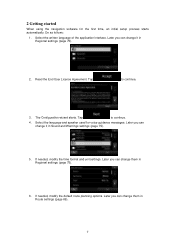
... can change them in Sound and Warnings settings (page 75). 5. Later you can change it in Route settings (page 69). 7 Select the language and speaker used for the first time, an initial setup process starts automatically. Tap to continue. 4. Select the written language of the application interface. Tap to continue. 3. 2 Getting...
... can change them in Sound and Warnings settings (page 75). 5. Later you can change it in Route settings (page 69). 7 Select the language and speaker used for the first time, an initial setup process starts automatically. Tap to continue. 4. Select the written language of the application interface. Tap to continue. 3. 2 Getting...
Navigation Owner's Manual (english)
Page 8
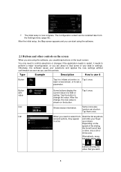
...to select from the Settings menu (page 65). Tap the button to lose some of your data or settings. The Configuration wizard can start using the software, you are about to change , the new value is now complete. After the initial setup, the Map screen appears and you... as you want. 8 Tap them once. When you need to confirm selections or changes if the application needs to restart, it needs to use the controls. Shows status information. Grab the list anywhere and slide your selections and applies the new settings without confirmation as soon as a button...
...to select from the Settings menu (page 65). Tap the button to lose some of your data or settings. The Configuration wizard can start using the software, you are about to change , the new value is now complete. After the initial setup, the Map screen appears and you... as you want. 8 Tap them once. When you need to confirm selections or changes if the application needs to restart, it needs to use the controls. Shows status information. Grab the list anywhere and slide your selections and applies the new settings without confirmation as soon as a button...
Navigation Owner's Manual (english)
Page 9
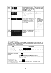
... values in multi-word street names Tap the button at the bottom centre of lists. Tap and hold the button to enter text and numbers. used instead of the screen. 9 Only one of the buttons choices, radio buttons may be to select a new value. Tap it . Radio button Switch Slider Virtual... keyboar d When there are only two choices, a checkmark shows whether the feature is a touch screen button. 2.1.1 Using keyboards You only need to enter letters or numbers when you cannot avoid it to turn the switch on or off.
... values in multi-word street names Tap the button at the bottom centre of lists. Tap and hold the button to enter text and numbers. used instead of the screen. 9 Only one of the buttons choices, radio buttons may be to select a new value. Tap it . Radio button Switch Slider Virtual... keyboar d When there are only two choices, a checkmark shows whether the feature is a touch screen button. 2.1.1 Using keyboards You only need to enter letters or numbers when you cannot avoid it to turn the switch on or off.
Navigation Owner's Manual (english)
Page 10
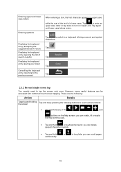
...: you can delete several characters quickly. • Tap and hold or in long lists: you can be accessed with combined touch screen tapping. However, some useful features can rotate, tilt or scale the map continuously. • Tap and hold on Caps Lock. Tap again and lower case letters return.
...: you can delete several characters quickly. • Tap and hold or in long lists: you can be accessed with combined touch screen tapping. However, some useful features can rotate, tilt or scale the map continuously. • Tap and hold on Caps Lock. Tap again and lower case letters return.
Navigation Owner's Manual (english)
Page 11
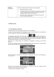
... and drag it to the other half. When there is no GPS position, the Vehimarker is displayed in full colour, now showing your Alpine INE-W957HD/X008U/X009 audio system to appear on the left corner. It shows your finger up or down. Two data fields are displayed on the other side...; Scrolling the list: grab the list anywhere and slide your last known position. You can decide which side of the map is the most frequently used screen of the software. The more green dots you see coloured dots circling around a satellite symbol in the top left . 11 Gestures (drag&drop) You...
... and drag it to the other half. When there is no GPS position, the Vehimarker is displayed in full colour, now showing your Alpine INE-W957HD/X008U/X009 audio system to appear on the left corner. It shows your finger up or down. Two data fields are displayed on the other side...; Scrolling the list: grab the list anywhere and slide your last known position. You can decide which side of the map is the most frequently used screen of the software. The more green dots you see coloured dots circling around a satellite symbol in the top left . 11 Gestures (drag&drop) You...
Navigation Owner's Manual (english)
Page 13
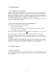
... (page 40) When a map location is selected, the Cursor appears at the icon of a Place of Interest or an alert point, the object will be used as the destination of the route, a new alert point, you can also select some of the road. If you tap the map at the selected... all zoom levels. The location of the Cursor can be selected (you see a red circling border around it, or you can save this object or use it visible at your current heading. 2.2.2.2 Selected map location (Cursor) and selected map object You can mark a map location in the following ways: • Tap...
... (page 40) When a map location is selected, the Cursor appears at the icon of a Place of Interest or an alert point, the object will be used as the destination of the route, a new alert point, you can also select some of the road. If you tap the map at the selected... all zoom levels. The location of the Cursor can be selected (you see a red circling border around it, or you can save this object or use it visible at your current heading. 2.2.2.2 Selected map location (Cursor) and selected map object You can mark a map location in the following ways: • Tap...

Navigation Owner's Manual (english)
Page 15
... If you need to take. If you want to take the appropriate lane in the map data, the software displays the lanes and their directions using small arrows at the top of them and the normal Map screen returns until new signpost information is displayed in Visual Guidance settings. 15 These...
... If you need to take. If you want to take the appropriate lane in the map data, the software displays the lanes and their directions using small arrows at the top of them and the normal Map screen returns until new signpost information is displayed in Visual Guidance settings. 15 These...
Navigation Owner's Manual (english)
Page 16
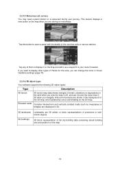
... software supports the following 3D object types: Type Description 3D terrain 3D terrain map data shows changes in terrain, elevations or depressions in 2D, and use it as overpasses or bridges) are displayed in 3D. 3D landmarks Landmarks are driving on the map. 16 2.2.3.5 Motorway exit services You may need a petrol...
... software supports the following 3D object types: Type Description 3D terrain 3D terrain map data shows changes in terrain, elevations or depressions in 2D, and use it as overpasses or bridges) are displayed in 3D. 3D landmarks Landmarks are driving on the map. 16 2.2.3.5 Motorway exit services You may need a petrol...
Navigation Owner's Manual (english)
Page 17
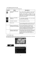
... events Road segments may be affected by traffic events are near, it will include them in night colour mode. However, when your software uses the last known position as the start point. Destination (end point) The final destination of the route before reaching the final destination. Streets... Your software shows the route in an alternate colour, and small symbols displayed along the route show the nature of the event: Tap to use or excluded from the current position. If there is available, the route starts from the navigation avoid certain road types (page 69). 2.2.3.7...
... events Road segments may be affected by traffic events are near, it will include them in night colour mode. However, when your software uses the last known position as the start point. Destination (end point) The final destination of the route before reaching the final destination. Streets... Your software shows the route in an alternate colour, and small symbols displayed along the route show the nature of the event: Tap to use or excluded from the current position. If there is available, the route starts from the navigation avoid certain road types (page 69). 2.2.3.7...
Navigation Owner's Manual (english)
Page 19
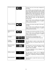
... large steps, or tap and hold the button to follow the current GPS position. Tap this button to modify it continuously and smoothly. Your software uses high-quality vector maps that you need. Automatic map rotation is displayed on the screen. Tap the button once to modify the view in 3D...
... large steps, or tap and hold the button to follow the current GPS position. Tap this button to modify it continuously and smoothly. Your software uses high-quality vector maps that you need. Automatic map rotation is displayed on the screen. Tap the button once to modify the view in 3D...
Navigation Owner's Manual (english)
Page 20
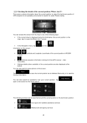
... contains information about the current position (or about the last known position if GPS reception is not available) and a button to open a new screen for useful Places nearby. . 2.2.5 Checking the details of the current position (Where Am I ?
... contains information about the current position (or about the last known position if GPS reception is not available) and a button to open a new screen for useful Places nearby. . 2.2.5 Checking the details of the current position (Where Am I ?
Navigation Owner's Manual (english)
Page 21
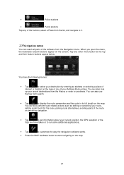
... search buttons appear on the map or one of the buttons, select a Place from the list, and navigate to it. 2.3 Navigation menu You can also use the free form search. • Tap to start point for the route, picking route alternatives, avoiding parts of the software from the History or enter...
... search buttons appear on the map or one of the buttons, select a Place from the list, and navigate to it. 2.3 Navigation menu You can also use the free form search. • Tap to start point for the route, picking route alternatives, avoiding parts of the software from the History or enter...
Navigation Owner's Manual (english)
Page 22
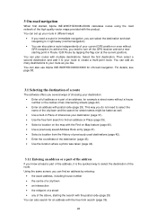
...you do not need a route for off the GPS receiver and set up your route in different ways: • If you can also use Alpine INE-W957HD/X008U/X009 for immediate navigation, you need to select the name of the city/town and the search for an address with the free form search... (page 39). 22 3 On-road navigation When first started, Alpine INE-W957HD/X008U/X009 calculates routes using the road network of the high quality vector maps provided with multiple destinations. You can also search for street names might be faster...
...you do not need a route for off the GPS receiver and set up your route in different ways: • If you can also use Alpine INE-W957HD/X008U/X009 for immediate navigation, you need to select the name of the city/town and the search for an address with the free form search... (page 39). 22 3 On-road navigation When first started, Alpine INE-W957HD/X008U/X009 calculates routes using the road network of the high quality vector maps provided with multiple destinations. You can also search for street names might be faster...
Navigation Owner's Manual (english)
Page 25
... entering the street name on the keyboard. To accept it, tap . • If the desired name does not show up, the names that you will use this step is always shown in the input field. Tap needed). (if you can navigate to the midpoint of results before tapping to confirm the...
... entering the street name on the keyboard. To accept it, tap . • If the desired name does not show up, the names that you will use this step is always shown in the input field. Tap needed). (if you can navigate to the midpoint of results before tapping to confirm the...
Navigation Owner's Manual (english)
Page 29
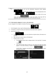
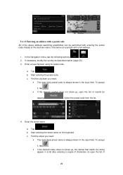
... All of the above address searching possibilities can be performed with a full address: 1. Start entering the street name on the keyboard. Enter a new city/town using its postal code: a. Tap . Find the city/town you need : • The most likely street name is always shown in the input field.
... All of the above address searching possibilities can be performed with a full address: 1. Start entering the street name on the keyboard. Enter a new city/town using its postal code: a. Tap . Find the city/town you need : • The most likely street name is always shown in the input field.
Navigation Owner's Manual (english)
Page 31
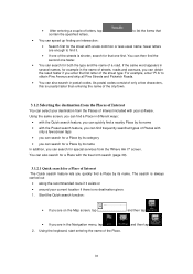
... find frequently searched types of Interest included with a less common or less usual name; Verify that • You can search for a Place by its name. Using the keyboard, start entering the name of the streets is shorter, search for the street with your current location if there is no destination given... out • along the recommended route if it . • If one of the Place. 31 The file may hav e been mov ed, renamed, or deleted. Using the same screen, you can find a Place in the name of streets, roads and avenues, you can obtain the result faster if you are enough...
... find frequently searched types of Interest included with a less common or less usual name; Verify that • You can search for a Place by its name. Using the keyboard, start entering the name of the streets is shorter, search for the street with your current location if there is no destination given... out • along the recommended route if it . • If one of the Place. 31 The file may hav e been mov ed, renamed, or deleted. Using the same screen, you can find a Place in the name of streets, roads and avenues, you can obtain the result faster if you are enough...
Navigation Owner's Manual (english)
Page 32
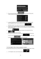
... sequence. 4. (optional) The Places in the middle. The route is displayed at the top of the screen. 6. (optional) Tap to see the details of Interest using preset categories The Preset search feature lets you need to modify route parameters, or tap and start your journey. 3.1.2.2 Searching for a Place of the selected...
... sequence. 4. (optional) The Places in the middle. The route is displayed at the top of the screen. 6. (optional) Tap to see the details of Interest using preset categories The Preset search feature lets you need to modify route parameters, or tap and start your journey. 3.1.2.2 Searching for a Place of the selected...


