User Manual
Page 1
... lost are not guaranteed to be used to your GPS by the unit while driving. Contact your local waste disposal department for aircraft navigation. Do not access the GPS functions while driving. It does not reflect road closures or road conditions, traffic congestion..., weather conditions, or other operational functions. Never store your Nextar GPS Navigator. This product should not be accurate in every situation. Just enter information using the touch screen and let the voice prompt and ...
... lost are not guaranteed to be used to your GPS by the unit while driving. Contact your local waste disposal department for aircraft navigation. Do not access the GPS functions while driving. It does not reflect road closures or road conditions, traffic congestion..., weather conditions, or other operational functions. Never store your Nextar GPS Navigator. This product should not be accurate in every situation. Just enter information using the touch screen and let the voice prompt and ...
User Manual
Page 4
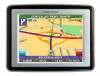
Table of Contents Introduction Important Safety Information 1 FCC & UL Compliance 3 Getting Familiar With Your Hardware Main Unit 5 Accessories 6 Power Adaptor 7 System Connections 8 Using the Mounting Bracket 9 Using Your Navigator General Setup 10 Playing Music 15 Photo Viewer 17 Service & Support Troubleshooting 20 Specifications 22 Copyright 23 4
Table of Contents Introduction Important Safety Information 1 FCC & UL Compliance 3 Getting Familiar With Your Hardware Main Unit 5 Accessories 6 Power Adaptor 7 System Connections 8 Using the Mounting Bracket 9 Using Your Navigator General Setup 10 Playing Music 15 Photo Viewer 17 Service & Support Troubleshooting 20 Specifications 22 Copyright 23 4
User Manual
Page 10
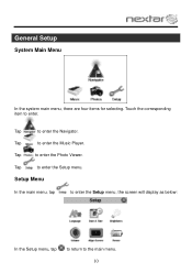
Tap to enter. Touch the corresponding item to enter the Setup menu. Tap to the main menu. 10 Setup Menu In the main menu, tap to enter the Setup menu, the screen will display as below: In the Setup menu, tap to return to enter the Photo Viewer. General Setup System Main Menu In the system main menu, there are four items for selecting. Tap to enter the Navigator. Tap to enter the Music Player.
Tap to enter. Touch the corresponding item to enter the Setup menu. Tap to the main menu. 10 Setup Menu In the main menu, tap to enter the Setup menu, the screen will display as below: In the Setup menu, tap to return to enter the Photo Viewer. General Setup System Main Menu In the system main menu, there are four items for selecting. Tap to enter the Navigator. Tap to enter the Music Player.
User Manual
Page 15
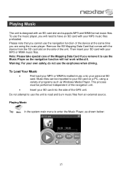
... Your Music First load your MP3 or WMA formatted music onto your personal SD card. Music files can be performed independent of the navigation unit. Insert your SD card into the side of programs such as Windows Media Player. Note: Please take special care of the unit.... Playing Music Tap in the system main menu to enter the Music Player, as the navigation function will need to your SD card on the side of the Mapping Data Card if you are using a variety of the GPS unit. Please...
... Your Music First load your MP3 or WMA formatted music onto your personal SD card. Music files can be performed independent of the navigation unit. Insert your SD card into the side of programs such as Windows Media Player. Note: Please take special care of the unit.... Playing Music Tap in the system main menu to enter the Music Player, as the navigation function will need to your SD card on the side of the Mapping Data Card if you are using a variety of the GPS unit. Please...
User Manual
Page 17
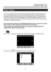
We suggest 640 x 480 pixel resolution files. To use the Photo Viewer, you will not work without it to use the navigation function of the device at the same time you remove it . Remove the SD Mapping Data Card that you cannot use the Photo Viewer as ... with your JPEG picture files. Then insert your JPEG picture files preloaded. Tap in the system main menu to enter the Photo Viewer, as the navigation function will need to enter the folder menu, as shown below : In the menu, tap to have an SD card with the device from the...
We suggest 640 x 480 pixel resolution files. To use the Photo Viewer, you will not work without it to use the navigation function of the device at the same time you remove it . Remove the SD Mapping Data Card that you cannot use the Photo Viewer as ... with your JPEG picture files. Then insert your JPEG picture files preloaded. Tap in the system main menu to enter the Photo Viewer, as the navigation function will need to enter the folder menu, as shown below : In the menu, tap to have an SD card with the device from the...
User Manual
Page 21
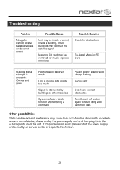
... normal status, please unplug the power supply cord and then plug it into the outlet again to side too much Signal is unstable. Troubleshooting Problem Navigator cannot receive satellite signals or does not orient Possible Cause Unit may be inside a tunnel, inside a building, or tall buildings may obstruct the satellite signal...
... normal status, please unplug the power supply cord and then plug it into the outlet again to side too much Signal is unstable. Troubleshooting Problem Navigator cannot receive satellite signals or does not orient Possible Cause Unit may be inside a tunnel, inside a building, or tall buildings may obstruct the satellite signal...
X3-11 software manual
Page 3
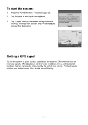
... ceilings, trees, and nearby tall buildings. Getting a GPS signal To use the system to guide you are ready to the warning. The screen appears. 2 Tap Navigate. A warning screen appears. 3 Tap "I Agree" after you have read and agreed to set your vehicle.
... ceilings, trees, and nearby tall buildings. Getting a GPS signal To use the system to guide you are ready to the warning. The screen appears. 2 Tap Navigate. A warning screen appears. 3 Tap "I Agree" after you have read and agreed to set your vehicle.

X3-11 software manual
Page 6
... arrow is yellow the GPS signal is a scale indicating your current zoom level. To return to the regular map view, press the "X" button. - 6 - As you navigate to a destination, the top of the map displays the name of the next street, the direction of your current position, you can view any of...
... arrow is yellow the GPS signal is a scale indicating your current zoom level. To return to the regular map view, press the "X" button. - 6 - As you navigate to a destination, the top of the map displays the name of the next street, the direction of your current position, you can view any of...
X3-11 software manual
Page 22
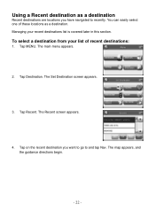
Using a Recent destination as a destination. Managing your list of these locations as a destination Recent destinations are locations you want to go to recently. The main menu appears. 2. The Set Destination screen appears. 3. Tap on the recent destination you have navigated to and tap Nav. To select a destination from your recent destinations list is covered later in this section. Tap Destination. The Recent screen appears. 4. The map appears, and the guidance directions begin. - 22 - You can easily select one of recent destinations: 1. Tap MENU. Tap Recent.
Using a Recent destination as a destination. Managing your list of these locations as a destination Recent destinations are locations you want to go to recently. The main menu appears. 2. The Set Destination screen appears. 3. Tap on the recent destination you have navigated to and tap Nav. To select a destination from your recent destinations list is covered later in this section. Tap Destination. The Recent screen appears. 4. The map appears, and the guidance directions begin. - 22 - You can easily select one of recent destinations: 1. Tap MENU. Tap Recent.
X3-11 software manual
Page 27
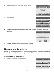
A confirmation message appears asking if you add to give them descriptive names. Managing your favorites list You can also remove destinations from your favorites list: 1. To manage your favorites list. The Destination Options screen appears. 3. Tap Yes. 2. The main menu appears. - 27 - The map appears and navigation continues. You can edit the destinations you want to continue to your favorites list to your final destination. 5. Tap Destination. Tap Stopover. 4. Tap X. Tap MENU.
A confirmation message appears asking if you add to give them descriptive names. Managing your favorites list You can also remove destinations from your favorites list: 1. To manage your favorites list. The Destination Options screen appears. 3. Tap Yes. 2. The main menu appears. - 27 - The map appears and navigation continues. You can edit the destinations you want to continue to your favorites list to your final destination. 5. Tap Destination. Tap Stopover. 4. Tap X. Tap MENU.
X3-11 software manual
Page 38
...™ is expressly forbidden. We reserve the right to modify, amend or otherwise change without prior written consent of Nextar, Inc. Mapping database copyright © 2006 NAVTEQ ™. Nextar may find it necessary to do this at : - 38 - No part of this manual may be copied, ...republished, reproduced, transmitted or distributed in any prior notice. Any unauthorized distribution of this manual is a trademark of NAVTEQ ™ Navigation software copyright © 2001...
...™ is expressly forbidden. We reserve the right to modify, amend or otherwise change without prior written consent of Nextar, Inc. Mapping database copyright © 2006 NAVTEQ ™. Nextar may find it necessary to do this at : - 38 - No part of this manual may be copied, ...republished, reproduced, transmitted or distributed in any prior notice. Any unauthorized distribution of this manual is a trademark of NAVTEQ ™ Navigation software copyright © 2001...
X3-11 QSG_Eng
Page 1
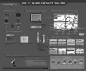
r X3-11 QUICKSTART GUIDE ACCESSORIES LIST II 3.5" GPS Device Carry Pouch HOW TO TURN ON THE DEVICE KEYPAD OPERATION AND SCREEN ICONS Distance to other states Input ... 0ST 41 mi -77T 47 mph Mute Map Scale Indicator Estimated Time of the GPS O - 2 1. Used to connect to Destination Current Speed QUICK STEPS TO NAVIGATE NAVTEQ MAPS Press Menu Select Destination Menu Destination Settim7Islli Itinerary i1 InfonsAS Locator Vas Select Address Set Destination lIAMdM drcrW Favonhas 1T- Press the "ON...
r X3-11 QUICKSTART GUIDE ACCESSORIES LIST II 3.5" GPS Device Carry Pouch HOW TO TURN ON THE DEVICE KEYPAD OPERATION AND SCREEN ICONS Distance to other states Input ... 0ST 41 mi -77T 47 mph Mute Map Scale Indicator Estimated Time of the GPS O - 2 1. Used to connect to Destination Current Speed QUICK STEPS TO NAVIGATE NAVTEQ MAPS Press Menu Select Destination Menu Destination Settim7Islli Itinerary i1 InfonsAS Locator Vas Select Address Set Destination lIAMdM drcrW Favonhas 1T- Press the "ON...


