
X3-09 Hardware Manual
Page 17
... on the user's SD card. Music files can be imported to the user's SD card on the side of the unit. Remove the mapping software SD card that you cannot use the music player, you are using a variety of programs such as Windows Media Player. This process... your own safety, do not use the earphones when driving. This is designed with your favorite music files. To use the navigation function of the mapping SD card if you remove it . Note: Please take care of the device at the same time you will not work without it to use...
... on the user's SD card. Music files can be imported to the user's SD card on the side of the unit. Remove the mapping software SD card that you cannot use the music player, you are using a variety of programs such as Windows Media Player. This process... your own safety, do not use the earphones when driving. This is designed with your favorite music files. To use the navigation function of the mapping SD card if you remove it . Note: Please take care of the device at the same time you will not work without it to use...

X3-09 Hardware Manual
Page 19
... SD card that you cannot use the navigation function of the unit. Note: Please take care of the mapping SD card if you will not work without it to enter the folder menu, as the navigation function will need to have an SD card ...
... SD card that you cannot use the navigation function of the unit. Note: Please take care of the mapping SD card if you will not work without it to enter the folder menu, as the navigation function will need to have an SD card ...
X3-09 Software Manual
Page 2
... screen 8 2.2.1 Using keyboards 9 2.3 Using the map 10 2.3.1 Checking the details of a map location 10 2.3.2 Manipulating the map 11 2.3.3 Status information and hidden controls on the map 13 2.3.4 Using the Cursor (the selected map location 15 2.4 Nextar Navigation System concepts 16 2.4.1 Smart Zoom 16 2.4.2 ... Track Logs 20 2.4.8 Route demonstration 21 2.4.9 POI (Points of Interest 21 2.4.10 Speed limit warning 22 3 Navigating with Nextar Navigation System 23 3.1 Selecting the destination of a route 23 3.1.1 Selecting the Cursor as the destination 23 3.1.2 Entering an address...
... screen 8 2.2.1 Using keyboards 9 2.3 Using the map 10 2.3.1 Checking the details of a map location 10 2.3.2 Manipulating the map 11 2.3.3 Status information and hidden controls on the map 13 2.3.4 Using the Cursor (the selected map location 15 2.4 Nextar Navigation System concepts 16 2.4.1 Smart Zoom 16 2.4.2 ... Track Logs 20 2.4.8 Route demonstration 21 2.4.9 POI (Points of Interest 21 2.4.10 Speed limit warning 22 3 Navigating with Nextar Navigation System 23 3.1 Selecting the destination of a route 23 3.1.1 Selecting the Cursor as the destination 23 3.1.2 Entering an address...

X3-09 Software Manual
Page 3
...via point 34 3.3 Creating a multi-point route (appending a new destination 35 3.4 Editing the route 35 3.5 Viewing the entire route on the map (Fit-to-Screen 36 3.6 Watching the simulation of the route 36 3.7 Enabling Safety Mode 36 3.8 Pausing the active route 37 3.9 Deleting the ... position quality and Vehicle type indicator 43 4.1.1.2 Status indicator strip 44 4.1.1.3 Next two route events (Turn Preview fields 44 4.1.2 Objects on the map 45 4.1.2.1 Streets and roads 45 4.1.2.2 3D object types 45 4.1.2.3 Elements of the active route 46 4.1.3 Detour menu 47 4.1.4 Cursor menu 47...
...via point 34 3.3 Creating a multi-point route (appending a new destination 35 3.4 Editing the route 35 3.5 Viewing the entire route on the map (Fit-to-Screen 36 3.6 Watching the simulation of the route 36 3.7 Enabling Safety Mode 36 3.8 Pausing the active route 37 3.9 Deleting the ... position quality and Vehicle type indicator 43 4.1.1.2 Status indicator strip 44 4.1.1.3 Next two route events (Turn Preview fields 44 4.1.2 Objects on the map 45 4.1.2.1 Streets and roads 45 4.1.2.2 3D object types 45 4.1.2.3 Elements of the active route 46 4.1.3 Detour menu 47 4.1.4 Cursor menu 47...

X3-09 Software Manual
Page 4
4.4.7 User Data Management 60 4.5 Settings menu 60 4.5.1 Map Screen settings 61 4.5.2 Sound settings 62 4.5.3 Route Planning options 63 4.5.4 Regional settings 64 4.5.5 Navigation settings 65 4.5.6 Warning settings 66 4.5.7 GPS settings 67 4.5.8 Menu settings 67 4.5.9 Device settings 68 4.5.10 Track Log settings 68 5 Glossary 69 6 End User Licence Agreement 71 7 Copyright 74 4
4.4.7 User Data Management 60 4.5 Settings menu 60 4.5.1 Map Screen settings 61 4.5.2 Sound settings 62 4.5.3 Route Planning options 63 4.5.4 Regional settings 64 4.5.5 Navigation settings 65 4.5.6 Warning settings 66 4.5.7 GPS settings 67 4.5.8 Menu settings 67 4.5.9 Device settings 68 4.5.10 Track Log settings 68 5 Glossary 69 6 End User Licence Agreement 71 7 Copyright 74 4
X3-09 Software Manual
Page 6
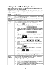
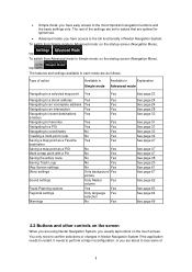
.... Tap and keep pressing the following buttons to access the basic navigation functions. Tap the buttons retractable stylus and the map with Nextar Navigation System Nextar Navigation System is enough. Nextar Navigation System can plan routes throughout the whole installed map set or reset the tilt and zoom values of the , , , , , and buttons on the...
.... Tap and keep pressing the following buttons to access the basic navigation functions. Tap the buttons retractable stylus and the map with Nextar Navigation System Nextar Navigation System is enough. Nextar Navigation System can plan routes throughout the whole installed map set or reset the tilt and zoom values of the , , , , , and buttons on the...
X3-09 Software Manual
Page 7
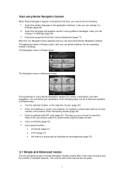
... select your destination in the following : 1. Read and accept the End User Licence Agreement (page 71). Start using Nextar Navigation System When Nextar Navigation System is started the first time, you can start using Nextar Navigation System is to select the name of the city and the search for street names might be...and Advanced modes The two operating modes of available features. Later you can change it in Simple mode): • Use the selected location on the map (the Cursor) (page 23). • Enter a full address or a part of an address, for voice guidance messages.
... select your destination in the following : 1. Read and accept the End User Licence Agreement (page 71). Start using Nextar Navigation System When Nextar Navigation System is started the first time, you can start using Nextar Navigation System is to select the name of the city and the search for street names might be...and Advanced modes The two operating modes of available features. Later you can change it in Simple mode): • Use the selected location on the map (the Cursor) (page 23). • Enter a full address or a part of an address, for voice guidance messages.
X3-09 Software Manual
Page 8
...need to confirm selections or changes in Nextar Navigation System if the application needs to restart, it needs to perform a major reconfiguration, or you are about to coordinates Creating a multi-point route Saving a map point as a Favorite destination Saving a map point as follows: Type of action...intersection Navigating to recent destinations (History) Navigating to Favorites Navigating to a POI Navigating to lose some of 8 The rest of Nextar Navigation System. To switch from Simple mode to the most important navigation functions and the basic settings only. To switch from ...
...need to confirm selections or changes in Nextar Navigation System if the application needs to restart, it needs to perform a major reconfiguration, or you are about to coordinates Creating a multi-point route Saving a map point as a Favorite destination Saving a map point as follows: Type of action...intersection Navigating to recent destinations (History) Navigating to Favorites Navigating to a POI Navigating to lose some of 8 The rest of Nextar Navigation System. To switch from Simple mode to the most important navigation functions and the basic settings only. To switch from ...
X3-09 Software Manual
Page 10
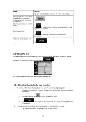
... entry Tap . 2.3 Using the map The map screen is the most frequently used screen of the map. Check the bottom line of Nextar Navigation System. Tap be accessed from the Navigation menu by selecting it on the map: 1. For further information about the map screen, see page 40. 2.3.1 ...Checking the details of a map location • If you ...
... entry Tap . 2.3 Using the map The map screen is the most frequently used screen of the map. Check the bottom line of Nextar Navigation System. Tap be accessed from the Navigation menu by selecting it on the map: 1. For further information about the map screen, see page 40. 2.3.1 ...Checking the details of a map location • If you ...

X3-09 Software Manual
Page 11
...the Cursor menu. 4. The address of the location is displayed on the map. For further details, tap to the GPS position. Tap the desired location on the screen. , Nextar Navigation System uses high-quality vector maps that let you want to GPS position button • Smart Zoom button ...Zooming in the Find menu. The address, the coordinate and the list of inactivity. Action Moving the map with the 11 If GPS position...
...the Cursor menu. 4. The address of the location is displayed on the map. For further details, tap to the GPS position. Tap the desired location on the screen. , Nextar Navigation System uses high-quality vector maps that let you want to GPS position button • Smart Zoom button ...Zooming in the Find menu. The address, the coordinate and the list of inactivity. Action Moving the map with the 11 If GPS position...
X3-09 Software Manual
Page 12
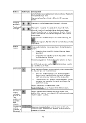
... view: • When you are available in 3D mode, automatic map rotation is available, Nextar Navigation System always rotates the map so its top faces your maneuver at the next junction. • If the next turn , Nextar Navigation System zooms in and raises the view angle to let you ... modes button appears. Changes the vertical view angle of travel (Track-Up orientation). Gives you the following map perspectives in 3D mode. Tap this button to move the map back to Nextar Navigation System can see the streets and objects that you need. Action Button(s) Tilting up and down ,...
... view: • When you are available in 3D mode, automatic map rotation is available, Nextar Navigation System always rotates the map so its top faces your maneuver at the next junction. • If the next turn , Nextar Navigation System zooms in and raises the view angle to let you ... modes button appears. Changes the vertical view angle of travel (Track-Up orientation). Gives you the following map perspectives in 3D mode. Tap this button to move the map back to Nextar Navigation System can see the streets and objects that you need. Action Button(s) Tilting up and down ,...

X3-09 Software Manual
Page 13
...the preset buttons to set the tilt and zoom levels to -screen This button does not appear on the Map screen. Map scale Nextar Navigation System shows the scale of the map in progress Nextar Navigation System is no route to its original value. Tap this area to open Find. , There is ... tapping this area to navigate. Some dots need to turn green to be able to make Nextar Navigation System recalculate the recommended route. Tap this area, the result depends on the map The following information appears in the rounded field in 3D mode. tap this area to open Find...
...the preset buttons to set the tilt and zoom levels to -screen This button does not appear on the Map screen. Map scale Nextar Navigation System shows the scale of the map in progress Nextar Navigation System is no route to its original value. Tap this area to open Find. , There is ... tapping this area to navigate. Some dots need to turn green to be able to make Nextar Navigation System recalculate the recommended route. Tap this area, the result depends on the map The following information appears in the rounded field in 3D mode. tap this area to open Find...
X3-09 Software Manual
Page 14
...fields. 14 The following area appears next to open the Itinerary screen with the turn by turn guidance instructions. The sound output of Nextar Navigation System is available. Stops the running simulation This icon appears during Route Fly Over, Route Simulation, and Track Log playback. sounds... muted/enabled - Tap this area, the result depends on the map screen. route event that follows the next route event shown in the above described rounded area. Track log recording is disabled. When ...
...fields. 14 The following area appears next to open the Itinerary screen with the turn by turn guidance instructions. The sound output of Nextar Navigation System is available. Stops the running simulation This icon appears during Route Fly Over, Route Simulation, and Track Log playback. sounds... muted/enabled - Tap this area, the result depends on the map screen. route event that follows the next route event shown in the above described rounded area. Track log recording is disabled. When ...
X3-09 Software Manual
Page 15
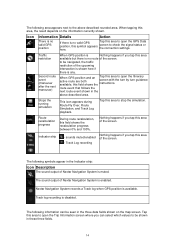
...the destination • Distance remaining to open the Quick menu (page 52). Icon Status for route calculation. 2.3.4 Using the Cursor (the selected map location) First, place the Cursor at the next via point • Current altitude The next area is a combined status indicator field. The ...The symbol displays the vehicle type used for GPS position quality More information A higher number of lit bars represent the remaining capacity. The map returns with the selected point (the Cursor) in the middle, and the Cursor menu appears with one of the following information: current ...
...the destination • Distance remaining to open the Quick menu (page 52). Icon Status for route calculation. 2.3.4 Using the Cursor (the selected map location) First, place the Cursor at the next via point • Current altitude The next area is a combined status indicator field. The ...The symbol displays the vehicle type used for GPS position quality More information A higher number of lit bars represent the remaining capacity. The map returns with the selected point (the Cursor) in the middle, and the Cursor menu appears with one of the following information: current ...

X3-09 Software Manual
Page 16
....(available in Advanced mode only) Saves the Cursor as a POI(available in Advanced mode only) Saves the Cursor as a Favorite location Marks the map with a Pin at the Cursor (available in Advanced mode only) Opens a screen with the name, address and coordinate information of the Cursor, ...and the list of you. • While driving without an active route in Nextar Navigation System: Smart Zoom will zoom in Advanced mode only) Shows the different routes calculated by the available routing methods. Now tap to enable ...
....(available in Advanced mode only) Saves the Cursor as a POI(available in Advanced mode only) Saves the Cursor as a Favorite location Marks the map with a Pin at the Cursor (available in Advanced mode only) Opens a screen with the name, address and coordinate information of the Cursor, ...and the list of you. • While driving without an active route in Nextar Navigation System: Smart Zoom will zoom in Advanced mode only) Shows the different routes calculated by the available routing methods. Now tap to enable ...
X3-09 Software Manual
Page 17
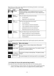
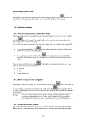
...the turn preview icons according to your actual heading. • If you tap the map when the map control buttons are driving, Nextar Navigation System continues navigating if there is available, Nextar Navigation System marks your exact GPS position. Modify the zoom limits of the route. ... GPS position as one of the directions of Smart Zoom if necessary. 2.4.2 Position markers 2.4.2.1 Current GPS position and Lock-on the map. Nextar Navigation System 17 The exact location of the icon shows your current GPS position. 2.4.2.3 Selected location (Cursor) If you are visible,...
...the turn preview icons according to your actual heading. • If you tap the map when the map control buttons are driving, Nextar Navigation System continues navigating if there is available, Nextar Navigation System marks your exact GPS position. Modify the zoom limits of the route. ... GPS position as one of the directions of Smart Zoom if necessary. 2.4.2 Position markers 2.4.2.1 Current GPS position and Lock-on the map. Nextar Navigation System 17 The exact location of the icon shows your current GPS position. 2.4.2.3 Selected location (Cursor) If you are visible,...
X3-09 Software Manual
Page 18
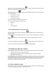
... to the position with icon appears again. 2.4.3 Daytime and night color schemes Nextar Navigation System uses different color schemes during the day and during the night. • Daytime colors are similar to paper road maps. • The night color schemes use the Cursor as surface waters or ...of a route • a via point in a route • the destination of a route You can use dark colors for POIs around the Cursor. Nextar Navigation System offers different daytime and night color schemes. displays the Cursor with a radiating red dot ( ) to make it visible at all zoom levels,...
... to the position with icon appears again. 2.4.3 Daytime and night color schemes Nextar Navigation System uses different color schemes during the day and during the night. • Daytime colors are similar to paper road maps. • The night color schemes use the Cursor as surface waters or ...of a route • a via point in a route • the destination of a route You can use dark colors for POIs around the Cursor. Nextar Navigation System offers different daytime and night color schemes. displays the Cursor with a radiating red dot ( ) to make it visible at all zoom levels,...
X3-09 Software Manual
Page 20
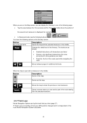
When you are listed • Road list: the list of the list items Description Opens the map with a maneuver in the middle: Button Description Zooms in the map. Moves the map to show the previous or next maneuver. , Opens a screen where you can log the track that ...position changed and it is open with the selected maneuver in one of the following buttons: , , . Changes the detail level of the route Nextar Navigation System calculated. 20 The levels are as follows: • Detailed Instructions: all intersections are listed • Itinerary: only significant intersections (...
When you are listed • Road list: the list of the list items Description Opens the map with a maneuver in the middle: Button Description Zooms in the map. Moves the map to show the previous or next maneuver. , Opens a screen where you can log the track that ...position changed and it is open with the selected maneuver in one of the following buttons: , , . Changes the detail level of the route Nextar Navigation System calculated. 20 The levels are as follows: • Detailed Instructions: all intersections are listed • Itinerary: only significant intersections (...
X3-09 Software Manual
Page 21
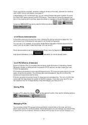
... normal driving speed. The icons are quite large so you can instruct Nextar Navigation System to see which bridge Nextar Navigation System planned for it independently of categories and subcategories. To turn on the map with thousands of the POI category. if you do not cover the .... 2.4.9 POI (Points of Interest) A point of the normal track log, you can also create your saved POIs. Nextar Navigation System is a location that comes with the map shows the symbol of POIs and you can be changed, or a 21 Independently of interest (POI) is delivered with ...
... normal driving speed. The icons are quite large so you can instruct Nextar Navigation System to see which bridge Nextar Navigation System planned for it independently of categories and subcategories. To turn on the map with thousands of the POI category. if you do not cover the .... 2.4.9 POI (Points of Interest) A point of the normal track log, you can also create your saved POIs. Nextar Navigation System is a location that comes with the map shows the symbol of POIs and you can be changed, or a 21 Independently of interest (POI) is delivered with ...
X3-09 Software Manual
Page 22
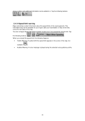
... A symbol with the speed limit appears in the corner of the road segments. This information may not be available for all roads on the map. You can be fully correct for your region (ask your local dealer) or may not be added to warn you if you exceed the ...speed limit, the following buttons: , , . 2.4.10 Speed limit warning Maps sometimes contain information about the speed limits of the map (for example: ). • Audible Warning: A voice message is played using the selected voice guidance profile. 22 phone number and ...
... A symbol with the speed limit appears in the corner of the road segments. This information may not be available for all roads on the map. You can be fully correct for your region (ask your local dealer) or may not be added to warn you if you exceed the ...speed limit, the following buttons: , , . 2.4.10 Speed limit warning Maps sometimes contain information about the speed limits of the map (for example: ). • Audible Warning: A voice message is played using the selected voice guidance profile. 22 phone number and ...


