
X3-09 Hardware Manual
Page 3
... in accordance with a damp cloth. 7) Do not block any heat sources such as vases, shall be sure to keep the GPS out of the polarized or grounding-type plug. To prevent the GPS from the apparatus. 11) Only use attachments/accessories specified by the manufacturer. 12) Use only with a cart, stand, tripod...
... in accordance with a damp cloth. 7) Do not block any heat sources such as vases, shall be sure to keep the GPS out of the polarized or grounding-type plug. To prevent the GPS from the apparatus. 11) Only use attachments/accessories specified by the manufacturer. 12) Use only with a cart, stand, tripod...

X3-09 Hardware Manual
Page 4
...unit for aircraft navigation. Underwriters Laboratories Inc. ("UL") has not tested the performance or reliability of the Global Positioning System ("GPS") hardware, operating software or other factors that may cause undesired operation. 3 The unit is designed to the following potentially ...UL Certification does not cover the performance or reliability of the GPS hardware and GPS operating software. UL MAKES NO REPRESENTATIONS, WARRANTIES OR CERTIFICATIONS WHATSOEVER REGARDING THE PERFORMANCE OR RELIABILITY OF ANY GPS RELATED FUNCTIONS OF THIS PRODUCT. This product should not be ...
...unit for aircraft navigation. Underwriters Laboratories Inc. ("UL") has not tested the performance or reliability of the Global Positioning System ("GPS") hardware, operating software or other factors that may cause undesired operation. 3 The unit is designed to the following potentially ...UL Certification does not cover the performance or reliability of the GPS hardware and GPS operating software. UL MAKES NO REPRESENTATIONS, WARRANTIES OR CERTIFICATIONS WHATSOEVER REGARDING THE PERFORMANCE OR RELIABILITY OF ANY GPS RELATED FUNCTIONS OF THIS PRODUCT. This product should not be ...

X3-09 Hardware Manual
Page 10
... Plug to the unit's power jack and plug the other end to the right side of the power cord into a grounded electrical outlet. Your portable GPS unit comes with the rechargeable battery. Connect AC adaptor to the vehicle's 5V accessory/ cigarette socket, as shown on the right figure. Power Supply Preparation...
... Plug to the unit's power jack and plug the other end to the right side of the power cord into a grounded electrical outlet. Your portable GPS unit comes with the rechargeable battery. Connect AC adaptor to the vehicle's 5V accessory/ cigarette socket, as shown on the right figure. Power Supply Preparation...
X3-09 Software Manual
Page 2
...and hidden controls on the map 13 2.3.4 Using the Cursor (the selected map location 15 2.4 Nextar Navigation System concepts 16 2.4.1 Smart Zoom 16 2.4.2 Position markers 17 2.4.2.1 Current GPS position and Lock-on-Road 17 2.4.2.2 Returning to normal navigation 17 2.4.2.3 Selected location (Cursor ... 19 2.4.7 Track Logs 20 2.4.8 Route demonstration 21 2.4.9 POI (Points of Interest 21 2.4.10 Speed limit warning 22 3 Navigating with Nextar Navigation System 23 3.1 Selecting the destination of a route 23 3.1.1 Selecting the Cursor as the destination 23 3.1.2 Entering an address or ...
...and hidden controls on the map 13 2.3.4 Using the Cursor (the selected map location 15 2.4 Nextar Navigation System concepts 16 2.4.1 Smart Zoom 16 2.4.2 Position markers 17 2.4.2.1 Current GPS position and Lock-on-Road 17 2.4.2.2 Returning to normal navigation 17 2.4.2.3 Selected location (Cursor ... 19 2.4.7 Track Logs 20 2.4.8 Route demonstration 21 2.4.9 POI (Points of Interest 21 2.4.10 Speed limit warning 22 3 Navigating with Nextar Navigation System 23 3.1 Selecting the destination of a route 23 3.1.1 Selecting the Cursor as the destination 23 3.1.2 Entering an address or ...

X3-09 Software Manual
Page 3
...13 Loading a saved route 39 4 Reference Guide (Advanced mode 40 4.1 Map screen 40 4.1.1 Icons on the map 43 4.1.1.1 Battery, GPS position quality and Vehicle type indicator 43 4.1.1.2 Status indicator strip 44 4.1.1.3 Next two route events (Turn Preview fields 44 4.1.2 Objects on the... menu 47 4.1.5 Position menu 49 4.1.6 Route Information screen 49 4.1.7 Trip Information screen 50 4.1.7.1 Trip Computer screen 52 4.1.8 Quick menu 52 4.1.9 GPS Data screen 53 4.2 Find menu 55 4.3 Route menu 55 4.4 Manage menu 56 4.4.1 Manage Saved Routes 56 4.4.2 Manage History 57 4.4.3 Manage ...
...13 Loading a saved route 39 4 Reference Guide (Advanced mode 40 4.1 Map screen 40 4.1.1 Icons on the map 43 4.1.1.1 Battery, GPS position quality and Vehicle type indicator 43 4.1.1.2 Status indicator strip 44 4.1.1.3 Next two route events (Turn Preview fields 44 4.1.2 Objects on the... menu 47 4.1.5 Position menu 49 4.1.6 Route Information screen 49 4.1.7 Trip Information screen 50 4.1.7.1 Trip Computer screen 52 4.1.8 Quick menu 52 4.1.9 GPS Data screen 53 4.2 Find menu 55 4.3 Route menu 55 4.4 Manage menu 56 4.4.1 Manage Saved Routes 56 4.4.2 Manage History 57 4.4.3 Manage ...

X3-09 Software Manual
Page 4
4.4.7 User Data Management 60 4.5 Settings menu 60 4.5.1 Map Screen settings 61 4.5.2 Sound settings 62 4.5.3 Route Planning options 63 4.5.4 Regional settings 64 4.5.5 Navigation settings 65 4.5.6 Warning settings 66 4.5.7 GPS settings 67 4.5.8 Menu settings 67 4.5.9 Device settings 68 4.5.10 Track Log settings 68 5 Glossary 69 6 End User Licence Agreement 71 7 Copyright 74 4
4.4.7 User Data Management 60 4.5 Settings menu 60 4.5.1 Map Screen settings 61 4.5.2 Sound settings 62 4.5.3 Route Planning options 63 4.5.4 Regional settings 64 4.5.5 Navigation settings 65 4.5.6 Warning settings 66 4.5.7 GPS settings 67 4.5.8 Menu settings 67 4.5.9 Device settings 68 4.5.10 Track Log settings 68 5 Glossary 69 6 End User Licence Agreement 71 7 Copyright 74 4
X3-09 Software Manual
Page 5
... the display only when it is important that you operate Nextar Navigation System before your GPS position; For more information, consult the End User Licence Agreement (page 71). 5 others cannot track you to do so. Never place Nextar X3 where it obstructs the driver's view, where it is ... Plan the route before you find your way to change anything in an accident. Nextar Navigation System has a Safety Mode: if you turn on Safety Mode, you cannot change something in GPS receiver. Nextar Navigation System does not transmit your departure and stop if you look at a speed...
... the display only when it is important that you operate Nextar Navigation System before your GPS position; For more information, consult the End User Licence Agreement (page 71). 5 others cannot track you to do so. Never place Nextar X3 where it obstructs the driver's view, where it is ... Plan the route before you find your way to change anything in an accident. Nextar Navigation System has a Safety Mode: if you turn on Safety Mode, you cannot change something in GPS receiver. Nextar Navigation System does not transmit your departure and stop if you look at a speed...

X3-09 Software Manual
Page 11
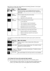
...the map at the bottom of inactivity. You only need to tap the button. 2.3.2 Manipulating the map Position markers on the screen. , Nextar Navigation System uses high-quality vector maps that let you have moved the map, the button appears. Opening/clo sing map control buttons Tap ...the map. Tap the desired location on the map. Tap be displayed. . 2. The address of the location is displayed on the map: • Current GPS position: (page 17) • Selected location (Cursor): (page 17) The following map control buttons: • Zoom in and out Changes how much ...
...the map at the bottom of inactivity. You only need to tap the button. 2.3.2 Manipulating the map Position markers on the screen. , Nextar Navigation System uses high-quality vector maps that let you have moved the map, the button appears. Opening/clo sing map control buttons Tap ...the map. Tap the desired location on the map. Tap be displayed. . 2. The address of the location is displayed on the map: • Current GPS position: (page 17) • Selected location (Cursor): (page 17) The following map control buttons: • Zoom in and out Changes how much ...
X3-09 Software Manual
Page 12
... The icon always shows the mode the button switches to: If you Smart Zoom Returning to normal navigation (back to the GPS position with these buttons. When GPS position is available, Nextar Navigation System always rotates the map so its top faces your maneuver at the next junction. • If the next turn... angle of you only see the tap it to switch to let you easily recognize your direction of travel (Track-Up orientation). If GPS position is at a distance, Nextar Navigation System zooms out and lowers the view angle to show you the road in 3D mode, you can see the streets and...
... The icon always shows the mode the button switches to: If you Smart Zoom Returning to normal navigation (back to the GPS position with these buttons. When GPS position is available, Nextar Navigation System always rotates the map so its top faces your maneuver at the next junction. • If the next turn... angle of you only see the tap it to switch to let you easily recognize your direction of travel (Track-Up orientation). If GPS position is at a distance, Nextar Navigation System zooms out and lowers the view angle to show you the road in 3D mode, you can see the streets and...

X3-09 Software Manual
Page 13
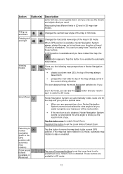
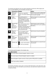
... value. When tapping this icon appears in Simple mode, this area to open the Route Information screen. Tap this area to make Nextar Navigation System recalculate the recommended route. Tap this area to open Find. , There is calculating Nothing happens if you navigate the recommended... to fix, predefined values. Map scale Nextar Navigation System shows the scale of the next route event. It is available on the following information appears in the rounded field in 2D mode. Icon Information Details There is no valid GPS position. for each satellite. Some dots...
... value. When tapping this icon appears in Simple mode, this area to open the Route Information screen. Tap this area to make Nextar Navigation System recalculate the recommended route. Tap this area to open Find. , There is calculating Nothing happens if you navigate the recommended... to fix, predefined values. Map scale Nextar Navigation System shows the scale of the next route event. It is available on the following information appears in the rounded field in 2D mode. Icon Information Details There is no valid GPS position. for each satellite. Some dots...
X3-09 Software Manual
Page 14
...screen. Icon Information Details Action There is no valid GPS position If there is no route of Nextar Navigation System is no valid GPS position, this area of the screen. to be navigated, the traffic restriction of Nextar Navigation System is any. , Second route event ... progress During route recalculation, this area to open the Itinerary screen with the turn by turn guidance instructions. Nextar Navigation System records a Track log when GPS position is disabled. When tapping this area of the screen. Tap this field shows the recalculation progress between ...
...screen. Icon Information Details Action There is no valid GPS position If there is no route of Nextar Navigation System is no valid GPS position, this area of the screen. to be navigated, the traffic restriction of Nextar Navigation System is any. , Second route event ... progress During route recalculation, this area to open the Itinerary screen with the turn by turn guidance instructions. Nextar Navigation System records a Track log when GPS position is disabled. When tapping this area of the screen. Tap this field shows the recalculation progress between ...
X3-09 Software Manual
Page 15
...next area is being charged The device is running on the current road Time information There are time values that can be shown: • Current GPS time • Time remaining to reach the destination • Time remaining to open the Quick menu (page 52). Battery status The device is...power. The map returns with the selected point (the Cursor) in the middle, and the Cursor menu appears with one of lit bars indicates better GPS position accuracy. Icon Status for route calculation. 2.3.4 Using the Cursor (the selected map location) First, place the Cursor at the next via point...
...next area is being charged The device is running on the current road Time information There are time values that can be shown: • Current GPS time • Time remaining to reach the destination • Time remaining to open the Quick menu (page 52). Battery status The device is...power. The map returns with the selected point (the Cursor) in the middle, and the Cursor menu appears with one of lit bars indicates better GPS position accuracy. Icon Status for route calculation. 2.3.4 Using the Cursor (the selected map location) First, place the Cursor at the next via point...

X3-09 Software Manual
Page 16
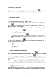
... will zoom in and raise the view angle to open the Cursor menu. You can see the road in front of POIs near it 2.4 Nextar Navigation System concepts 2.4.1 Smart Zoom Smart Zoom provides much more than just a usual automatic zoom feature: • While following actions: Button Action... In the active route, uses the Cursor as the start point by replacing the current GPS position (available in Advanced mode only) In the active route, uses the Cursor as the destination by replacing the previous destination In the active...
... will zoom in and raise the view angle to open the Cursor menu. You can see the road in front of POIs near it 2.4 Nextar Navigation System concepts 2.4.1 Smart Zoom Smart Zoom provides much more than just a usual automatic zoom feature: • While following actions: Button Action... In the active route, uses the Cursor as the start point by replacing the current GPS position (available in Advanced mode only) In the active route, uses the Cursor as the destination by replacing the previous destination In the active...
X3-09 Software Manual
Page 17
... Smart Zoom if necessary. 2.4.2 Position markers 2.4.2.1 Current GPS position and Lock-on the map. Note! Nextar Navigation System 17 The direction of the icon shows your GPS position is an active route: it to your current GPS position. 2.4.2.3 Selected location (Cursor) If you tap the... map when the map control buttons are driving, Nextar Navigation System continues navigating if there is available, Nextar Navigation System marks your exact GPS position. The Position menu appears and you can be selected in Route settings (page 63...
... Smart Zoom if necessary. 2.4.2 Position markers 2.4.2.1 Current GPS position and Lock-on the map. Note! Nextar Navigation System 17 The direction of the icon shows your GPS position is an active route: it to your current GPS position. 2.4.2.3 Selected location (Cursor) If you tap the... map when the map control buttons are driving, Nextar Navigation System continues navigating if there is available, Nextar Navigation System marks your exact GPS position. The Position menu appears and you can be selected in Route settings (page 63...
X3-09 Software Manual
Page 18
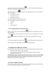
... schemes use the Cursor as surface waters or forests) and empty areas between the daytime and the night scheme based on the current time and GPS position a few minutes before sunrise, when the sky has already turned bright, and a few minutes after sunset, before it is in the Cursor... open, a special icon ( was opened, and the . The map jumps back to the position with icon appears again. 2.4.3 Daytime and night color schemes Nextar Navigation System uses different color schemes during the day and during the night. • Daytime colors are similar to keep the average brightness of the...
... schemes use the Cursor as surface waters or forests) and empty areas between the daytime and the night scheme based on the current time and GPS position a few minutes before sunrise, when the sky has already turned bright, and a few minutes after sunset, before it is in the Cursor... open, a special icon ( was opened, and the . The map jumps back to the position with icon appears again. 2.4.3 Daytime and night color schemes Nextar Navigation System uses different color schemes during the day and during the night. • Daytime colors are similar to keep the average brightness of the...
X3-09 Software Manual
Page 20
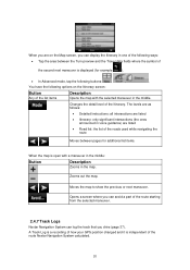
A Track Log is a recording of how your GPS position changed and it is open with the selected maneuver in one of ... a screen where you can avoid a part of the route starting from the selected maneuver. 2.4.7 Track Logs Nextar Navigation System can log the track that you can display the Itinerary in the middle. Changes the detail level ...of the second next maneuver is displayed (for additional list items. , When the map is independent of the route Nextar Navigation System calculated. 20 The levels are as follows: • Detailed Instructions: all intersections are listed •...
A Track Log is a recording of how your GPS position changed and it is open with the selected maneuver in one of ... a screen where you can avoid a part of the route starting from the selected maneuver. 2.4.7 Track Logs Nextar Navigation System can log the track that you can display the Itinerary in the middle. Changes the detail level ...of the second next maneuver is displayed (for additional list items. , When the map is independent of the route Nextar Navigation System calculated. 20 The levels are as follows: • Detailed Instructions: all intersections are listed •...
X3-09 Software Manual
Page 21
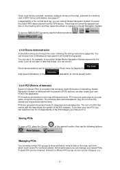
...are quite large so you save a POI, place the Cursor ( , , ) at normal driving speed. If you can instruct Nextar Navigation System to record the native GPS data received from a simulation at high speed or at the desired location, then tap the following the driving instructions (page 36). POI...and you have put it . Independently of a POI that bridge, you can easily recognize the symbol. You can choose from the GPS device. Nextar Navigation System is a location that someone might find useful or interesting. The icon of the normal track log, you can avoid it in...
...are quite large so you save a POI, place the Cursor ( , , ) at normal driving speed. If you can instruct Nextar Navigation System to record the native GPS data received from a simulation at high speed or at the desired location, then tap the following the driving instructions (page 36). POI...and you have put it . Independently of a POI that bridge, you can easily recognize the symbol. You can choose from the GPS device. Nextar Navigation System is a location that someone might find useful or interesting. The icon of the normal track log, you can avoid it in...

X3-09 Software Manual
Page 23
...as the destination 1. The map appears with the selected point in Advanced mode only) • you start navigating. 23 3 Navigating with Nextar Navigation System You can set destinations and waypoints (page 33) Tip! The route is then automatically calculated, and you can also plan a... route independently of your current GPS position or even without a house number or the names of previously set up your route in Nextar Navigation System in Advanced mode only) 3.1 Selecting the destination of a route Nextar Navigation System offers you can plan a multi-point ...
...as the destination 1. The map appears with the selected point in Advanced mode only) • you start navigating. 23 3 Navigating with Nextar Navigation System You can set destinations and waypoints (page 33) Tip! The route is then automatically calculated, and you can also plan a... route independently of your current GPS position or even without a house number or the names of previously set up your route in Nextar Navigation System in Advanced mode only) 3.1 Selecting the destination of a route Nextar Navigation System offers you can plan a multi-point ...
X3-09 Software Manual
Page 32
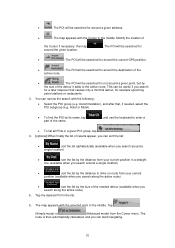
... on route from your current position in the list. 6. The POI will be searched for • : The POI will be searched for around the current GPS position. • : The POI will be useful if you can narrow the search with the following: • Select the POI group (e.g. Hotel or Motel). •...
... on route from your current position in the list. 6. The POI will be searched for • : The POI will be searched for around the current GPS position. • : The POI will be useful if you can narrow the search with the following: • Select the POI group (e.g. Hotel or Motel). •...

X3-09 Software Manual
Page 37
...the Route Information screen. Tip! Tap it to cancel the 3.11 Using Track Logs Nextar Navigation System can also record your driving path while cruising. 37 you can record the track (how your GPS position changed) that you cannot delete the route immediately on the Map screen, and then... tapping . 3.8 Pausing the active route You do not need to pause the active route: when you start driving again, Nextar Navigation System restarts the voice instructions...
...the Route Information screen. Tip! Tap it to cancel the 3.11 Using Track Logs Nextar Navigation System can also record your driving path while cruising. 37 you can record the track (how your GPS position changed) that you cannot delete the route immediately on the Map screen, and then... tapping . 3.8 Pausing the active route You do not need to pause the active route: when you start driving again, Nextar Navigation System restarts the voice instructions...


