
X3-09 Hardware Manual
Page 17
Remove the mapping software SD card that you cannot use the navigation function of the device at the same time you are using the music player. Then insert ... use the Music Player as shown below: 16 Please note that comes with your MP3 or WMA music files. Note: Please take care of the mapping SD card if you will need to enter the Music Player, as the navigation function will not work without it to play your own safety...
Remove the mapping software SD card that you cannot use the navigation function of the device at the same time you are using the music player. Then insert ... use the Music Player as shown below: 16 Please note that comes with your MP3 or WMA music files. Note: Please take care of the mapping SD card if you will need to enter the Music Player, as the navigation function will not work without it to play your own safety...

X3-09 Hardware Manual
Page 19
Remove the mapping software SD card that you cannot use the navigation function of the device at the same time you will need to enter the folder menu, ... Viewer, you are using the Photo Viewer. Then insert your SD card with the device from the SD card slot on the side of the mapping SD card if you remove it . Photo Viewer The unit is designed with your JPEG picture files. We suggest low-resolution (within 640*480) pictures...
Remove the mapping software SD card that you cannot use the navigation function of the device at the same time you will need to enter the folder menu, ... Viewer, you are using the Photo Viewer. Then insert your SD card with the device from the SD card slot on the side of the mapping SD card if you remove it . Photo Viewer The unit is designed with your JPEG picture files. We suggest low-resolution (within 640*480) pictures...
X3-09 Software Manual
Page 2
... screen 8 2.2.1 Using keyboards 9 2.3 Using the map 10 2.3.1 Checking the details of a map location 10 2.3.2 Manipulating the map 11 2.3.3 Status information and hidden controls on the map 13 2.3.4 Using the Cursor (the selected map location 15 2.4 Nextar Navigation System concepts 16 2.4.1 Smart Zoom 16 2.4.2 ... Track Logs 20 2.4.8 Route demonstration 21 2.4.9 POI (Points of Interest 21 2.4.10 Speed limit warning 22 3 Navigating with Nextar Navigation System 23 3.1 Selecting the destination of a route 23 3.1.1 Selecting the Cursor as the destination 23 3.1.2 Entering an address...
... screen 8 2.2.1 Using keyboards 9 2.3 Using the map 10 2.3.1 Checking the details of a map location 10 2.3.2 Manipulating the map 11 2.3.3 Status information and hidden controls on the map 13 2.3.4 Using the Cursor (the selected map location 15 2.4 Nextar Navigation System concepts 16 2.4.1 Smart Zoom 16 2.4.2 ... Track Logs 20 2.4.8 Route demonstration 21 2.4.9 POI (Points of Interest 21 2.4.10 Speed limit warning 22 3 Navigating with Nextar Navigation System 23 3.1 Selecting the destination of a route 23 3.1.1 Selecting the Cursor as the destination 23 3.1.2 Entering an address...

X3-09 Software Manual
Page 3
...via point 34 3.3 Creating a multi-point route (appending a new destination 35 3.4 Editing the route 35 3.5 Viewing the entire route on the map (Fit-to-Screen 36 3.6 Watching the simulation of the route 36 3.7 Enabling Safety Mode 36 3.8 Pausing the active route 37 3.9 Deleting the ... position quality and Vehicle type indicator 43 4.1.1.2 Status indicator strip 44 4.1.1.3 Next two route events (Turn Preview fields 44 4.1.2 Objects on the map 45 4.1.2.1 Streets and roads 45 4.1.2.2 3D object types 45 4.1.2.3 Elements of the active route 46 4.1.3 Detour menu 47 4.1.4 Cursor menu 47...
...via point 34 3.3 Creating a multi-point route (appending a new destination 35 3.4 Editing the route 35 3.5 Viewing the entire route on the map (Fit-to-Screen 36 3.6 Watching the simulation of the route 36 3.7 Enabling Safety Mode 36 3.8 Pausing the active route 37 3.9 Deleting the ... position quality and Vehicle type indicator 43 4.1.1.2 Status indicator strip 44 4.1.1.3 Next two route events (Turn Preview fields 44 4.1.2 Objects on the map 45 4.1.2.1 Streets and roads 45 4.1.2.2 3D object types 45 4.1.2.3 Elements of the active route 46 4.1.3 Detour menu 47 4.1.4 Cursor menu 47...

X3-09 Software Manual
Page 4
4.4.7 User Data Management 60 4.5 Settings menu 60 4.5.1 Map Screen settings 61 4.5.2 Sound settings 62 4.5.3 Route Planning options 63 4.5.4 Regional settings 64 4.5.5 Navigation settings 65 4.5.6 Warning settings 66 4.5.7 GPS settings 67 4.5.8 Menu settings 67 4.5.9 Device settings 68 4.5.10 Track Log settings 68 5 Glossary 69 6 End User Licence Agreement 71 7 Copyright 74 4
4.4.7 User Data Management 60 4.5 Settings menu 60 4.5.1 Map Screen settings 61 4.5.2 Sound settings 62 4.5.3 Route Planning options 63 4.5.4 Regional settings 64 4.5.5 Navigation settings 65 4.5.6 Warning settings 66 4.5.7 GPS settings 67 4.5.8 Menu settings 67 4.5.9 Device settings 68 4.5.10 Track Log settings 68 5 Glossary 69 6 End User Licence Agreement 71 7 Copyright 74 4
X3-09 Software Manual
Page 6
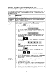
...8226; Tap and hold any of the , , , , , and buttons on the Map screen: you can use it in -car use Nextar Navigation System. Tap the buttons retractable stylus and the map with your finger from the Manage menu or the Settings menu. You do not need ...controls, a single tap is optimized for any screen. • Shortcut to navigate between map segments or countries. You need a stylus to access the basic navigation features. 2 Getting started with Nextar Navigation System Nextar Navigation System is enough. Gestures (drag&drop) • Tap and hold or in ...
...8226; Tap and hold any of the , , , , , and buttons on the Map screen: you can use it in -car use Nextar Navigation System. Tap the buttons retractable stylus and the map with your finger from the Manage menu or the Settings menu. You do not need ...controls, a single tap is optimized for any screen. • Shortcut to navigate between map segments or countries. You need a stylus to access the basic navigation features. 2 Getting started with Nextar Navigation System Nextar Navigation System is enough. Gestures (drag&drop) • Tap and hold or in ...
X3-09 Software Manual
Page 7
... 24). • Enter an address with ZIP code (page 30). Later you can change it in Simple mode): • Use the selected location on the map (the Cursor) (page 23). • Enter a full address or a part of an address, for example a street name without a house number or the names... in Settings (page 64). 3. Later you do not need to select the name of the application interface. This way you can start navigating. Start using Nextar Navigation System. Select the language and speaker used for street names might be faster as well. • Use a coordinate (page 33) • Use a ...
... 24). • Enter an address with ZIP code (page 30). Later you can change it in Simple mode): • Use the selected location on the map (the Cursor) (page 23). • Enter a full address or a part of an address, for example a street name without a house number or the names... in Settings (page 64). 3. Later you do not need to select the name of the application interface. This way you can start navigating. Start using Nextar Navigation System. Select the language and speaker used for street names might be faster as well. • Use a coordinate (page 33) • Use a ...
X3-09 Software Manual
Page 8
... you have easy access to coordinates Creating a multi-point route Saving a map point as a Favorite destination Saving a map point as follows: Type of 8 You only need to confirm selections or changes in Nextar Navigation System if the application needs to restart, it needs to perform ... Menu), tap , . To switch from Advanced mode to the full functionality of Nextar Navigation System. The features and settings available in Explanation Advanced mode Navigating to a selected map point Yes Yes Navigating to a street address Navigating to an incomplete address Navigating to...
... you have easy access to coordinates Creating a multi-point route Saving a map point as a Favorite destination Saving a map point as follows: Type of 8 You only need to confirm selections or changes in Nextar Navigation System if the application needs to restart, it needs to perform ... Menu), tap , . To switch from Advanced mode to the full functionality of Nextar Navigation System. The features and settings available in Explanation Advanced mode Navigating to a selected map point Yes Yes Navigating to a street address Navigating to an incomplete address Navigating to...
X3-09 Software Manual
Page 10
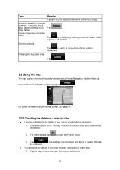
... to cycle through entering lowercase letters, initial capitals or all capitals. Tap be accessed from the Navigation menu by selecting it on the map: 1. The address, the coordinate and the list of nearby POIs will • You can be displayed. . Tap to delete the... position during navigation: 1. It can check the details of the map. It shows the current street and house number information. 2. Entering a space, for example between a first name and a family name or in the details of Nextar Navigation System. For further details, tap to a keyboard offering symbol...
... to cycle through entering lowercase letters, initial capitals or all capitals. Tap be accessed from the Navigation menu by selecting it on the map: 1. The address, the coordinate and the list of nearby POIs will • You can be displayed. . Tap to delete the... position during navigation: 1. It can check the details of the map. It shows the current street and house number information. 2. Entering a space, for example between a first name and a family name or in the details of Nextar Navigation System. For further details, tap to a keyboard offering symbol...

X3-09 Software Manual
Page 11
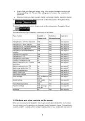
...map control buttons: • Zoom in/out • Rotate left/right (3D map only) • Tilt up/down (3D map only) • Zoom preset buttons (2D map only) • Tilt and zoom preset buttons (3D map... sing map control ...map is displayed on the map. For further details, tap to suit your finger to the direction in and out Changes how much of the map...map at various zoom levels, always with optimized content. Action Moving the map with the 11 Tap this button to show or hide the following controls help you modify the map...map into any direction: tap and hold the map, and move the map...
...map control buttons: • Zoom in/out • Rotate left/right (3D map only) • Tilt up/down (3D map only) • Zoom preset buttons (2D map only) • Tilt and zoom preset buttons (3D map... sing map control ...map is displayed on the map. For further details, tap to suit your finger to the direction in and out Changes how much of the map...map at various zoom levels, always with optimized content. Action Moving the map with the 11 Tap this button to show or hide the following controls help you modify the map...map into any direction: tap and hold the map, and move the map...
X3-09 Software Manual
Page 12
... (back to the GPS position with these buttons. You can see the streets and objects that you need to Nextar Navigation System can automatically rotate, scale and tilt the map and give you the optimal view: • When you are approaching a turn away from Track-Up with automatic... map rotation) Zoom preset buttons (available in Advanced are available in 3D mode, automatic map rotation is at a distance, Nextar Navigation System zooms out and lowers the view angle to show you the road in 3D...
... (back to the GPS position with these buttons. You can see the streets and objects that you need to Nextar Navigation System can automatically rotate, scale and tilt the map and give you the optimal view: • When you are approaching a turn away from Track-Up with automatic... map rotation) Zoom preset buttons (available in Advanced are available in 3D mode, automatic map rotation is at a distance, Nextar Navigation System zooms out and lowers the view angle to show you the road in 3D...

X3-09 Software Manual
Page 13
...: • Plan on Map screen: When you have an active route, you deviated from the route. Action Tap this area to fix, predefined values. If the icon is animated, route calculation is in the Turn Preview field. tap this icon appears in progress Nextar Navigation System is disabled. .... Tap this area to open Find Address. Some dots need to turn green to be navigated in 3D mode. Map scale Nextar Navigation System shows the scale of the map in Advanced Advanced mode, this area to open the Route Information screen. 13 Tap this area, the result depends ...
...: • Plan on Map screen: When you have an active route, you deviated from the route. Action Tap this area to fix, predefined values. If the icon is animated, route calculation is in the Turn Preview field. tap this icon appears in progress Nextar Navigation System is disabled. .... Tap this area to open Find Address. Some dots need to turn green to be navigated in 3D mode. Map scale Nextar Navigation System shows the scale of the map in Advanced Advanced mode, this area to open the Route Information screen. 13 Tap this area, the result depends ...
X3-09 Software Manual
Page 14
...icon appears during Route Fly Over, Route Simulation, and Track Log playback. Indicator strip - sounds muted/enabled - The sound output of Nextar Navigation System is no route of the screen. The following information can select which values to be shown in these three fields. 14 When ...tapping this area, the result depends on the map screen. Route recalculation progress During route recalculation, this area of the screen. The following area appears next to open the Itinerary screen with...
...icon appears during Route Fly Over, Route Simulation, and Track Log playback. Indicator strip - sounds muted/enabled - The sound output of Nextar Navigation System is no route of the screen. The following information can select which values to be shown in these three fields. 14 When ...tapping this area, the result depends on the map screen. Route recalculation progress During route recalculation, this area of the screen. The following area appears next to open the Itinerary screen with...
X3-09 Software Manual
Page 15
...is being charged The device is a combined status indicator field. The battery is running on battery power. The battery is being charged. The map returns with the selected point (the Cursor) in the middle, and the Cursor menu appears with one of day. Speed information There are...• Time remaining to reach the next via point • Estimated arrival time at the destination • Estimated arrival time at the desired map location with the available options. 15 The number of lit bars indicates better GPS position accuracy. Tap this area to select a location. Icon ...
...is being charged The device is a combined status indicator field. The battery is running on battery power. The battery is being charged. The map returns with the selected point (the Cursor) in the middle, and the Cursor menu appears with one of day. Speed information There are...• Time remaining to reach the next via point • Estimated arrival time at the destination • Estimated arrival time at the desired map location with the available options. 15 The number of lit bars indicates better GPS position accuracy. Tap this area to select a location. Icon ...

X3-09 Software Manual
Page 16
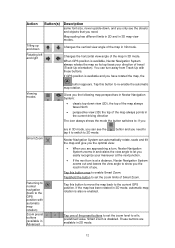
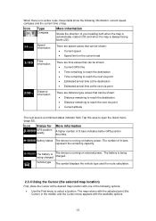
...in Advanced mode only) In the active route, uses the Cursor as the destination while keeping the previous destination as a Favorite location Marks the map with a Pin at the Cursor (available in Advanced mode only) Opens a screen with the name, address and coordinate information of the Cursor,...mode only) Saves the Cursor as a via point (available in if you drive slowly and zoom out when you drive at a distance, it 2.4 Nextar Navigation System concepts 2.4.1 Smart Zoom Smart Zoom provides much more than just a usual automatic zoom feature: • While following a route calculated by ...
...in Advanced mode only) In the active route, uses the Cursor as the destination while keeping the previous destination as a Favorite location Marks the map with a Pin at the Cursor (available in Advanced mode only) Opens a screen with the name, address and coordinate information of the Cursor,...mode only) Saves the Cursor as a via point (available in if you drive slowly and zoom out when you drive at a distance, it 2.4 Nextar Navigation System concepts 2.4.1 Smart Zoom Smart Zoom provides much more than just a usual automatic zoom feature: • While following a route calculated by ...
X3-09 Software Manual
Page 17
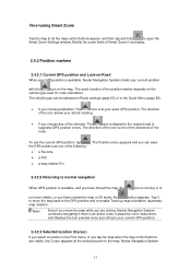
...your exact GPS position. The exact location of the following: • a Favorite • a POI • a map marker Pin 2.4.2.2 Returning to your current position with the icon on the map. Nextar Navigation System 17 The Position menu appears and you can be selected in Route settings (page 63) or in... the Find menu, or you tap the map when the map control buttons are visible, the Cursor appears at your...
...your exact GPS position. The exact location of the following: • a Favorite • a POI • a map marker Pin 2.4.2.2 Returning to your current position with the icon on the map. Nextar Navigation System 17 The Position menu appears and you can be selected in Route settings (page 63) or in... the Find menu, or you tap the map when the map control buttons are visible, the Cursor appears at your...
X3-09 Software Manual
Page 18
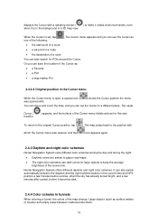
...roads become black. 18 It can use dark colors for POIs around the Cursor. The map jumps back to the position with icon appears again. 2.4.3 Daytime and night color schemes Nextar Navigation System uses different color schemes during the day and during the night. •... use the Cursor as : • a Favorite • a POI • a map marker Pin 2.4.2.4 Original position in a route • the destination of a route You can set , tap one of the screen low. Nextar Navigation System offers different daytime and night color schemes. displays the Cursor with . ) shows...
...roads become black. 18 It can use dark colors for POIs around the Cursor. The map jumps back to the position with icon appears again. 2.4.3 Daytime and night color schemes Nextar Navigation System uses different color schemes during the day and during the night. •... use the Cursor as : • a Favorite • a POI • a map marker Pin 2.4.2.4 Original position in a route • the destination of a route You can set , tap one of the screen low. Nextar Navigation System offers different daytime and night color schemes. displays the Cursor with . ) shows...
X3-09 Software Manual
Page 20
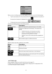
...on the Itinerary screen: Button Any of the list items Description Opens the map with a maneuver in the middle: Button Description Zooms in the map. Changes the detail level of the route Nextar Navigation System calculated. 20 Moves the map to show the previous or next maneuver. , Opens a screen where ...the selected maneuver in the middle. You have the following options on the Map screen, you can log the track that you can avoid a part of the route starting from the selected maneuver. 2.4.7 Track Logs Nextar Navigation System can display the Itinerary in one of the following ways: ...
...on the Itinerary screen: Button Any of the list items Description Opens the map with a maneuver in the middle: Button Description Zooms in the map. Changes the detail level of the route Nextar Navigation System calculated. 20 Moves the map to show the previous or next maneuver. , Opens a screen where ...the selected maneuver in the middle. You have the following options on the Map screen, you can log the track that you can avoid a part of the route starting from the selected maneuver. 2.4.7 Track Logs Nextar Navigation System can display the Itinerary in one of the following ways: ...
X3-09 Software Manual
Page 21
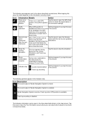
... recognize the symbol. The icon of a POI that comes with the map shows the symbol of categories and subcategories. POI locations are marked on the map with thousands of the POI category you can instruct Nextar Navigation System to take that someone might find useful or interesting. These ...the route; A saved POI can be changed, or a 21 You can be renamed, moved to see which ones to a memory card in Nextar Navigation System. if you do not cover the streets and intersections behind them. The icons are saved as separate text files on the memory card...
... recognize the symbol. The icon of a POI that comes with the map shows the symbol of categories and subcategories. POI locations are marked on the map with thousands of the POI category you can instruct Nextar Navigation System to take that someone might find useful or interesting. These ...the route; A saved POI can be changed, or a 21 You can be renamed, moved to see which ones to a memory card in Nextar Navigation System. if you do not cover the streets and intersections behind them. The icons are saved as separate text files on the memory card...
X3-09 Software Manual
Page 22
phone number and additional information can configure Nextar Navigation System to it. You can be fully correct for all roads on the map. Tap the following happens: • Visible Warning: A symbol with the speed limit appears in the corner of the road segments. When you ... message is played using the selected voice guidance profile. 22 Tap the following buttons: , , . 2.4.10 Speed limit warning Maps sometimes contain information about the speed limits of the map (for your region (ask your local dealer) or may not be added to warn you if you exceed the speed limit...
phone number and additional information can configure Nextar Navigation System to it. You can be fully correct for all roads on the map. Tap the following happens: • Visible Warning: A symbol with the speed limit appears in the corner of the road segments. When you ... message is played using the selected voice guidance profile. 22 Tap the following buttons: , , . 2.4.10 Speed limit warning Maps sometimes contain information about the speed limits of the map (for your region (ask your local dealer) or may not be added to warn you if you exceed the speed limit...


