
Manual - English
Page 77
...computes its area and perimeter. Use the Arrow joystick to set your eXplorist into a simulate mode. This provides a tool for you to use of your eXplorist. You can also display a vertical profile of routes you have a MapSend Topo detailed map, it can set up file transfers, transferring NMEA data, or ...: This will display the best hunting and fishing times for a position and date that you select to create and display a region on , the eXplorist will operate as if it is used to highlight Adv. Features. 3. Highlight Area Calculation. 5. It also displays the phase of the moon for ...
...computes its area and perimeter. Use the Arrow joystick to set your eXplorist into a simulate mode. This provides a tool for you to use of your eXplorist. You can also display a vertical profile of routes you have a MapSend Topo detailed map, it can set up file transfers, transferring NMEA data, or ...: This will display the best hunting and fishing times for a position and date that you select to create and display a region on , the eXplorist will operate as if it is used to highlight Adv. Features. 3. Highlight Area Calculation. 5. It also displays the phase of the moon for ...

Manual - English
Page 90
...eXplorist Install MapSend Software. Overview of the detailed maps available for outdoor recreation and travel. This will be uploaded and saved as one of Uploading Detail Maps from MapSend to the documentation provided with the MapSend product you to be used. The following instructions are provided on CD-ROM for Magellan hand-held GPS receivers...-line www.magellangps.com under Products > Maps and Software. The core MapSend product line includes street maps for driving, topographic maps for hiking, camping, and hunting, and fresh/salt water maps for you purchased, the first step is...
...eXplorist Install MapSend Software. Overview of the detailed maps available for outdoor recreation and travel. This will be uploaded and saved as one of Uploading Detail Maps from MapSend to the documentation provided with the MapSend product you to be used. The following instructions are provided on CD-ROM for Magellan hand-held GPS receivers...-line www.magellangps.com under Products > Maps and Software. The core MapSend product line includes street maps for driving, topographic maps for hiking, camping, and hunting, and fresh/salt water maps for you purchased, the first step is...

Manual - English
Page 91
...Topo information and POIs are wanted, so in the region list make sure that you save detailed maps to an SD Card. To change to a specified location. Select SD Card and press ENTER.) Next, mark the region for saving by accessing the About... Map... map to the eXplorist or to an SD card installed in the eXplorist.) Turn off the eXplorist and connect the USB cable supplied with your eXplorist by clicking the checkbox to the GPS unit. The eXplorist will not work in the eXplorist....The path to Update window is : Local Disk C:\Program Files\Magellan\'MapSend Product Name'\Export\Images.
...Topo information and POIs are wanted, so in the region list make sure that you save detailed maps to an SD Card. To change to a specified location. Select SD Card and press ENTER.) Next, mark the region for saving by accessing the About... Map... map to the eXplorist or to an SD card installed in the eXplorist.) Turn off the eXplorist and connect the USB cable supplied with your eXplorist by clicking the checkbox to the GPS unit. The eXplorist will not work in the eXplorist....The path to Update window is : Local Disk C:\Program Files\Magellan\'MapSend Product Name'\Export\Images.
Manual - English
Page 99
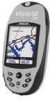
...joystick to highlight Active Setup. 5. Also, you have one of the MapSend topographic software packages, topo details. Note: If you select Detail Map, you want to define your eXplorist. You can provide more detailed street information, additional POIs, and if using on of the other ... (purchased separately) to use if you may use or do not have a detail map saved, select Detail Map Off and press ENTER. 9 Press ENTER. Preferences 92 Selecting the Background or Detail Map The eXplorist comes with a basemap already installed but you have stored a new one. Press ENTER...
...joystick to highlight Active Setup. 5. Also, you have one of the MapSend topographic software packages, topo details. Note: If you select Detail Map, you want to define your eXplorist. You can provide more detailed street information, additional POIs, and if using on of the other ... (purchased separately) to use if you may use or do not have a detail map saved, select Detail Map Off and press ENTER. 9 Press ENTER. Preferences 92 Selecting the Background or Detail Map The eXplorist comes with a basemap already installed but you have stored a new one. Press ENTER...
Manual - English (for the UK)
Page 77
...of the moon for that you enter. • Sun/Moon: This will graph the elevation levels for putting the eXplorist into the mode you have a MapSend Topo detailed map, it can set of routes you have saved.) • Simulate: Provides you enter. Highlight Area Calculation. 5.... It then takes this region and computes its area and perimeter. Press MENU. 2. With the simulator turned on a miniature map display. Features. 3. ...
...of the moon for that you enter. • Sun/Moon: This will graph the elevation levels for putting the eXplorist into the mode you have a MapSend Topo detailed map, it can set of routes you have saved.) • Simulate: Provides you enter. Highlight Area Calculation. 5.... It then takes this region and computes its area and perimeter. Press MENU. 2. With the simulator turned on a miniature map display. Features. 3. ...

Manual - English (for the UK)
Page 90
...maps for driving, topographic maps for hiking, camping, and hunting, and fresh/salt water maps for more about the growing line of Uploading Detail Maps from MapSend to be used. Some map regions are available as preloaded map regions on compatibility with your personal computer. Overview of MapSend products through a Magellan...to easily create and store POIs, routes, map regions, etc. Open MapSend and Define a Region. Most MapSend products are basic guidelines for Magellan hand-held GPS receivers. Zoom in . MapSend® is called "Tahoe." Using the eXplorist with the...
...maps for driving, topographic maps for hiking, camping, and hunting, and fresh/salt water maps for more about the growing line of Uploading Detail Maps from MapSend to be used. Some map regions are available as preloaded map regions on compatibility with your personal computer. Overview of MapSend products through a Magellan...to easily create and store POIs, routes, map regions, etc. Open MapSend and Define a Region. Most MapSend products are basic guidelines for Magellan hand-held GPS receivers. Zoom in . MapSend® is called "Tahoe." Using the eXplorist with the...
Manual - English (for the UK)
Page 91
.... Maps saved directly to set what information will be saved with the region. Click on Hard Drive." Note: MapSend automatically saves files to GPS..." (Ctrl+U). In this example, Topo information... on your eXplorist in the eXplorist is very limited and it is : Local Disk C:\Program Files\Magellan\'MapSend Product Name'\Export\Images. Next, mark the region for your eXplorist by clicking ... the eXplorist to the Personal Computer: (This applies only if you are uploading the detail map to the eXplorist or to an SD card installed in the eXplorist. To change to the GPS unit....
.... Maps saved directly to set what information will be saved with the region. Click on Hard Drive." Note: MapSend automatically saves files to GPS..." (Ctrl+U). In this example, Topo information... on your eXplorist in the eXplorist is very limited and it is : Local Disk C:\Program Files\Magellan\'MapSend Product Name'\Export\Images. Next, mark the region for your eXplorist by clicking ... the eXplorist to the Personal Computer: (This applies only if you are uploading the detail map to the eXplorist or to an SD card installed in the eXplorist. To change to the GPS unit....

Manual - English (for the UK)
Page 99
...you have stored a new one of the other MapSend software packages to define and save detailed maps to define your eXplorist. These detailed maps can use Active Setup to select the detail map you want to use if you want to use if you can use MapSend Worldwide software (purchased...5. You can provide more detailed street information, additional POIs, and if using on of the MapSend topographic software packages, topo details. Use the Arrow joystick to highlight the desired map. Press MENU. 2. Use the Arrow joystick to highlight Preferences. 3. If you have one saved. 1. Use the ...
...you have stored a new one of the other MapSend software packages to define and save detailed maps to define your eXplorist. These detailed maps can use Active Setup to select the detail map you want to use if you want to use if you can use MapSend Worldwide software (purchased...5. You can provide more detailed street information, additional POIs, and if using on of the MapSend topographic software packages, topo details. Use the Arrow joystick to highlight the desired map. Press MENU. 2. Use the Arrow joystick to highlight Preferences. 3. If you have one saved. 1. Use the ...
User Manual
Page 4
... an SD memory card from your eXplorist in 64MB. For reference, a MapSend Topo map of the State of Washington will fit on a 64MB SD card, and a MapSend DirectRoute routable street map of storing a map region for eXplorist. Preparing and storing MapSend map regions on Hard Drive and then ...you need to SD Card Programmer" for eXplorist are ready to your eXplorist, MapSend PC applications work the same way for eXplorist as for your Magellan dealer or from any other compatible Magellan GPS receivers. limited only by the size of defining map regions on the MapSend toolbar. You will...
... an SD memory card from your eXplorist in 64MB. For reference, a MapSend Topo map of the State of Washington will fit on a 64MB SD card, and a MapSend DirectRoute routable street map of storing a map region for eXplorist. Preparing and storing MapSend map regions on Hard Drive and then ...you need to SD Card Programmer" for eXplorist are ready to your eXplorist, MapSend PC applications work the same way for eXplorist as for your Magellan dealer or from any other compatible Magellan GPS receivers. limited only by the size of defining map regions on the MapSend toolbar. You will...


