Manual - English (for the UK)
Page 3
Table of Contents i eXplorist 400 GPS Receiver 1 Features of the Magellan eXplorist GPS Receiver 1 Button Descriptions 2 Installing and Charging the Battery 4 Installing an Optional SD Card 5 Connecting to a Personal Computer 5 Using the eXplorist 400 6 Going to a Destination 6 Saving Your Position 7 Tracing Your Steps 8 Additional Features 9 Summary 9 Starting Up 10 Turning the eXplorist On 10 Turning the eXplorist Off 10...
Table of Contents i eXplorist 400 GPS Receiver 1 Features of the Magellan eXplorist GPS Receiver 1 Button Descriptions 2 Installing and Charging the Battery 4 Installing an Optional SD Card 5 Connecting to a Personal Computer 5 Using the eXplorist 400 6 Going to a Destination 6 Saving Your Position 7 Tracing Your Steps 8 Additional Features 9 Summary 9 Starting Up 10 Turning the eXplorist On 10 Turning the eXplorist Off 10...
Manual - English (for the UK)
Page 4
...Personalized 32 Making POIs for Locations Other Than Your Present Position 33 Marking a Position by Entering Coordinates 33 Marking a Position using the Map Cursor 34 Marking a Position from a Map Object 34 The POI Database 35 Searching for a User-Entered POI 35 Searching for a Preloaded POI using Nearest 36 Searching for ...a Preloaded POI using Alphabetical 37 Editing a User-Created POI 38 Deleting a User-Created POI 39 Viewing a User-Created POI on the Map Screen 40 Copying a Preloaded POI 41 Viewing a Preloaded POI on the Map Screen 42 Showing or Hiding User-Entered POIs on the...
...Personalized 32 Making POIs for Locations Other Than Your Present Position 33 Marking a Position by Entering Coordinates 33 Marking a Position using the Map Cursor 34 Marking a Position from a Map Object 34 The POI Database 35 Searching for a User-Entered POI 35 Searching for a Preloaded POI using Nearest 36 Searching for ...a Preloaded POI using Alphabetical 37 Editing a User-Created POI 38 Deleting a User-Created POI 39 Viewing a User-Created POI on the Map Screen 40 Copying a Preloaded POI 41 Viewing a Preloaded POI on the Map Screen 42 Showing or Hiding User-Entered POIs on the...

Manual - English (for the UK)
Page 5
... of an Active Route 51 Editing a Saved Route 52 Reversing a Route 53 Deleting a Route 54 Moving a Route 55 Copying a Route 56 Viewing a Route on the Map 57 Track Logs 58 Track Logs 58 Stopping and Resuming Active Track Logging 59 Starting a New Active Track Log 60 Saving an Active Track Log... 61 Creating a BackTrack Route 62 Clearing the Active Track 63 Converting the Track Log to a Route 64 Viewing the Track Log on the Map 65 Working with Saved Track Logs 66 Following Saved Track Logs 66 Reversing a Saved Track Log 66 Deleting a Saved Track Log 67 Moving a Saved ...
... of an Active Route 51 Editing a Saved Route 52 Reversing a Route 53 Deleting a Route 54 Moving a Route 55 Copying a Route 56 Viewing a Route on the Map 57 Track Logs 58 Track Logs 58 Stopping and Resuming Active Track Logging 59 Starting a New Active Track Log 60 Saving an Active Track Log... 61 Creating a BackTrack Route 62 Clearing the Active Track 63 Converting the Track Log to a Route 64 Viewing the Track Log on the Map 65 Working with Saved Track Logs 66 Following Saved Track Logs 66 Reversing a Saved Track Log 66 Deleting a Saved Track Log 67 Moving a Saved ...

Manual - English (for the UK)
Page 6
... Files 81 Adding Downloaded Files to the List 81 Uploading to the Magellan eXplorist 82 Using the eXplorist with MapSend 83 What is MapSend 83 Overview of Uploading Detailed Maps from MapSend to eXplorist . . . . . 83 Transferring POIs, Routes, and Track Between MapSend and eXplorist . 86 Transferring POIs, Routes, and Track to MapSend 86 Transferring Waypoints, Routes...
... Files 81 Adding Downloaded Files to the List 81 Uploading to the Magellan eXplorist 82 Using the eXplorist with MapSend 83 What is MapSend 83 Overview of Uploading Detailed Maps from MapSend to eXplorist . . . . . 83 Transferring POIs, Routes, and Track Between MapSend and eXplorist . 86 Transferring POIs, Routes, and Track to MapSend 86 Transferring Waypoints, Routes...
Manual - English (for the UK)
Page 7
...Selecting the North Reference 94 Selecting the Coordinate System 95 Selecting the Map Datum 96 Using the Power Management Tool 97 Setting the Power-Off Timer 97 Setting the Light Timer 98 Personalizing the eXplorist 99 Selecting Languages 100 Clearing Memory 101 Clearing Active Track History ...101 Clearing User-Entered POIs and Routes 102 Clearing Routes 102 Clearing Active Track, User-Entered POIs, and Routes 102 Reseting the eXplorist to Factory Defaults 103 Setting Alarms & Beepers 104 Setting the Beeper 105 Setting Alarms 105 Setting the Clock 106 Setting the Time ...
...Selecting the North Reference 94 Selecting the Coordinate System 95 Selecting the Map Datum 96 Using the Power Management Tool 97 Setting the Power-Off Timer 97 Setting the Light Timer 98 Personalizing the eXplorist 99 Selecting Languages 100 Clearing Memory 101 Clearing Active Track History ...101 Clearing User-Entered POIs and Routes 102 Clearing Routes 102 Clearing Active Track, User-Entered POIs, and Routes 102 Reseting the eXplorist to Factory Defaults 103 Setting Alarms & Beepers 104 Setting the Beeper 105 Setting Alarms 105 Setting the Clock 106 Setting the Time ...
Manual - English (for the UK)
Page 8
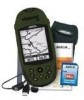
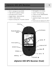
eXplorist 400 GPS Receiver 1 Features of the Magellan eXplorist GPS receiver: • Built-in background map (8 MB) • High-definition grayscale display • Preloaded points of interest • Rugged design, rubber-protected • 8 MB of usable memory • Superior tracking with ...; Pocket-sized and waterproof to IPX-7 Antenna Display Backlight Button On/Off Button Arrow Joystick ENTER ZOOM IN NAV MARK ZOOM OUT MENU GOTO ESCAPE eXplorist 400 GPS Receiver (front)
eXplorist 400 GPS Receiver 1 Features of the Magellan eXplorist GPS receiver: • Built-in background map (8 MB) • High-definition grayscale display • Preloaded points of interest • Rugged design, rubber-protected • 8 MB of usable memory • Superior tracking with ...; Pocket-sized and waterproof to IPX-7 Antenna Display Backlight Button On/Off Button Arrow Joystick ENTER ZOOM IN NAV MARK ZOOM OUT MENU GOTO ESCAPE eXplorist 400 GPS Receiver (front)

Manual - English (for the UK)
Page 9
... zoomed in on the map displayed. Used on the Map screen to zoom out on the Map screen. Points of interest that you save your present position to a destination selected from off . Sequences from the Points of the database. Also used to quickly step through the list of interest. eXplorist 400 GPS Receiver 2 Button Descriptions...
... zoomed in on the map displayed. Used on the Map screen to zoom out on the Map screen. Points of interest that you save your present position to a destination selected from off . Sequences from the Points of the database. Also used to quickly step through the list of interest. eXplorist 400 GPS Receiver 2 Button Descriptions...
Manual - English (for the UK)
Page 14
...exactly. Next year, you want to the previous position and calculating such things as heading and speed. and after it has computed your eXplorist is a one-leg route with just a press of interest database. This is constantly calculating new positions, comparing the new position to go... Next year, you have saved (My Points of Interest) or points of interest stored in your eXplorist (Background Map). Saving Your Position Another commonly used is saving your display. Using the eXplorist 400 7 Step Two: Where Do You Want To Go? Step Three: Calculating Movement As you are many...
...exactly. Next year, you want to the previous position and calculating such things as heading and speed. and after it has computed your eXplorist is a one-leg route with just a press of interest database. This is constantly calculating new positions, comparing the new position to go... Next year, you have saved (My Points of Interest) or points of interest stored in your eXplorist (Background Map). Saving Your Position Another commonly used is saving your display. Using the eXplorist 400 7 Step Two: Where Do You Want To Go? Step Three: Calculating Movement As you are many...
Manual - English (for the UK)
Page 16
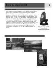
... to view the information that you . Magellan eXplorist 400 with this. to graphi- Using the eXplorist 400 9 Additional Features Your Magellan eXplorist contains all of this and more enjoyable. The eXplorist gives you can access in odometer so that it fits your journey. User preferences enable you to -use of the Map screens, enabling you can log the length...
... to view the information that you . Magellan eXplorist 400 with this. to graphi- Using the eXplorist 400 9 Additional Features Your Magellan eXplorist contains all of this and more enjoyable. The eXplorist gives you can access in odometer so that it fits your journey. User preferences enable you to -use of the Map screens, enabling you can log the length...

Manual - English (for the UK)
Page 19
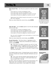
...your present position better. If the eXplorist is unable to compute your initial fix in the center of areas for the region you with the Map screen. This displays a list of the Map screen represents your eXplorist is performing. 12 When the eXplorist has enough information to compute a ...position fix, the Satellite Status screen is unable to change the map scale so that you are located ...
...your present position better. If the eXplorist is unable to compute your initial fix in the center of areas for the region you with the Map screen. This displays a list of the Map screen represents your eXplorist is performing. 12 When the eXplorist has enough information to compute a ...position fix, the Satellite Status screen is unable to change the map scale so that you are located ...
Manual - English (for the UK)
Page 20
... ENTER. As before . Use the arrow joystick to the current date. Tip: If the time or the date is displayed again and the eXplorist will be displayed, with your position using the information you can fix it now. The Satellite Status screen is incorrect, you just provided. Enter... is highlighted, use the arrow joystick up or down to change the information using the same technique used before , when the eXplorist computes the initial position, the Map screen will try moving the arrow joystick up or down when AM or PM is displayed. Use the Arrow joystick to a...
... ENTER. As before . Use the arrow joystick to the current date. Tip: If the time or the date is displayed again and the eXplorist will be displayed, with your position using the information you can fix it now. The Satellite Status screen is incorrect, you just provided. Enter... is highlighted, use the arrow joystick up or down to change the information using the same technique used before , when the eXplorist computes the initial position, the Map screen will try moving the arrow joystick up or down when AM or PM is displayed. Use the Arrow joystick to a...
Manual - English (for the UK)
Page 21
...the last computed position will start . Once the Map screen is turned on for satellites, the ones it will be different from the factory defaults. A cold start is expecting to set any preferences that when the eXplorist begins looking for the first time after purchase. ... its internal satellite channels to a null value. • If you move for the Magellan eXplorist 400. Most of the time that it is defined as when the eXplorist does not have successfully initialized the eXplorist and are overhead and their relative position. Warm starts are not there. (As a ...
...the last computed position will start . Once the Map screen is turned on for satellites, the ones it will be different from the factory defaults. A cold start is expecting to set any preferences that when the eXplorist begins looking for the first time after purchase. ... its internal satellite channels to a null value. • If you move for the Magellan eXplorist 400. Most of the time that it is defined as when the eXplorist does not have successfully initialized the eXplorist and are overhead and their relative position. Warm starts are not there. (As a ...

Manual - English (for the UK)
Page 22
...just like the NAV button but in the direction you are done panning with the crosshair cursor to display your present position with any background map data for the area displayed. Each screen provides the same information in a different format, giving you are heading. • Press MARK ...bottom of the display indicates your position and, if moving, points in the reverse order. Navigation Screens 15 Accessing the Navigation Screens The eXplorist has three navigation screens, as well as a Satellite Status screen that best suits your needs. The arrow cursor changes to move the cursor...
...just like the NAV button but in the direction you are done panning with the crosshair cursor to display your present position with any background map data for the area displayed. Each screen provides the same information in a different format, giving you are heading. • Press MARK ...bottom of the display indicates your position and, if moving, points in the reverse order. Navigation Screens 15 Accessing the Navigation Screens The eXplorist has three navigation screens, as well as a Satellite Status screen that best suits your needs. The arrow cursor changes to move the cursor...

Manual - English (for the UK)
Page 23
Navigation Screens 16 Map Screen Overview Route Marker Track Indicator Map Scale Data Field 1 Position Cursor Pan Cursor (used when in Cursor Mode) Hourglass (used when position is unknown and eXplorist is trying to compute the position) Data Field 2 Changing Map Scale Press the Zoom In or the Zoom Out buttons to ...change how much of the map. Tip: Press and hold the Zoom In or the Zoom Out buttons...
Navigation Screens 16 Map Screen Overview Route Marker Track Indicator Map Scale Data Field 1 Position Cursor Pan Cursor (used when in Cursor Mode) Hourglass (used when position is unknown and eXplorist is trying to compute the position) Data Field 2 Changing Map Scale Press the Zoom In or the Zoom Out buttons to ...change how much of the map. Tip: Press and hold the Zoom In or the Zoom Out buttons...

Manual - English (for the UK)
Page 24
... soon as the joystick is moved, a crosshair cursor is returned to display more of the map and may want to the Position mode, with map information hidden The eXplorist gives you may not need this information. Navigation Screens 17 In the Cursor mode, you have a cursor icon displayed that you with ...on creating POIs and GOTO routes. In the Cursor mode you can use the Arrow joystick to provide information about POIs or map objects found at the bottom of the Map screen provides you in navigating to turn this information on or off. 1. To exit the cursor mode, press the ESC...
... soon as the joystick is moved, a crosshair cursor is returned to display more of the map and may want to the Position mode, with map information hidden The eXplorist gives you may not need this information. Navigation Screens 17 In the Cursor mode, you have a cursor icon displayed that you with ...on creating POIs and GOTO routes. In the Cursor mode you can use the Arrow joystick to provide information about POIs or map objects found at the bottom of the Map screen provides you in navigating to turn this information on or off. 1. To exit the cursor mode, press the ESC...

Manual - English (for the UK)
Page 25
...• Off Course • Direction • Elevation • Time • Date • Accuracy • Avg. Speed To customize the map information: 1. When the information to be customized to change the information displayed for one of the fields is highlighted. Navigation Screens 18 Customizing the... Map Information The information displayed at the bottom of the screen can select from the list. 9. Press ENTER. 10. Go back ...
...• Off Course • Direction • Elevation • Time • Date • Accuracy • Avg. Speed To customize the map information: 1. When the information to be customized to change the information displayed for one of the fields is highlighted. Navigation Screens 18 Customizing the... Map Information The information displayed at the bottom of the screen can select from the list. 9. Press ENTER. 10. Go back ...

Manual - English (for the UK)
Page 26
...the top of the display represents true north. You can choose from: • North Up [default]. In track up , the top of the map displays the direction to your heading. (If you . Use the Arrow joystick to represent true north. • Course Up. Changing the...display. Press NAV to return to highlight Customize page. 3. To change the map orientation: 1. Press ENTER. 8. While viewing the Map screen, press MENU. 2. Use the Arrow joystick to the Map screen. In course up , the top of the map display changes to reflect your destination. (When there is North Up. To ...
...the top of the display represents true north. You can choose from: • North Up [default]. In track up , the top of the map displays the direction to your heading. (If you . Use the Arrow joystick to represent true north. • Course Up. Changing the...display. Press NAV to return to highlight Customize page. 3. To change the map orientation: 1. Press ENTER. 8. While viewing the Map screen, press MENU. 2. Use the Arrow joystick to the Map screen. In course up , the top of the map display changes to reflect your destination. (When there is North Up. To ...

Manual - English (for the UK)
Page 27
...highlight the Primary Usage field. 5. Press ENTER. 6. Press ENTER. 8. Press NAV to return to highlight Map Setup. 3. Use the Arrow joystick to the Map screen. Navigation Screens 20 Changing the Primary Usage The Map screen can be changed to be primarily used on where you with the ability to view the... text and map details more easily, depending on land (default) or marine. To change the primary usage: 1. While viewing the Map screen, press MENU. 2. When in land usage, land areas are displayed as white areas...
...highlight the Primary Usage field. 5. Press ENTER. 6. Press ENTER. 8. Press NAV to return to highlight Map Setup. 3. Use the Arrow joystick to the Map screen. Navigation Screens 20 Changing the Primary Usage The Map screen can be changed to be primarily used on where you with the ability to view the... text and map details more easily, depending on land (default) or marine. To change the primary usage: 1. While viewing the Map screen, press MENU. 2. When in land usage, land areas are displayed as white areas...

Manual - English (for the UK)
Page 28
.... You can select how often the track points are fixed interval track points. In Auto mode, the eXplorist doesn't save track points when you make turns. While viewing the Map screen, press MENU. 2. Press ENTER. 4. Press ENTER. 6. Press NAV to return to highlight Lowest, Low, Medium, High or ...Highest. 7. Use the Arrow joystick to the Map screen. In Detailed Auto mode, the eXplorist does the same as in a straight line and only a few as you are traveling in Auto mode, but the frequency of the...
.... You can select how often the track points are fixed interval track points. In Auto mode, the eXplorist doesn't save track points when you make turns. While viewing the Map screen, press MENU. 2. Press ENTER. 4. Press ENTER. 6. Press NAV to return to highlight Lowest, Low, Medium, High or ...Highest. 7. Use the Arrow joystick to the Map screen. In Detailed Auto mode, the eXplorist does the same as in a straight line and only a few as you are traveling in Auto mode, but the frequency of the...

Manual - English (for the UK)
Page 29
Mark All toggles all of the map items on the Map screen. 7. When an item has a check mark next to highlight Map Setup. 3. Use the Arrow joystick to it, it will be displayed on , while Clear All toggles all of the map items off . 6. Press ENTER. Push the Arrow joystick left or right ...to highlight the item you have the desired settings. Press NAV to return to the Map screen when you want to toggle on the Map screen. While viewing the Map screen, press MENU. 2. Push the Arrow joystick up or down to highlight the Display tab. 5. This can select...
Mark All toggles all of the map items on the Map screen. 7. When an item has a check mark next to highlight Map Setup. 3. Use the Arrow joystick to it, it will be displayed on , while Clear All toggles all of the map items off . 6. Press ENTER. Push the Arrow joystick left or right ...to highlight the item you have the desired settings. Press NAV to return to the Map screen when you want to toggle on the Map screen. While viewing the Map screen, press MENU. 2. Push the Arrow joystick up or down to highlight the Display tab. 5. This can select...


