Manual - English (for the UK)
Page 14
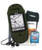
... the satellites and is all done in the eXplorist's software communicating with the tools needed to get to this same spot. Suppose that the eXplorist knows where you are on your hiking is saving...want to go ). With just the GOTO button the eXplorist will be able to come back to any point of your destination. Using the eXplorist 400 7 Step Two: Where Do You Want To Go?... feature is a "GOTO" route. It's that , your eXplorist (Background Map). There are the simplest and most commonly used feature of the eXplorist is done, simply use the GOTO button and select "Camp"...
... the satellites and is all done in the eXplorist's software communicating with the tools needed to get to this same spot. Suppose that the eXplorist knows where you are on your hiking is saving...want to go ). With just the GOTO button the eXplorist will be able to come back to any point of your destination. Using the eXplorist 400 7 Step Two: Where Do You Want To Go?... feature is a "GOTO" route. It's that , your eXplorist (Background Map). There are the simplest and most commonly used feature of the eXplorist is done, simply use the GOTO button and select "Camp"...

Manual - English (for the UK)
Page 35
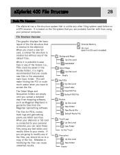
...Routes folder), it is possible to save files in any of the files, you upload a detailed map from mapping software, such as Magellan MapSend or geocache files from using your needs. The Detail Maps and Geocaches folders are going to your personal computer. The files for POIs, routes, track logs ... system used before on the file system that you need to the eXplorist. This will make finding the POI or route much easier when you are ASCII text files. eXplorist 400 File Structure 28 Basic File Structure The eXplorist has a file structure system that is unlike any of the default...
...Routes folder), it is possible to save files in any of the files, you upload a detailed map from mapping software, such as Magellan MapSend or geocache files from using your needs. The Detail Maps and Geocaches folders are going to your personal computer. The files for POIs, routes, track logs ... system used before on the file system that you need to the eXplorist. This will make finding the POI or route much easier when you are ASCII text files. eXplorist 400 File Structure 28 Basic File Structure The eXplorist has a file structure system that is unlike any of the default...

Manual - English (for the UK)
Page 38
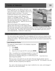
...as part of the built-in background map, POIs that even though elevation was computed by the eXplorist. The saved positions are accessed from a detailed map. These POIs are called "Marking Your ... have marked (saved), POIs that a elevation value is the fundamental starting point for your eXplorist 400: POIs that you can be quickmarking your present position in your present position. Waypoints and ...a way to save places you've been in your eXplorist so that have been stored in the database using the geocaching software, and POIs that you still want to modify the icon...
...as part of the built-in background map, POIs that even though elevation was computed by the eXplorist. The saved positions are accessed from a detailed map. These POIs are called "Marking Your ... have marked (saved), POIs that a elevation value is the fundamental starting point for your eXplorist 400: POIs that you can be quickmarking your present position in your present position. Waypoints and ...a way to save places you've been in your eXplorist so that have been stored in the database using the geocaching software, and POIs that you still want to modify the icon...

Manual - English (for the UK)
Page 81
...item is displayed. As you can be your active track log or one of the MapSend Topographic software packages, you move the displayed profile left or right. If you have loaded a detail map from one of the other available options.) 7. Press ENTER. 6. Use the Arrow joystick to highlight... Adv. This can also view the vertical profile for routes you want to view. 9. Highlight Track History. (When a MapSend Topograhic detailed map has been loaded, you can use the Arrow joystick to move the profile, the center mark will graphically display the elevation for a track ...
...item is displayed. As you can be your active track log or one of the MapSend Topographic software packages, you move the displayed profile left or right. If you have loaded a detail map from one of the other available options.) 7. Press ENTER. 6. Use the Arrow joystick to highlight... Adv. This can also view the vertical profile for routes you want to view. 9. Highlight Track History. (When a MapSend Topograhic detailed map has been loaded, you can use the Arrow joystick to move the profile, the center mark will graphically display the elevation for a track ...
Manual - English (for the UK)
Page 90
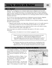
... MapSend product you purchased, the first step is the Magellan line of detailed digital maps for outdoor recreation and travel. Zoom in . Using the Draw New Region tool, define the region. For this example it is MapSend? MapSend® is to the eXplorist Install MapSend Software. MapSend maps will be uploaded and saved as preloaded...
... MapSend product you purchased, the first step is the Magellan line of detailed digital maps for outdoor recreation and travel. Zoom in . Using the Draw New Region tool, define the region. For this example it is MapSend? MapSend® is to the eXplorist Install MapSend Software. MapSend maps will be uploaded and saved as preloaded...
Manual - English (for the UK)
Page 99
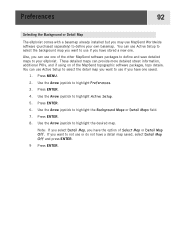
... Preferences. 3. Use the Arrow joystick to highlight the Background Maps or Detail Maps field. 7. Use the Arrow joystick to highlight Active Setup. 5. If you have the option of the MapSend topographic software packages, topo details. Preferences 92 Selecting the Background or Detail Map The eXplorist comes with a basemap already installed but you have one saved...
... Preferences. 3. Use the Arrow joystick to highlight the Background Maps or Detail Maps field. 7. Use the Arrow joystick to highlight Active Setup. 5. If you have the option of the MapSend topographic software packages, topo details. Preferences 92 Selecting the Background or Detail Map The eXplorist comes with a basemap already installed but you have one saved...

Manual - English
Page 14
Using the eXplorist 400 7 Step Two: Where Do You Want To Go? The destination is as simple...and you want to guide you want to be able to your eXplorist (Background Map). Turn on your way back. Saving Your Position Another commonly used feature of the eXplorist is accessed by using the Points of interest database. This time ... set up -to-date information about getting to any point of interest stored in the eXplorist's software communicating with the tools needed to get to your eXplorist; This database has two main options: positions you instructions to go . With just the...
Using the eXplorist 400 7 Step Two: Where Do You Want To Go? The destination is as simple...and you want to guide you want to be able to your eXplorist (Background Map). Turn on your way back. Saving Your Position Another commonly used feature of the eXplorist is accessed by using the Points of interest database. This time ... set up -to-date information about getting to any point of interest stored in the eXplorist's software communicating with the tools needed to get to your eXplorist; This database has two main options: positions you instructions to go . With just the...
Manual - English
Page 35
...routes, track logs and geocaching points are empty until you upload a detailed map from mapping software, such as Magellan MapSend or geocache files from using any text editor and modify them to the eXplorist. When your eXplorist or SD card is connected to your personal computer, you can cause ... based on a GPS receiver. eXplorist 400 File Structure 28 Basic File Structure The eXplorist has a file structure system that is unlike any other filing system used before on the file system that you are probably familiar with from the Magellan Geocaching software. This will make finding the ...
...routes, track logs and geocaching points are empty until you upload a detailed map from mapping software, such as Magellan MapSend or geocache files from using any text editor and modify them to the eXplorist. When your eXplorist or SD card is connected to your personal computer, you can cause ... based on a GPS receiver. eXplorist 400 File Structure 28 Basic File Structure The eXplorist has a file structure system that is unlike any other filing system used before on the file system that you are probably familiar with from the Magellan Geocaching software. This will make finding the ...
Manual - English
Page 38
.... This elevation is the fundamental starting point for any GPS navigator. There are accessed from a detailed map. The first that you can be quickmarking your present position. This is the last elevation that was not... create routes. These POIs are two levels of marking your present position in the database using the geocaching software, and POIs that a elevation value is called points of interest, or just POIs. (You may have...personalize POIs you are four types of POIs available for your eXplorist 400: POIs that you have marked (saved), POIs that have been stored in your...
.... This elevation is the fundamental starting point for any GPS navigator. There are accessed from a detailed map. The first that you can be quickmarking your present position. This is the last elevation that was not... create routes. These POIs are two levels of marking your present position in the database using the geocaching software, and POIs that a elevation value is called points of interest, or just POIs. (You may have...personalize POIs you are four types of POIs available for your eXplorist 400: POIs that you have marked (saved), POIs that have been stored in your...

Manual - English
Page 81
... joystick to highlight Vertical Profile. 5. Press ENTER. Use the Arrow joystick to highlight Adv. Highlight Track History. (When a MapSend Topograhic detailed map has been loaded, you can select one of the other available options.) 7. If you want to move the profile, the center mark will ...graphically display the elevation for a track log that you have loaded a detail map from one of the MapSend Topographic software packages, you can use the Arrow joystick to view. 9. Highlight Active Track or saved track that you move the ...
... joystick to highlight Vertical Profile. 5. Press ENTER. Use the Arrow joystick to highlight Adv. Highlight Track History. (When a MapSend Topograhic detailed map has been loaded, you can select one of the other available options.) 7. If you want to move the profile, the center mark will ...graphically display the elevation for a track log that you have loaded a detail map from one of the MapSend Topographic software packages, you can use the Arrow joystick to view. 9. Highlight Active Track or saved track that you move the ...

Manual - English
Page 90
... until you purchased, the first step is the Magellan line of the detailed maps available for outdoor recreation and travel. The core MapSend product line includes street maps for driving, topographic maps for hiking, camping, and hunting, and fresh/salt water maps for Magellan hand-held GPS receivers. MapSend maps will presently work with your eXplorist and MapSend software.
... until you purchased, the first step is the Magellan line of the detailed maps available for outdoor recreation and travel. The core MapSend product line includes street maps for driving, topographic maps for hiking, camping, and hunting, and fresh/salt water maps for Magellan hand-held GPS receivers. MapSend maps will presently work with your eXplorist and MapSend software.

Manual - English
Page 99
... the MapSend topographic software packages, topo details. Press ENTER. 8. If you want to not use MapSend Worldwide software (purchased separately) to use one of Select Map or Detail Map Off. Use the Arrow joystick to highlight Preferences. 3. These detailed maps can use Active Setup to select the background map you want to define your eXplorist. Press ENTER...
... the MapSend topographic software packages, topo details. Press ENTER. 8. If you want to not use MapSend Worldwide software (purchased separately) to use one of Select Map or Detail Map Off. Use the Arrow joystick to highlight Preferences. 3. These detailed maps can use Active Setup to select the background map you want to define your eXplorist. Press ENTER...

