
Triton User Manual Addendum - English, French, Spanish
Page 1
... the screen. To access area calculation, press ENTER while viewing the Map screen. When you move, the Triton will be presented with the option of assigning a name to the Triton, press ENTER again and select "Stop & Save Track". Triton User Manual Addendum This addendum applies to Triton GPS receivers that have a software version that you want to it's current location, point B. On the contextual menu, select "Start New Track". Pressing ENTER on any navigational screen press ENTER. Pause and Resume Active Track.
... the screen. To access area calculation, press ENTER while viewing the Map screen. When you move, the Triton will be presented with the option of assigning a name to the Triton, press ENTER again and select "Stop & Save Track". Triton User Manual Addendum This addendum applies to Triton GPS receivers that have a software version that you want to it's current location, point B. On the contextual menu, select "Start New Track". Pressing ENTER on any navigational screen press ENTER. Pause and Resume Active Track.

Triton User Manual Addendum - English, French, Spanish
Page 2
... the next destination (D). You can now select which point in a Multileg Route. Set Custom Position provides a way to view map areas other then your mind, you change your present position. To turn the feature off and resume computing GPS position information, go to bring up the contextual menu. When the route is set a user-defined map datum for your active route. Provide the information for the datum. Select "Set Custom Position" from the contextual menu. Select View > Settings > Navigation. To set a User Map Datum, press MENU from any navigational screen.
... the next destination (D). You can now select which point in a Multileg Route. Set Custom Position provides a way to view map areas other then your mind, you change your present position. To turn the feature off and resume computing GPS position information, go to bring up the contextual menu. When the route is set a user-defined map datum for your active route. Provide the information for the datum. Select "Set Custom Position" from the contextual menu. Select View > Settings > Navigation. To set a User Map Datum, press MENU from any navigational screen.
Manual - English
Page 5
...4 Turning the Triton off 4 Setting the display backlight intensity 4 Setting the Time Zone 4 Changing Languages 5 Sleep Mode (Backlight Timer 5 Waking up the Triton from Sleep Mode 5 Setting the Backlight Timer 5 Automatic Power Off 6 Setting the Power Off Timer interval 6 Menus ...6 Accessing the Main Menu 6 Navigation Screens 7 Accessing the Map Screen Contextual Menu 7 Accessing the Speedometer Contextual Menu 7 Data Fields ...8 Customizing the Data Field for the Map Screen 8 Customizing the Data Field for the Large Data, Compass or Satellite Status Screen .. 8 Selecting Maps...
...4 Turning the Triton off 4 Setting the display backlight intensity 4 Setting the Time Zone 4 Changing Languages 5 Sleep Mode (Backlight Timer 5 Waking up the Triton from Sleep Mode 5 Setting the Backlight Timer 5 Automatic Power Off 6 Setting the Power Off Timer interval 6 Menus ...6 Accessing the Main Menu 6 Navigation Screens 7 Accessing the Map Screen Contextual Menu 7 Accessing the Speedometer Contextual Menu 7 Data Fields ...8 Customizing the Data Field for the Map Screen 8 Customizing the Data Field for the Large Data, Compass or Satellite Status Screen .. 8 Selecting Maps...
Manual - English
Page 6
... and Set Times 21 Creating a Go To Route from the Map Screen 22 Viewing Waypoint Details from the Map Screen 22 Creating a Backtrack Route 23 Changing Map Options 23 Changing Map Units of Measure 24 Changing Map Units of Measure 25 Using the Keyboard ...26 Date Entry ...29 Text Size Limitations 29 Page Selection ...29 Profiles ...30 Activating a Profile 30 Editing a Profile 30 Information Page (assigns which navigation screens are displayed 30 Display Page 30 Map Page ...30 Sensors Page (Magellan Triton 500 31 Alarms Page ...31 Waypoints ...32 Waypoint Detail Screen Overview...
... and Set Times 21 Creating a Go To Route from the Map Screen 22 Viewing Waypoint Details from the Map Screen 22 Creating a Backtrack Route 23 Changing Map Options 23 Changing Map Units of Measure 24 Changing Map Units of Measure 25 Using the Keyboard ...26 Date Entry ...29 Text Size Limitations 29 Page Selection ...29 Profiles ...30 Activating a Profile 30 Editing a Profile 30 Information Page (assigns which navigation screens are displayed 30 Display Page 30 Map Page ...30 Sensors Page (Magellan Triton 500 31 Alarms Page ...31 Waypoints ...32 Waypoint Detail Screen Overview...
Manual - English
Page 7
... the Map Screen 34 Creating a Custom Waypoint Using the Triton Menu 35 Viewing Waypoints 35 Viewing a Saved Waypoint 35 Editing Waypoints 36 Editing a Saved Waypoint 36 Deleting a Saved Waypoint 36 Deleting a Saved Waypoint (Alternate Method 36 Deleting All Saved Waypoints 37 Duplicating a Saved Waypoint 37 Settings ...38 Customizing Navigation Settings 38 Setting Volume and Brightness 38 View Memory Usage 38 Clearing Memory 39 Restoring Factory Settings 39 Setting Connectivity 39 Getting Software Version Information 40 Viewing Copyright Information 40 Personalizing Magellan...
... the Map Screen 34 Creating a Custom Waypoint Using the Triton Menu 35 Viewing Waypoints 35 Viewing a Saved Waypoint 35 Editing Waypoints 36 Editing a Saved Waypoint 36 Deleting a Saved Waypoint 36 Deleting a Saved Waypoint (Alternate Method 36 Deleting All Saved Waypoints 37 Duplicating a Saved Waypoint 37 Settings ...38 Customizing Navigation Settings 38 Setting Volume and Brightness 38 View Memory Usage 38 Clearing Memory 39 Restoring Factory Settings 39 Setting Connectivity 39 Getting Software Version Information 40 Viewing Copyright Information 40 Personalizing Magellan...
Manual - English
Page 13
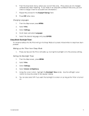
... battery life the Triton will need to the desired interval. 6. Waking up , turning the backlight on . Use the left/right cursor control to move the slider to change it here for the Daylight Savings field. 8. Setting the Backlight Timer 1. Select Settings. 4. Select View. 3. Using the cursor control, highlight the Backlight Timer slider. From the drop-down and select Language. 5. From the Map screen press MENU. 2. Select the desired language and press ENTER. Repeat the process for accurate time information.) 7. Select Settings. 4. Select View...
... battery life the Triton will need to the desired interval. 6. Waking up , turning the backlight on . Use the left/right cursor control to move the slider to change it here for the Daylight Savings field. 8. Setting the Backlight Timer 1. Select Settings. 4. Select View. 3. Using the cursor control, highlight the Backlight Timer slider. From the drop-down and select Language. 5. From the Map screen press MENU. 2. Select the desired language and press ENTER. Repeat the process for accurate time information.) 7. Select Settings. 4. Select View...

Manual - English
Page 14
... and select Power Options. 5. Select Power Off Timer. 6. Menus Accessing the features of the Magellan Triton is used to turn off the Triton. Waypoint, Place, Trail, Geocache, Route, and Trips. The Route option displays routes that you would like to follow from your Magellan Triton. Accessing the Main Menu 1. The Create Menu has the same options as part of these are used to select a destination waypoint that the Triton will be available in a future update. From the Map screen, press MENU. 2. The Trips...
... and select Power Options. 5. Select Power Off Timer. 6. Menus Accessing the features of the Magellan Triton is used to turn off the Triton. Waypoint, Place, Trail, Geocache, Route, and Trips. The Route option displays routes that you would like to follow from your Magellan Triton. Accessing the Main Menu 1. The Create Menu has the same options as part of these are used to select a destination waypoint that the Triton will be available in a future update. From the Map screen, press MENU. 2. The Trips...

Manual - English
Page 15
... button. (There are creating audio clips and playing MP3 music files. (Magellan Triton 400 & 500 only). The Geocache option allows you can use or geocaching. Use Settings to access navigation settings, adjust volume and brightness, select connectivity, view memory details, as well as a route that are associated with multiple legs. Accessing the Map Screen Contextual Menu 1. Press ESC to close the menu. The Media option contains the functions for information on updates to add new geocache locations from your current track (a record of waypoints...
... button. (There are creating audio clips and playing MP3 music files. (Magellan Triton 400 & 500 only). The Geocache option allows you can use or geocaching. Use Settings to access navigation settings, adjust volume and brightness, select connectivity, view memory details, as well as a route that are associated with multiple legs. Accessing the Map Screen Contextual Menu 1. Press ESC to close the menu. The Media option contains the functions for information on updates to add new geocache locations from your current track (a record of waypoints...
Manual - English
Page 20
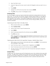
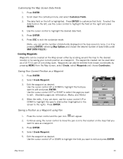
...needed during normal use the cursor control to select the Navigation screen you return to operations associated with them. Customizing the Data Fields for the Large Data, Compass or Satellite Status Screen 1. Select ENTER. 5. While viewing a screen that would be displayed in pale orange. 2. Select the Profile to the end of the route, current time, date, destination, XTE, elevation, current speed, average speed, maximum speed, distance made good (DMG), estimated time of data fields under MAP DATA FIELDS.) Customizing the Data Field for the Map Screen 1. You can select from the...
...needed during normal use the cursor control to select the Navigation screen you return to operations associated with them. Customizing the Data Fields for the Large Data, Compass or Satellite Status Screen 1. Select ENTER. 5. While viewing a screen that would be displayed in pale orange. 2. Select the Profile to the end of the route, current time, date, destination, XTE, elevation, current speed, average speed, maximum speed, distance made good (DMG), estimated time of data fields under MAP DATA FIELDS.) Customizing the Data Field for the Map Screen 1. You can select from the...
Manual - English
Page 21
... covered by the detailed map, the map information from the detailed map will be displayed.) Waypoints (user-created or preloaded in the Map Screen chapter. 1. Note that the contextual menu for resetting the odometer. (Additionally, the odometer can be reset from the Map screen by their icons on the screen. Accessing the Map Screen Contextual Menu The functions of day and satellite signal strength. The header bar shows battery level, time of the various menu options will be discussed...
... covered by the detailed map, the map information from the detailed map will be displayed.) Waypoints (user-created or preloaded in the Map Screen chapter. 1. Note that the contextual menu for resetting the odometer. (Additionally, the odometer can be reset from the Map screen by their icons on the screen. Accessing the Map Screen Contextual Menu The functions of day and satellite signal strength. The header bar shows battery level, time of the various menu options will be discussed...
Manual - English
Page 23
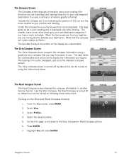
... Map screen, press MENU. 2. Press ENTER. 7. The smaller, black arrow is the bearing to your next destination waypoint if you require. Turning on the standard compass screen. Like the Strip Compass, the Road Compass is your position and heading. Select View. 3. Navigation Screens 15 Highlight Yes and press ENTER. The Road Compass Screen The Road Compass screen displays the compass information in a familiar graphical format. Select Profiles. 4. The large green arrow is turned off by default but can be turned...
... Map screen, press MENU. 2. Press ENTER. 7. The smaller, black arrow is the bearing to your next destination waypoint if you require. Turning on the standard compass screen. Like the Strip Compass, the Road Compass is your position and heading. Select View. 3. Navigation Screens 15 Highlight Yes and press ENTER. The Road Compass Screen The Road Compass screen displays the compass information in a familiar graphical format. Select Profiles. 4. The large green arrow is turned off by default but can be turned...

Manual - English
Page 27
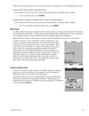
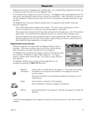
... the screen. User can access the commonly used screen in the direction of Day GPS Signal Strength North Indicator Data Fields Map Scale Pan Mode Map Legend Present Position Cursor (Points in the Magellan Triton and it has a special contextual menu that can assign a different icon from this screen an important part of getting the most commonly used functions. Map Screen Overview Battery Level Time of travel .) Trail (Track that can be performed directly from the Waypoint Information screen.) Map Screen 19 Default icon shown. Map Screen The Map screen...
... the screen. User can access the commonly used screen in the direction of Day GPS Signal Strength North Indicator Data Fields Map Scale Pan Mode Map Legend Present Position Cursor (Points in the Magellan Triton and it has a special contextual menu that can assign a different icon from this screen an important part of getting the most commonly used functions. Map Screen Overview Battery Level Time of travel .) Trail (Track that can be performed directly from the Waypoint Information screen.) Map Screen 19 Default icon shown. Map Screen The Map screen...
Manual - English
Page 28
... select Customize Fields. 3. The data field on the right and press ENTER. 4. Use the cursor control to customize that you want to none, 2 or 4 by pressing ENTER, selecting Map Options and choose the desired number of a multileg route. Waypoints can be entered from the Map screen, select Create, select Waypoints and choose Coordinates. Select Create Waypoint. 3. Edit the waypoint as desired. When the edits, if any, are Information, Media, and Alerts.) 4. Press ENTER. Press the cursor control and the pan icon...
... select Customize Fields. 3. The data field on the right and press ENTER. 4. Use the cursor control to customize that you want to none, 2 or 4 by pressing ENTER, selecting Map Options and choose the desired number of a multileg route. Waypoints can be entered from the Map screen, select Create, select Waypoints and choose Coordinates. Select Create Waypoint. 3. Edit the waypoint as desired. When the edits, if any, are Information, Media, and Alerts.) 4. Press ENTER. Press the cursor control and the pan icon...
Manual - English
Page 32
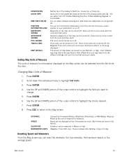
... ENTER. 2. Waypoints on the map can be turned on the Map screen can be selected from Off, Distance/Bearing Direction, Distance/Bearing Degrees, or Coordinates. Quick Info is the header bar shown at the top of measure for information displayed on or off , the Magellan Triton will continue to Low, Medium, or High. DISTANCE SPEED ELEVATION BAROMETER UNITS Choose from your needs. Resetting Speed and Odometers From the Map screen you may have to highlight Set Units. 3. You can select from...
... ENTER. 2. Waypoints on the map can be turned on the Map screen can be selected from Off, Distance/Bearing Direction, Distance/Bearing Degrees, or Coordinates. Quick Info is the header bar shown at the top of measure for information displayed on or off , the Magellan Triton will continue to Low, Medium, or High. DISTANCE SPEED ELEVATION BAROMETER UNITS Choose from your needs. Resetting Speed and Odometers From the Map screen you may have to highlight Set Units. 3. You can select from...
Manual - English
Page 40
... the direction and distance to the waypoint from your current location. Waypoint Information Media Used to get the most out of waypoints and their use addresses to enter or modify data for the waypoint. An understanding of your destination. User-Created, Place and Geocache waypoints. User-created waypoints are the key to your Magellan Triton. More information on geocache waypoints can be found in the Triton's internal memory. This screen provides a way to get from your home to navigating and creating routes...
... the direction and distance to the waypoint from your current location. Waypoint Information Media Used to get the most out of waypoints and their use addresses to enter or modify data for the waypoint. An understanding of your destination. User-Created, Place and Geocache waypoints. User-created waypoints are the key to your Magellan Triton. More information on geocache waypoints can be found in the Triton's internal memory. This screen provides a way to get from your home to navigating and creating routes...
Manual - English
Page 41
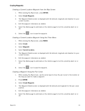
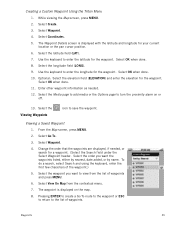
... Media page to add media or the Options page to save the waypoint. Press ENTER. 3. Creating Waypoints Creating a Current Location Waypoint from the Map Screen 1. Select Create. 3. The Waypoint Details screen is displayed with the latitude, longitude and elevation for your current location. 6. While viewing the Map screen, press ENTER. 2. Edit the waypoint information as needed . 7. Creating a Current Location Waypoint Using the Triton Menu 1. Select Waypoint. 4. Creating a Waypoint Using the Pan Cursor 1. Waypoints 33 Select the icon to turn the proximity alarm on or...
... Media page to add media or the Options page to save the waypoint. Press ENTER. 3. Creating Waypoints Creating a Current Location Waypoint from the Map Screen 1. Select Create. 3. The Waypoint Details screen is displayed with the latitude, longitude and elevation for your current location. 6. While viewing the Map screen, press ENTER. 2. Edit the waypoint information as needed . 7. Creating a Current Location Waypoint Using the Triton Menu 1. Select Waypoint. 4. Creating a Waypoint Using the Pan Cursor 1. Waypoints 33 Select the icon to turn the proximity alarm on or...
Manual - English
Page 42
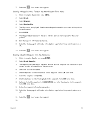
... elevation for the waypoint. Select OK when done. 9. Select the Media page to add media or the Options page to enter the longitude for the waypoint. Waypoints 34 7. Creating a Waypoint from the Map Screen 1. Select Waypoint. 4. Select Point on the Map Using the Triton Menu 1. Use the arrow keypad to move the pan cursor to save the waypoint. Edit the waypoint information as needed . 9. Select the icon to save the waypoint.. Creating a Custom Waypoint from a Point on Map. 5. The Waypoint Details screen is displayed. Select the longitude field (LONG...
... elevation for the waypoint. Select OK when done. 9. Select the Media page to add media or the Options page to enter the longitude for the waypoint. Waypoints 34 7. Creating a Waypoint from the Map Screen 1. Select Waypoint. 4. Select Point on the Map Using the Triton Menu 1. Use the arrow keypad to move the pan cursor to save the waypoint. Edit the waypoint information as needed . 9. Select the icon to save the waypoint.. Creating a Custom Waypoint from a Point on Map. 5. The Waypoint Details screen is displayed. Select the longitude field (LONG...
Manual - English
Page 43
...: Select the elevation field (ELEVATION) and enter the elevation for a waypoint. (Select the Search field under the Select Waypoint header. Select Waypoint. 4. Change the order that the waypoints are displayed, if needed . 12. Select View On Map from the list of waypoints and press MENU. 6. Select the longitude field (LONG). 9. Select OK when done. 10. Select the Media page to add media or the Options page to enter the latitude for your current location or the pan cursor position. 6. Select the Viewing Waypoints icon to enter...
...: Select the elevation field (ELEVATION) and enter the elevation for a waypoint. (Select the Search field under the Select Waypoint header. Select Waypoint. 4. Change the order that the waypoints are displayed, if needed . 12. Select View On Map from the list of waypoints and press MENU. 6. Select the longitude field (LONG). 9. Select OK when done. 10. Select the Media page to add media or the Options page to enter the latitude for your current location or the pan cursor position. 6. Select the Viewing Waypoints icon to enter...

Manual - English
Page 50
Geocache Waypoints Geocaching is displayed. From the Map screen, press MENU. 2. If you are marking a new cache location you can use the keyboard to add media (image) from the internet, adding it into their Magellan Triton. Press PAGE / GO TO to input a geocache waypoint that someone else has established that can turn the proximity alarm on geocaching for the cache. Editing a Saved Geocache Waypoint 1. Creating a Geocache Waypoint You may want to create a new geocache waypoint for others to find or you...
Geocache Waypoints Geocaching is displayed. From the Map screen, press MENU. 2. If you are marking a new cache location you can use the keyboard to add media (image) from the internet, adding it into their Magellan Triton. Press PAGE / GO TO to input a geocache waypoint that someone else has established that can turn the proximity alarm on geocaching for the cache. Editing a Saved Geocache Waypoint 1. Creating a Geocache Waypoint You may want to create a new geocache waypoint for others to find or you...
Manual - English
Page 55
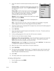
... the route leg destinations: Select the destination waypoint and choose the delete (trash can) icon to Add Point. Confirm the deletion. (This does not remove the waypoint from the Triton's memory, only from the list of Place waypoints and press ENTER. 5. From the Map screen press MENU. 2. Waypoint: Select a waypoint from the route.) Viewing the route: Select the View icon in the route. The Route Create screen is displayed, make necessary changes. Select the green checkmark to be used. Select the method for determining the starting waypoint...
... the route leg destinations: Select the destination waypoint and choose the delete (trash can) icon to Add Point. Confirm the deletion. (This does not remove the waypoint from the Triton's memory, only from the list of Place waypoints and press ENTER. 5. From the Map screen press MENU. 2. Waypoint: Select a waypoint from the route.) Viewing the route: Select the View icon in the route. The Route Create screen is displayed, make necessary changes. Select the green checkmark to be used. Select the method for determining the starting waypoint...


