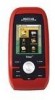
Manual - English
Page 7
... Getting Software Version Information 40 Viewing Copyright Information 40 Personalizing Magellan Triton 40 Performing Diagnostic Checks 40 Geocache Waypoints ...42 Creating a Geocache Waypoint 42 Editing a Saved Geocache Waypoint 42 Deleting a Saved Geocache Waypoint 43 Deleting a Saved Geocache Waypoint (Alternate Method 43 Deleting All Saved Geocache Waypoints 44 Duplicating a Saved Geocache Waypoint 44 Routes ...45 Go To Routes ...45 Creating...
... Getting Software Version Information 40 Viewing Copyright Information 40 Personalizing Magellan Triton 40 Performing Diagnostic Checks 40 Geocache Waypoints ...42 Creating a Geocache Waypoint 42 Editing a Saved Geocache Waypoint 42 Deleting a Saved Geocache Waypoint 43 Deleting a Saved Geocache Waypoint (Alternate Method 43 Deleting All Saved Geocache Waypoints 44 Duplicating a Saved Geocache Waypoint 44 Routes ...45 Go To Routes ...45 Creating...

Manual - English
Page 14
... is a saved track.) The Geocache option allows you to select a saved geocache waypoint and use it as the Go To Menu but these menu options brings up the menu for information on an optional SD card (400 & 500) or into the Magellan Triton. Selecting one of these are used... to select a destination waypoint that has been either preloaded into the Magellan Triton as part of the Magellan Triton is used to create waypoints and multileg routes that you forget to turn off the Triton. Waypoint, Place, Trail, Geocache, ...
... is a saved track.) The Geocache option allows you to select a saved geocache waypoint and use it as the Go To Menu but these menu options brings up the menu for information on an optional SD card (400 & 500) or into the Magellan Triton. Selecting one of these are used... to select a destination waypoint that has been either preloaded into the Magellan Triton as part of the Magellan Triton is used to create waypoints and multileg routes that you forget to turn off the Triton. Waypoint, Place, Trail, Geocache, ...

Manual - English
Page 15
...geocache. For Speedometer you to a series of waypoints that could have options menus that are two additional screens, Strip Compass and Road Compass, that can be added from earlier trips, or waypoints that are creating audio clips and playing MP3 music files. (Magellan Triton 400...installed), that can be discussed in detail in the Magellan Triton. The Profiles option is not available. While viewing the Speedometer screen, press MENU. The Geocache option allows you can use or geocaching. Fundamentals 7 hiking, marine use again to your present position, by ...
...geocache. For Speedometer you to a series of waypoints that could have options menus that are two additional screens, Strip Compass and Road Compass, that can be added from earlier trips, or waypoints that are creating audio clips and playing MP3 music files. (Magellan Triton 400...installed), that can be discussed in detail in the Magellan Triton. The Profiles option is not available. While viewing the Speedometer screen, press MENU. The Geocache option allows you can use or geocaching. Fundamentals 7 hiking, marine use again to your present position, by ...
Manual - English
Page 32
You can be turned off, show only the icons or show both the icons and their name. Geocache waypoints on the map can be turned on or off . Use the UP and DOWN portion of the cursor control to highlight the choice desired. 7. ... your current position to Low, Medium, or High. Track lines can be measured in Meters or Feet. (Magellan Triton 500 only) Choose between showing four data fields, two data fields or turning them off , the Magellan Triton will continue to North Up, Course Up, or Track Up. Setting Map Units of Measure The units...
You can be turned off, show only the icons or show both the icons and their name. Geocache waypoints on the map can be turned on or off . Use the UP and DOWN portion of the cursor control to highlight the choice desired. 7. ... your current position to Low, Medium, or High. Track lines can be measured in Meters or Feet. (Magellan Triton 500 only) Choose between showing four data fields, two data fields or turning them off , the Magellan Triton will continue to North Up, Course Up, or Track Up. Setting Map Units of Measure The units...
Manual - English
Page 37
...Geocache Information screens, have tabs across the top of the display is another method to the day portion of the calendar. Information page, Media page and Alerts page. Using the Keyboard 29 There is no option for inputting the current date for the Magellan Triton...GO TO button, but the cursor control will need to select them from the GPS satellite. Date Entry The Magellan Triton uses a standard calendar display to select different pages for the function. With ...the month selector arrows is automatically received from ; If one of the calendar is highlighted you will work as well.
...Geocache Information screens, have tabs across the top of the display is another method to the day portion of the calendar. Information page, Media page and Alerts page. Using the Keyboard 29 There is no option for inputting the current date for the Magellan Triton...GO TO button, but the cursor control will need to select them from the GPS satellite. Date Entry The Magellan Triton uses a standard calendar display to select different pages for the function. With ...the month selector arrows is automatically received from ; If one of the calendar is highlighted you will work as well.
Manual - English
Page 38
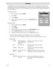
...Meters, NtMi/Feet Kph, Mph, Kts Meters, Feet kPa, Millibar, inHg, mmHg Sets the unit of measure for speed measurements. Profiles The Magellan Triton gives you can customize the profiles to fit your track. Each profile contains custom settings that the background colors for barometric measurements. Activating a Profile... North, your heading (course) or your particular needs. Profiles 30 Sets the unit of measure for elevation measurements. (Magellan Triton 500 only) Sets the unit of measure for distance measurements. Hiking, Marine and Geocaching. From the Map screen press MENU. 2.
...Meters, NtMi/Feet Kph, Mph, Kts Meters, Feet kPa, Millibar, inHg, mmHg Sets the unit of measure for speed measurements. Profiles The Magellan Triton gives you can customize the profiles to fit your track. Each profile contains custom settings that the background colors for barometric measurements. Activating a Profile... North, your heading (course) or your particular needs. Profiles 30 Sets the unit of measure for elevation measurements. (Magellan Triton 500 only) Sets the unit of measure for distance measurements. Hiking, Marine and Geocaching. From the Map screen press MENU. 2.
Manual - English
Page 39
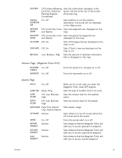
... displayed on will alert you to as you when the Magellan Triton loses GPS signals. Sensors Page (Magellan Triton 500) ELECTRONIC COMPASS BAROMETER On, Off On, Off Turns the electronic compass on or off . Sets the type of detailed information that the Magellan Triton will alert you a geocache waypoint. Sets the volume level for the audible alarm. Sets...
... displayed on will alert you to as you when the Magellan Triton loses GPS signals. Sensors Page (Magellan Triton 500) ELECTRONIC COMPASS BAROMETER On, Off On, Off Turns the electronic compass on or off . Sets the type of detailed information that the Magellan Triton will alert you a geocache waypoint. Sets the volume level for the audible alarm. Sets...
Manual - English
Page 40
... preloaded into the base map or one of where you want to go, the Triton can provide the necessary information to your Magellan Triton. This screen also provides information on geocaching, but you enter a unique name for the waypoint. The Magellan Triton has three different classifications for newly created waypoints. User-created waypoints are and a waypoint...
... preloaded into the base map or one of where you want to go, the Triton can provide the necessary information to your Magellan Triton. This screen also provides information on geocaching, but you enter a unique name for the waypoint. The Magellan Triton has three different classifications for newly created waypoints. User-created waypoints are and a waypoint...

Manual - English
Page 50
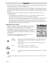
... Terrain (1 though 5 with GPS users. Press PAGE / GO TO to access the Options page where you can use the keyboard to enter the hint and descriptions. 7. Select the the waypoint. Geocache Waypoints Geocaching is displayed. Creating a Geocache Waypoint You may want to ... (image) from Current Location, Point on geocaching for other geocaching sites. They post these geocache waypoints into your Magellan Triton either by creating a geocache waypoint or by saving the geocache file from the internet, adding it into their Magellan Triton. From the Map screen, press MENU. ...
... Terrain (1 though 5 with GPS users. Press PAGE / GO TO to access the Options page where you can use the keyboard to enter the hint and descriptions. 7. Select the the waypoint. Geocache Waypoints Geocaching is displayed. Creating a Geocache Waypoint You may want to ... (image) from Current Location, Point on geocaching for other geocaching sites. They post these geocache waypoints into your Magellan Triton either by creating a geocache waypoint or by saving the geocache file from the internet, adding it into their Magellan Triton. From the Map screen, press MENU. ...
Manual - English
Page 51
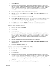
... list of the waypoint.) 5. When the waypoint name is highlighted press MENU. Use the PAGE / GO TO button to select the page to the Geocache Waypoint Details page. 9. Select the green checkmark to save the changes and return to view. From the Map screen, press MENU. 2. From the ...by nearest, date added, or by name. To do a search, select Search and using the keyboard, enter the first few characters of the waypoint.) 5. Geocaching 43 Select the waypoint you want to delete from the list of waypoints. Select the order you want the waypoints listed, either by nearest, date...
... list of the waypoint.) 5. When the waypoint name is highlighted press MENU. Use the PAGE / GO TO button to select the page to the Geocache Waypoint Details page. 9. Select the green checkmark to save the changes and return to view. From the Map screen, press MENU. 2. From the ...by nearest, date added, or by name. To do a search, select Search and using the keyboard, enter the first few characters of the waypoint.) 5. Geocaching 43 Select the waypoint you want to delete from the list of waypoints. Select the order you want the waypoints listed, either by nearest, date...
Manual - English
Page 52
...highlighted use the cursor control to select the info icon to duplicate from the list of waypoints. 5. Select the green checkmark to the Select Geocache page. Select Go To. 3. Confirm the deletion by selecting Yes. To do a search, select Search and using the keyboard, enter the... first few characters of the waypoint by name. Deleting All Saved Geocache Waypoints 1. Select the order you are displayed, if needed, or search for a waypoint. (Select the Search field under the Select Waypoint header....
...highlighted use the cursor control to select the info icon to duplicate from the list of waypoints. 5. Select the green checkmark to the Select Geocache page. Select Go To. 3. Confirm the deletion by selecting Yes. To do a search, select Search and using the keyboard, enter the... first few characters of the waypoint by name. Deleting All Saved Geocache Waypoints 1. Select the order you are displayed, if needed, or search for a waypoint. (Select the Search field under the Select Waypoint header....
Manual - English
Page 54
Creating a Go To Route to a Place Waypoint 1. Select Geocache. 4. If needed, change the order that the waypoints are displayed or search for a waypoint. ((Select the Search field under the Places header to from the ... keyboard and enter the first few characters of waypoints and press ENTER. From the Map screen press MENU. 2. Routes 46 Creating a Go To Route to a Geocache Waypoint 1. From the Map screen press MENU. (Alternate Method: Press and hold the GO TO button while the present position cursor is displayed on a waypoint...
Creating a Go To Route to a Place Waypoint 1. Select Geocache. 4. If needed, change the order that the waypoints are displayed or search for a waypoint. ((Select the Search field under the Places header to from the ... keyboard and enter the first few characters of waypoints and press ENTER. From the Map screen press MENU. 2. Routes 46 Creating a Go To Route to a Geocache Waypoint 1. From the Map screen press MENU. (Alternate Method: Press and hold the GO TO button while the present position cursor is displayed on a waypoint...
Manual - English
Page 55
...if required). Select Save Route. 12. Select the green checkmark when done. 13. From the Map screen press MENU. 2. Geocache: Select a waypoint from the list of saved geocache waypoints and press ENTER. The Route Create screen is on Map: Use the arrow keys to use this waypoint. When the...the pan cursor is displayed with a graphical representation of the route. 10. Confirm the deletion. (This does not remove the waypoint from the Triton's memory, only from the list of the route leg destinations: Select the destination waypoint and choose the delete (trash can) icon to the right...
...if required). Select Save Route. 12. Select the green checkmark when done. 13. From the Map screen press MENU. 2. Geocache: Select a waypoint from the list of saved geocache waypoints and press ENTER. The Route Create screen is on Map: Use the arrow keys to use this waypoint. When the...the pan cursor is displayed with a graphical representation of the route. 10. Confirm the deletion. (This does not remove the waypoint from the Triton's memory, only from the list of the route leg destinations: Select the destination waypoint and choose the delete (trash can) icon to the right...
