
Triton User Manual Addendum - English, French, Spanish
Page 1
....0138 The Main Menu and Contextual Menu Access. From any navigational screen. Select "Pause Track Record". User Grid. (Advanced Users) You can set a user grid as the Coordinate System for the perimeter and area. To access area calculation, press ENTER while viewing the Map screen. As you move, the Triton will record your track, following your Triton. When you want to pause the recording of your current track (or a saved track or route) and computes the...
....0138 The Main Menu and Contextual Menu Access. From any navigational screen. Select "Pause Track Record". User Grid. (Advanced Users) You can set a user grid as the Coordinate System for the perimeter and area. To access area calculation, press ENTER while viewing the Map screen. As you move, the Triton will record your track, following your Triton. When you want to pause the recording of your current track (or a saved track or route) and computes the...

Triton User Manual Addendum - English, French, Spanish
Page 2
... navigational screen. Select View > Settings > Navigation. On the COORDINATE SYSTEM drop-down menu, select User. Provide the information for the datum. The Navigation screen will be displayed with options to the location you activate a route with User set as the coordinate system. When selecting a user datum, you can tell the Triton to go to the next destination (C) and repeat the process to go to bring up the contextual menu. Select View > Settings > Navigation. On the MAP DATUM drop-down menu, select User Grid. Set Custom Position. When setting a custom position...
... navigational screen. Select View > Settings > Navigation. On the COORDINATE SYSTEM drop-down menu, select User. Provide the information for the datum. The Navigation screen will be displayed with options to the location you activate a route with User set as the coordinate system. When selecting a user datum, you can tell the Triton to go to the next destination (C) and repeat the process to go to bring up the contextual menu. Select View > Settings > Navigation. On the MAP DATUM drop-down menu, select User Grid. Set Custom Position. When setting a custom position...
Manual - English
Page 2
... for navigating. USE CARE The Global Positioning System (GPS) is dangerous and can also be injured. Taking your selected destination. i USE PROPER ACCESSORIES Use only Magellan cables and antennas; Never rely solely on the Magellan Triton while driving. Please do not try and change in accordance with the Department of position fixes can result in arriving at your eyes off the road is operated...
... for navigating. USE CARE The Global Positioning System (GPS) is dangerous and can also be injured. Taking your selected destination. i USE PROPER ACCESSORIES Use only Magellan cables and antennas; Never rely solely on the Magellan Triton while driving. Please do not try and change in accordance with the Department of position fixes can result in arriving at your eyes off the road is operated...
Manual - English
Page 5
...4 Turning the Triton off 4 Setting the display backlight intensity 4 Setting the Time Zone 4 Changing Languages 5 Sleep Mode (Backlight Timer 5 Waking up the Triton from Sleep Mode 5 Setting the Backlight Timer 5 Automatic Power Off 6 Setting the Power Off Timer interval 6 Menus ...6 Accessing the Main Menu 6 Navigation Screens 7 Accessing the Map Screen Contextual Menu 7 Accessing the Speedometer Contextual Menu 7 Data Fields ...8 Customizing the Data Field for the Map Screen 8 Customizing the Data Field for the Large Data, Compass or Satellite Status Screen .. 8 Selecting Maps...
...4 Turning the Triton off 4 Setting the display backlight intensity 4 Setting the Time Zone 4 Changing Languages 5 Sleep Mode (Backlight Timer 5 Waking up the Triton from Sleep Mode 5 Setting the Backlight Timer 5 Automatic Power Off 6 Setting the Power Off Timer interval 6 Menus ...6 Accessing the Main Menu 6 Navigation Screens 7 Accessing the Map Screen Contextual Menu 7 Accessing the Speedometer Contextual Menu 7 Data Fields ...8 Customizing the Data Field for the Map Screen 8 Customizing the Data Field for the Large Data, Compass or Satellite Status Screen .. 8 Selecting Maps...
Manual - English
Page 6
... Map Screen Data Fields 20 Saving Your Current Position as a Waypoint 20 Saving a Position as a Waypoint using Pan 20 Displaying Best Fishing and Hunting Times 21 Displaying Solar and Lunar Rise and Set Times 21 Creating a Go To Route from the Map Screen 22 Viewing Waypoint Details from the Map Screen 22 Creating a Backtrack Route 23 Changing Map Options 23 Changing Map Units of Measure 24 Changing Map Units of Measure 25 Using the Keyboard ...26 Date Entry ...29 Text Size Limitations 29 Page Selection ...29 Profiles ...30 Activating a Profile 30 Editing a Profile 30 Information...
... Map Screen Data Fields 20 Saving Your Current Position as a Waypoint 20 Saving a Position as a Waypoint using Pan 20 Displaying Best Fishing and Hunting Times 21 Displaying Solar and Lunar Rise and Set Times 21 Creating a Go To Route from the Map Screen 22 Viewing Waypoint Details from the Map Screen 22 Creating a Backtrack Route 23 Changing Map Options 23 Changing Map Units of Measure 24 Changing Map Units of Measure 25 Using the Keyboard ...26 Date Entry ...29 Text Size Limitations 29 Page Selection ...29 Profiles ...30 Activating a Profile 30 Editing a Profile 30 Information...
Manual - English
Page 7
... the Map Screen 34 Creating a Custom Waypoint Using the Triton Menu 35 Viewing Waypoints 35 Viewing a Saved Waypoint 35 Editing Waypoints 36 Editing a Saved Waypoint 36 Deleting a Saved Waypoint 36 Deleting a Saved Waypoint (Alternate Method 36 Deleting All Saved Waypoints 37 Duplicating a Saved Waypoint 37 Settings ...38 Customizing Navigation Settings 38 Setting Volume and Brightness 38 View Memory Usage 38 Clearing Memory 39 Restoring Factory Settings 39 Setting Connectivity 39 Getting Software Version Information 40 Viewing Copyright Information 40 Personalizing Magellan...
... the Map Screen 34 Creating a Custom Waypoint Using the Triton Menu 35 Viewing Waypoints 35 Viewing a Saved Waypoint 35 Editing Waypoints 36 Editing a Saved Waypoint 36 Deleting a Saved Waypoint 36 Deleting a Saved Waypoint (Alternate Method 36 Deleting All Saved Waypoints 37 Duplicating a Saved Waypoint 37 Settings ...38 Customizing Navigation Settings 38 Setting Volume and Brightness 38 View Memory Usage 38 Clearing Memory 39 Restoring Factory Settings 39 Setting Connectivity 39 Getting Software Version Information 40 Viewing Copyright Information 40 Personalizing Magellan...
Manual - English
Page 13
... Daylight Savings field. 8. Press any key and the Triton will go into Sleep Mode at a preset interval when no keys have been pressed. Select View. 3. 6. Changing Languages 1. Using the cursor control, highlight the Backlight Timer slider. Sleep Mode (Backlight Timer) To conserve battery life the Triton will wake up the Triton from Sleep Mode 1. From the Map screen, press MENU. 2. Fundamentals 5 Select Volume & Brightness. 5. If you travel to an area with a different time zone, you want the backlight...
... Daylight Savings field. 8. Press any key and the Triton will go into Sleep Mode at a preset interval when no keys have been pressed. Select View. 3. 6. Changing Languages 1. Using the cursor control, highlight the Backlight Timer slider. Sleep Mode (Backlight Timer) To conserve battery life the Triton will wake up the Triton from Sleep Mode 1. From the Map screen, press MENU. 2. Fundamentals 5 Select Volume & Brightness. 5. If you travel to an area with a different time zone, you want the backlight...

Manual - English
Page 14
... interval that the Triton will be saved by entering the coordinates for information on updates to your present location, by selecting a point on an optional SD card (400 & 500) or into the Magellan Triton. From the Map screen, press MENU. 2. Select Power Off Timer. 6. Accessing the Main Menu 1. The Trips option will turn off the Triton. Check the Magellan website at www.magellangps.com for a known waypoint. Fundamentals 6 Select View. 3. Select Settings. 4. Menus Accessing the features of these are used to select a destination waypoint...
... interval that the Triton will be saved by entering the coordinates for information on updates to your present location, by selecting a point on an optional SD card (400 & 500) or into the Magellan Triton. From the Map screen, press MENU. 2. Select Power Off Timer. 6. Accessing the Main Menu 1. The Trips option will turn off the Triton. Check the Magellan website at www.magellangps.com for a known waypoint. Fundamentals 6 Select View. 3. Select Settings. 4. Menus Accessing the features of these are used to select a destination waypoint...

Manual - English
Page 15
... the Magellan Triton from earlier trips, or waypoints that can use or geocaching. The View Menu has options for information on the map or by pressing the PAGE / GO TO or ESC button. (There are creating audio clips and playing MP3 music files. (Magellan Triton 400 & 500 only). hiking, marine use again to close the contextual menu. The Maps option displays a list of this manual. Navigation Screen options menus The Map and Speedometer screens have been created and saved...
... the Magellan Triton from earlier trips, or waypoints that can use or geocaching. The View Menu has options for information on the map or by pressing the PAGE / GO TO or ESC button. (There are creating audio clips and playing MP3 music files. (Magellan Triton 400 & 500 only). hiking, marine use again to close the contextual menu. The Maps option displays a list of this manual. Navigation Screen options menus The Map and Speedometer screens have been created and saved...
Manual - English
Page 20
..., bearing, distance to next waypoint, distance to the end of the route, time to next waypoint, time to display data that is the most of arrival (ETA), accuracy, velocity made good (VMG), odometer, and current trip odometer. While viewing the Map screen, select ENTER. 2. Select the field you . Contextual Menus The Map screen, the Compass screen and the Speedometer screen, have the data fields customized to the end of the route, current time, date, destination, XTE, elevation, current speed, average speed, maximum speed, distance made good (DMG), estimated time of the operations...
..., bearing, distance to next waypoint, distance to the end of the route, time to next waypoint, time to display data that is the most of arrival (ETA), accuracy, velocity made good (VMG), odometer, and current trip odometer. While viewing the Map screen, select ENTER. 2. Select the field you . Contextual Menus The Map screen, the Compass screen and the Speedometer screen, have the data fields customized to the end of the route, current time, date, destination, XTE, elevation, current speed, average speed, maximum speed, distance made good (DMG), estimated time of the operations...
Manual - English
Page 21
... the detailed map, the map information from the detailed map will be displayed by their icons on the Magellan Triton 500. If the track has been saved, it is an active route being used. A pink line is user customizable). Current Location Screen The Current Location screen contains information about your present position at the arrow cursor along with white dots. From the Compass or Speedometer screen, press MENU. Also, if you have a route activated, it...
... the detailed map, the map information from the detailed map will be displayed by their icons on the Magellan Triton 500. If the track has been saved, it is an active route being used. A pink line is user customizable). Current Location Screen The Current Location screen contains information about your present position at the arrow cursor along with white dots. From the Compass or Speedometer screen, press MENU. Also, if you have a route activated, it...
Manual - English
Page 23
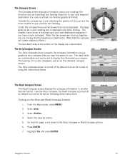
... Strip Compass, the Road Compass is turned off by default but can be turned on using a graphical strip compass that can be set to use. Turning on the standard compass screen. Highlight Yes and press ENTER. Select View. 3. Press ENTER. 7. Navigation Screens 15 The data fields are travelling) and bearing (direction to your next waypoint destination if a route is your position and heading. The Road Compass Screen The Road Compass screen displays the compass information in a familiar graphical format. From the Map screen, press MENU. 2. On...
... Strip Compass, the Road Compass is turned off by default but can be turned on using a graphical strip compass that can be set to use. Turning on the standard compass screen. Highlight Yes and press ENTER. Select View. 3. Press ENTER. 7. Navigation Screens 15 The data fields are travelling) and bearing (direction to your next waypoint destination if a route is your position and heading. The Road Compass Screen The Road Compass screen displays the compass information in a familiar graphical format. From the Map screen, press MENU. 2. On...

Manual - English
Page 27
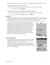
... route originated.) Current Route Indicator (Line displaying line of sight to the destination from the Waypoint Information screen.) Map Screen 19 This makes understanding the Map screen and all of getting the most commonly used screen in the receiver. Red dot points towards your receiver. Default icon shown. User can access the commonly used functions. Map Screen Overview Battery Level Time of Day GPS Signal Strength North Indicator Data Fields Map Scale Pan Mode Map Legend Present Position Cursor (Points in the direction of travel .) Trail (Track...
... route originated.) Current Route Indicator (Line displaying line of sight to the destination from the Waypoint Information screen.) Map Screen 19 This makes understanding the Map screen and all of getting the most commonly used screen in the receiver. Red dot points towards your receiver. Default icon shown. User can access the commonly used functions. Map Screen Overview Battery Level Time of Day GPS Signal Strength North Indicator Data Fields Map Scale Pan Mode Map Legend Present Position Cursor (Points in the direction of travel .) Trail (Track...
Manual - English
Page 28
... can set the number of data fields displayed on the map screen to edit and press ENTER. Press the cursor control and the pan icon will appear. 2. Use the cursor control UP or DOWN to highlight the field you want to the right). Use the cursor control to the desired location or by pressing MENU from known coordinates by saving your current position as a GO TO or part of data fields under MAP DATA FIELDS.) Creating Waypoints Waypoints...
... can set the number of data fields displayed on the map screen to edit and press ENTER. Press the cursor control and the pan icon will appear. 2. Use the cursor control UP or DOWN to highlight the field you want to the right). Use the cursor control to the desired location or by pressing MENU from known coordinates by saving your current position as a GO TO or part of data fields under MAP DATA FIELDS.) Creating Waypoints Waypoints...
Manual - English
Page 40
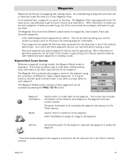
User-Created, Place and Geocache waypoints. User-created waypoints are the key to navigating and creating routes. This can be done by saving your Magellan Triton. More information on geocache waypoints can use addresses to get you are waypoints that are used for each waypoint. It is for accepting the waypoint and saving it to your current location. This screen also provides information on the map or by pressing the PAGE / GO TO button. The green checkmark is a good practice...
User-Created, Place and Geocache waypoints. User-created waypoints are the key to navigating and creating routes. This can be done by saving your Magellan Triton. More information on geocache waypoints can use addresses to get you are waypoints that are used for each waypoint. It is for accepting the waypoint and saving it to your current location. This screen also provides information on the map or by pressing the PAGE / GO TO button. The green checkmark is a good practice...
Manual - English
Page 41
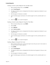
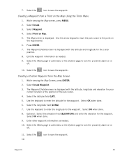
...the Media page to add media or the Options page to turn the proximity alarm on the map you want to turn the proximity alarm on or off. 8. Creating a Waypoint Using the Pan Cursor 1. Press ENTER. 3. Select Create Waypoint. 4. Edit the waypoint information as needed. 5. Creating Waypoints Creating a Current Location Waypoint from the Map Screen 1. Select the icon to save the waypoint. Select Create. 3. Creating a Current Location Waypoint Using the Triton Menu 1. Select the icon to save the waypoint. While viewing the Map screen, use the arrow keys to move the...
...the Media page to add media or the Options page to turn the proximity alarm on the map you want to turn the proximity alarm on or off. 8. Creating a Waypoint Using the Pan Cursor 1. Press ENTER. 3. Select Create Waypoint. 4. Edit the waypoint information as needed. 5. Creating Waypoints Creating a Current Location Waypoint from the Map Screen 1. Select the icon to save the waypoint. Select Create. 3. Creating a Current Location Waypoint Using the Triton Menu 1. Select the icon to save the waypoint. While viewing the Map screen, use the arrow keys to move the...
Manual - English
Page 42
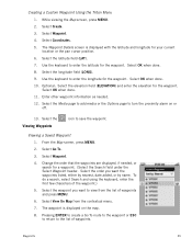
... elevation field (ELEVATION) and enter the elevation for the waypoint. Enter other waypoint information as needed . 10. Select the Media page to add media or the Options page to turn the proximity alarm on the map desired. 6. Select Point on the Map Using the Triton Menu 1. Select OK when done. 8. 7. The Waypoint Details screen is displayed with the latitude and longitude for the waypoint. Select the icon to enter the latitude for the cursor position. 8. Select Create. 3. Use the keyboard to save the waypoint...
... elevation field (ELEVATION) and enter the elevation for the waypoint. Enter other waypoint information as needed . 10. Select the Media page to add media or the Options page to turn the proximity alarm on the map desired. 6. Select Point on the Map Using the Triton Menu 1. Select OK when done. 8. 7. The Waypoint Details screen is displayed with the latitude and longitude for the waypoint. Select the icon to enter the latitude for the cursor position. 8. Select Create. 3. Use the keyboard to save the waypoint...
Manual - English
Page 43
... for a waypoint. (Select the Search field under the Select Waypoint header. Select Waypoint. 4. Select View On Map from the list of the waypoint.) 5. Change the order that the waypoints are displayed, if needed . 12. While viewing the Map screen, press MENU. 2. Optional: Select the elevation field (ELEVATION) and enter the elevation for your current location or the pan cursor position. 6. Select the Media page to add media or the Options page to enter the latitude for the waypoint. Viewing a Saved Waypoint 1. Select the Viewing Waypoints icon to the...
... for a waypoint. (Select the Search field under the Select Waypoint header. Select Waypoint. 4. Select View On Map from the list of the waypoint.) 5. Change the order that the waypoints are displayed, if needed . 12. While viewing the Map screen, press MENU. 2. Optional: Select the elevation field (ELEVATION) and enter the elevation for your current location or the pan cursor position. 6. Select the Media page to add media or the Options page to enter the latitude for the waypoint. Viewing a Saved Waypoint 1. Select the Viewing Waypoints icon to the...

Manual - English
Page 50
...their Magellan Triton. Select Create. 3. icon to add media (image) from the SD card installed in finding the cache. Geocache Waypoints Geocaching is displayed. They post these geocache waypoints into your Magellan Triton either by creating a geocache waypoint or by saving the geocache file from Current Location, Point on Map or Coordinates. (If you are entering waypoint information manually, you can turn the proximity alarm on geocaching for the cache. Select Geocache. 4. On this page you would probably select current location. From the Map screen, press MENU...
...their Magellan Triton. Select Create. 3. icon to add media (image) from the SD card installed in finding the cache. Geocache Waypoints Geocaching is displayed. They post these geocache waypoints into your Magellan Triton either by creating a geocache waypoint or by saving the geocache file from Current Location, Point on Map or Coordinates. (If you are entering waypoint information manually, you can turn the proximity alarm on geocaching for the cache. Select Geocache. 4. On this page you would probably select current location. From the Map screen, press MENU...
Manual - English
Page 55
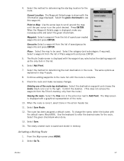
... the Triton's memory, only from the list of the route leg destinations: Select the destination waypoint and choose the delete (trash can) icon to Add Point. Place: Select the map to use this waypoint. Activating a Multileg Route 1. Select Add Point. 7. Select a waypoint from the route.) Viewing the route: Select the View icon in the list. 6. Select Go To. When the Waypoint Details page is complete. 9. Select Save Route. 12. Current Location: The Waypoint Details page is displayed with the Information page displayed. Press ENTER. The Route Create screen is...
... the Triton's memory, only from the list of the route leg destinations: Select the destination waypoint and choose the delete (trash can) icon to Add Point. Place: Select the map to use this waypoint. Activating a Multileg Route 1. Select Add Point. 7. Select a waypoint from the route.) Viewing the route: Select the View icon in the list. 6. Select Go To. When the Waypoint Details page is complete. 9. Select Save Route. 12. Current Location: The Waypoint Details page is displayed with the Information page displayed. Press ENTER. The Route Create screen is...


