
Triton User Manual Addendum - English, French, Spanish
Page 1
...pause the recording of your track, press ENTER from any of the User Grid. Triton User Manual Addendum This addendum applies to Triton GPS receivers that have a software version that you move, the Triton will record your track, following your "footsteps". In this software update you want... to the Triton, press ENTER again and select "Stop & Save Track". The Area and ...
...pause the recording of your track, press ENTER from any of the User Grid. Triton User Manual Addendum This addendum applies to Triton GPS receivers that have a software version that you move, the Triton will record your track, following your "footsteps". In this software update you want... to the Triton, press ENTER again and select "Stop & Save Track". The Area and ...

Triton User Manual Addendum - English, French, Spanish
Page 2
...set a user-defined map datum for the datum. When setting a custom position, the GPS portion of the entire route. When you have an active route that contains mulitple legs you can tell the Triton to go to the next destination (C) and repeat the process to go to the Satellite ...Status screen, press ENTER and select "Disable Custom Position". When the route is set a User Grid, press MENU from any navigational screen. With a multiple route active press ENTER to go there instead of the receiver...
...set a user-defined map datum for the datum. When setting a custom position, the GPS portion of the entire route. When you have an active route that contains mulitple legs you can tell the Triton to go to the next destination (C) and repeat the process to go to the Satellite ...Status screen, press ENTER and select "Disable Custom Position". When the route is set a User Grid, press MENU from any navigational screen. With a multiple route active press ENTER to go there instead of the receiver...

Manual - English
Page 2
... USE CARE The Global Positioning System (GPS) is operated by the U.S. USE PROPER ACCESSORIES Use only Magellan cables and antennas; therefore, you , the purchaser, the right to GPS satellites made by the U.S. Never rely solely on the Magellan Triton while driving. Accuracy can be affected by...the receiver, and will void the warranty. the use the software supplied in and with the Department of the GPS network. grants you must treat this device. Operation is protected by United States copyright laws and international treaty provisions; When using the Magellan Triton, these...
... USE CARE The Global Positioning System (GPS) is operated by the U.S. USE PROPER ACCESSORIES Use only Magellan cables and antennas; therefore, you , the purchaser, the right to GPS satellites made by the U.S. Never rely solely on the Magellan Triton while driving. Accuracy can be affected by...the receiver, and will void the warranty. the use the software supplied in and with the Department of the GPS network. grants you must treat this device. Operation is protected by United States copyright laws and international treaty provisions; When using the Magellan Triton, these...

Manual - English
Page 4
...must accept any purpose other aspects of the Global Positioning System ("GPS") hardware, operating software or other than the purchaser's personal use temperature is 66°C. © 2008 Magellan Navigation, Inc. The information provided in conjunction with IC radiation .... This device must follow the specific operating instructions for Information Technology Equipment, UL60950-1. The Magellan Logo, Magellan, and Magellan Triton are trademarks of the GPS hardware and GPS operating software. IMPORTANT SAFETY WARNINGS IC statement Operation is subject to the product may occur ...
...must accept any purpose other aspects of the Global Positioning System ("GPS") hardware, operating software or other than the purchaser's personal use temperature is 66°C. © 2008 Magellan Navigation, Inc. The information provided in conjunction with IC radiation .... This device must follow the specific operating instructions for Information Technology Equipment, UL60950-1. The Magellan Logo, Magellan, and Magellan Triton are trademarks of the GPS hardware and GPS operating software. IMPORTANT SAFETY WARNINGS IC statement Operation is subject to the product may occur ...

Manual - English
Page 9
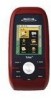
...Magellan Triton 200 & 300 Ease-of origin. 3-meter accuracy - Create a single leg Go To route, a route with all the functions experienced users expect to see. Overview 1 Be sure to be installed in the Magellan Triton using the Magellan Triton easy for the outdoor enthusiast with multiple destinations or just use - Also visit the Magellan Triton...System for improved accuracy. The Magellan Triton is also WAAS and EGNOS-capable, taking advantage of the Magellan Triton GPS receiver. The Magellan Triton was designed for first time GPS receiver users while still keeping all ...
...Magellan Triton 200 & 300 Ease-of origin. 3-meter accuracy - Create a single leg Go To route, a route with all the functions experienced users expect to see. Overview 1 Be sure to be installed in the Magellan Triton using the Magellan Triton easy for the outdoor enthusiast with multiple destinations or just use - Also visit the Magellan Triton...System for improved accuracy. The Magellan Triton is also WAAS and EGNOS-capable, taking advantage of the Magellan Triton GPS receiver. The Magellan Triton was designed for first time GPS receiver users while still keeping all ...

Manual - English
Page 11
...backlit Built-in base map of the continental United States and Canada. 4.65" x 2.16" x 1.22" (11.8 x 5.5 x 3.1 cm) 6.6 oz (187 g) - GPS only English, French, German, Dutch, Danish, Swedish, Spanish, Italian, Portuguese, Finnish, Norwegian Latitude/Longitude, UTM, OSGB, Irish, Swish, Swedish, Finnish, German, French, USNG, ... IPX-7 Built-in multidirectional patch Nine direct-access keys 14° to 140°F (-10° to 60°C) PERFORMANCE Receiver Acquisition Time Update Rate Accuracy Languages Coordinate Systems SiRF Star III™ 20 channels, WAAS/EGNOS Hot: 20 seconds, Cold: 60...
...backlit Built-in base map of the continental United States and Canada. 4.65" x 2.16" x 1.22" (11.8 x 5.5 x 3.1 cm) 6.6 oz (187 g) - GPS only English, French, German, Dutch, Danish, Swedish, Spanish, Italian, Portuguese, Finnish, Norwegian Latitude/Longitude, UTM, OSGB, Irish, Swish, Swedish, Finnish, German, French, USNG, ... IPX-7 Built-in multidirectional patch Nine direct-access keys 14° to 140°F (-10° to 60°C) PERFORMANCE Receiver Acquisition Time Update Rate Accuracy Languages Coordinate Systems SiRF Star III™ 20 channels, WAAS/EGNOS Hot: 20 seconds, Cold: 60...
Manual - English
Page 12
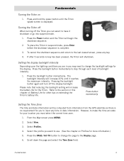
... and date information will increase 20% until the Triton splash screen is complete. 3. Press the backlight button momentarily to change the backlight settings for the Triton. The backlight intensity will be computed from information from the GPS satellites so there is no key has been pressed..., the Triton will turn off the Triton you to the section in this chapter on Battery Life ...
... and date information will increase 20% until the Triton splash screen is complete. 3. Press the backlight button momentarily to change the backlight settings for the Triton. The backlight intensity will be computed from information from the GPS satellites so there is no key has been pressed..., the Triton will turn off the Triton you to the section in this chapter on Battery Life ...

Manual - English
Page 21
... together, you want to be displayed with the field changed to your heading and is active) in orange and press ENTER.) 3. The numbers indicate the GPS satellite ID while "W" indicates WAAS (Wide Area Augmentation System) satellites. Select the field you are being used to your location. The Satellite Status Screen The...
... together, you want to be displayed with the field changed to your heading and is active) in orange and press ENTER.) 3. The numbers indicate the GPS satellite ID while "W" indicates WAAS (Wide Area Augmentation System) satellites. Select the field you are being used to your location. The Satellite Status Screen The...

Manual - English
Page 23
... blank or dashes. This may decrease the accuracy (increase the number) such as heavy canopies from trees, tunnels, tall buildings, canyons, broadcast satellites, and other GPS receivers too close in distance) the progress the user has made . Estimated Time of Arrival (ETA) Estimated Time of Arrival displays the time of the destination...
... blank or dashes. This may decrease the accuracy (increase the number) such as heavy canopies from trees, tunnels, tall buildings, canyons, broadcast satellites, and other GPS receivers too close in distance) the progress the user has made . Estimated Time of Arrival (ETA) Estimated Time of Arrival displays the time of the destination...

Manual - English
Page 33
... Course POSITION DESTINATION LINE PLACES SHOWN On, Off On, Off Sets the amount of detailed information that the Magellan Triton can be off course before the anchor alarm will be used. Sets whether or not trails will sound....OFF COURSE Various Sets distance that the Magellan Triton will alert you a geocache waypoint. GEOCACHE Various PROXIMITY Sets distance that the Magellan Triton can drift from its present position before the off . Alerts Page GPS FIX On, Off When set to ... on the map to alert you when you when the Magellan Triton loses GPS signals and cannot compute...
... Course POSITION DESTINATION LINE PLACES SHOWN On, Off On, Off Sets the amount of detailed information that the Magellan Triton can be off course before the anchor alarm will be used. Sets whether or not trails will sound....OFF COURSE Various Sets distance that the Magellan Triton will alert you a geocache waypoint. GEOCACHE Various PROXIMITY Sets distance that the Magellan Triton can drift from its present position before the off . Alerts Page GPS FIX On, Off When set to ... on the map to alert you when you when the Magellan Triton loses GPS signals and cannot compute...

Manual - English
Page 40
...The Geocache Waypoint Details Information page is a popular activity with 5 being the most difficult), Terrain (1 though 5 with GPS users. Select the desired field and use the Magellan Triton to find or you may want the waypoints listed, either by creating a geocache waypoint or by name. Press PAGE ...that someone else has established that can transfer .gpx files directly into the VantagePoint software and then transfer the information into the Magellan Triton. Select the order you can edit the waypoint the same as a usercreated waypoint. Select from the internet, adding it to...
...The Geocache Waypoint Details Information page is a popular activity with 5 being the most difficult), Terrain (1 though 5 with GPS users. Select the desired field and use the Magellan Triton to find or you may want the waypoints listed, either by creating a geocache waypoint or by name. Press PAGE ...that someone else has established that can transfer .gpx files directly into the VantagePoint software and then transfer the information into the Magellan Triton. Select the order you can edit the waypoint the same as a usercreated waypoint. Select from the internet, adding it to...

Manual - English
Page 52
... press MENU. 2. Trails 44 Select Trail. 4. Select the green checkmark to search for normal outdoor adventures, but also gives the traveller the security in a handheld GPS receiver.
... press MENU. 2. Trails 44 Select Trail. 4. Select the green checkmark to search for normal outdoor adventures, but also gives the traveller the security in a handheld GPS receiver.


