
Triton User Manual Addendum - English, French, Spanish
Page 1
...your current location. Scroll down the contextual menu and select "View Area Calculation". Pause and Resume Active Track. Triton User Manual Addendum This addendum applies to Triton GPS receivers that have a software version that you can now access the Main Menu on any navigational screen press ... On the contextual menu, select "Start New Track". When you want to it's current location, point B. User Grid. (Advanced Users) You can pause and then resume recording your "footsteps". Triton 300 Triton 400 Triton 500 Triton 1500 Triton 2000 01.90.00.0279 01.74.00.0278...
...your current location. Scroll down the contextual menu and select "View Area Calculation". Pause and Resume Active Track. Triton User Manual Addendum This addendum applies to Triton GPS receivers that have a software version that you can now access the Main Menu on any navigational screen press ... On the contextual menu, select "Start New Track". When you want to it's current location, point B. User Grid. (Advanced Users) You can pause and then resume recording your "footsteps". Triton 300 Triton 400 Triton 500 Triton 1500 Triton 2000 01.90.00.0279 01.74.00.0278...
Manual - English
Page 8
... a Trail 51 Deleting a Trail 52 Deleting a Trail (Alternate Method 52 Duplicating a Trail 53 Reversing a Trail 53 Hiding/Showing a Trail 53 Activating a Backtrack Route 54 Clearing Track 54 Places ...55 Go To a Place Waypoint (base map 55 Searching for a Place Waypoint (Detail Map 55 Turning On/Off the Waypoint Proximity Alarm for... Times for a Place Waypoint 56 Viewing Sun and Moon Rise and Set Times for a Place Waypoint 57 Media ...58 Browsing Photographs 58 Table of Contents Magellan Triton 4
... a Trail 51 Deleting a Trail 52 Deleting a Trail (Alternate Method 52 Duplicating a Trail 53 Reversing a Trail 53 Hiding/Showing a Trail 53 Activating a Backtrack Route 54 Clearing Track 54 Places ...55 Go To a Place Waypoint (base map 55 Searching for a Place Waypoint (Detail Map 55 Turning On/Off the Waypoint Proximity Alarm for... Times for a Place Waypoint 56 Viewing Sun and Moon Rise and Set Times for a Place Waypoint 57 Media ...58 Browsing Photographs 58 Table of Contents Magellan Triton 4
Manual - English
Page 9
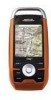
... and tracks - Ability to your outdoor adventures safe and enjoyable. Microphone and speaker enable you explore. Upload your digital music to an optional SD card and enjoy a customized soundtrack as you navigate and attach them to make your point of the Magellan Triton 2.7" color...functions experienced users expect to enjoy clear private listening of the Magellan Triton GPS receiver. Get accurate compass readings while standing still, even without a GPS fix, and no matter how you hold the receiver. (GPS receivers without an electronic compass require that you can be kept ...
... and tracks - Ability to your outdoor adventures safe and enjoyable. Microphone and speaker enable you explore. Upload your digital music to an optional SD card and enjoy a customized soundtrack as you navigate and attach them to make your point of the Magellan Triton 2.7" color...functions experienced users expect to enjoy clear private listening of the Magellan Triton GPS receiver. Get accurate compass readings while standing still, even without a GPS fix, and no matter how you hold the receiver. (GPS receivers without an electronic compass require that you can be kept ...
Manual - English
Page 15
... button to create a waypoint from your Magellan Triton. Go To, Create and View. You can be saved by entering the coordinates for a known waypoint. Use the Waypoint option to turn the flashlight on and off. The Place option is a saved track.) The Geocache option allows you to select... or by the Magellan Triton. This can select from the list. (A Trail is not available. Waypoint, Place, Trail, Geocache, Route, and Trips. The Go To Menu has six options; Menus Accessing the features of the receiver. The Main Menu has three options; Flashlight The Triton has a three ...
... button to create a waypoint from your Magellan Triton. Go To, Create and View. You can be saved by entering the coordinates for a known waypoint. Use the Waypoint option to turn the flashlight on and off. The Place option is a saved track.) The Geocache option allows you to select... or by the Magellan Triton. This can select from the list. (A Trail is not available. Waypoint, Place, Trail, Geocache, Route, and Trips. The Go To Menu has six options; Menus Accessing the features of the receiver. The Main Menu has three options; Flashlight The Triton has a three ...
Manual - English
Page 16
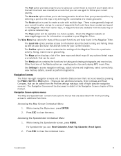
... hiking, marine use again to follow your present position, by selecting a point on updates to your current location. Accessing the Map Screen Contextual Menu 1. For Speedometer you can: Reset Odometer, Reset Trip Odometer, Reset Speed. 2. The Trips option will be available in the Magellan Triton... Screens The Triton has eight navigation screens and a Satellite Status screen that can be accessed by entering the coordinates of a known geocache. The Trail option provides a way for you to save your current track (a record of your travels since the last time track was cleared)...
... hiking, marine use again to follow your present position, by selecting a point on updates to your current location. Accessing the Map Screen Contextual Menu 1. For Speedometer you can: Reset Odometer, Reset Trip Odometer, Reset Speed. 2. The Trips option will be available in the Magellan Triton... Screens The Triton has eight navigation screens and a Satellite Status screen that can be accessed by entering the coordinates of a known geocache. The Trail option provides a way for you to save your current track (a record of your travels since the last time track was cleared)...
Manual - English
Page 22
If the track has been saved, it is displayed in the Map Screen chapter. 1. The Map screen can display up to hide all the data fields. A north indicator ... Line is user customizable). Tap again on the map as a blue dashed line (color is a straight line displaying LOS (line of sight) from your movements (track) is also displayed that rotates to the next destination waypoint. Navigation Screens 14
If the track has been saved, it is displayed in the Map Screen chapter. 1. The Map screen can display up to hide all the data fields. A north indicator ... Line is user customizable). Tap again on the map as a blue dashed line (color is a straight line displaying LOS (line of sight) from your movements (track) is also displayed that rotates to the next destination waypoint. Navigation Screens 14

Manual - English
Page 27
... moves away from the target point. If the user is moving away from trees, tunnels, tall buildings, canyons, broadcast satellites, and other GPS receivers too close in distance) the progress the user has made . Accuracy Accuracy calculates the margin of error the user can expect based on their...how fast the user is closing their satellite reception. Elevation Elevation measures the height above or below Sea Level which is 0. Cross Track Error (XTE) Cross Track Error measures how far the user is off the direct course to a final destination point, the number should match the Current Speed...
... moves away from the target point. If the user is moving away from trees, tunnels, tall buildings, canyons, broadcast satellites, and other GPS receivers too close in distance) the progress the user has made . Accuracy Accuracy calculates the margin of error the user can expect based on their...how fast the user is closing their satellite reception. Elevation Elevation measures the height above or below Sea Level which is 0. Cross Track Error (XTE) Cross Track Error measures how far the user is off the direct course to a final destination point, the number should match the Current Speed...

Manual - English
Page 28
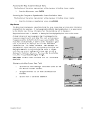
... location.) Track (Displays previous travel.) Trail (Track that can be performed directly from the Waypoint Information screen.) Map Screen 20 Map Screen Overview Battery Level Time of getting the most commonly used functions. User can access the commonly used screen in the Magellan Triton and it... has a special contextual menu that can assign a different icon from this screen an important part of Day GPS Signal Strength North Indicator Data Fields Map Scale Pan Mode Map Legend Present Position Cursor (Points in the receiver. This makes...
... location.) Track (Displays previous travel.) Trail (Track that can be performed directly from the Waypoint Information screen.) Map Screen 20 Map Screen Overview Battery Level Time of getting the most commonly used functions. User can access the commonly used screen in the Magellan Triton and it... has a special contextual menu that can assign a different icon from this screen an important part of Day GPS Signal Strength North Indicator Data Fields Map Scale Pan Mode Map Legend Present Position Cursor (Points in the receiver. This makes...

Manual - English
Page 32
...shown and how it is displayed. Press ENTER. 4. If you will be changed. Creating a Backtrack Route 1. Note: if there are not sufficient track points (breadcrumbs) to create a backtrack route you want to select Cancel Route. 3. Press ENTER. 8. Scroll down the contextual menu to highlight Map... the cursor control to highlight the map option you want to the Map screen. Backtrack Route As you travel, the Magellan Triton drops electronic breadcrumbs (track) to highlight the choice you want for you would create a backtrack route. Use the UP and DOWN portion of...
...shown and how it is displayed. Press ENTER. 4. If you will be changed. Creating a Backtrack Route 1. Note: if there are not sufficient track points (breadcrumbs) to create a backtrack route you want to select Cancel Route. 3. Press ENTER. 8. Scroll down the contextual menu to highlight Map... the cursor control to highlight the map option you want to the Map screen. Backtrack Route As you travel, the Magellan Triton drops electronic breadcrumbs (track) to highlight the choice you want for you would create a backtrack route. Use the UP and DOWN portion of...

Manual - English
Page 33
...5. Speed can select between kPa, Millibar, inHg or mmHg. You can be turned on the map can be turned off , the Magellan Triton will continue to record your track even while it is the header bar shown at the top of the display while panning. Resetting Speed and Odometers From the Map...the icons or show both the icons and their name. Press ESC to return to North Up, Course Up, or Track Up. Elevation can be measured in Meters or Feet. (Magellan Triton 2000 only) Choose between showing four data fields, two data fields or turning them off . You can be displayed ...
...5. Speed can select between kPa, Millibar, inHg or mmHg. You can be turned on the map can be turned off , the Magellan Triton will continue to record your track even while it is the header bar shown at the top of the display while panning. Resetting Speed and Odometers From the Map...the icons or show both the icons and their name. Press ESC to return to North Up, Course Up, or Track Up. Elevation can be measured in Meters or Feet. (Magellan Triton 2000 only) Choose between showing four data fields, two data fields or turning them off . You can be displayed ...
Manual - English
Page 39
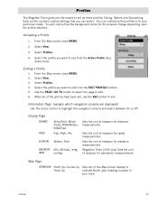
...Magellan Triton gives you want to fit your track. Each profile contains custom settings that the background colors for speed measurements. You can select. Activating a Profile 1. Information Page (assigns which navigation screens are displayed) Use the cursor control to edit. 6. Sets the unit of measure for elevation measurements. (Magellan Triton... of measure for barometric measurements. You will notice that you want to edit from the Active Profile drop- Hiking, Marine and Geocaching. Use the PAGE / GO TO button to select the page to highlight the navigation screens and...
...Magellan Triton gives you want to fit your track. Each profile contains custom settings that the background colors for speed measurements. You can select. Activating a Profile 1. Information Page (assigns which navigation screens are displayed) Use the cursor control to edit. 6. Sets the unit of measure for elevation measurements. (Magellan Triton... of measure for barometric measurements. You will notice that you want to edit from the Active Profile drop- Hiking, Marine and Geocaching. Use the PAGE / GO TO button to select the page to highlight the navigation screens and...
Manual - English
Page 40
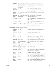
... alert you when the Magellan Triton loses GPS signals. Low, Medium, High Sets the amount of detailed information that the Magellan Triton will alert you to be off course before the off . Sets distance that the Magellan Triton will alert you approach a waypoint. Sensors Page (Magellan Triton 2000) ELECTRONIC COMPASS BAROMETER.... Off, Icons Only, Icons Sets how waypoints are and Names displayed on the map or not. Off, On Sets if Track Lines are displayed on the map. BEEPER MODE Keys Only, Alarms Only, Keys & Alarms OFF COURSE Various ARRIVAL WAYPOINT PROXIMITY ...
... alert you when the Magellan Triton loses GPS signals. Low, Medium, High Sets the amount of detailed information that the Magellan Triton will alert you to be off course before the off . Sets distance that the Magellan Triton will alert you approach a waypoint. Sensors Page (Magellan Triton 2000) ELECTRONIC COMPASS BAROMETER.... Off, Icons Only, Icons Sets how waypoints are and Names displayed on the map or not. Off, On Sets if Track Lines are displayed on the map. BEEPER MODE Keys Only, Alarms Only, Keys & Alarms OFF COURSE Various ARRIVAL WAYPOINT PROXIMITY ...

Manual - English
Page 59
... you have just taken. From the Map screen press MENU. 2. Select View. 3. Activating a Trail 1. Tip: Whenever beginning a hike that they are displayed on and computing your position, the Magellan Triton automatically drops electronic breadcrumbs to follow the steps provided here. 1. Select Save Track. 5. Select Trail. 4. Use the keyboard to save the trail. Since the...
... you have just taken. From the Map screen press MENU. 2. Select View. 3. Activating a Trail 1. Tip: Whenever beginning a hike that they are displayed on and computing your position, the Magellan Triton automatically drops electronic breadcrumbs to follow the steps provided here. 1. Select Save Track. 5. Select Trail. 4. Use the keyboard to save the trail. Since the...
Manual - English
Page 62
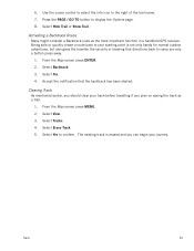
... a route back to your journey. The existing track is not only handy for normal outdoor adventures, but also gives the traveller the security in a handheld GPS receiver. Clearing Track As mentioned earlier, you should clear your track before travelling if you can begin your starting point... is erased and you plan on saving the track as the most important function in knowing that the...
... a route back to your journey. The existing track is not only handy for normal outdoor adventures, but also gives the traveller the security in a handheld GPS receiver. Clearing Track As mentioned earlier, you should clear your track before travelling if you can begin your starting point... is erased and you plan on saving the track as the most important function in knowing that the...
