
Triton User Manual Addendum - English, French, Spanish
Page 1
... navigational screen. When you want to pause the recording of your track again, select ENTER again and select "Resume Track Record". The most noticeable change in the software is equal to or higher then the ones listed. Press ESC when you are ready to save the track to connect the start and end points of the User Grid. On the contextual menu, select "Start New Track". Select "Pause Track Record". Triton User Manual Addendum This addendum applies to Triton GPS receivers...
... navigational screen. When you want to pause the recording of your track again, select ENTER again and select "Resume Track Record". The most noticeable change in the software is equal to or higher then the ones listed. Press ESC when you are ready to save the track to connect the start and end points of the User Grid. On the contextual menu, select "Start New Track". Select "Pause Track Record". Triton User Manual Addendum This addendum applies to Triton GPS receivers...

Triton User Manual Addendum - English, French, Spanish
Page 2
... location you select, either by entering the coordinates or by panning on the map. Select View > Settings > Navigation. When setting a custom position, the GPS portion of the entire route. You can set a user-defined map datum for your mind, you activate a route with options to view map areas other then your active route. Additionally, if you change your Triton. Set Custom Position. Press ENTER. Select View > Settings > Navigation. Set the coordinates or select the position from any navigational screen. With the point defined, select "Enable Custom Position". User...
... location you select, either by entering the coordinates or by panning on the map. Select View > Settings > Navigation. When setting a custom position, the GPS portion of the entire route. You can set a user-defined map datum for your mind, you activate a route with options to view map areas other then your active route. Additionally, if you change your Triton. Set Custom Position. Press ENTER. Select View > Settings > Navigation. Set the coordinates or select the position from any navigational screen. With the point defined, select "Enable Custom Position". User...

Manual - English
Page 2
... Corporation. USE CARE The Global Positioning System (GPS) is operated by poor satellite geometry and obstructions, like buildings and large trees. USE GOOD JUDGEMENT This product is an excellent navigation aid, but does not replace the need for navigating. the use without the prior written permission of non-Magellan cables and antennas may be injured. Never rely solely on the Magellan Triton while driving...
... Corporation. USE CARE The Global Positioning System (GPS) is operated by poor satellite geometry and obstructions, like buildings and large trees. USE GOOD JUDGEMENT This product is an excellent navigation aid, but does not replace the need for navigating. the use without the prior written permission of non-Magellan cables and antennas may be injured. Never rely solely on the Magellan Triton while driving...
Manual - English
Page 5
...4 Setting the Time Zone 4 Changing Languages 5 Sleep Mode (Backlight Timer 5 Waking up the Triton from Sleep Mode 5 Setting the Backlight Timer 5 Automatic Power Off 6 Setting the Power Off Timer interval 6 Flashlight ...7 Turning the flashlight on or off 7 Menus ...7 Accessing the Main Menu 7 Navigation Screens 8 Accessing the Map Screen Contextual Menu 8 Accessing the Speedometer Contextual Menu 8 Data Fields ...9 Customizing the Data Field for the Map Screen 9 Customizing the Data Field for the Large Data, Compass or Satellite Status Screen .. 9 Selecting Maps ...9 Battery Life...
...4 Setting the Time Zone 4 Changing Languages 5 Sleep Mode (Backlight Timer 5 Waking up the Triton from Sleep Mode 5 Setting the Backlight Timer 5 Automatic Power Off 6 Setting the Power Off Timer interval 6 Flashlight ...7 Turning the flashlight on or off 7 Menus ...7 Accessing the Main Menu 7 Navigation Screens 8 Accessing the Map Screen Contextual Menu 8 Accessing the Speedometer Contextual Menu 8 Data Fields ...9 Customizing the Data Field for the Map Screen 9 Customizing the Data Field for the Large Data, Compass or Satellite Status Screen .. 9 Selecting Maps ...9 Battery Life...
Manual - English
Page 6
... Map Screen Data Fields 21 Saving Your Current Position as a Waypoint 21 Saving a Position as a Waypoint using Pan 21 Displaying Best Fishing and Hunting Times 22 Displaying Solar and Lunar Rise and Set Times 22 Creating a Go To Route from the Map Screen 23 Viewing Waypoint Details from the Map Screen 23 Creating a Backtrack Route 24 Changing Map Options 24 Changing Map Units of Measure 25 Changing Map Units of Measure 26 Using the Keyboard ...27 Date Entry ...30 Text Size Limitations 30 Page Selection ...30 Profiles ...31 Activating a Profile 31 Editing a Profile 31 Information...
... Map Screen Data Fields 21 Saving Your Current Position as a Waypoint 21 Saving a Position as a Waypoint using Pan 21 Displaying Best Fishing and Hunting Times 22 Displaying Solar and Lunar Rise and Set Times 22 Creating a Go To Route from the Map Screen 23 Viewing Waypoint Details from the Map Screen 23 Creating a Backtrack Route 24 Changing Map Options 24 Changing Map Units of Measure 25 Changing Map Units of Measure 26 Using the Keyboard ...27 Date Entry ...30 Text Size Limitations 30 Page Selection ...30 Profiles ...31 Activating a Profile 31 Editing a Profile 31 Information...
Manual - English
Page 7
... the Map Screen 35 Creating a Custom Waypoint Using the Triton Menu 36 Viewing Waypoints 36 Viewing a Saved Waypoint 36 Editing Waypoints 37 Editing a Saved Waypoint 37 Deleting a Saved Waypoint 37 Deleting a Saved Waypoint (Alternate Method 37 Deleting All Saved Waypoints 38 Duplicating a Saved Waypoint 38 Settings ...39 Customizing Navigation Settings 39 Setting Volume and Brightness 39 View Memory Usage 39 Clearing Memory 40 Restoring Factory Settings 40 Setting Connectivity 40 Getting Software Version Information 41 Viewing Copyright Information 41 Personalizing Magellan...
... the Map Screen 35 Creating a Custom Waypoint Using the Triton Menu 36 Viewing Waypoints 36 Viewing a Saved Waypoint 36 Editing Waypoints 37 Editing a Saved Waypoint 37 Deleting a Saved Waypoint 37 Deleting a Saved Waypoint (Alternate Method 37 Deleting All Saved Waypoints 38 Duplicating a Saved Waypoint 38 Settings ...39 Customizing Navigation Settings 39 Setting Volume and Brightness 39 View Memory Usage 39 Clearing Memory 40 Restoring Factory Settings 40 Setting Connectivity 40 Getting Software Version Information 41 Viewing Copyright Information 41 Personalizing Magellan...
Manual - English
Page 9
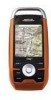
... SD card and enjoy a customized soundtrack as they become available. Audio jack - Plug in the Magellan Triton or, for additional information and tips on the use - Ease-of-use of your boat or off-road vehicle for improved accuracy. 3-axis electronic compass (Triton 2000 only) - Overview Thank you for clear private listening. The Magellan Triton was designed for first time GPS receiver users while still keeping all the features...
... SD card and enjoy a customized soundtrack as they become available. Audio jack - Plug in the Magellan Triton or, for additional information and tips on the use - Ease-of-use of your boat or off-road vehicle for improved accuracy. 3-axis electronic compass (Triton 2000 only) - Overview Thank you for clear private listening. The Magellan Triton was designed for first time GPS receiver users while still keeping all the features...
Manual - English
Page 13
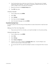
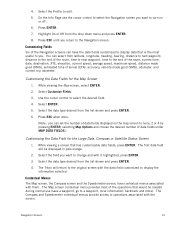
... long as the Triton is turned on. From the Map screen, press MENU. 2. Fundamentals 5 Select View. 3. Setting the Backlight Timer 1. 6. If you travel to an area with a different time zone, you want the backlight to the previous setting. Changing Languages 1. Select Settings. 4. Select View. 3. From the drop-down and select Language. 5. Press ESC when done. Sleep Mode (Backlight Timer) To conserve battery life the Triton will need to the desired interval. 6. Select Volume & Brightness. 5. Using the cursor control, highlight the Backlight Timer slider. Use...
... long as the Triton is turned on. From the Map screen, press MENU. 2. Fundamentals 5 Select View. 3. Setting the Backlight Timer 1. 6. If you travel to an area with a different time zone, you want the backlight to the previous setting. Changing Languages 1. Select Settings. 4. Select View. 3. From the drop-down and select Language. 5. Press ESC when done. Sleep Mode (Backlight Timer) To conserve battery life the Triton will need to the desired interval. 6. Select Volume & Brightness. 5. Using the cursor control, highlight the Backlight Timer slider. Use...
Manual - English
Page 15
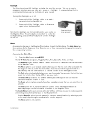
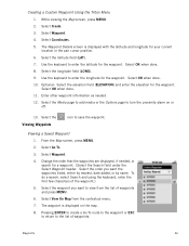
... saved previously. Fundamentals 7 To conserve battery life it as the destination waypoint for at least 4 seconds to follow from your Magellan Triton. Accessing the Main Menu 1. The Route option displays routes that can be used in a future update. From the Map Screen, press MENU. The Place option is recommended that you would like to turn the flashlight on. 2. The Trips option will be saved by entering the coordinates for information...
... saved previously. Fundamentals 7 To conserve battery life it as the destination waypoint for at least 4 seconds to follow from your Magellan Triton. Accessing the Main Menu 1. The Route option displays routes that can be used in a future update. From the Map Screen, press MENU. The Place option is recommended that you would like to turn the flashlight on. 2. The Trips option will be saved by entering the coordinates for information...
Manual - English
Page 16
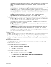
... button. (There are installed), that can : Reset Odometer, Reset Trip Odometer, Reset Speed. 2. Use Settings to access navigation settings, adjust volume and brightness, select connectivity, view memory details, as well as solar and lunar rise and set times for information on the map or by selecting a point on updates to close the contextual menu. These routes generally begin at www.magellangps.com for your present position, by entering the coordinates of the support functions and tools found in the Magellan Triton from earlier trips, or waypoints...
... button. (There are installed), that can : Reset Odometer, Reset Trip Odometer, Reset Speed. 2. Use Settings to access navigation settings, adjust volume and brightness, select connectivity, view memory details, as well as solar and lunar rise and set times for information on the map or by selecting a point on updates to close the contextual menu. These routes generally begin at www.magellangps.com for your present position, by entering the coordinates of the support functions and tools found in the Magellan Triton from earlier trips, or waypoints...
Manual - English
Page 21
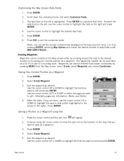
..., bearing, distance to next waypoint, distance to the end of the route, time to next waypoint, time to select the Navigation screen you can select from the drop down menu and press ENTER. 8. While viewing the Map screen, select ENTER. 2. Customizing Fields Six of arrival (ETA), accuracy, velocity made good (VMG), odometer, and current trip odometer. Contextual Menus The Map screen, the Compass screen and the Speedometer screen, have the data fields customized to a waypoint, local information, backtrack and more). 4. On the Info Page use (save a waypoint, go to display...
..., bearing, distance to next waypoint, distance to the end of the route, time to next waypoint, time to select the Navigation screen you can select from the drop down menu and press ENTER. 8. While viewing the Map screen, select ENTER. 2. Customizing Fields Six of arrival (ETA), accuracy, velocity made good (VMG), odometer, and current trip odometer. Contextual Menus The Map screen, the Compass screen and the Speedometer screen, have the data fields customized to a waypoint, local information, backtrack and more). 4. On the Info Page use (save a waypoint, go to display...
Manual - English
Page 22
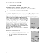
... Position Destination Line. The Map screen can display up to hide all the data fields. The Position Destination Line is displayed on the map as an orange line with map detail information provided from the detailed map will be displayed.) Waypoints (user-created or preloaded in the map) will be displayed. 3. From the Map screen, press ENTER. Map Screen The Map screen displays your movements (track) is a straight line displaying LOS (line of sight) from your current location to indicate north...
... Position Destination Line. The Map screen can display up to hide all the data fields. The Position Destination Line is displayed on the map as an orange line with map detail information provided from the detailed map will be displayed.) Waypoints (user-created or preloaded in the map) will be displayed. 3. From the Map screen, press ENTER. Map Screen The Map screen displays your movements (track) is a straight line displaying LOS (line of sight) from your current location to indicate north...
Manual - English
Page 24
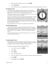
...by default but can be turned on following these instructions. From the Map screen, press MENU. 2. 1. The Strip Compass Screen The Strip Compass screen presents the compass information using the instructions below. The Strip Compass screen is active) in another familiar format. Turning on the standard compass screen. Select Profiles. 4. Select View. 3. The Compass Screen The Compass screen displays information about your position and heading. Outside the compass are customizable and can be set to your next destination waypoint if you are moving . The bearing icon...
...by default but can be turned on following these instructions. From the Map screen, press MENU. 2. 1. The Strip Compass Screen The Strip Compass screen presents the compass information using the instructions below. The Strip Compass screen is active) in another familiar format. Turning on the standard compass screen. Select Profiles. 4. Select View. 3. The Compass Screen The Compass screen displays information about your position and heading. Outside the compass are customizable and can be set to your next destination waypoint if you are moving . The bearing icon...

Manual - English
Page 28
... your current position.) Computed Route Indicator (Line of sight pointer to next destination from where the route originated.) Current Route Indicator (Line displaying line of sight to the destination from the Waypoint Information screen.) Map Screen 20 Map Screen Overview Battery Level Time of Day GPS Signal Strength North Indicator Data Fields Map Scale Pan Mode Map Legend Present Position Cursor (Points in the receiver. This makes understanding the Map screen and all of the functions that can assign a different icon from current location.) Track (Displays...
... your current position.) Computed Route Indicator (Line of sight pointer to next destination from where the route originated.) Current Route Indicator (Line displaying line of sight to the destination from the Waypoint Information screen.) Map Screen 20 Map Screen Overview Battery Level Time of Day GPS Signal Strength North Indicator Data Fields Map Scale Pan Mode Map Legend Present Position Cursor (Points in the receiver. This makes understanding the Map screen and all of the functions that can assign a different icon from current location.) Track (Displays...
Manual - English
Page 29
... pan icon will appear. 2. Select Create Waypoint. 5. Map Screen 21 Press ESC to exit the customize mode. (Note: you want to save to disk button (highlighted in the screen to none, 2 or 4 by pressing ENTER, selecting Map Options and choose the desired number of a multileg route. Use the cursor control to edit and press ENTER. Use the cursor control LEFT or RIGHT to select the page you can set the number of data fields displayed on...
... pan icon will appear. 2. Select Create Waypoint. 5. Map Screen 21 Press ESC to exit the customize mode. (Note: you want to save to disk button (highlighted in the screen to none, 2 or 4 by pressing ENTER, selecting Map Options and choose the desired number of a multileg route. Use the cursor control to edit and press ENTER. Use the cursor control LEFT or RIGHT to select the page you can set the number of data fields displayed on...
Manual - English
Page 41
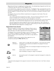
... the Triton memory. You cannot add Place waypoints but they are the key to the waypoint from your home to your current location. Waypoint Information Media Used to enter data, modify existing data, add media or set alarm requirements for the waypoint. In its simplest form, a waypoint is a point on geocaching, but you enter a unique name for each waypoint. With information on the direction and distance to navigating and creating routes. This screen provides a way to enter or modify data for the waypoint. Used...
... the Triton memory. You cannot add Place waypoints but they are the key to the waypoint from your home to your current location. Waypoint Information Media Used to enter data, modify existing data, add media or set alarm requirements for the waypoint. In its simplest form, a waypoint is a point on geocaching, but you enter a unique name for each waypoint. With information on the direction and distance to navigating and creating routes. This screen provides a way to enter or modify data for the waypoint. Used...

Manual - English
Page 42
... page to add media or the Options page to the location on or off. Select Create Waypoint. 3. Edit the waypoint information as needed . 6. While viewing the Map screen, press MENU. 2. While viewing the Map screen, use the arrow keys to move the pan cursor to turn the proximity alarm on or off . 8. Edit the waypoint information as needed . 7. Select Waypoint. 4. The Waypoint Details screen is displayed with the latitude, longitude and elevation for the pan cursor position. 5. Select Create Waypoint. 4. Creating Waypoints Creating a Current Location Waypoint from the Map Screen...
... page to add media or the Options page to the location on or off. Select Create Waypoint. 3. Edit the waypoint information as needed . 6. While viewing the Map screen, press MENU. 2. While viewing the Map screen, use the arrow keys to move the pan cursor to turn the proximity alarm on or off . 8. Edit the waypoint information as needed . 7. Select Waypoint. 4. The Waypoint Details screen is displayed with the latitude, longitude and elevation for the pan cursor position. 5. Select Create Waypoint. 4. Creating Waypoints Creating a Current Location Waypoint from the Map Screen...
Manual - English
Page 44
... Map screen, press MENU. 2. Select Coordinates. 5. Optional: Select the elevation field (ELEVATION) and enter the elevation for the waypoint. Select the Viewing Waypoints icon to turn the proximity alarm on the map. 8. Change the order that the waypoints are displayed, if needed . 12. To do a search, select Search and using the keyboard, enter the first few characters of waypoints. Select OK when done. 8. Select the longitude field (LONG). 9. Viewing a Saved Waypoint 1. Select the Media page to add media or the Options page to save the waypoint. The waypoint...
... Map screen, press MENU. 2. Select Coordinates. 5. Optional: Select the elevation field (ELEVATION) and enter the elevation for the waypoint. Select the Viewing Waypoints icon to turn the proximity alarm on the map. 8. Change the order that the waypoints are displayed, if needed . 12. To do a search, select Search and using the keyboard, enter the first few characters of waypoints. Select OK when done. 8. Select the longitude field (LONG). 9. Viewing a Saved Waypoint 1. Select the Media page to add media or the Options page to save the waypoint. The waypoint...
Manual - English
Page 51
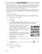
...). 6. From the Map screen, press MENU. 2. Select Create. 3. Select Geocache. 4. Select from the SD card installed in finding the cache. Geocache information includes Difficulty (1 through 5 with 5 being the most difficult), Terrain (1 though 5 with GPS users. Press the PAGE / GO TO button to save Geocaching 43 Press PAGE / GO TO to add media (image) from Current Location, Point on geocaching for others to the VantagePoint software and uploading it into their Magellan Triton. From the Map screen, press MENU. 2.
...). 6. From the Map screen, press MENU. 2. Select Create. 3. Select Geocache. 4. Select from the SD card installed in finding the cache. Geocache information includes Difficulty (1 through 5 with 5 being the most difficult), Terrain (1 though 5 with GPS users. Press the PAGE / GO TO button to save Geocaching 43 Press PAGE / GO TO to add media (image) from Current Location, Point on geocaching for others to the VantagePoint software and uploading it into their Magellan Triton. From the Map screen, press MENU. 2.

Manual - English
Page 56
... select the green checkmark. The Map screen is on Map: Use the arrow keys to scroll around the map until the route is correct, select Done in step 4 apply. 8. Routes 48 When the Waypoint Details page is displayed with a graphical representation of saved geocache waypoints and press ENTER. Select a waypoint from the list of the route. 10. The Route Create screen is displayed, make necessary changes. Confirm the deletion. (This does not remove the waypoint from the Triton's memory...
... select the green checkmark. The Map screen is on Map: Use the arrow keys to scroll around the map until the route is correct, select Done in step 4 apply. 8. Routes 48 When the Waypoint Details page is displayed with a graphical representation of saved geocache waypoints and press ENTER. Select a waypoint from the list of the route. 10. The Route Create screen is displayed, make necessary changes. Confirm the deletion. (This does not remove the waypoint from the Triton's memory...


