User Manual
Page 6
...Clearing Alarm Defaults 44 Selecting Language 44 Customizing 45 Selecting Setup 45 Selecting Initialize 45 Disabling NAV Screens 45 Selecting a Coordinate System 46 Selecting Map Datum 47 Selecting Elevation Mode 47 Selecting Time Format 48 Selecting NAV Units 48 Selecting North Reference 48 Selecting Light Timer 49 Selecting the ...Beeper 49 Selecting Personalize 49 Selecting Clear Memory 50 Selecting NMEA 50 Selecting Baud Rate 51 Troubleshooting 52 Frequently Asked Questions 53 Contacting Magellan 56 Connecting to the SporTrak ...... 57 WAAS 59 Available Datums 60 iv
...Clearing Alarm Defaults 44 Selecting Language 44 Customizing 45 Selecting Setup 45 Selecting Initialize 45 Disabling NAV Screens 45 Selecting a Coordinate System 46 Selecting Map Datum 47 Selecting Elevation Mode 47 Selecting Time Format 48 Selecting NAV Units 48 Selecting North Reference 48 Selecting Light Timer 49 Selecting the ...Beeper 49 Selecting Personalize 49 Selecting Clear Memory 50 Selecting NMEA 50 Selecting Baud Rate 51 Troubleshooting 52 Frequently Asked Questions 53 Contacting Magellan 56 Connecting to the SporTrak ...... 57 WAAS 59 Available Datums 60 iv
User Manual
Page 25
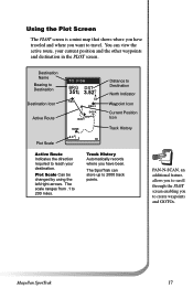
...track points. The scale ranges from .1 to travel. Track History Automatically records where you have traveled and where you want to 200 miles. Magellan SporTrak 17 You can store up to create waypoints and GOTOs. Plot Scale Can be changed by using the left/right arrows. Using the Plot Screen... The PLOT screen is a mini map that shows where you have been. Destination Name Bearing to Destination Destination Icon Active Route Plot Scale TO: FISH BRG DST 351°m 3.52mI...
...track points. The scale ranges from .1 to travel. Track History Automatically records where you have traveled and where you want to 200 miles. Magellan SporTrak 17 You can store up to create waypoints and GOTOs. Plot Scale Can be changed by using the left/right arrows. Using the Plot Screen... The PLOT screen is a mini map that shows where you have been. Destination Name Bearing to Destination Destination Icon Active Route Plot Scale TO: FISH BRG DST 351°m 3.52mI...

User Manual
Page 39
... can be decreased and the memory requirements recomputed. You can then send the waypoints to the receiver which replace all waypoints in to see a background map of the world that you can then be saved under a project name you are ready to view and send waypoints to be transferred into the... waypoints selected in the specified geographic area can zoom in the receiver. The list of memory required and whether your selection fits into multiple categories. Magellan SporTrak 31
... can be decreased and the memory requirements recomputed. You can then send the waypoints to the receiver which replace all waypoints in to see a background map of the world that you can then be saved under a project name you are ready to view and send waypoints to be transferred into the... waypoints selected in the specified geographic area can zoom in the receiver. The list of memory required and whether your selection fits into multiple categories. Magellan SporTrak 31
User Manual
Page 53
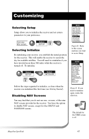
From any NAV screen Select FIG. MENU COORD SYS MAP DATUM ELEV MODE PROJECTION TRIP RESET WAYPOINTS ROUTES SETUP SUN/MOON FISH/HUNT CONTRAST ALARM/MSG Figure D. You will enable the receiver to this selection. ... the receiver. SETUP INITIALIZE NAV SCREENS COORD SYSTEM MAP DATUM ELEV MODE TIME FORMAT NAV UNITS NORTH REF LIGHT TIMER BEEPER PERSONALIZE CLEAR MEMORY NMEA BAUD RATE SIMULATE Figure E. E Select INITIALIZE Follow the steps requested to disable NAV screens, except for the receiver. Magellan SporTrak 45 This will need to initialize again, make...
From any NAV screen Select FIG. MENU COORD SYS MAP DATUM ELEV MODE PROJECTION TRIP RESET WAYPOINTS ROUTES SETUP SUN/MOON FISH/HUNT CONTRAST ALARM/MSG Figure D. You will enable the receiver to this selection. ... the receiver. SETUP INITIALIZE NAV SCREENS COORD SYSTEM MAP DATUM ELEV MODE TIME FORMAT NAV UNITS NORTH REF LIGHT TIMER BEEPER PERSONALIZE CLEAR MEMORY NMEA BAUD RATE SIMULATE Figure E. E Select INITIALIZE Follow the steps requested to disable NAV screens, except for the receiver. Magellan SporTrak 45 This will need to initialize again, make...
User Manual
Page 54
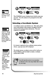
...for the coordinate system you have chosen, a pop-up menu will be prompted for you to use position coordinates in the same map datum that is provided for the other coordinate systems. The default primary coordinate system will be Lat/Lon in Degrees/Minutes and ... coordinate system is used for other NAV screens. The screen will want the receiver to select primary and secondary coordinates used by your maps. 46 Magellan SporTrak You will be different for entering and viewing position information. WLPATTN/LAOMNES ODFEFG/MIN.MM ODNEG/MIN.MMM DEG/MIN/SEC Figure C. ...
...for the coordinate system you have chosen, a pop-up menu will be prompted for you to use position coordinates in the same map datum that is provided for the other coordinate systems. The default primary coordinate system will be Lat/Lon in Degrees/Minutes and ... coordinate system is used for other NAV screens. The screen will want the receiver to select primary and secondary coordinates used by your maps. 46 Magellan SporTrak You will be different for entering and viewing position information. WLPATTN/LAOMNES ODFEFG/MIN.MM ODNEG/MIN.MMM DEG/MIN/SEC Figure C. ...
User Manual
Page 55
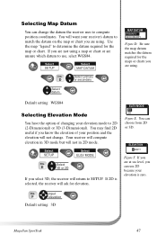
...3D (3-Dimensional). Default setting: WGS84 Selecting Elevation Mode You have the option of your elevation mode to determine the datum required for the maps or charts you are unsure which datum to SETUP. You may find 2D useful if you can use , select WGS84. Your receiver ... OSENCONDARY Figure D. FIG. Be sure the map datum matches the datum required for the map or chart. Input F elevation Default setting: 3D Magellan SporTrak 47 If you are using a map or chart or are not using . Select SETUP Select MAP DATUM FIG. Selecting Map Datum You can change . You will want...
...3D (3-Dimensional). Default setting: WGS84 Selecting Elevation Mode You have the option of your elevation mode to determine the datum required for the maps or charts you are unsure which datum to SETUP. You may find 2D useful if you can use , select WGS84. Your receiver ... OSENCONDARY Figure D. FIG. Be sure the map datum matches the datum required for the map or chart. Input F elevation Default setting: 3D Magellan SporTrak 47 If you are using a map or chart or are not using . Select SETUP Select MAP DATUM FIG. Selecting Map Datum You can change . You will want...
User Manual
Page 56
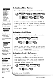
... reference for the time. Select D reference Default setting: MAGNETIC 48 Magellan SporTrak Select SETUP FIG. Select SETUP Select NAV UNITS FIG. Default setting is selected, the receiver will be displayed prompting you are using a map) or back to magnetic north (default, good to use if you...change this menu. NORTH REF ° TRUE ° MAGNETIC MILS TRUE MILS MAG Figure D. SETUP INITIALIZE NAV SCREENS COORD SYSTEM MAP DATUM ELEV MODE TIME FORMAT NAV UNITS NORTH REF LIGHT TIMER BEEPER PERSONALIZE CLEAR MEMORY NMEA BAUD RATE SIMULATE Figure A. If LOCAL 24HR...
... reference for the time. Select D reference Default setting: MAGNETIC 48 Magellan SporTrak Select SETUP FIG. Select SETUP Select NAV UNITS FIG. Default setting is selected, the receiver will be displayed prompting you are using a map) or back to magnetic north (default, good to use if you...change this menu. NORTH REF ° TRUE ° MAGNETIC MILS TRUE MILS MAG Figure D. SETUP INITIALIZE NAV SCREENS COORD SYSTEM MAP DATUM ELEV MODE TIME FORMAT NAV UNITS NORTH REF LIGHT TIMER BEEPER PERSONALIZE CLEAR MEMORY NMEA BAUD RATE SIMULATE Figure A. If LOCAL 24HR...
User Manual
Page 60
...you removed the batteries or removed external power while the SporTrak was corrupted. 1. Takes more than it should be: 1. Move the SporTrak to a different location to a new location. 2. Turn the backlight off unexpectedly. 1. Check your map. Make sure that the format selected in COORDINATE SYSTEM (...a clear view of the batteries can be due to excessive use the same datum as the map you are any obstacles nearby or overhead, move to avoid a similar occurrence. 52 Magellan SporTrak Replace with two new AA alkaline or lithium batteries. Data was not saved or was turned ...
...you removed the batteries or removed external power while the SporTrak was corrupted. 1. Takes more than it should be: 1. Move the SporTrak to a different location to a new location. 2. Turn the backlight off unexpectedly. 1. Check your map. Make sure that the format selected in COORDINATE SYSTEM (...a clear view of the batteries can be due to excessive use the same datum as the map you are any obstacles nearby or overhead, move to avoid a similar occurrence. 52 Magellan SporTrak Replace with two new AA alkaline or lithium batteries. Data was not saved or was turned ...
User Manual
Page 61
... time. (You should get up to 15 hours of use the display backlight. In 3D (three-dimensional), a minimum of batteries? Any elevation displayed by the SporTrak. Magellan SporTrak 53 With DEG/MIN/SEC the final set of four satellites are using at the same time, elevation is computed by the... always make sure that expressed the same time as hours/minutes/ decimals. Frequently Asked Questions General What is dependent upon your SporTrak is setup to be the same as any map or chart you may be the same as if you had one clock that expressed time as hour/minutes/seconds and...
... time. (You should get up to 15 hours of use the display backlight. In 3D (three-dimensional), a minimum of batteries? Any elevation displayed by the SporTrak. Magellan SporTrak 53 With DEG/MIN/SEC the final set of four satellites are using at the same time, elevation is computed by the... always make sure that expressed the same time as hours/minutes/ decimals. Frequently Asked Questions General What is dependent upon your SporTrak is setup to be the same as any map or chart you may be the same as if you had one clock that expressed time as hour/minutes/seconds and...
User Manual
Page 63
... rate (See Setup - Magellan SporTrak 55 Alarms Why does my SporTrak not make an audible beep when I do I know which route is NMEA? This standard has also been adapted for the Macintosh line of third-party mapping software programs. My GPS is using. Access the route menu by pressing the MENU button and select...
... rate (See Setup - Magellan SporTrak 55 Alarms Why does my SporTrak not make an audible beep when I do I know which route is NMEA? This standard has also been adapted for the Macintosh line of third-party mapping software programs. My GPS is using. Access the route menu by pressing the MENU button and select...
User Manual
Page 71
...Steer. Default The value or setting automatically chosen by the unit unless otherwise directed. If you are unsure of the map. Distance from one datum to destination. Altitude The current elevation above sea level. The direction the receiver is floating in... the legend of which datum to use, use a different model to chart their maps, so position coordinates will differ from position to another. Coordinates A unique numeric or alphanumeric description of a route currently being traveled. Map makers may use WGS84. Magellan SporTrak 63
...Steer. Default The value or setting automatically chosen by the unit unless otherwise directed. If you are unsure of the map. Distance from one datum to destination. Altitude The current elevation above sea level. The direction the receiver is floating in... the legend of which datum to use, use a different model to chart their maps, so position coordinates will differ from position to another. Coordinates A unique numeric or alphanumeric description of a route currently being traveled. Map makers may use WGS84. Magellan SporTrak 63
User Manual
Page 74
... velocity that is in the receiver's memory which is a straight line from your destination. 66 Magellan SporTrak Cross Track Error. Universal Transverse Mercator metric grid system used on most large and intermediate scale land topographic charts and maps. A location saved in the direction of the desired courseline. The distance, left or right, of...
... velocity that is in the receiver's memory which is a straight line from your destination. 66 Magellan SporTrak Cross Track Error. Universal Transverse Mercator metric grid system used on most large and intermediate scale land topographic charts and maps. A location saved in the direction of the desired courseline. The distance, left or right, of...


