User Manual
Page 2
... accuracy and maintenance of Defense civil GPS user policy and the Federal Radionavigation Plan. USE CARE The Global Positioning System (GPS) is subject to GPS satellites made by the U.S. You may be affected by United States copyright laws and international treaty provisions; Government and is operated by the U.S. Magellan™ and SporTrak™ are reserved by Thales Navigation and/or its suppliers. * * * No part...
... accuracy and maintenance of Defense civil GPS user policy and the Federal Radionavigation Plan. USE CARE The Global Positioning System (GPS) is subject to GPS satellites made by the U.S. You may be affected by United States copyright laws and international treaty provisions; Government and is operated by the U.S. Magellan™ and SporTrak™ are reserved by Thales Navigation and/or its suppliers. * * * No part...
User Manual
Page 4
... the Compass Screen 15 Using the NAV 2 Screen 16 Customizing the NAV 2 Screen 16 Using the Plot Screen 17 Selecting PAN-N-SCAN 18 Setting Track History 18 Clearing Track History 18 Setting Up the Plotter 19 Setting Hide Data/Show Data 20 Using the Road Screen 21 Customizing the Road Screen 21 Using the Speed Screen 22 Resetting the Odometer 22 Resetting the Trip Odometer 23 Setting the Speed Average 23 Using the Time Screen 24 Selecting Time Format 24 Resetting Elapsed Time 25 Reference 26 Working with Waypoints 27 Creating a User Waypoint 28 Editing a User Waypoint 28...
... the Compass Screen 15 Using the NAV 2 Screen 16 Customizing the NAV 2 Screen 16 Using the Plot Screen 17 Selecting PAN-N-SCAN 18 Setting Track History 18 Clearing Track History 18 Setting Up the Plotter 19 Setting Hide Data/Show Data 20 Using the Road Screen 21 Customizing the Road Screen 21 Using the Speed Screen 22 Resetting the Odometer 22 Resetting the Trip Odometer 23 Setting the Speed Average 23 Using the Time Screen 24 Selecting Time Format 24 Resetting Elapsed Time 25 Reference 26 Working with Waypoints 27 Creating a User Waypoint 28 Editing a User Waypoint 28...
User Manual
Page 9
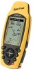
... Started chapter first as it prepares your receiver for Thales Navigation. The Reference section contains information to you begin, make sure that your package includes all of the Magellan SporTrak GPS receiver. It is a trademark name for use . The Basic Operation chapter describes the features found in 1989, Magellan has led the way with key sequences rather than spending hours reading the user's manual. Before you . . Magellan SporTrak...
... Started chapter first as it prepares your receiver for Thales Navigation. The Reference section contains information to you begin, make sure that your package includes all of the Magellan SporTrak GPS receiver. It is a trademark name for use . The Basic Operation chapter describes the features found in 1989, Magellan has led the way with key sequences rather than spending hours reading the user's manual. Before you . . Magellan SporTrak...
User Manual
Page 13
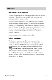
... First Time Use The final step in the Reference Section of the User Manual.) Magellan SporTrak 5 You can use . You can change the language at any time by accessing the Languages option of the Setup Menu. (See Changing Languages in setting up the process for the first time is brand new or memory has been cleared). Select Language The first time you use your position in permanent memory) to initialize the receiver . Follow these instructions to highlight the language you...
... First Time Use The final step in the Reference Section of the User Manual.) Magellan SporTrak 5 You can use . You can change the language at any time by accessing the Languages option of the Setup Menu. (See Changing Languages in setting up the process for the first time is brand new or memory has been cleared). Select Language The first time you use your position in permanent memory) to initialize the receiver . Follow these instructions to highlight the language you...
User Manual
Page 16
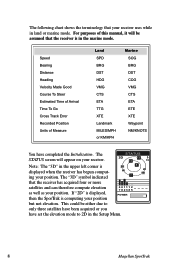
... as your receiver uses while in the marine mode. Speed Bearing Distance Heading Velocity Made Good Course To Steer Estimated Time of Arrival Time To Go Cross Track Error Recorded Position Units of this manual, it will appear on your position. This could be assumed that the receiver is computing your position 001112 782385 POWER but not elevation. The following chart shows the terminology that your position. If "2D" is displayed, then the SporTrak is...
... as your receiver uses while in the marine mode. Speed Bearing Distance Heading Velocity Made Good Course To Steer Estimated Time of Arrival Time To Go Cross Track Error Recorded Position Units of this manual, it will appear on your position. This could be assumed that the receiver is computing your position 001112 782385 POWER but not elevation. The following chart shows the terminology that your position. If "2D" is displayed, then the SporTrak is...
User Manual
Page 19
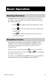
... to use the or to step through the sequence of SETUP. Navigation Screens The nine NAV (Navigation) screens (STATUS, POSITION, NAV 1, COMPASS, NAV 2, PLOT, ROAD, SPEED and TIME) provide you with necessary information you can be disabled by turning them in the NAV SCREENS portion of NAV screens. Magellan SporTrak 11 While viewing any screen. When entering data... • Use the for making selections and moving up and navigating. NAV screens can use the receiver as a navigational...
... to use the or to step through the sequence of SETUP. Navigation Screens The nine NAV (Navigation) screens (STATUS, POSITION, NAV 1, COMPASS, NAV 2, PLOT, ROAD, SPEED and TIME) provide you with necessary information you can be disabled by turning them in the NAV SCREENS portion of NAV screens. Magellan SporTrak 11 While viewing any screen. When entering data... • Use the for making selections and moving up and navigating. NAV screens can use the receiver as a navigational...
User Manual
Page 20
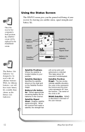
... of the user manual. 12 Magellan SporTrak Satellite Positions Where the satellite is described in the receiver. This takes about 30 seconds if uninterrupted. PSiactellite Positions WAAS Satellite Satellite Numbers STATUS 3D 12 13 N 25 8 W W 18 7 001112 782385 POWER Satellite Position Graph Satellite Signal Chart Battery Life Indicator The Battery Life Indicator was designed to your receiver by the POSITION screen. WAAS Satellite WAAS is located relative to be used with AA alkaline batteries. With AA...
... of the user manual. 12 Magellan SporTrak Satellite Positions Where the satellite is described in the receiver. This takes about 30 seconds if uninterrupted. PSiactellite Positions WAAS Satellite Satellite Numbers STATUS 3D 12 13 N 25 8 W W 18 7 001112 782385 POWER Satellite Position Graph Satellite Signal Chart Battery Life Indicator The Battery Life Indicator was designed to your receiver by the POSITION screen. WAAS Satellite WAAS is located relative to be used with AA alkaline batteries. With AA...
User Manual
Page 25
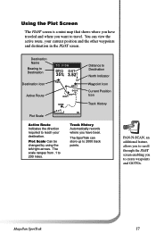
... HOME 2.0 m I Distance to Destination North Indicator Waypoint Icon Current Position Icon Track History Active Route Indicates the direction required to 200 miles. PAN-N-SCAN, an additional feature, allows you to scroll through the PLOT screen enabling you want to travel. Magellan SporTrak 17 Track History Automatically records where you have traveled and where you to 2000 track points. The SporTrak can view the active route, your destination. Plot Scale Can be changed by using the...
... HOME 2.0 m I Distance to Destination North Indicator Waypoint Icon Current Position Icon Track History Active Route Indicates the direction required to 200 miles. PAN-N-SCAN, an additional feature, allows you to scroll through the PLOT screen enabling you want to travel. Magellan SporTrak 17 Track History Automatically records where you have traveled and where you to 2000 track points. The SporTrak can view the active route, your destination. Plot Scale Can be changed by using the...
User Manual
Page 26
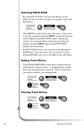
... (200 miles). Pressing MENU and selecting WPT INFO displays full information. Selecting PAN-N-SCAN By using PAN-N-SCAN, you can look ahead or review where you have been by pressing the ENTER key. In PAN-N-SCAN mode, you can zoom in by automatically storing locations, as "dropping bread crumbs" from your starting point as you travel. From PLOT screen Select TRACK HIST Change field Clearing Track History From PLOT screen Select CLR TRACK Select 18 Magellan SporTrak
... (200 miles). Pressing MENU and selecting WPT INFO displays full information. Selecting PAN-N-SCAN By using PAN-N-SCAN, you can look ahead or review where you have been by pressing the ENTER key. In PAN-N-SCAN mode, you can zoom in by automatically storing locations, as "dropping bread crumbs" from your starting point as you travel. From PLOT screen Select TRACK HIST Change field Clearing Track History From PLOT screen Select CLR TRACK Select 18 Magellan SporTrak
User Manual
Page 30
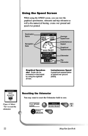
....2 K T ODOMETER 0 0 5 4 2 2n 3 m TRIP 0 5 4 2n 3m Average Speed Icon Instantaneous Speed Graphical Speedometer Odometer Trip Odometer Graphical Speedometer Scale can be increased or decreased by using the SPEED screen, you can view the graphical speedometer, odometer and trip odometer as well as the numerical bearing, course over ground and speed over ground (SOG). screen ODOM RESET A Select yes or no 22 Magellan SporTrak Using the Speed Screen While using the right/left arrows. Select "Yes" to zero. From SPEED Select FIG.
....2 K T ODOMETER 0 0 5 4 2 2n 3 m TRIP 0 5 4 2n 3m Average Speed Icon Instantaneous Speed Graphical Speedometer Odometer Trip Odometer Graphical Speedometer Scale can be increased or decreased by using the SPEED screen, you can view the graphical speedometer, odometer and trip odometer as well as the numerical bearing, course over ground and speed over ground (SOG). screen ODOM RESET A Select yes or no 22 Magellan SporTrak Using the Speed Screen While using the right/left arrows. Select "Yes" to zero. From SPEED Select FIG.
User Manual
Page 34
...-LEG ROUTE. You can create your own waypoints (known as User waypoints) or use the Setup menu to establish the options you would like to set in the receiver's memory (NonUser waypoints). These functions will help you navigate using your receiver. 26 Magellan SporTrak The Working with Routes section tells you how to use the waypoints already in your receiver. Customizing allows you to create, edit, delete, project and sort waypoints. Now that will guide you in the receiver's memory...
...-LEG ROUTE. You can create your own waypoints (known as User waypoints) or use the Setup menu to establish the options you would like to set in the receiver's memory (NonUser waypoints). These functions will help you navigate using your receiver. 26 Magellan SporTrak The Working with Routes section tells you how to use the waypoints already in your receiver. Customizing allows you to create, edit, delete, project and sort waypoints. Now that will guide you in the receiver's memory...
User Manual
Page 36
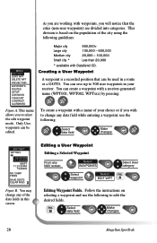
....60W 900FT 11:23:35PM 12JUN97 NO CAMP FIRES SAVE EDITS CLEAR MSG Figure B. FIG. Only User waypoints can be edited. Select B data field Make changes 28 Magellan SporTrak You may change any NAV screen Select WAYPOINTS Select User category Select waypoint Select FIG. This division is a recorded position that the cities (non-user waypoints) are working with DataSend CD. As you are divided into categories. Follow the instructions on the population of the data fields in a route or a GOTO.
....60W 900FT 11:23:35PM 12JUN97 NO CAMP FIRES SAVE EDITS CLEAR MSG Figure B. FIG. Only User waypoints can be edited. Select B data field Make changes 28 Magellan SporTrak You may change any NAV screen Select WAYPOINTS Select User category Select waypoint Select FIG. This division is a recorded position that the cities (non-user waypoints) are working with DataSend CD. As you are divided into categories. Follow the instructions on the population of the data fields in a route or a GOTO.
User Manual
Page 41
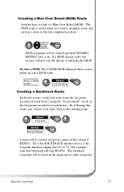
... in track history using the "bread crumbs" saved, to the first point recorded for track history. Select MOB MOB waypoints will be created and titled MOB001, MOB002 and so on. For example, your steps" back to the starting point. Select ROUTES Select BACKTRACK A route will be created and given a name in the format of BXXPxx. Creating a Man Over Board (MOB) Route Another type of route is the waypoint number ranging from the last point recorded in the menu...
... in track history using the "bread crumbs" saved, to the first point recorded for track history. Select MOB MOB waypoints will be created and titled MOB001, MOB002 and so on. For example, your steps" back to the starting point. Select ROUTES Select BACKTRACK A route will be created and given a name in the format of BXXPxx. Creating a Man Over Board (MOB) Route Another type of route is the waypoint number ranging from the last point recorded in the menu...
User Manual
Page 46
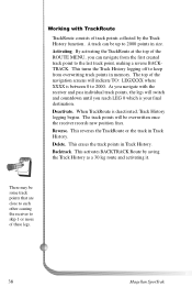
... the first created track point to 2000. Delete. By activating the TrackRoute at the top of the ROUTE MENU, you reach LEG 0 which is your final destination. Deactivate. This erases the track points in memory. There may be some track points that are close to each other causing the receiver to 2000 points in Track History. A track can navigate from overwriting track points in Track History. The top of the navigation screens will indicate...
... the first created track point to 2000. Delete. By activating the TrackRoute at the top of the ROUTE MENU, you reach LEG 0 which is your final destination. Deactivate. This erases the track points in memory. There may be some track points that are close to each other causing the receiver to 2000 points in Track History. A track can navigate from overwriting track points in Track History. The top of the navigation screens will indicate...
User Manual
Page 48
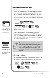
... to your preference. AUTO mode uses a speed of your actual present position. USER mode allows you to set the speed and COG to reset your receiver and how it . Selecting Contrast You may need to values you can adjust the brightness depending on your preference. screen CONTRAST B Adjust contrast 40 Magellan SporTrak Selecting the Simulate Mode The Simulate mode will help you initiated the mode) and select OFF or power the receiver off. WCPOTNNTARMAESST OFF...
... to your preference. AUTO mode uses a speed of your actual present position. USER mode allows you to set the speed and COG to reset your receiver and how it . Selecting Contrast You may need to values you can adjust the brightness depending on your preference. screen CONTRAST B Adjust contrast 40 Magellan SporTrak Selecting the Simulate Mode The Simulate mode will help you initiated the mode) and select OFF or power the receiver off. WCPOTNNTARMAESST OFF...
User Manual
Page 53
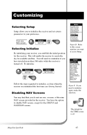
... and POSITION screens. Customizing Selecting Setup Setup allows you have the option to disable NAV screens, except for available satellites. MENU COORD SYS MAP DATUM ELEV MODE PROJECTION TRIP RESET WAYPOINTS ROUTES SETUP SUN/MOON FISH/HUNT CONTRAST ALARM/MSG Figure D. Magellan SporTrak 45 SETUP D Selecting Initialize By initializing your preference. To initialize: Select SETUP FIG. E Select INITIALIZE Follow the steps requested to initialize, as done when the receiver was initialized the first time (see Getting Started). Disabling NAV Screens...
... and POSITION screens. Customizing Selecting Setup Setup allows you have the option to disable NAV screens, except for available satellites. MENU COORD SYS MAP DATUM ELEV MODE PROJECTION TRIP RESET WAYPOINTS ROUTES SETUP SUN/MOON FISH/HUNT CONTRAST ALARM/MSG Figure D. Magellan SporTrak 45 SETUP D Selecting Initialize By initializing your preference. To initialize: Select SETUP FIG. E Select INITIALIZE Follow the steps requested to initialize, as done when the receiver was initialized the first time (see Getting Started). Disabling NAV Screens...
User Manual
Page 56
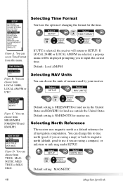
... States and KM/KPH for the time. Select SETUP Select NAV UNITS FIG. Selecting North Reference The receiver uses magnetic north as a default reference for marine use if you are selected, a pop-up menu will return to input the correct time. SETUP INITIALIZE NAV SCREENS COORD SYSTEM MAP DATUM ELEV MODE TIME FORMAT NAV UNITS NORTH REF LIGHT TIMER BEEPER PERSONALIZE CLEAR MEMORY NMEA BAUD RATE SIMULATE Figure A. You can choose from this to use . Select SETUP Select NORTH REF FIG. Select SETUP FIG. Select A TIME FORMAT FIG. TIME FORMAT LOCAL 24HR LOCAL AM/PM...
... States and KM/KPH for the time. Select SETUP Select NAV UNITS FIG. Selecting North Reference The receiver uses magnetic north as a default reference for marine use if you are selected, a pop-up menu will return to input the correct time. SETUP INITIALIZE NAV SCREENS COORD SYSTEM MAP DATUM ELEV MODE TIME FORMAT NAV UNITS NORTH REF LIGHT TIMER BEEPER PERSONALIZE CLEAR MEMORY NMEA BAUD RATE SIMULATE Figure A. You can choose from this to use . Select SETUP Select NORTH REF FIG. Select SETUP FIG. Select A TIME FORMAT FIG. TIME FORMAT LOCAL 24HR LOCAL AM/PM...
User Manual
Page 60
... using two AA alkaline or lithium batteries. 2. Position coordinates on your receiver do not match the location on your receiver. 2. The map datum is commonly caused by excessive static electricity. Data was not saved or was turned on selecting the map datum in the same format as your body. 3. Troubleshooting Receiver will not turn on and it should operate normally. Replace with two new AA alkaline or lithium batteries. See Map Datum under Reference for instructions on SporTrak turns...
... using two AA alkaline or lithium batteries. 2. Position coordinates on your receiver do not match the location on your receiver. 2. The map datum is commonly caused by excessive static electricity. Data was not saved or was turned on selecting the map datum in the same format as your body. 3. Troubleshooting Receiver will not turn on and it should operate normally. Replace with two new AA alkaline or lithium batteries. See Map Datum under Reference for instructions on SporTrak turns...
User Manual
Page 61
The accuracy for a position fix and elevation is not computed. There are different ways in expressing the coordinates computed using .) What is the same. With DEG/MIN/SEC the final set of use while the display backlight is the elevation you use the display backlight. Any elevation displayed by the SporTrak. In 3D (three-dimensional), a minimum of four satellites are using at the same time, elevation is from 0999. This duration...
The accuracy for a position fix and elevation is not computed. There are different ways in expressing the coordinates computed using .) What is the same. With DEG/MIN/SEC the final set of use while the display backlight is the elevation you use the display backlight. Any elevation displayed by the SporTrak. In 3D (three-dimensional), a minimum of four satellites are using at the same time, elevation is from 0999. This duration...
User Manual
Page 64
... 91773 ATTN: Additional information regarding software updates to your receiver to Magellan for your receiver with you. If your operation problems, please call Magellan's Technical Service at (909) 394-7070. Customers outside of Thales Navigation. 56 Magellan SporTrak Magellan™ is different, please indicate. Representatives are still unable to solve your return ship address is a trademark of the package the RMA number assigned. Faxes can be...
... 91773 ATTN: Additional information regarding software updates to your receiver to Magellan for your receiver with you. If your operation problems, please call Magellan's Technical Service at (909) 394-7070. Customers outside of Thales Navigation. 56 Magellan SporTrak Magellan™ is different, please indicate. Representatives are still unable to solve your return ship address is a trademark of the package the RMA number assigned. Faxes can be...


