
Getting Started Guide
Page 2
...Global Navigation Satellite System of any interference, including interference that operation is not provided or if the information contained in the GPS. (Note: Magellan Navigation GPS receivers use ; (ii) disasters such as UPS or FedEx when returning a product for repair. umentation. The purchaser must ...charge to provide service free-of their GPS receivers and hardware accessories to the product incurred while the product is connected. • Consult the dealer or an experienced radio/TV technician for parts or labor. Magellan Navigation reserves the right to refuse to ...
...Global Navigation Satellite System of any interference, including interference that operation is not provided or if the information contained in the GPS. (Note: Magellan Navigation GPS receivers use ; (ii) disasters such as UPS or FedEx when returning a product for repair. umentation. The purchaser must ...charge to provide service free-of their GPS receivers and hardware accessories to the product incurred while the product is connected. • Consult the dealer or an experienced radio/TV technician for parts or labor. Magellan Navigation reserves the right to refuse to ...

Getting Started Guide
Page 3
... return the product with the software (including updates thereto). This written warranty is altered or removed. For further information concerning this warranty. MAGELLAN NAVIGATION WARRANTY Magellan Navigation warrants their GPS receivers and hardware accessories to perform careful position charting and use good judgment. Insurance is advised to be warranted for the balance of defects...
... return the product with the software (including updates thereto). This written warranty is altered or removed. For further information concerning this warranty. MAGELLAN NAVIGATION WARRANTY Magellan Navigation warrants their GPS receivers and hardware accessories to perform careful position charting and use good judgment. Insurance is advised to be warranted for the balance of defects...
Getting Started Guide
Page 4
...WHICH VARY FROM LOCALITY TO LOCALITY (including Directive 1999/44/EC in the GPS or GLONASS transmission.). Examples of incidental or consequential damages, so the above limitation or exclusion may not apply to the receiver. Some national, state, or local laws do not allow the exclusion ...or limitation of such conditions include but are solely responsible for the International Sale of Goods, and shall benefit Magellan Navigation, its conflict of France, without ...
...WHICH VARY FROM LOCALITY TO LOCALITY (including Directive 1999/44/EC in the GPS or GLONASS transmission.). Examples of incidental or consequential damages, so the above limitation or exclusion may not apply to the receiver. Some national, state, or local laws do not allow the exclusion ...or limitation of such conditions include but are solely responsible for the International Sale of Goods, and shall benefit Magellan Navigation, its conflict of France, without ...

Getting Started Guide
Page 5
... 15 Panel Window (Panel 15 Statistics Window (Stats 15 GPS Status Menu Bar 16 Connecting the Internal GPS Receiver to your Application ..... 17 Step-by-Step Procedure for Establishing a GPRS Connection Via Bluetooth 18 Introduction 18 The First Time You Use MobileMapper CE 20 Step1: Ask MobileMapper CE to Be Paired with the Cell Phone 21 Step...
... 15 Panel Window (Panel 15 Statistics Window (Stats 15 GPS Status Menu Bar 16 Connecting the Internal GPS Receiver to your Application ..... 17 Step-by-Step Procedure for Establishing a GPRS Connection Via Bluetooth 18 Introduction 18 The First Time You Use MobileMapper CE 20 Step1: Ask MobileMapper CE to Be Paired with the Cell Phone 21 Step...

Getting Started Guide
Page 6
... Management 42 Power Modes 42 Turning Off MobileMapper CE Manually 43 Checking Battery Status 43 LED Indicators 43 Memory Management 43 GPS Utilities 44 DGPS Configuration 44 GPS Initialization 44 GPS Ports Configuration 45 GPS Reset 46 GPS Settings 47 GPS Status 47 Mission Planning 47 Switching Between ... Accuracy 58 General Guidelines 58 Recording Data for Post-Processing 59 Appendices 61 Updating MobileMapper CE OS Firmware 61 Updating MobileMapper CE GPS Firmware 62 About Almanac Files 64 Choosing the Appropriate Real-Time Correction Age Limit ..... 64 Assessing...
... Management 42 Power Modes 42 Turning Off MobileMapper CE Manually 43 Checking Battery Status 43 LED Indicators 43 Memory Management 43 GPS Utilities 44 DGPS Configuration 44 GPS Initialization 44 GPS Ports Configuration 45 GPS Reset 46 GPS Settings 47 GPS Status 47 Mission Planning 47 Switching Between ... Accuracy 58 General Guidelines 58 Recording Data for Post-Processing 59 Appendices 61 Updating MobileMapper CE OS Firmware 61 Updating MobileMapper CE GPS Firmware 62 About Almanac Files 64 Choosing the Appropriate Real-Time Correction Age Limit ..... 64 Assessing...

Getting Started Guide
Page 7
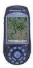
... purchasing a MobileMapper CE from Magellan. Built-in speaker and microphone - It will give you to choose the GIS software that integrates submeter GPS with 320 x 240 resolution and touch screen - Full color, daylight readable, transflective TFT display with Microsoft Windows CE .NET in your Windows CE GPS handheld computer. Embedded Microsoft Windows CE .NET operating system - MobileMapper CE is a handheld...
... purchasing a MobileMapper CE from Magellan. Built-in speaker and microphone - It will give you to choose the GIS software that integrates submeter GPS with 320 x 240 resolution and touch screen - Full color, daylight readable, transflective TFT display with Microsoft Windows CE .NET in your Windows CE GPS handheld computer. Embedded Microsoft Windows CE .NET operating system - MobileMapper CE is a handheld...

Getting Started Guide
Page 8
...-featured Bluetooth connectivity configuration utility - Microsoft File Viewers: Excel, Word and Image Viewers - EZ Recorder - Please contact Magellan to desktop Windows operating systems. MobileMapper CE is a version of the Windows operating system designed for differential corrections - GPS utilities - Bluetooth Manager - Microsoft WordPad, Internet Explorer®, Windows Explorer, Terminal, ActiveSync®, Windows Media Player and...
...-featured Bluetooth connectivity configuration utility - Microsoft File Viewers: Excel, Word and Image Viewers - EZ Recorder - Please contact Magellan to desktop Windows operating systems. MobileMapper CE is a version of the Windows operating system designed for differential corrections - GPS utilities - Bluetooth Manager - Microsoft WordPad, Internet Explorer®, Windows Explorer, Terminal, ActiveSync®, Windows Media Player and...
Getting Started Guide
Page 9
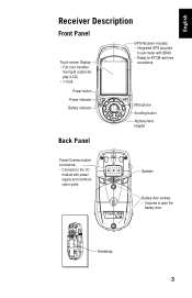
tive liquid crystal display (LCD) • ¼ VGA GPS Receiver includes: • Integrated GPS accurate to sub-meter with SBAS • Ready for RTCM real-time corrections Power button Power indicator Battery indicator Microphone Scrolling button Alphanumeric keypad Back Panel Power/Communication connectors: • Connects to the I/O module with power supply and communication ports Speaker Battery door screws: • Unscrew to open the battery door Handstrap 3 English Receiver Description Front Panel Touch screen Display: • Full color transflec-
tive liquid crystal display (LCD) • ¼ VGA GPS Receiver includes: • Integrated GPS accurate to sub-meter with SBAS • Ready for RTCM real-time corrections Power button Power indicator Battery indicator Microphone Scrolling button Alphanumeric keypad Back Panel Power/Communication connectors: • Connects to the I/O module with power supply and communication ports Speaker Battery door screws: • Unscrew to open the battery door Handstrap 3 English Receiver Description Front Panel Touch screen Display: • Full color transflec-

Getting Started Guide
Page 10
To reset only the GPS receiver, (see GPS Reset on the device by pressing the power button. Mini USB (Type B) port DC Power Input connector Serial port (COM1) DB-9 connector Resetting MobileMapper CE To reset MobileMapper CE, hold down the ESC, Enter and Power keys simultaneously until the screen goes blank. cess the SD card slot I/O Module USB... Connector Secure Digital Card Slot Door: • Open the door to a USB flash drive, card reader etc. You can then power on page 45). 4 The MobileMapper CE switches off.
To reset only the GPS receiver, (see GPS Reset on the device by pressing the power button. Mini USB (Type B) port DC Power Input connector Serial port (COM1) DB-9 connector Resetting MobileMapper CE To reset MobileMapper CE, hold down the ESC, Enter and Power keys simultaneously until the screen goes blank. cess the SD card slot I/O Module USB... Connector Secure Digital Card Slot Door: • Open the door to a USB flash drive, card reader etc. You can then power on page 45). 4 The MobileMapper CE switches off.
Getting Started Guide
Page 13
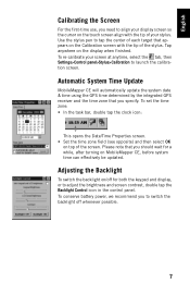
... system time can effectively be updated. Tap anywhere on top of the screen. Automatic System Time Update MobileMapper CE will automatically update the system date & time using the GPS time determined by the integrated GPS receiver and the time zone that you should wait for both the keypad and display, or to adjust the brightness...
... system time can effectively be updated. Tap anywhere on top of the screen. Automatic System Time Update MobileMapper CE will automatically update the system date & time using the GPS time determined by the integrated GPS receiver and the time zone that you should wait for both the keypad and display, or to adjust the brightness...
Getting Started Guide
Page 18
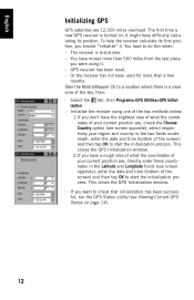
...Select the tab, then Programs>GPS Utilities>GPS Initial- Initialize the receiver using one of the two methods below: 1.If you were using it. - This closes the GPS Initialization window. - Take the MobileMapper CE to a location where there is brand new. - Or the receiver has not been used for more... than a few months. ization - The first time a new GPS receiver is turned on page 14). 12 You have...
...Select the tab, then Programs>GPS Utilities>GPS Initial- Initialize the receiver using one of the two methods below: 1.If you were using it. - This closes the GPS Initialization window. - Take the MobileMapper CE to a location where there is brand new. - Or the receiver has not been used for more... than a few months. ization - The first time a new GPS receiver is turned on page 14). 12 You have...

Getting Started Guide
Page 19
... will be used to be computed when the selected DOP type exceeds the entered Maximum DOP. 13 Select the tab, then Programs>GPS Utilities>GPS Settings to set the following parameters are displayed (see next field). Do not use this option unless you are working in which ...parameters: - DOP type: Choose the DOP type on both the availability and accuracy of Precision) is associated with these parameters. English Setting Up GPS The GPS Settings tool is used . HDOP (Horizontal Dilution of the position computed by the unit. Maximum DOP [PDOP or HDOP]: DOP values considered ...
... will be used to be computed when the selected DOP type exceeds the entered Maximum DOP. 13 Select the tab, then Programs>GPS Utilities>GPS Settings to set the following parameters are displayed (see next field). Do not use this option unless you are working in which ...parameters: - DOP type: Choose the DOP type on both the availability and accuracy of Precision) is associated with these parameters. English Setting Up GPS The GPS Settings tool is used . HDOP (Horizontal Dilution of the position computed by the unit. Maximum DOP [PDOP or HDOP]: DOP values considered ...

Getting Started Guide
Page 20
...mask is not set in fact use preset values for Signal-to log and playback NMEA data. Viewing Current GPS Status The GPS Status utility allows you to quickly see if the GPS receiver is high enough to avoid using satellites near the horizon as they are to right: - Do the ...set too low (less than satellites higher overhead. Tap Apply after making your receiver is calculating the position from the satellite are often noisier than 20). x is configured to launch GPS Status: - By default, the GPS is the current size of degrees above the horizon before the signals from ...
...mask is not set in fact use preset values for Signal-to log and playback NMEA data. Viewing Current GPS Status The GPS Status utility allows you to quickly see if the GPS receiver is high enough to avoid using satellites near the horizon as they are to right: - Do the ...set too low (less than satellites higher overhead. Tap Apply after making your receiver is calculating the position from the satellite are often noisier than 20). x is configured to launch GPS Status: - By default, the GPS is the current size of degrees above the horizon before the signals from ...
Getting Started Guide
Page 21
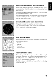
... all the satellites currently in graphical form (see page 16). 15 The signal quality window will grow or shrink to the GPS receiver used and received). Statistics Window (Stats) This window provides the averaged coordinates of Precision (DOP) values are also displayed. Heading - Panel .../Noise ratios for received satellites. The Dilution of the computed position and shows the accuracy figures corresponding to accommodate the number of satellites (used in view. English Signal Quality/Navigation Window (Sig/Nav) This window allows you to the MobileMapper CE unit: - The...
... all the satellites currently in graphical form (see page 16). 15 The signal quality window will grow or shrink to the GPS receiver used and received). Statistics Window (Stats) This window provides the averaged coordinates of Precision (DOP) values are also displayed. Heading - Panel .../Noise ratios for received satellites. The Dilution of the computed position and shows the accuracy figures corresponding to accommodate the number of satellites (used in view. English Signal Quality/Navigation Window (Sig/Nav) This window allows you to the MobileMapper CE unit: - The...
Getting Started Guide
Page 22
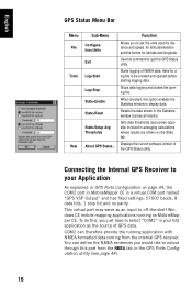
Stops data logging and closes the open log file. When checked, this port from the internal GPS receiver. Connecting the Internal GPS Receiver to your GIS application as an input to display data. You can therefore provide the running on page 44, the COM2 port ... Output" and has fixed settings: 57600 bauds, 8 data bits, 1 stop bit and no parity. Resets the data shown in GPS Ports Configuration on MobileMapper CE. Starts logging of the GPS Status utility. Use this , you to select "COM2" in your Application As explained in the Statistics window (zeroes all results). Asks ...
Stops data logging and closes the open log file. When checked, this port from the internal GPS receiver. Connecting the Internal GPS Receiver to your GIS application as an input to display data. You can therefore provide the running on page 44, the COM2 port ... Output" and has fixed settings: 57600 bauds, 8 data bits, 1 stop bit and no parity. Resets the data shown in GPS Ports Configuration on MobileMapper CE. Starts logging of the GPS Status utility. Use this , you to select "COM2" in your Application As explained in the Statistics window (zeroes all results). Asks ...

Getting Started Guide
Page 34
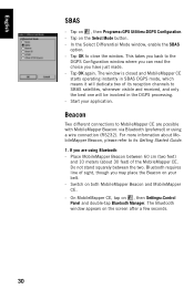
...Beacon: Differential corrections are received by the beltcarried Magellan MobileMapper beacon. They are received by MobileMapper CE itself through one of the... following DGPS modes: 1. Parameter Host IP Address Port Number Direct IP • • NTRIP • • Login • Password • 28 Direct IP: Differential corrections are taken from SBAS satellites (SBAS) are routed to MobileMapper CE... to the MobileMapper CE via Internet Protocol): Same as Direct IP...
...Beacon: Differential corrections are received by the beltcarried Magellan MobileMapper beacon. They are received by MobileMapper CE itself through one of the... following DGPS modes: 1. Parameter Host IP Address Port Number Direct IP • • NTRIP • • Login • Password • 28 Direct IP: Differential corrections are taken from SBAS satellites (SBAS) are routed to MobileMapper CE... to the MobileMapper CE via Internet Protocol): Same as Direct IP...

Getting Started Guide
Page 35
...Age Limit parameter. Once a DGPS mode is used, any accidental disruption in the continuation of this warning message appears, MobileMapper CE will automatically switch to Autonomous GPS mode. 29 When this chapter. Step # DGPS Mode Step 1 SBAS Select SBAS mode Beacon via COM1 Connect Serial Data... or GPRS. English The table below lists the different steps you will trigger a warning message of the type "No differential corrections received over xx sec! Correction age limit = xx sec". Bluetooth tooth Connection Beacon via Connect Serial COM1 Data Cable Direct IP Establish ...
...Age Limit parameter. Once a DGPS mode is used, any accidental disruption in the continuation of this warning message appears, MobileMapper CE will automatically switch to Autonomous GPS mode. 29 When this chapter. Step # DGPS Mode Step 1 SBAS Select SBAS mode Beacon via COM1 Connect Serial Data... or GPRS. English The table below lists the different steps you will trigger a warning message of the type "No differential corrections received over xx sec! Correction age limit = xx sec". Bluetooth tooth Connection Beacon via Connect Serial COM1 Data Cable Direct IP Establish ...
Getting Started Guide
Page 36
...Getting Started Guide. 1. The Bluetooth window appears on , then Programs>GPS Utilities>DGPS Configuration. - Tap OK to MobileMapper CE are using a wire connection (RS232). This takes you back to SBAS satellites, whenever visible and received, and only the best one will be involved in SBAS DGPS mode,... which means it will dedicate two of sight, though you may place the Beacon on both MobileMapper Beacon and MobileMapper CE. - The window is closed and MobileMapper CE starts operating instantly in...
...Getting Started Guide. 1. The Bluetooth window appears on , then Programs>GPS Utilities>DGPS Configuration. - Tap OK to MobileMapper CE are using a wire connection (RS232). This takes you back to SBAS satellites, whenever visible and received, and only the best one will be involved in SBAS DGPS mode,... which means it will dedicate two of sight, though you may place the Beacon on both MobileMapper Beacon and MobileMapper CE. - The window is closed and MobileMapper CE starts operating instantly in...

Getting Started Guide
Page 38
... button. - In the Port field, on , then Programs>GPS Utilities>DGPS Configuration. - Tap on the Tune button. - But when selecting Beacon as the DGPS data source: - Typically, you need to tune the MobileMapper Beacon receiver: • Tune Automatically (automatic method; default choice). •...; Tune by Frequency (manual method: you have changed the virtual port in fact forced to receive) (see screen example opposite). - Tap OK. ...
... button. - In the Port field, on , then Programs>GPS Utilities>DGPS Configuration. - Tap on the Tune button. - But when selecting Beacon as the DGPS data source: - Typically, you need to tune the MobileMapper Beacon receiver: • Tune Automatically (automatic method; default choice). •...; Tune by Frequency (manual method: you have changed the virtual port in fact forced to receive) (see screen example opposite). - Tap OK. ...
Getting Started Guide
Page 39
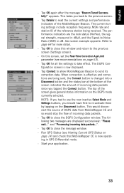
...the Signal-to take effect. The following two messages are being received. Start your application. 33 English - appears. Tap Connect to allow MobileMapper Beacon to re-activate them by tapping on page 14) and check that MobileMapper CE is changed into a Disconnect button and the status bar at ... wait..." This would disconnect the source of DGPS data from MobileMapper CE and so would stop the flow of the reference station being sent, the Connect button is now operating in GPS Differential mode. - The top of the MobileMapper Beacon. Tap OK to close the message window. - Tap...
...the Signal-to take effect. The following two messages are being received. Start your application. 33 English - appears. Tap Connect to allow MobileMapper Beacon to re-activate them by tapping on page 14) and check that MobileMapper CE is changed into a Disconnect button and the status bar at ... wait..." This would disconnect the source of DGPS data from MobileMapper CE and so would stop the flow of the reference station being sent, the Connect button is now operating in GPS Differential mode. - The top of the MobileMapper Beacon. Tap OK to close the message window. - Tap...


