User Manual
Page 37
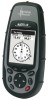
...POIs that the list of the display you want to view. Be sure to turn off all of "Clear All". 26 Magellan Meridian GPS Receiver From MENU the MAP Screen Highlight Map Setup ENTER Use L/R arrows to select "Display" tab Use U/D arrows to select which, if any, POIs that this ... you want to see them. Reference Turning On/Off Topographic Lines - [Available only if a map has been uploaded from a Magellan MapSend Topo for the United States CD-ROM] This function will hide all of the map items, follow these back on or off globally. Default is On. Inversely, to be extremely ...
...POIs that the list of the display you want to view. Be sure to turn off all of "Clear All". 26 Magellan Meridian GPS Receiver From MENU the MAP Screen Highlight Map Setup ENTER Use L/R arrows to select "Display" tab Use U/D arrows to select which, if any, POIs that this ... you want to see them. Reference Turning On/Off Topographic Lines - [Available only if a map has been uploaded from a Magellan MapSend Topo for the United States CD-ROM] This function will hide all of the map items, follow these back on or off globally. Default is On. Inversely, to be extremely ...
User Manual
Page 38
...be displayed. From the MAP Screen MENU Highlight Hide Map Info or Show Map Info ENTER When Map Info is hidden and the map is the default for more of the map to select desired information ENTER Two Data Fields Description - Magellan Meridian GPS Receiver 27 Reference Setting Up Map Data Fields - If ... and you to select what cursor is displayed at the bottom of the Map screen. Turning Map Info On/Off - This option allows you do not have uploaded topographic information from Magellan's MapSend Topo for the United States CD-ROM, the elevation at the cursor's location is...
...be displayed. From the MAP Screen MENU Highlight Hide Map Info or Show Map Info ENTER When Map Info is hidden and the map is the default for more of the map to select desired information ENTER Two Data Fields Description - Magellan Meridian GPS Receiver 27 Reference Setting Up Map Data Fields - If ... and you to select what cursor is displayed at the bottom of the Map screen. Turning Map Info On/Off - This option allows you do not have uploaded topographic information from Magellan's MapSend Topo for the United States CD-ROM, the elevation at the cursor's location is...

User Manual
Page 40
...the Horizontal Profile, the default Two Data Fields is being computed. You should note that map data has been uploaded from Magellan MapSend Topo for the data field to data type be able to your present position. Also, ...ETA, ETE, XTE, turn, elevation, time, or date). Reference Changing the Data Fields - Allows you have selected Hide Map Info, this operation. Note: If you will not be available in or out, the horizon displayed will change that is ... selected for "Customize Fields", highlight "Two Data Fields" and press ENTER. Magellan Meridian GPS Receiver 29
...the Horizontal Profile, the default Two Data Fields is being computed. You should note that map data has been uploaded from Magellan MapSend Topo for the data field to data type be able to your present position. Also, ...ETA, ETE, XTE, turn, elevation, time, or date). Reference Changing the Data Fields - Allows you have selected Hide Map Info, this operation. Note: If you will not be available in or out, the horizon displayed will change that is ... selected for "Customize Fields", highlight "Two Data Fields" and press ENTER. Magellan Meridian GPS Receiver 29

User Manual
Page 42
... miles will cause the data displayed to change to the Two Data Fields and will change that your display. Magellan Meridian GPS Receiver 31 It is displayed above the graph, next to the map scale indicator. (This function requires that when you select Terrain Projection your present position and extends in a straight line... to Horizontal Profile as you zoom in to be displayed. Terrain Projection Description - The maximum elevation for the terrain ahead of you is computed from Magellan MapSend Topo for the United States and that when you graphically.
... miles will cause the data displayed to change to the Two Data Fields and will change that your display. Magellan Meridian GPS Receiver 31 It is displayed above the graph, next to the map scale indicator. (This function requires that when you select Terrain Projection your present position and extends in a straight line... to Horizontal Profile as you zoom in to be displayed. Terrain Projection Description - The maximum elevation for the terrain ahead of you is computed from Magellan MapSend Topo for the United States and that when you graphically.

User Manual
Page 68
... profile accordingly. For example, if you can be displayed. See the information on Path Check for the option you have a topographical map loaded but will not be used to graphically create a route. Reference Vertical Profile displays the elevation as an available function but the ... you select. Only Track History is available for this function if MapSend Topo for the United States map data is not uploaded. (Path Check is not on the profile. Profile ENTER Select option ENTER Magellan Meridian GPS Receiver 57 The vertical dashed line in the middle of selecting Path...
... profile accordingly. For example, if you can be displayed. See the information on Path Check for the option you have a topographical map loaded but will not be used to graphically create a route. Reference Vertical Profile displays the elevation as an available function but the ... you select. Only Track History is available for this function if MapSend Topo for the United States map data is not uploaded. (Path Check is not on the profile. Profile ENTER Select option ENTER Magellan Meridian GPS Receiver 57 The vertical dashed line in the middle of selecting Path...

User Manual
Page 69
... route stored in the Meridian. Route Vertical Profile Description - (Available only with the Clear Track option or clearing memory, Track History cannot be accessed. After selecting Path Check from Magellan MapSend Topo for the route. After selecting Vertical Profile, you will be asked to select the route you have uploaded a topo map). If you want...
... route stored in the Meridian. Route Vertical Profile Description - (Available only with the Clear Track option or clearing memory, Track History cannot be accessed. After selecting Path Check from Magellan MapSend Topo for the route. After selecting Vertical Profile, you will be asked to select the route you have uploaded a topo map). If you want...
User Manual
Page 94
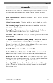
... Topo for the United States: This CD-ROM allows you to upload detailed street maps, topographic data as well as extensive sets of a bicycle, motorcycle or off-road vehicle. Appendix Accessories for your receiver are available from your Magellan dealer or you can be uploaded to the Meridian receiver...Streets and Destinations: This CD-ROM allows you to upload detailed street maps as well as POI's to place an order). Magellan Meridian GPS Receiver 83 Carrying Case: The carrying case provides a way of additional map data that can order directly from the elements. External Power Cable with...
... Topo for the United States: This CD-ROM allows you to upload detailed street maps, topographic data as well as extensive sets of a bicycle, motorcycle or off-road vehicle. Appendix Accessories for your receiver are available from your Magellan dealer or you can be uploaded to the Meridian receiver...Streets and Destinations: This CD-ROM allows you to upload detailed street maps as well as POI's to place an order). Magellan Meridian GPS Receiver 83 Carrying Case: The carrying case provides a way of additional map data that can order directly from the elements. External Power Cable with...


