User Manual
Page 3
... The Global Positioning System (GPS) is an excellent navigation aid, but does not replace the need for use , copy, modify, reverse engineer or transfer this SOFTWARE except as expressly provided in the normal operation of the equipment. Accuracy can be reproduced or transmitted in any settings on one device for navigating. USE PROPER ACCESSORIES Use only Magellan cables and antennas; The SOFTWARE is subject to GPS satellites made by...
... The Global Positioning System (GPS) is an excellent navigation aid, but does not replace the need for use , copy, modify, reverse engineer or transfer this SOFTWARE except as expressly provided in the normal operation of the equipment. Accuracy can be reproduced or transmitted in any settings on one device for navigating. USE PROPER ACCESSORIES Use only Magellan cables and antennas; The SOFTWARE is subject to GPS satellites made by...
User Manual
Page 8
Position Screen 36 GPS Status Messages 37 Selecting the Position Screen 37 Resetting the Trip Odometer 38 Customizing the Data Fields 38 Selecting Coordinate System, Map Datum and Elevation Mode 38 Road Screen 39 Customizing the Data Fields 39 Data Screen 40 Customizing the Data Fields 40 Speed Screen 41 Customizing the Data Fields 41 Satellite Status Screen 42 Waypoints / Database 43 Accessing Waypoints in the Database 43 Selecting User Waypoints (Alphabetic 45 Selecting Preloaded Waypoints (Alphabetic 45 Selecting Uploaded Waypoints (Alphabetic 45 Selecting User Waypoints (...
Position Screen 36 GPS Status Messages 37 Selecting the Position Screen 37 Resetting the Trip Odometer 38 Customizing the Data Fields 38 Selecting Coordinate System, Map Datum and Elevation Mode 38 Road Screen 39 Customizing the Data Fields 39 Data Screen 40 Customizing the Data Fields 40 Speed Screen 41 Customizing the Data Fields 41 Satellite Status Screen 42 Waypoints / Database 43 Accessing Waypoints in the Database 43 Selecting User Waypoints (Alphabetic 45 Selecting Preloaded Waypoints (Alphabetic 45 Selecting Uploaded Waypoints (Alphabetic 45 Selecting User Waypoints (...
User Manual
Page 9
...Map Screen 56 Creating a Route using Track History 56 Using Vertical Profile 57 Selecting Vertical Profile 57 Track History Description 58 Highlighted Road Vertical Profile Description 58 Route Vertical Profile Description 58 Path Check Description 58 Setup ...59 Initializing the Meridian 59 Turning the NAV Screens On/Off 59 Selecting the Coordinate System 60 Selecting a Map Datum 60 Selecting the Elevation Mode 61 Selecting the Time Format 61 Selecting NAV Units 61 Selecting the North Reference 62 Selecting Daylight Savings 62 Power Off Timer 63 Setting the Backlight Timer...
...Map Screen 56 Creating a Route using Track History 56 Using Vertical Profile 57 Selecting Vertical Profile 57 Track History Description 58 Highlighted Road Vertical Profile Description 58 Route Vertical Profile Description 58 Path Check Description 58 Setup ...59 Initializing the Meridian 59 Turning the NAV Screens On/Off 59 Selecting the Coordinate System 60 Selecting a Map Datum 60 Selecting the Elevation Mode 61 Selecting the Time Format 61 Selecting NAV Units 61 Selecting the North Reference 62 Selecting Daylight Savings 62 Power Off Timer 63 Setting the Backlight Timer...
User Manual
Page 10
Changing the Power Key Settings 65 Selecting Languages 65 Clearing Memory 66 Clearing Track History 66 Clearing Wpts/Routes 66 Clearing All Routes 66 Resetting Meridian to Memory Card 71 Save Track ...71 Loading Waypoints and Routes from Memory Card 71 Loading Track from Memory Card 72 Deleting Files from Memory Card 72 Testing the Memory Card 72 Changing the Detailed Map 73 Formating the Memory Card 73 Magellan Meridian GPS Receiver v User Mode 70 Turning the Simulator Off 70 Using the Card Utilities 71 Save Waypoints and Routes to Factory Defaults 66 Clearing All Memory ...
Changing the Power Key Settings 65 Selecting Languages 65 Clearing Memory 66 Clearing Track History 66 Clearing Wpts/Routes 66 Clearing All Routes 66 Resetting Meridian to Memory Card 71 Save Track ...71 Loading Waypoints and Routes from Memory Card 71 Loading Track from Memory Card 72 Deleting Files from Memory Card 72 Testing the Memory Card 72 Changing the Detailed Map 73 Formating the Memory Card 73 Magellan Meridian GPS Receiver v User Mode 70 Turning the Simulator Off 70 Using the Card Utilities 71 Save Waypoints and Routes to Factory Defaults 66 Clearing All Memory ...
User Manual
Page 11
About Screen 73 Help Screen 73 Frequently Asked Questions General 74 Waypoints/Database 75 Navigation Screens 76 Routes 76 Alarms 77 Output Data 77 Appendix Troubleshooting 78 Waypoint Icons 79 Contacting Magellan 80 Updating Your Meridian 81 Specifications 82 Accessories 83 MapSend® Streets 84 Using MapSend 85 Installing Memory Card 88 Connecting to External Devices 89 WAAS 91 Glossary 92 vi Magellan Meridian GPS Receiver
About Screen 73 Help Screen 73 Frequently Asked Questions General 74 Waypoints/Database 75 Navigation Screens 76 Routes 76 Alarms 77 Output Data 77 Appendix Troubleshooting 78 Waypoint Icons 79 Contacting Magellan 80 Updating Your Meridian 81 Specifications 82 Accessories 83 MapSend® Streets 84 Using MapSend 85 Installing Memory Card 88 Connecting to External Devices 89 WAAS 91 Glossary 92 vi Magellan Meridian GPS Receiver
User Manual
Page 13
... familiar to external devices, accessories, troubleshooting and specifications can quickly and easily find many of the manual as we have any new information in the Meridian and this chapter but new GPS users may have about connecting your Meridian, the global positioning system (GPS) and using your Meridian and the accompanying documentation. Glossary: A glossary is set up in a way that you can be overwhelmed with the size of their...
... familiar to external devices, accessories, troubleshooting and specifications can quickly and easily find many of the manual as we have any new information in the Meridian and this chapter but new GPS users may have about connecting your Meridian, the global positioning system (GPS) and using your Meridian and the accompanying documentation. Glossary: A glossary is set up in a way that you can be overwhelmed with the size of their...
User Manual
Page 15
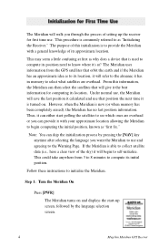
... collect satellite data (i.e., have a clear view of this information, the Meridian can skip the initialization process by the language selection screen. 4 Magellan Meridian GPS Receiver Step 1: Turn the Meridian On Press [PWR] The Meridian turns on . This procedure is turned on and displays the start polling the satellites to see which ones are overhead or you can provide it has in memory to select what satellites are overhead. Under normal use, the Meridian will save the last position...
... collect satellite data (i.e., have a clear view of this information, the Meridian can skip the initialization process by the language selection screen. 4 Magellan Meridian GPS Receiver Step 1: Turn the Meridian On Press [PWR] The Meridian turns on . This procedure is turned on and displays the start polling the satellites to see which ones are overhead or you can provide it has in memory to select what satellites are overhead. Under normal use, the Meridian will save the last position...
User Manual
Page 19
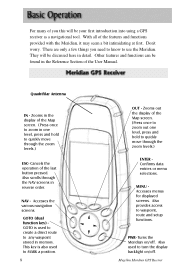
... waypoint stored in one level, press and hold to turn the display backlight on /off . Magellan Meridian GPS Receiver MENU Accesses menus for displayed screens. There are only a few things you this will be your first introduction into using a GPS receiver as a navigational tool. Also scrolls through the NAV screens in the display of the last button pressed. This key is used to create a direct route to quickly move through the zoom levels.) ENTER Confirms data entries or menu selections...
... waypoint stored in one level, press and hold to turn the display backlight on /off . Magellan Meridian GPS Receiver MENU Accesses menus for displayed screens. There are only a few things you this will be your first introduction into using a GPS receiver as a navigational tool. Also scrolls through the NAV screens in the display of the last button pressed. This key is used to create a direct route to quickly move through the zoom levels.) ENTER Confirms data entries or menu selections...
User Manual
Page 23
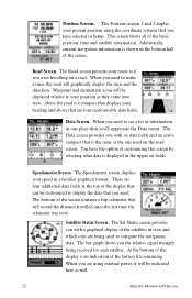
... speed in the bottom half of the screen. This screen shows all of the battery life remaining. Above the road is shown in a familiar graphical format. The Speedometer screen displays your position as well. 12 Magellan Meridian GPS Receiver Waypoint and destination icons will record the distance travelled since the last time the odometer was reset. Speedometer Screen. Additionally, current navigation information is a compass that displays your route as if you have the option of the screen contains a trip odometer...
... speed in the bottom half of the screen. This screen shows all of the battery life remaining. Above the road is shown in a familiar graphical format. The Speedometer screen displays your position as well. 12 Magellan Meridian GPS Receiver Waypoint and destination icons will record the distance travelled since the last time the odometer was reset. Speedometer Screen. Additionally, current navigation information is a compass that displays your route as if you have the option of the screen contains a trip odometer...
User Manual
Page 25
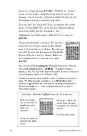
... the Mark screen. The very top of the User Manual. Backspace - Use the UP/DOWN arrows and notice that reason, you are entering and displayed in the Reference Chapter of the keyboard window shows you what field you want to change the default name to one space, erasing the last character entered. When you have highlighted the icon you are listed in the field above the keys. (Note: waypoint...
... the Mark screen. The very top of the User Manual. Backspace - Use the UP/DOWN arrows and notice that reason, you are entering and displayed in the Reference Chapter of the keyboard window shows you what field you want to change the default name to one space, erasing the last character entered. When you have highlighted the icon you are listed in the field above the keys. (Note: waypoint...
User Manual
Page 28
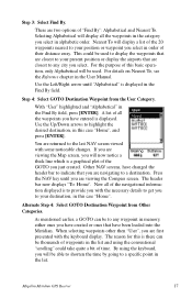
... Compass screen. Other NAV screens, have changed the header bar to indicate that are closest to highlight the desired destination, in this is displayed in memory, either ones you have been loaded into the Meridian. Now all the waypoints you have created or ones that have entered is a graphical plot of time. When selecting waypoints other then "User", you are viewing the Map screen, you just created. By using...
... Compass screen. Other NAV screens, have changed the header bar to indicate that are closest to highlight the desired destination, in this is displayed in memory, either ones you have been loaded into the Meridian. Now all the waypoints you have created or ones that have entered is a graphical plot of time. When selecting waypoints other then "User", you are viewing the Map screen, you just created. By using...
User Manual
Page 37
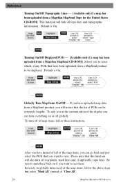
... select "Mark All" instead of "Clear All". 26 Magellan Meridian GPS Receiver Default is On. Default is On. From MENU the MAP Screen Highlight Map Setup ENTER Use L/R arrows to select "Display" tab Use U/D arrows to select "Topo Lines" ENTER Turning On/Off Displayed POI's - [Available only if a map has been uploaded from a Magellan MapSend CD-ROM] Allows you to select which, if any, POIs that the list of POIs can be displayed. If you have uploaded map data...
... select "Mark All" instead of "Clear All". 26 Magellan Meridian GPS Receiver Default is On. Default is On. From MENU the MAP Screen Highlight Map Setup ENTER Use L/R arrows to select "Display" tab Use U/D arrows to select "Topo Lines" ENTER Turning On/Off Displayed POI's - [Available only if a map has been uploaded from a Magellan MapSend CD-ROM] Allows you to select which, if any, POIs that the list of POIs can be displayed. If you have uploaded map data...
User Manual
Page 38
... the United States CD-ROM, the elevation at the bottom of the object is displayed. Reference Setting Up Map Data Fields - From the MAP Screen MENU Highlight Hide Map Info or Show Map Info ENTER When Map Info is hidden and the map is displayed. Note: If you select either Horizontal Profile or Terrain Projection and you have topographic information loaded a warning screen is in the bottom left corner of the Map screen. Magellan Meridian GPS Receiver 27...
... the United States CD-ROM, the elevation at the bottom of the object is displayed. Reference Setting Up Map Data Fields - From the MAP Screen MENU Highlight Hide Map Info or Show Map Info ENTER When Map Info is hidden and the map is displayed. Note: If you select either Horizontal Profile or Terrain Projection and you have topographic information loaded a warning screen is in the bottom left corner of the Map screen. Magellan Meridian GPS Receiver 27...
User Manual
Page 44
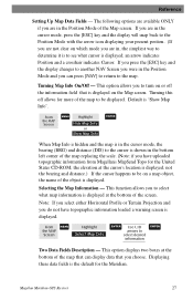
... base rate of track points saved increased. The following is highly recommended that you turn, the Meridian increases the rate of track points. Auto vs. Reference From MENU the MAP Screen Highlight Map Setup ENTER Use arrows to ENTER highlight the "Track Mode" field Use arrows to ENTER NAV select Mode Setting the Track Mode to "OFF" will notice two of the options for a good representation of your Meridian to create a backtrack route. The same temporary waypoints used to the ability of the three track rate...
... base rate of track points saved increased. The following is highly recommended that you turn, the Meridian increases the rate of track points. Auto vs. Reference From MENU the MAP Screen Highlight Map Setup ENTER Use arrows to ENTER highlight the "Track Mode" field Use arrows to ENTER NAV select Mode Setting the Track Mode to "OFF" will notice two of the options for a good representation of your Meridian to create a backtrack route. The same temporary waypoints used to the ability of the three track rate...
User Manual
Page 60
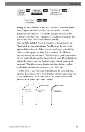
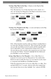
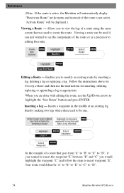
... Any Screen MENU Highlight Database ENTER Highlight User ENTER Select ENTER Use U/D arrows ENTER Waypoint to use the View button. Note: This function is in a route after selecting it may be stored in a route. Locates and displays on the Map - Also note that any field of the waypoint that it is for Viewing a Map Object on the Map - You would do this feature using User waypoints. Edit any edits you have selected. Follow the instructions above for viewing map objects (cities, airports, etc.) only. Magellan Meridian GPS Receiver...
... Any Screen MENU Highlight Database ENTER Highlight User ENTER Select ENTER Use U/D arrows ENTER Waypoint to use the View button. Note: This function is in a route after selecting it may be stored in a route. Locates and displays on the Map - Also note that any field of the waypoint that it is for Viewing a Map Object on the Map - You would do this feature using User waypoints. Edit any edits you have selected. Follow the instructions above for viewing map objects (cities, airports, etc.) only. Magellan Meridian GPS Receiver...
User Manual
Page 62
... Backtrk ENTER Magellan Meridian GPS Receiver 51 You need do is gone. Also note that you there. You can select only those waypoints in your Meridian off and then back on completing the route. After 30 minutes you turn your general vicinity (Nearest) or all of using track information stored in memory. When you choose to return to clear it. Creating a Backtrack Route - From Any Screen MENU Highlight Routes ENTER Select ENTER "Backtrack...
... Backtrk ENTER Magellan Meridian GPS Receiver 51 You need do is gone. Also note that you there. You can select only those waypoints in your Meridian off and then back on completing the route. After 30 minutes you turn your general vicinity (Nearest) or all of using track information stored in memory. When you choose to return to clear it. Creating a Backtrack Route - From Any Screen MENU Highlight Routes ENTER Select ENTER "Backtrack...
User Manual
Page 65
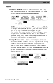
... "D". 54 Magellan Meridian GPS Receiver Highlight destination MENU See Instructions for waypoint for Viewing a Route and then use the Up/Down arrows to modify an existing route by inserting a leg, deleting a leg or replacing a leg. Inserting a Leg - From Any Screen MENU Highlight Routes ENTER Select Route MENU Highlight ENTER View/Edit Route Editing a Route - When you to highlight the "Save Route" button and press ENTER. Your route would highlight the waypoint "C" and follow the steps to create the route. Viewing a route can be used to insert waypoint "E". Follow...
... "D". 54 Magellan Meridian GPS Receiver Highlight destination MENU See Instructions for waypoint for Viewing a Route and then use the Up/Down arrows to modify an existing route by inserting a leg, deleting a leg or replacing a leg. Inserting a Leg - From Any Screen MENU Highlight Routes ENTER Select Route MENU Highlight ENTER View/Edit Route Editing a Route - When you to highlight the "Save Route" button and press ENTER. Your route would highlight the waypoint "C" and follow the steps to create the route. Viewing a route can be used to insert waypoint "E". Follow...
User Manual
Page 74
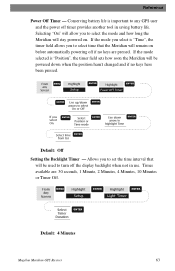
... Backlight Timer - Allows you to select time that will remain on . If the mode you select is important to any Screen MENU Highlight Setup ENTER Highlight Power Off Timer ENTER ENTER Use up/down arrows to select On or Off ENTER If you to set the time interval that the Meridian will be powered down ENTER arrow to turn off timer provides another tool in use. From Any Screen MENU Highlight Setup ENTER Highlight Light Timer ENTER Select Timer Duration ENTER Default: 4 Minutes Magellan Meridian GPS Receiver 63 Times available are pressed. Reference Power...
... Backlight Timer - Allows you to select time that will remain on . If the mode you select is important to any Screen MENU Highlight Setup ENTER Highlight Power Off Timer ENTER ENTER Use up/down arrows to select On or Off ENTER If you to set the time interval that the Meridian will be powered down ENTER arrow to turn off timer provides another tool in use. From Any Screen MENU Highlight Setup ENTER Highlight Light Timer ENTER Select Timer Duration ENTER Default: 4 Minutes Magellan Meridian GPS Receiver 63 Times available are pressed. Reference Power...
User Manual
Page 89
... are using . Receiver turns off when not needed. Use map data for instructions on your LAT/LON format. Replace with the Meridian turned on. 78 Magellan Meridian GPS Receiver Make sure that the antenna is pointing up to the map. Data was not saved or was corrupted. The map datum is caused by distance shifts to use of the batteries can be caused by excessive static electicity. Move the receiver to a new location to a new location. 2. Position on map is a reasonable distance...
... are using . Receiver turns off when not needed. Use map data for instructions on your LAT/LON format. Replace with the Meridian turned on. 78 Magellan Meridian GPS Receiver Make sure that the antenna is pointing up to the map. Data was not saved or was corrupted. The map datum is caused by distance shifts to use of the batteries can be caused by excessive static electicity. Move the receiver to a new location to a new location. 2. Position on map is a reasonable distance...
User Manual
Page 103
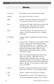
... datum for the map you are unsure of a route currently being traveled. Distance. Magellan Meridian GPS Receiver Bearing. Refers to the theoretical mathematical model of the current. Distance from one datum to another. The estimated time of the map. Course to destination. The value or setting automatically chosen by the unit unless otherwise directed. Can be found in marine charts) that projects from your position and the current leg destination waypoint. The compass direction from your current position to a point...
... datum for the map you are unsure of a route currently being traveled. Distance. Magellan Meridian GPS Receiver Bearing. Refers to the theoretical mathematical model of the current. Distance from one datum to another. The estimated time of the map. Course to destination. The value or setting automatically chosen by the unit unless otherwise directed. Can be found in marine charts) that projects from your position and the current leg destination waypoint. The compass direction from your current position to a point...


