User Manual
Page 3
... rights not expressly granted are registered trademarks of Thales Navigation. Meridian is operated by the periodic adjustments to change any purpose other copyright material. Government and is subject to GPS satellites made by Thales Navigation. You may not use without ..., the purchaser, the right to a complete stop or have your organization. Magellan and MapSend are reserved by United States copyright laws and international treaty provisions; USE PROPER ACCESSORIES Use only Magellan cables and antennas; Revision B You may make any other than the purchaser's...
... rights not expressly granted are registered trademarks of Thales Navigation. Meridian is operated by the periodic adjustments to change any purpose other copyright material. Government and is subject to GPS satellites made by Thales Navigation. You may not use without ..., the purchaser, the right to a complete stop or have your organization. Magellan and MapSend are reserved by United States copyright laws and international treaty provisions; USE PROPER ACCESSORIES Use only Magellan cables and antennas; Revision B You may make any other than the purchaser's...
User Manual
Page 4
... printed on implied warranty or how long an 2. ANY REPAIRS BY A (2) batteries; THALES NAVIGATION MAGELLAN PRODUCTS LIMITED WARRANTY All Thales Navigation global positioning system 3.PURCHASER'SDUTIES (GPS) receivers are navigation aids, and are excluded from the warranty OPTION, OF ANY DEFECTIVE PART OF ... FITNESS FOR ANY PARTICULAR PURPOSE OR MERCHANTABILITY, ARE HEREBY DISCLAIMED AND IF APPLICABLE, IMPLIED WARRANTIES UNDER ARTICLE 35 OF THE UNITED NATIONS CONVENTION ON CONTRACTS FOR THE INTERNATIONAL SALE OF GOODS. The repaired or replaced product product incurred while the product is...
... printed on implied warranty or how long an 2. ANY REPAIRS BY A (2) batteries; THALES NAVIGATION MAGELLAN PRODUCTS LIMITED WARRANTY All Thales Navigation global positioning system 3.PURCHASER'SDUTIES (GPS) receivers are navigation aids, and are excluded from the warranty OPTION, OF ANY DEFECTIVE PART OF ... FITNESS FOR ANY PARTICULAR PURPOSE OR MERCHANTABILITY, ARE HEREBY DISCLAIMED AND IF APPLICABLE, IMPLIED WARRANTIES UNDER ARTICLE 35 OF THE UNITED NATIONS CONVENTION ON CONTRACTS FOR THE INTERNATIONAL SALE OF GOODS. The repaired or replaced product product incurred while the product is...
User Manual
Page 9
...History Description 58 Highlighted Road Vertical Profile Description 58 Route Vertical Profile Description 58 Path Check Description 58 Setup ...59 Initializing the Meridian 59 Turning the NAV Screens On/Off 59 Selecting the Coordinate System 60 Selecting a Map Datum 60 Selecting the Elevation Mode... Selecting the Time Format 61 Selecting NAV Units 61 Selecting the North Reference 62 Selecting Daylight Savings 62 Power Off Timer 63 Setting the Backlight Timer 63 Turning the Beeper On/Off 64 Selecting NMEA Message 64 Selecting the Baud Rate 64 iv Magellan Meridian GPS Receiver
...History Description 58 Highlighted Road Vertical Profile Description 58 Route Vertical Profile Description 58 Path Check Description 58 Setup ...59 Initializing the Meridian 59 Turning the NAV Screens On/Off 59 Selecting the Coordinate System 60 Selecting a Map Datum 60 Selecting the Elevation Mode... Selecting the Time Format 61 Selecting NAV Units 61 Selecting the North Reference 62 Selecting Daylight Savings 62 Power Off Timer 63 Setting the Backlight Timer 63 Turning the Beeper On/Off 64 Selecting NMEA Message 64 Selecting the Baud Rate 64 iv Magellan Meridian GPS Receiver
User Manual
Page 18
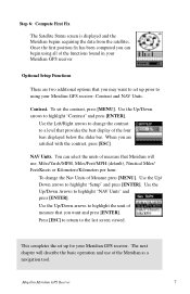
...describe the basic operation and use of measure that Meridian will use; To set up for your Meridian GPS receiver: Contrast and NAV Units. Use the Left/Right arrows to change the Nav Units of the functions found in your Meridian GPS receiver Optional Setup Functions There are satisfied with ... the units of the four bars displayed below the slider bar. Use the Up/Down arrows to highlight "Setup" and press [ENTER]. To change the contrast to set the contrast, press [MENU]. Use the Up/ Down arrows to highlight "Contrast" and press [ENTER]. Magellan Meridian GPS Receiver ...
...describe the basic operation and use of measure that Meridian will use; To set up for your Meridian GPS receiver: Contrast and NAV Units. Use the Left/Right arrows to change the Nav Units of the functions found in your Meridian GPS receiver Optional Setup Functions There are satisfied with ... the units of the four bars displayed below the slider bar. Use the Up/Down arrows to highlight "Setup" and press [ENTER]. To change the contrast to set the contrast, press [MENU]. Use the Up/ Down arrows to highlight "Contrast" and press [ENTER]. Magellan Meridian GPS Receiver ...
User Manual
Page 37
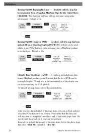
... "Display" tab Use U/D arrows to select "Topo Lines" ENTER Turning On/Off Displayed POI's - [Available only if a map has been uploaded from a Magellan MapSend CD-ROM] Allows you to select Clear All ENTER After you can turn off all of the map items, you have turned off all... - [Available only if a map has been uploaded from a Magellan MapSend Topo for the United States CD-ROM] This function will hide all map items, follow the above steps but select "Mark All" instead of "Clear All". 26 Magellan Meridian GPS Receiver From MENU the MAP Screen Highlight Map Setup ENTER Use L/R...
... "Display" tab Use U/D arrows to select "Topo Lines" ENTER Turning On/Off Displayed POI's - [Available only if a map has been uploaded from a Magellan MapSend CD-ROM] Allows you to select Clear All ENTER After you can turn off all of the map items, you have turned off all... - [Available only if a map has been uploaded from a Magellan MapSend Topo for the United States CD-ROM] This function will hide all map items, follow the above steps but select "Mark All" instead of "Clear All". 26 Magellan Meridian GPS Receiver From MENU the MAP Screen Highlight Map Setup ENTER Use L/R...
User Manual
Page 38
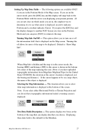
...clear on a map object, the name of the object is displayed at the bottom of the Map screen. Default is the default for the Meridian. Magellan Meridian GPS Receiver 27 an arrow indicates Position and a crosshair indicates Cursor. From the MAP Screen MENU Highlight Hide Map Info or Show Map Info ENTER...of the map replacing the scale. (Note: if you have topographic information loaded a warning screen is displayed on or off allows for the United States CD-ROM, the elevation at the bottom of the map to see what map information is displayed. This function allows you to the ...
...clear on a map object, the name of the object is displayed at the bottom of the Map screen. Default is the default for the Meridian. Magellan Meridian GPS Receiver 27 an arrow indicates Position and a crosshair indicates Cursor. From the MAP Screen MENU Highlight Hide Map Info or Show Map Info ENTER...of the map replacing the scale. (Note: if you have topographic information loaded a warning screen is displayed on or off allows for the United States CD-ROM, the elevation at the bottom of the map to see what map information is displayed. This function allows you to the ...

User Manual
Page 40
...the area uploaded.) This mode displays at the bottom of the Map screen a graphical representation of the horizon at a fixed distance from Magellan MapSend Topo for the United States and that is equal to 1 of 13 different data options (bearing, distance, speed, heading, VMG, CTS, ETA, ETE, ...Orientation to your present position. Horizontal Profile Description - (This function requires that map data has been uploaded from your present position. Magellan Meridian GPS Receiver 29 This mode just displays the name of the two lines indicates the location on the Map screen to be available in...
...the area uploaded.) This mode displays at the bottom of the Map screen a graphical representation of the horizon at a fixed distance from Magellan MapSend Topo for the United States and that is equal to 1 of 13 different data options (bearing, distance, speed, heading, VMG, CTS, ETA, ETE, ...Orientation to your present position. Horizontal Profile Description - (This function requires that map data has been uploaded from your present position. Magellan Meridian GPS Receiver 29 This mode just displays the name of the two lines indicates the location on the Map screen to be available in...

User Manual
Page 41
... shortest distance to your destination from your present position to the course line you are getting closer to your destination. Time Local time. Nav Units. This is the angle that you are off course, your VMG will be less than the speed that it will be on a direct ...as Speed since all of Arrival). XTE is the direction you need to turn to put you to your destination. Date Current date. 30 Magellan Meridian GPS Receiver Turn This is the perpendicular distance from your destination. Distance This is the rate that you are travelling on to go to your ...
... shortest distance to your destination from your present position to the course line you are getting closer to your destination. Time Local time. Nav Units. This is the angle that you are off course, your VMG will be less than the speed that it will be on a direct ...as Speed since all of Arrival). XTE is the direction you need to turn to put you to your destination. Date Current date. 30 Magellan Meridian GPS Receiver Turn This is the perpendicular distance from your destination. Distance This is the rate that you are travelling on to go to your ...

User Manual
Page 42
... Topo for the projected terrain to 0.80 miles and below . You should note that when you select Terrain Projection your display. Magellan Meridian GPS Receiver 31 Reference Also, you . Terrain Projection Description - This provides you with instantaneous information on what terrain elevations are indicated at the ...be zoomed in to a scale of you is displayed. The maximum elevation for the terrain ahead of 0.80 miles or closer for the United States and that map data has been uploaded from your present position as well as you zoom in to something other then Track Up ...
... Topo for the projected terrain to 0.80 miles and below . You should note that when you select Terrain Projection your display. Magellan Meridian GPS Receiver 31 Reference Also, you . Terrain Projection Description - This provides you with instantaneous information on what terrain elevations are indicated at the ...be zoomed in to a scale of you is displayed. The maximum elevation for the terrain ahead of 0.80 miles or closer for the United States and that map data has been uploaded from your present position as well as you zoom in to something other then Track Up ...

User Manual
Page 68
... provides the elevation for the United States map data is not uploaded. (Path Check is shown as a graphical display for Vertical Profile are available at all times. Only Track History is not on the profile. From Any Screen MENU Highlight Vert. Profile ENTER Select option ENTER Magellan Meridian GPS Receiver 57 Cursor Position Distance...
... provides the elevation for the United States map data is not uploaded. (Path Check is shown as a graphical display for Vertical Profile are available at all times. Only Track History is not on the profile. From Any Screen MENU Highlight Vert. Profile ENTER Select option ENTER Magellan Meridian GPS Receiver 57 Cursor Position Distance...

User Manual
Page 69
... If you have selected. Now you can view the vertical profile for the United States.) If the cursor or your path is displayed. Route Vertical Profile Description - (Available only with map data uploaded from Magellan MapSend Topo for the road you have uploaded a topo map). Path check ...: You can also save this path into a stored route by simply pressing the MENU key and selecting the Save To Route option. 58 Magellan Meridian GPS Receiver This option displays the vertical profile of creating a route. You can convert this path as a route, allowing an additional method of ...
... If you have selected. Now you can view the vertical profile for the United States.) If the cursor or your path is displayed. Route Vertical Profile Description - (Available only with map data uploaded from Magellan MapSend Topo for the road you have uploaded a topo map). Path check ...: You can also save this path into a stored route by simply pressing the MENU key and selecting the Save To Route option. 58 Magellan Meridian GPS Receiver This option displays the vertical profile of creating a route. You can convert this path as a route, allowing an additional method of ...

User Manual
Page 72
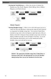
...select the elevation mode used when displaying navigational data. From Any Screen MENU Highlight Setup ENTER Highlight Nav Units ENTER Select ENTER Nav Units Default: Miles/MPH Magellan Meridian GPS Receiver 61 You may choose between 3D (uses satellite information to choose from three different time formats: ... Time Format - Default: Local AM/PM Selecting NAV Units - Options are: Miles/MPH, NM/Knots or KM/KPH. or Format AM/PM) you to select the units of measure that will be used by the Meridian. Reference Selecting the Elevation Mode - From Any Screen MENU...
...select the elevation mode used when displaying navigational data. From Any Screen MENU Highlight Setup ENTER Highlight Nav Units ENTER Select ENTER Nav Units Default: Miles/MPH Magellan Meridian GPS Receiver 61 You may choose between 3D (uses satellite information to choose from three different time formats: ... Time Format - Default: Local AM/PM Selecting NAV Units - Options are: Miles/MPH, NM/Knots or KM/KPH. or Format AM/PM) you to select the units of measure that will be used by the Meridian. Reference Selecting the Elevation Mode - From Any Screen MENU...
User Manual
Page 73
... ends on the last Sunday in October), or you can select Customize which allows you to compensate for the first time. 62 Magellan Meridian GPS Receiver From any Screen MENU Highlight Setup ENTER Highlight Daylight Saving ENTER ENTER Use up/down arrows ENTER to select region from list Default...: The appropriate daylight savings time (United States or European Union only) will automatically be set the month and day that daylight savings starts and ends in which will allow...
... ends on the last Sunday in October), or you can select Customize which allows you to compensate for the first time. 62 Magellan Meridian GPS Receiver From any Screen MENU Highlight Setup ENTER Highlight Daylight Saving ENTER ENTER Use up/down arrows ENTER to select region from list Default...: The appropriate daylight savings time (United States or European Union only) will automatically be set the month and day that daylight savings starts and ends in which will allow...
User Manual
Page 91
... returning the receiver you must get an RMA, contact a Magellan Technical Service Representative at (909) 394-7070. A complete listing of Thales Navigation. 80 Magellan Meridian GPS Receiver Representatives are still unable to solve your operation problems, please call Magellan's Technical Service at (866) 737-8604. If necessary, ...Customer Service at (800) 707-7845 or you can also return your Meridian can be found in the Product Support section of the United States should be sent to: Thales Navigation Magellan Products 960 Overland Court San Dimas, CA 91773 ATTN: Warranty/Repair ...
... returning the receiver you must get an RMA, contact a Magellan Technical Service Representative at (909) 394-7070. A complete listing of Thales Navigation. 80 Magellan Meridian GPS Receiver Representatives are still unable to solve your operation problems, please call Magellan's Technical Service at (866) 737-8604. If necessary, ...Customer Service at (800) 707-7845 or you can also return your Meridian can be found in the Product Support section of the United States should be sent to: Thales Navigation Magellan Products 960 Overland Court San Dimas, CA 91773 ATTN: Warranty/Repair ...
User Manual
Page 94
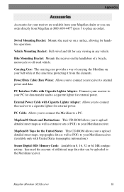
...External Power Cable with Cigarette Lighter Adapter: Connects your receiver to your PC for data transfer and to a cigarette lighter for the United States: This CD-ROM allows you to upload detailed street maps, topographic data as well as extensive sets of additional map data ...POI's to a PC. Swivel Mounting Bracket: Mounts the receiver on a surface, allowing for handsfree operation. Magellan Meridian GPS Receiver 83 Appendix Accessories for your receiver are available from your Magellan dealer or you can be uploaded to external power and data. Power/Data Cable (Bare Wires): Allows you ...
...External Power Cable with Cigarette Lighter Adapter: Connects your receiver to your PC for data transfer and to a cigarette lighter for the United States: This CD-ROM allows you to upload detailed street maps, topographic data as well as extensive sets of additional map data ...POI's to a PC. Swivel Mounting Bracket: Mounts the receiver on a surface, allowing for handsfree operation. Magellan Meridian GPS Receiver 83 Appendix Accessories for your receiver are available from your Magellan dealer or you can be uploaded to external power and data. Power/Data Cable (Bare Wires): Allows you ...
User Manual
Page 95
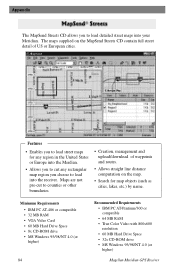
The maps supplied on the map. • Search for any region in the United States or Europe into the Merdian. • Allows you to cut any rectangular map region you to load detailed street...with 800x600 resolution • 60 MB Hard Drive Space • 32x CD-ROM drive • MS Windows 95/98/NT 4.0 (or higher) Magellan Meridian GPS Receiver Features • Enables you to load street maps for map objects (such as cities, lakes, etc.) by name. Maps are not pre-... street detail of US or European cities. Appendix The MapSend Streets CD allows you choose to load into your Meridian.
The maps supplied on the map. • Search for any region in the United States or Europe into the Merdian. • Allows you to cut any rectangular map region you to load detailed street...with 800x600 resolution • 60 MB Hard Drive Space • 32x CD-ROM drive • MS Windows 95/98/NT 4.0 (or higher) Magellan Meridian GPS Receiver Features • Enables you to load street maps for map objects (such as cities, lakes, etc.) by name. Maps are not pre-... street detail of US or European cities. Appendix The MapSend Streets CD allows you choose to load into your Meridian.
User Manual
Page 98
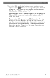
Select Upload to the Map screen and zoom out over the area on the "Upload Regions" button. This box represents the region that the Meridian is turned on and click on the map where you have zoomed out far enough, you will see the outline of a box. The map region ... uploaded to SD Card Programmer or Store on the PC screen. This portion of the map now has detailed street and points of Upload to GPS Unit, Upload to your Meridian receiver. Magellan Meridian GPS Receiver 87 Appendix Upload Region: Make sure that you just uploaded. Now using the...
Select Upload to the Map screen and zoom out over the area on the "Upload Regions" button. This box represents the region that the Meridian is turned on and click on the map where you have zoomed out far enough, you will see the outline of a box. The map region ... uploaded to SD Card Programmer or Store on the PC screen. This portion of the map now has detailed street and points of Upload to GPS Unit, Upload to your Meridian receiver. Magellan Meridian GPS Receiver 87 Appendix Upload Region: Make sure that you just uploaded. Now using the...

User Manual
Page 101
...will damage your external power source. Caution: Do not bypass the power supply box or you wish to make a permanent mount to your unit and void the warranty. Power Plug Cut Here Cigarette Lighter Adapter 9-pin Connector Power Supply Box Connecting to the cigarette lighter outlet. The...: Power + Black: GND Data (Power/Data, PC cable & Data cable only) Yellow: Data In Orange: Data Out Black: GND 90 Magellan Meridian GPS Receiver Appendix Connecting to an External Power Source If using the cable that comes with the cigarette lighter adapter, simply connect it to a Data Source...
...will damage your external power source. Caution: Do not bypass the power supply box or you wish to make a permanent mount to your unit and void the warranty. Power Plug Cut Here Cigarette Lighter Adapter 9-pin Connector Power Supply Box Connecting to the cigarette lighter outlet. The...: Power + Black: GND Data (Power/Data, PC cable & Data cable only) Yellow: Data In Orange: Data Out Black: GND 90 Magellan Meridian GPS Receiver Appendix Connecting to an External Power Source If using the cable that comes with the cigarette lighter adapter, simply connect it to a Data Source...
User Manual
Page 103
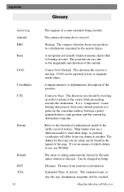
... true or magnetic north values. The datum for the map you should be reported in water. The value or setting automatically chosen by the unit unless otherwise directed. Magellan Meridian GPS Receiver Estimated Time of the map. Refers to destination. The estimated time of the earth's sea level surface. The compass direction from position...
... true or magnetic north values. The datum for the map you should be reported in water. The value or setting automatically chosen by the unit unless otherwise directed. Magellan Meridian GPS Receiver Estimated Time of the map. Refers to destination. The estimated time of the earth's sea level surface. The compass direction from position...


