User Manual
Page 2
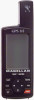
... the receiver, and will void the warranty. WARNINGS USE GOOD JUDGEMENT This product is operated by poor satellite geometry. USE PROPER ACCESSORIES Use only Magellan cables and antennas; The SOFTWARE is protected by United States copyright laws and international treaty provisions; All rights not expressly granted are trademarks of the equipment. The accuracy of Magellan Corporation. © 1999 by the U.S. Magellan™, GPS 315™, GPS...
... the receiver, and will void the warranty. WARNINGS USE GOOD JUDGEMENT This product is operated by poor satellite geometry. USE PROPER ACCESSORIES Use only Magellan cables and antennas; The SOFTWARE is protected by United States copyright laws and international treaty provisions; All rights not expressly granted are trademarks of the equipment. The accuracy of Magellan Corporation. © 1999 by the U.S. Magellan™, GPS 315™, GPS...
User Manual
Page 4
...2 Screen 12 Using the Plot Screen 13 Selecting PAN-N-SCAN 14 Setting Track History 14 Clearing Track History 14 Setting Up the Plotter 15 Setting Hide Data/Show Data 16 Using the Road Screen 17 Customizing the Road Screen 17 Using the Speed Screen 18 Resetting the Odometer 18 Resetting the Trip Odometer 19 Setting the Speed Average 19 Using the Time Screen 20 Selecting Time Format 20 Resetting Elapsed Time 21 Reference 22 Working with Waypoints 23 Creating a User Waypoint 24 Editing a User Waypoint 24 Creating/Editing/Deleting a Message in a User Waypoint 25 Saving Changes...
...2 Screen 12 Using the Plot Screen 13 Selecting PAN-N-SCAN 14 Setting Track History 14 Clearing Track History 14 Setting Up the Plotter 15 Setting Hide Data/Show Data 16 Using the Road Screen 17 Customizing the Road Screen 17 Using the Speed Screen 18 Resetting the Odometer 18 Resetting the Trip Odometer 19 Setting the Speed Average 19 Using the Time Screen 20 Selecting Time Format 20 Resetting Elapsed Time 21 Reference 22 Working with Waypoints 23 Creating a User Waypoint 24 Editing a User Waypoint 24 Creating/Editing/Deleting a Message in a User Waypoint 25 Saving Changes...
User Manual
Page 9
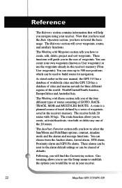
..., Getting Started, Basic Operation, Reference, Customizing, Troubleshooting and Glossary. Since introducing the world's first commercial, hand-held GPS receiver in 1989, Magellan has led the way with key sequences rather than spending hours reading the user's manual. The Reference section contains information to guide you navigate using waypoints, routes and auxiliary functions. These differ in the receiver. If any of these items are also subchapters that the GPS 315 has a database...
..., Getting Started, Basic Operation, Reference, Customizing, Troubleshooting and Glossary. Since introducing the world's first commercial, hand-held GPS receiver in 1989, Magellan has led the way with key sequences rather than spending hours reading the user's manual. The Reference section contains information to guide you navigate using waypoints, routes and auxiliary functions. These differ in the receiver. If any of these items are also subchapters that the GPS 315 has a database...
User Manual
Page 11
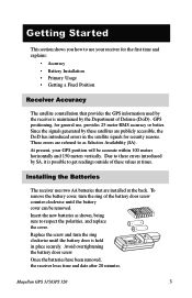
... overtightening the battery door screw. Once the batteries have been removed, the receiver loses time and date after 20 minutes. Getting Started This section shows you how to use , provides 25 meter RMS accuracy or better. GPS positioning, for general use your GPS position will be removed. Replace the screw and turn the ring of these satellites are publicly accessible, the DoD has introduced errors in place securely. Magellan GPS 315/GPS 320 3 Since...
... overtightening the battery door screw. Once the batteries have been removed, the receiver loses time and date after 20 minutes. Getting Started This section shows you how to use , provides 25 meter RMS accuracy or better. GPS positioning, for general use your GPS position will be removed. Replace the screw and turn the ring of these satellites are publicly accessible, the DoD has introduced errors in place securely. Magellan GPS 315/GPS 320 3 Since...
User Manual
Page 12
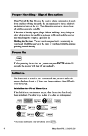
... sky is designed to compute a position fix. PWR INITIALIZE screen ENTER Select region ENTER Select area ENTER Enter * elevation ENTER Enter time ENTER Enter date ENTER * If you do not press ENTER within 10 seconds, the receiver will shut off . Signal Reception Clear View of your elevation, press ENTER . 4 Magellan GPS 315/GPS 320 Hold the receiver in this procedure are not required. The other obstructions) the satellite signals can be blocked and the receiver may take longer to fit comfortably...
... sky is designed to compute a position fix. PWR INITIALIZE screen ENTER Select region ENTER Select area ENTER Enter * elevation ENTER Enter time ENTER Enter date ENTER * If you do not press ENTER within 10 seconds, the receiver will shut off . Signal Reception Clear View of your elevation, press ENTER . 4 Magellan GPS 315/GPS 320 Hold the receiver in this procedure are not required. The other obstructions) the satellite signals can be blocked and the receiver may take longer to fit comfortably...
User Manual
Page 13
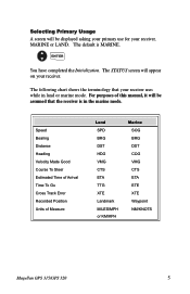
... Magellan GPS 315/GPS 320 5 Speed Bearing Distance Heading Velocity Made Good Course To Steer Estimated Time of Arrival Time To Go Cross Track Error Recorded Position Units of this manual, it will be displayed asking your primary use for your receiver, MARINE or LAND. The following chart shows the terminology that the receiver is MARINE. The STATUS screen will appear on your receiver. Selecting Primary Usage A screen will be assumed that your receiver uses while in the marine mode. The default...
... Magellan GPS 315/GPS 320 5 Speed Bearing Distance Heading Velocity Made Good Course To Steer Estimated Time of Arrival Time To Go Cross Track Error Recorded Position Units of this manual, it will be displayed asking your primary use for your receiver, MARINE or LAND. The following chart shows the terminology that the receiver is MARINE. The STATUS screen will appear on your receiver. Selecting Primary Usage A screen will be assumed that your receiver uses while in the marine mode. The default...
User Manual
Page 15
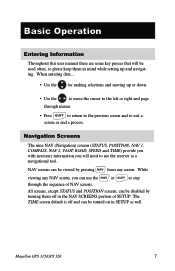
... SETUP as a navigational tool. Basic Operation Entering Information Throughout this user manual there are some key presses that will need to exit a screen or end a process. NAV screens can use the NAV or QUIT to step through menus. • Press QUIT to return to the previous screen and to use the receiver as well. Magellan GPS 315/GPS 320 7 Navigation Screens The nine NAV (Navigation) screens (STATUS, POSITION, NAV 1, COMPASS, NAV 2, PLOT, ROAD, SPEED and TIME...
... SETUP as a navigational tool. Basic Operation Entering Information Throughout this user manual there are some key presses that will need to exit a screen or end a process. NAV screens can use the NAV or QUIT to step through menus. • Press QUIT to return to the previous screen and to use the receiver as well. Magellan GPS 315/GPS 320 7 Navigation Screens The nine NAV (Navigation) screens (STATUS, POSITION, NAV 1, COMPASS, NAV 2, PLOT, ROAD, SPEED and TIME...
User Manual
Page 21
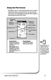
... through the PLOT screen enabling you have traveled and where you want to 200 miles. Destination Name Bearing to Destination Destination Icon Active Route Plot Scale TO: FISH BRG DST 351°m 3.52mI FISH N FISH 2 DOCK BUOY HOME 2.0 m I Distance to Destination North Indicator Waypoint Icon Current Position Icon Track History Active Route Indicates the direction required to create waypoints and GOTOs. You can view the active route, your destination.
... through the PLOT screen enabling you have traveled and where you want to 200 miles. Destination Name Bearing to Destination Destination Icon Active Route Plot Scale TO: FISH BRG DST 351°m 3.52mI FISH N FISH 2 DOCK BUOY HOME 2.0 m I Distance to Destination North Indicator Waypoint Icon Current Position Icon Track History Active Route Indicates the direction required to create waypoints and GOTOs. You can view the active route, your destination.
User Manual
Page 22
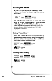
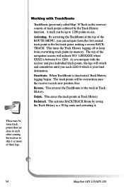
... bread crumbs" from your starting point as you want to return to your starting point. From PLOT screen MENU Select TRACK HIST ENTER Change field ENTER Clearing Track History From PLOT MENU Select screen CLR TRACK ENTER Select ENTER 14 Magellan GPS 315/GPS 320 Moving the cursor over the waypoint icon when MENU is pressed, the menu will be used to move the cursor. Pressing MENU and selecting WPT INFO displays full information. Setting Track History Using TRACK HISTORY records where you have traveled according to waypoints, routes and track history. If the cursor is...
... bread crumbs" from your starting point as you want to return to your starting point. From PLOT screen MENU Select TRACK HIST ENTER Change field ENTER Clearing Track History From PLOT MENU Select screen CLR TRACK ENTER Select ENTER 14 Magellan GPS 315/GPS 320 Moving the cursor over the waypoint icon when MENU is pressed, the menu will be used to move the cursor. Pressing MENU and selecting WPT INFO displays full information. Setting Track History Using TRACK HISTORY records where you have traveled according to waypoints, routes and track history. If the cursor is...
User Manual
Page 24
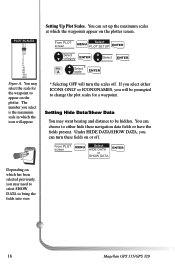
... scales off . From PLOT screen Select MENU PLOT SETUP ENTER Select category ENTER Select ENTER FIG. Setting Up Plot Scales. Under HIDE DATA/SHOW DATA, you will turn these navigation data fields or have the fields present. Setting Hide Data/Show Data You may want bearing and distance to change the plot scales for the waypoint to bring the fields into view. 16 Magellan GPS 315/GPS 320 You can choose to either ICONS ONLY or ICONS/NAMES, you can set up the maximum scales...
... scales off . From PLOT screen Select MENU PLOT SETUP ENTER Select category ENTER Select ENTER FIG. Setting Up Plot Scales. Under HIDE DATA/SHOW DATA, you will turn these navigation data fields or have the fields present. Setting Hide Data/Show Data You may want bearing and distance to change the plot scales for the waypoint to bring the fields into view. 16 Magellan GPS 315/GPS 320 You can choose to either ICONS ONLY or ICONS/NAMES, you can set up the maximum scales...
User Manual
Page 26
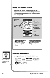
... Speed A graphical representation of speed over ground. A Select yes or no ENTER 18 Magellan GPS 315/GPS 320 YES NO Figure A. Destination Name Navigation Data TO: CAMP BRG COG 027m° 056°°mm 5 10 15 0 20 SOG 14.2 K T ODOMETER 0 0 5 4 2 2n 3 m TRIP 0 5 4 2n 3m Average Speed Icon Instantaneous Speed Graphical Speedometer Odometer Trip Odometer Graphical Speedometer Scale can view the graphical speedometer, odometer and trip odometer as well as the numerical bearing, course...
... Speed A graphical representation of speed over ground. A Select yes or no ENTER 18 Magellan GPS 315/GPS 320 YES NO Figure A. Destination Name Navigation Data TO: CAMP BRG COG 027m° 056°°mm 5 10 15 0 20 SOG 14.2 K T ODOMETER 0 0 5 4 2 2n 3 m TRIP 0 5 4 2n 3m Average Speed Icon Instantaneous Speed Graphical Speedometer Odometer Trip Odometer Graphical Speedometer Scale can view the graphical speedometer, odometer and trip odometer as well as the numerical bearing, course...
User Manual
Page 30
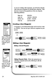
... waypoints. The route function allows you in the receiver's memory (NonUser waypoints). A route is a planned course of travel defined by a series of the 20 routes. Following, you will guide you to the alarm default settings or can be cleared of the world: North/Central/South America, Europe/Africa and Australia/Asia. These alarms can be reset to create, activate/deactivate, view/edit or delete any one of waypoints saved in the user manual, the GPS 315...
... waypoints. The route function allows you in the receiver's memory (NonUser waypoints). A route is a planned course of travel defined by a series of the 20 routes. Following, you will guide you to the alarm default settings or can be cleared of the world: North/Central/South America, Europe/Africa and Australia/Asia. These alarms can be reset to create, activate/deactivate, view/edit or delete any one of waypoints saved in the user manual, the GPS 315...
User Manual
Page 32
... CAMP FIRES SAVE EDITS CLEAR MSG Figure B. FIG. You can save up to select the edit waypoint mode. As you are divided into categories. This menu allows you will notice that can be used in a route or a GOTO. This division is a recorded position that the cities (non-user waypoints) are working with waypoints, you to 500 user waypoints in this screen. Follow the instructions on the population of the data fields in your receiver.
... CAMP FIRES SAVE EDITS CLEAR MSG Figure B. FIG. You can save up to select the edit waypoint mode. As you are divided into categories. This menu allows you will notice that can be used in a route or a GOTO. This division is a recorded position that the cities (non-user waypoints) are working with waypoints, you to 500 user waypoints in this screen. Follow the instructions on the population of the data fields in your receiver.
User Manual
Page 34
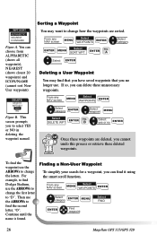
This screen prompts you can delete these unnecessary waypoints. Then use . From any NAV screen Select MENU WAYPOINTS ENTER Select category ENTER MENU ENTER Find waypoint Select FIND 26 Magellan GPS 315/GPS 320 For example, to find Dodger Stadium, use the ARROWs to change the first letter to select YES or NO in deleting the waypoint named. Continue until the name is found. From any NAV screen Select MENU WAYPOINTS ENTER Select category ENTER Select waypoint MENU Select ENTER DELETE WPT FIG. WPT SORT ALPHABETIC NEAREST ICON/NAME...
This screen prompts you can delete these unnecessary waypoints. Then use . From any NAV screen Select MENU WAYPOINTS ENTER Select category ENTER MENU ENTER Find waypoint Select FIND 26 Magellan GPS 315/GPS 320 For example, to find Dodger Stadium, use the ARROWs to change the first letter to select YES or NO in deleting the waypoint named. Continue until the name is found. From any NAV screen Select MENU WAYPOINTS ENTER Select category ENTER Select waypoint MENU Select ENTER DELETE WPT FIG. WPT SORT ALPHABETIC NEAREST ICON/NAME...

User Manual
Page 39
...can replace the stream waypoint with the fishing spot. Viewing/Editing a Route MENU MENU Select ROUTES ENTER Select route to an already existing route by highlighting the next available dotted line. Using your way back. You can add to edit Select VIEW/EDIT FIG. Select INSERT ENTER Select category ENTER VIEW/EDIT HOME CAMP Select waypoint ENTER Changing a Waypoint in the route. Select category ENTER Select waypoint ENTER Magellan GPS 315/GPS 320 31 route D Select waypoint MENU MENU ACTIVATE VIEW/EDIT REVERSE DELETE BACKTRACK PLOT VIEW WAYPOINTS ROUTES SETUP...
...can replace the stream waypoint with the fishing spot. Viewing/Editing a Route MENU MENU Select ROUTES ENTER Select route to an already existing route by highlighting the next available dotted line. Using your way back. You can add to edit Select VIEW/EDIT FIG. Select INSERT ENTER Select category ENTER VIEW/EDIT HOME CAMP Select waypoint ENTER Changing a Waypoint in the route. Select category ENTER Select waypoint ENTER Magellan GPS 315/GPS 320 31 route D Select waypoint MENU MENU ACTIVATE VIEW/EDIT REVERSE DELETE BACKTRACK PLOT VIEW WAYPOINTS ROUTES SETUP...
User Manual
Page 42
... track points collected by saving the Track History as a 30 leg route and activating it. This erases the track points in memory. Working with the receiver and pass individual track points, the legs will switch and countdown until you reach LEG 0 which is your final destination. A track can navigate from overwriting track points in Track History. By activating the TrackRoute at the top of the navigation screens will be overwritten once the receiver records new position...
... track points collected by saving the Track History as a 30 leg route and activating it. This erases the track points in memory. Working with the receiver and pass individual track points, the legs will switch and countdown until you reach LEG 0 which is your final destination. A track can navigate from overwriting track points in Track History. By activating the TrackRoute at the top of the navigation screens will be overwritten once the receiver records new position...
User Manual
Page 49
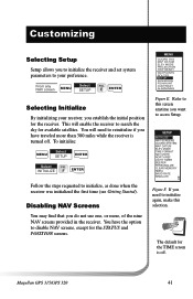
...SETUP INITIALIZE NAV SCREENS COORD SYSTEM MAP DATUM ELEV MODE TIME FORMAT NAV UNITS NORTH REF LIGHT TIMER BEEPER PERSONALIZE CLEAR MEMORY NMEA BAUD RATE SIMULATE Figure F. MENU COORD SYS MAP DATUM ELEV MODE PROJECTION TRIP RESET WAYPOINTS ROUTES SETUP SUN/MOON FISH/HUNT CONTRAST ALARM/MSG Figure E. E ENTER Selecting Initialize By initializing your preference. Refer to this selection. If you want to access Setup. You will enable the receiver to search the sky for available satellites. From any NAV screen MENU Select SETUP FIG. Customizing Selecting Setup Setup...
...SETUP INITIALIZE NAV SCREENS COORD SYSTEM MAP DATUM ELEV MODE TIME FORMAT NAV UNITS NORTH REF LIGHT TIMER BEEPER PERSONALIZE CLEAR MEMORY NMEA BAUD RATE SIMULATE Figure F. MENU COORD SYS MAP DATUM ELEV MODE PROJECTION TRIP RESET WAYPOINTS ROUTES SETUP SUN/MOON FISH/HUNT CONTRAST ALARM/MSG Figure E. E ENTER Selecting Initialize By initializing your preference. Refer to this selection. If you want to access Setup. You will enable the receiver to search the sky for available satellites. From any NAV screen MENU Select SETUP FIG. Customizing Selecting Setup Setup...
User Manual
Page 52
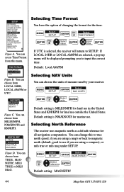
... can change this menu. NAV UNITS MILES/MPH NM/KNOTS KM/KPH Figure C. Default setting is selected, the receiver will be displayed prompting you to use if you are using a map) or back to magnetic north (default, good to input the correct time. MENU Select SETUP Select ENTER NORTH REF ENTER FIG. You can choose the units of changing the format for all navigation computation. Selecting Time Format You have the option of measure used by your receiver. MENU Select SETUP ENTER FIG. D Select reference ENTER Default setting: MAGNETIC 44 Magellan GPS 315/GPS...
... can change this menu. NAV UNITS MILES/MPH NM/KNOTS KM/KPH Figure C. Default setting is selected, the receiver will be displayed prompting you to use if you are using a map) or back to magnetic north (default, good to input the correct time. MENU Select SETUP Select ENTER NORTH REF ENTER FIG. You can choose the units of changing the format for all navigation computation. Selecting Time Format You have the option of measure used by your receiver. MENU Select SETUP ENTER FIG. D Select reference ENTER Default setting: MAGNETIC 44 Magellan GPS 315/GPS...
User Manual
Page 59
... 1/2 turn. Magellan GPS 315/GPS 320 51 Faxes can also return your receiver to solve your operation problems, please call for repair (please call Magellan's Technical Service at (909) 394-7070. Packages should be sent to Customer Service at (800) 707-9971. Contacting Magellan If after using the troubleshooting section, you are available Monday through Friday from 7 AM to 5 PM, PST. Please return the enclosed registration card...
... 1/2 turn. Magellan GPS 315/GPS 320 51 Faxes can also return your receiver to solve your operation problems, please call for repair (please call Magellan's Technical Service at (909) 394-7070. Packages should be sent to Customer Service at (800) 707-9971. Contacting Magellan If after using the troubleshooting section, you are available Monday through Friday from 7 AM to 5 PM, PST. Please return the enclosed registration card...
User Manual
Page 76
...waypoint 26 Weight, receiver 59 X XTE see Cross Track Error XTE alarm see Cross Track Error alarm U Universal Time Coordinated (UTC) 20, 44 68 Magellan GPS 315/ GPS 320 activating/deactivat ing a route 32; deleting a waypoint in a route 33; reversing 33; using Plot View in a route 32; viewing 31 S Satellite positions 8 Satellite signals 8 Setup 41 Shipping 51 Simulate Mode 9, 36 Sorting 26 Specifications 59 Speed screen 18; functions 23; editing 31; editing a message 25; clear 14, 46 TrackRoute 34 Trip Odometer, resetting 19 True North 44 Troubleshooting 49 W Waypoint creating...
...waypoint 26 Weight, receiver 59 X XTE see Cross Track Error XTE alarm see Cross Track Error alarm U Universal Time Coordinated (UTC) 20, 44 68 Magellan GPS 315/ GPS 320 activating/deactivat ing a route 32; deleting a waypoint in a route 33; reversing 33; using Plot View in a route 32; viewing 31 S Satellite positions 8 Satellite signals 8 Setup 41 Shipping 51 Simulate Mode 9, 36 Sorting 26 Specifications 59 Speed screen 18; functions 23; editing 31; editing a message 25; clear 14, 46 TrackRoute 34 Trip Odometer, resetting 19 True North 44 Troubleshooting 49 W Waypoint creating...


