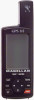
User Manual
Page 4
... 12 Using the Plot Screen 13 Selecting PAN-N-SCAN 14 Setting Track History 14 Clearing Track History 14 Setting Up the Plotter 15 Setting Hide Data/Show Data 16 Using the Road Screen 17 Customizing the Road Screen 17 Using the Speed Screen 18 Resetting the Odometer 18 Resetting the Trip Odometer...
... 12 Using the Plot Screen 13 Selecting PAN-N-SCAN 14 Setting Track History 14 Clearing Track History 14 Setting Up the Plotter 15 Setting Hide Data/Show Data 16 Using the Road Screen 17 Customizing the Road Screen 17 Using the Speed Screen 18 Resetting the Odometer 18 Resetting the Trip Odometer...

User Manual
Page 6
Selecting GPS Fix Alarm 40 Viewing the Alarm/MSG Menu 40 Selecting Alarm Defaults 40 Clearing Alarm Defaults 40 Customizing 41 Selecting Setup 41 Selecting Initialize 41 ... Selecting Personalize 45 Selecting Clear Memory 46 Selecting NMEA 46 Selecting Baud Rate 47 Connecting to DGPS 48 Troubleshooting 49 Commonly Asked Questions 50 Contacting Magellan 51 Shipping Your Receiver 51 NMEA Data Messages 52 iv
Selecting GPS Fix Alarm 40 Viewing the Alarm/MSG Menu 40 Selecting Alarm Defaults 40 Clearing Alarm Defaults 40 Customizing 41 Selecting Setup 41 Selecting Initialize 41 ... Selecting Personalize 45 Selecting Clear Memory 46 Selecting NMEA 46 Selecting Baud Rate 47 Connecting to DGPS 48 Troubleshooting 49 Commonly Asked Questions 50 Contacting Magellan 51 Shipping Your Receiver 51 NMEA Data Messages 52 iv
User Manual
Page 10
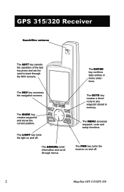
The LIGHT key turns the light on and off . The PWR key turns the receiver on and off . 2 Magellan GPS 315/GPS 320 The GOTO key creates a direct route to back through menus. The ENTER key confirms data entries or menu selections. The MARK key creates waypoints and stores the current position. The ARROWs enter information...
The LIGHT key turns the light on and off . The PWR key turns the receiver on and off . 2 Magellan GPS 315/GPS 320 The GOTO key creates a direct route to back through menus. The ENTER key confirms data entries or menu selections. The MARK key creates waypoints and stores the current position. The ARROWs enter information...
User Manual
Page 14
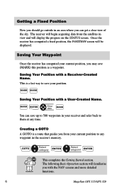
Saving Your Position with the NAV screens and more detailed functions. 6 Magellan GPS 315/GPS 320 Creating a GOTO A GOTO is a fast way to any time. MARK ENTER Enter data MARK You can get a clear view of the sky. This is a route that guides you may save your current position, ... on the STATUS screen. GOTO Select category ENTER Select waypoint ENTER This completes the Getting Started section. The receiver will begin acquiring data from your receiver and refer back to them at any waypoint in the receiver's memory. Saving Your Waypoint Once the receiver has ...
Saving Your Position with the NAV screens and more detailed functions. 6 Magellan GPS 315/GPS 320 Creating a GOTO A GOTO is a fast way to any time. MARK ENTER Enter data MARK You can get a clear view of the sky. This is a route that guides you may save your current position, ... on the STATUS screen. GOTO Select category ENTER Select waypoint ENTER This completes the Getting Started section. The receiver will begin acquiring data from your receiver and refer back to them at any waypoint in the receiver's memory. Saving Your Waypoint Once the receiver has ...
User Manual
Page 15
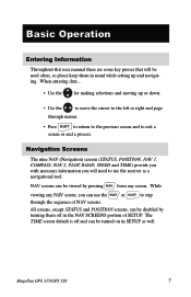
... TIME screen default is off in mind while setting up or down. • Use the to move the cursor to exit a screen or end a process. Magellan GPS 315/GPS 320 7 NAV screens can be disabled by pressing NAV from any NAV screen, you will be viewed by turning them in the NAV SCREENS portion... to return to the previous screen and to the left or right and page through the sequence of SETUP. While viewing any screen. When entering data... • Use the for making selections and moving up and navigating.
... TIME screen default is off in mind while setting up or down. • Use the to move the cursor to exit a screen or end a process. Magellan GPS 315/GPS 320 7 NAV screens can be disabled by pressing NAV from any NAV screen, you will be viewed by turning them in the NAV SCREENS portion... to return to the previous screen and to the left or right and page through the sequence of SETUP. While viewing any screen. When entering data... • Use the for making selections and moving up and navigating.
User Manual
Page 17
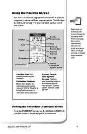
.... When you begin moving, averaging stops automatically. Second Coordinate System Access Displays your position using another coordinate system. Magellan GPS 315/GPS 320 9 You also have the option of your last computed position and basic navigation data. While averaging, the receiver continuously takes fixes to view the Second Coordinate System access screen. Once you are...
.... When you begin moving, averaging stops automatically. Second Coordinate System Access Displays your position using another coordinate system. Magellan GPS 315/GPS 320 9 You also have the option of your last computed position and basic navigation data. While averaging, the receiver continuously takes fixes to view the Second Coordinate System access screen. Once you are...
User Manual
Page 18
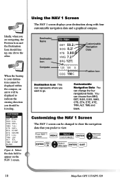
...COG, VMG, CTS, ETA, ETE, XTE, TRN, ALT, TME and blank. A Select data type ENTER QUIT 10 Magellan GPS 315/GPS 320 From NAV 1 screen MENU Select CUSTOMIZE ENTER Choose field ENTER FIG. Select the data field to go. You can change the four navigational fields. Using the NAV 1 Screen The...: FISH DST 50.2 n m SOG 8.2KT XTE 3.80nmR VMG 7.2 K T BRG 127m° 120 150 S COG 150 °m Customizable Navigation Data Position Icon Destination Icon This icon represents where you want to appear on the NAV 1 screen. Customizing the NAV 1 Screen The NAV 1 screen can be...
...COG, VMG, CTS, ETA, ETE, XTE, TRN, ALT, TME and blank. A Select data type ENTER QUIT 10 Magellan GPS 315/GPS 320 From NAV 1 screen MENU Select CUSTOMIZE ENTER Choose field ENTER FIG. Select the data field to go. You can change the four navigational fields. Using the NAV 1 Screen The...: FISH DST 50.2 n m SOG 8.2KT XTE 3.80nmR VMG 7.2 K T BRG 127m° 120 150 S COG 150 °m Customizable Navigation Data Position Icon Destination Icon This icon represents where you want to appear on the NAV 1 screen. Customizing the NAV 1 Screen The NAV 1 screen can be...
User Manual
Page 19
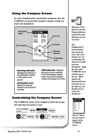
...Figure B. The NorthFinder™ feature displays sun and moon icons, above the horizon, for you should be changed to show the navigation data that you prefer to help you are traveling. Align the sun on course. The COG indicator always points up and the compass rotates according...Select CUSTOMIZE ENTER Choose field ENTER FIG. Destination Icon Shows the general direction you should travel to the COG. Select the data field to the course over ground. B Change field ENTER QUIT Magellan GPS 315/GPS 320 When the COG Indicator and the Steering Indicator point in the sky.
...Figure B. The NorthFinder™ feature displays sun and moon icons, above the horizon, for you should be changed to show the navigation data that you prefer to help you are traveling. Align the sun on course. The COG indicator always points up and the compass rotates according...Select CUSTOMIZE ENTER Choose field ENTER FIG. Destination Icon Shows the general direction you should travel to the COG. Select the data field to the course over ground. B Change field ENTER QUIT Magellan GPS 315/GPS 320 When the COG Indicator and the Steering Indicator point in the sky.
User Manual
Page 20
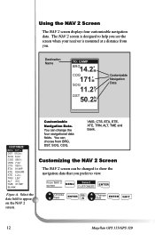
... You can be changed to show the navigation data that you see the screen when your receiver is designed to help you prefer to appear on the NAV 2 screen. A Change field ENTER QUIT 12 Magellan GPS 315/GPS 320 Select the data field to view. Destination Name TO: CAMP ...BRG14.2˚M COG 171˚M SOG 11.2 K T DST50.2NM Customizable Navigation Data CWUPSTTONAMMIZEES OBRFFG 027°m ODSNT 50.2nm SOG 8.2KT COG 056°...
... You can be changed to show the navigation data that you see the screen when your receiver is designed to help you prefer to appear on the NAV 2 screen. A Change field ENTER QUIT 12 Magellan GPS 315/GPS 320 Select the data field to view. Destination Name TO: CAMP ...BRG14.2˚M COG 171˚M SOG 11.2 K T DST50.2NM Customizable Navigation Data CWUPSTTONAMMIZEES OBRFFG 027°m ODSNT 50.2nm SOG 8.2KT COG 056°...
User Manual
Page 24
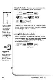
... hide these fields on the plotter screen. You can choose to either ICONS ONLY or ICONS/NAMES, you will turn these navigation data fields or have the fields present. You may select the scale for a waypoint. Setting Up Plot Scales. A Select * scale ENTER... * Selecting OFF will be hidden. Under HIDE DATA/SHOW DATA, you may want bearing and distance to be prompted to change the plot scales for the waypoint to bring the fields into view. 16 Magellan GPS 315/GPS 320 PWLPOTTNSACMAELSES OFF 0.1 ON 0.2 0.3 0.5 0.8 1 2 3 5 8 10 20...
... hide these fields on the plotter screen. You can choose to either ICONS ONLY or ICONS/NAMES, you will turn these navigation data fields or have the fields present. You may select the scale for a waypoint. Setting Up Plot Scales. A Select * scale ENTER... * Selecting OFF will be hidden. Under HIDE DATA/SHOW DATA, you may want bearing and distance to be prompted to change the plot scales for the waypoint to bring the fields into view. 16 Magellan GPS 315/GPS 320 PWLPOTTNSACMAELSES OFF 0.1 ON 0.2 0.3 0.5 0.8 1 2 3 5 8 10 20...
User Manual
Page 25
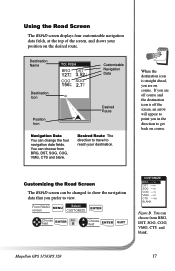
Desired Route The direction to travel to get back on course. From ROAD MENU Select screen CUSTOMIZE ENTER Choose field ENTER FIG. Magellan GPS 315/GPS 320 17 When the destination icon is off course and the destination icon is straight ahead, you prefer to view. B Choose field ENTER QUIT ... appear to point you in the direction to reach your position on course. Customizing the Road Screen The ROAD screen can change the four navigation data fields. You can choose from BRG, DST, SOG, COG, VMG, CTS and blank. If you are on the desired route. You can choose ...
Desired Route The direction to travel to get back on course. From ROAD MENU Select screen CUSTOMIZE ENTER Choose field ENTER FIG. Magellan GPS 315/GPS 320 17 When the destination icon is off course and the destination icon is straight ahead, you prefer to view. B Choose field ENTER QUIT ... appear to point you in the direction to reach your position on course. Customizing the Road Screen The ROAD screen can change the four navigation data fields. You can choose from BRG, DST, SOG, COG, VMG, CTS and blank. If you are on the desired route. You can choose ...
User Manual
Page 26
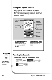
...the Odometer field to reset the odometer. Instantaneous Speed A graphical representation of speed over ground. A Select yes or no ENTER 18 Magellan GPS 315/GPS 320 Using the Speed Screen While using the SPEED screen, you can be increased or decreased by using the right/left arrows. ...From SPEED screen MENU Select ODOM RESET ENTER FIG. Destination Name Navigation Data TO: CAMP BRG COG 027m° 056°°mm 5 10 15 0 20 SOG 14.2 K T ODOMETER 0 0 5 4 2 2n 3 m TRIP 0 5 4...
...the Odometer field to reset the odometer. Instantaneous Speed A graphical representation of speed over ground. A Select yes or no ENTER 18 Magellan GPS 315/GPS 320 Using the Speed Screen While using the SPEED screen, you can be increased or decreased by using the right/left arrows. ...From SPEED screen MENU Select ODOM RESET ENTER FIG. Destination Name Navigation Data TO: CAMP BRG COG 027m° 056°°mm 5 10 15 0 20 SOG 14.2 K T ODOMETER 0 0 5 4 2 2n 3 m TRIP 0 5 4...
User Manual
Page 28
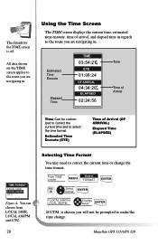
... screen displays the current time, estimated time enroute, time of arrival, and elapsed time in regards to make the time change the time format. All data shown on the TIME screen applies to the route you will not be customized to correct the current time and to correct the current time... You may need to select the time format. A Select ENTER format If LOCAL 24HR or LOCAL AM/PM Change fields ENTER If UTM is off. Magellan GPS 315/GPS 320 From TIME screen Select MENU FORMAT ENTER FIG.
... screen displays the current time, estimated time enroute, time of arrival, and elapsed time in regards to make the time change the time format. All data shown on the TIME screen applies to the route you will not be customized to correct the current time and to correct the current time... You may need to select the time format. A Select ENTER format If LOCAL 24HR or LOCAL AM/PM Change fields ENTER If UTM is off. Magellan GPS 315/GPS 320 From TIME screen Select MENU FORMAT ENTER FIG.
User Manual
Page 32
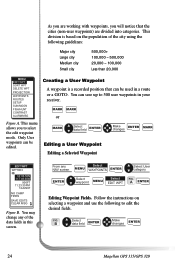
... MENU Select EDIT WPT FIG. From any of the city using the following to edit the desired fields. B Select data field ENTER Make changes ENTER 24 Magellan GPS 315/GPS 320 MARK MARK or MARK Select data field ENTER Make changes ENTER MARK Editing a User Waypoint Editing a Selected Waypoint EDIT WPT WPT003 34˚06.56N... be edited. This division is a recorded position that the cities (non-user waypoints) are divided into categories. Follow the instructions on the population of the data fields in a route or a GOTO.
... MENU Select EDIT WPT FIG. From any of the city using the following to edit the desired fields. B Select data field ENTER Make changes ENTER 24 Magellan GPS 315/GPS 320 MARK MARK or MARK Select data field ENTER Make changes ENTER MARK Editing a User Waypoint Editing a Selected Waypoint EDIT WPT WPT003 34˚06.56N... be edited. This division is a recorded position that the cities (non-user waypoints) are divided into categories. Follow the instructions on the population of the data fields in a route or a GOTO.
User Manual
Page 33
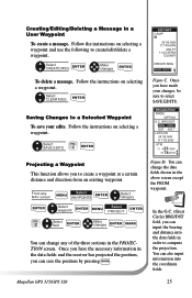
...a waypoint at a certain distance and direction from an existing waypoint. You can also input information into the data fields in the above screen except the FROM waypoint. Magellan GPS 315/GPS 320 25 Select SAVE EDITS FIG. BRG/DST BRG 000˚M DST 000 M I LAT/LON 34&#...save the position by pressing . Follow the instructions on selecting a waypoint. C ENTER Projecting a Waypoint This function allows you can change the data fields shown in order to create/edit/delete a waypoint. D Select field ENTER Make changes ENTER MARK You can save your changes, be...
...a waypoint at a certain distance and direction from an existing waypoint. You can also input information into the data fields in the above screen except the FROM waypoint. Magellan GPS 315/GPS 320 25 Select SAVE EDITS FIG. BRG/DST BRG 000˚M DST 000 M I LAT/LON 34&#...save the position by pressing . Follow the instructions on selecting a waypoint. C ENTER Projecting a Waypoint This function allows you can change the data fields shown in order to create/edit/delete a waypoint. D Select field ENTER Make changes ENTER MARK You can save your changes, be...
User Manual
Page 54
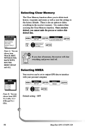
B Select NMEA ENTER Default setting: OFF 46 Magellan GPS 315/GPS 320 There is also an option to clear ENTER If you clear all memory, the receiver will clear everything... WPTS ROUTES RESET DFALT ALL Figure A. Selecting Clear Memory The Clear Memory function allows you cannot undo the process or retrieve this deleted data. Selecting NMEA Your receiver can choose from OFF, V1.5 APA, V1.5 XTE and V2.1 GSA. WPNTMNEAAMES OFF VO1N.5 APA V1.5...well as reset the settings to interface with your personal computer. You can be set to output GPS data to the factory defaults.
B Select NMEA ENTER Default setting: OFF 46 Magellan GPS 315/GPS 320 There is also an option to clear ENTER If you clear all memory, the receiver will clear everything... WPTS ROUTES RESET DFALT ALL Figure A. Selecting Clear Memory The Clear Memory function allows you cannot undo the process or retrieve this deleted data. Selecting NMEA Your receiver can choose from OFF, V1.5 APA, V1.5 XTE and V2.1 GSA. WPNTMNEAAMES OFF VO1N.5 APA V1.5...well as reset the settings to interface with your personal computer. You can be set to output GPS data to the factory defaults.
User Manual
Page 55
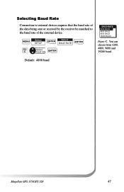
Default: 4800 baud Magellan GPS 315/GPS 320 47 MENU FIG. Selecting Baud Rate Connection to external devices requires that the baud rate of the data being sent or received by the receiver be matched to the baud rate of the external device. You can choose from 1200, 4800, 9600 and 19200 baud. C Select SETUP ENTER Select BAUD RATE ENTER Select baud rate ENTER WBAPTUDNARMATEES O12F0F0 BAUD O48N00 BAUD 9600 BAUD 19200 BAUD Figure C.
Default: 4800 baud Magellan GPS 315/GPS 320 47 MENU FIG. Selecting Baud Rate Connection to external devices requires that the baud rate of the data being sent or received by the receiver be matched to the baud rate of the external device. You can choose from 1200, 4800, 9600 and 19200 baud. C Select SETUP ENTER Select BAUD RATE ENTER Select baud rate ENTER WBAPTUDNARMATEES O12F0F0 BAUD O48N00 BAUD 9600 BAUD 19200 BAUD Figure C.
User Manual
Page 56
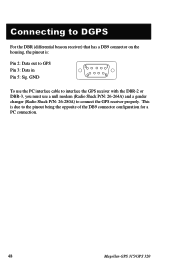
GND 5 1 9 6 To use the PC interface cable to interface the GPS receiver with the DBR-2 or DBR-3, you must use a null modem (Radio Shack P/N: 26-264A) and a gender changer (Radio Shack P/N: 26-280A) to connect the GPS receiver properly. This is : Pin 2: Data out to GPS Pin 3: Data in Pin 5: Sig. Connecting to DGPS For the DBR (differential beacon receiver) that has a DB9 connector on the housing, the pinout is due to the pinout being the opposite of the DB9 connector configuration for a PC connection. 48 Magellan GPS 315/GPS 320
GND 5 1 9 6 To use the PC interface cable to interface the GPS receiver with the DBR-2 or DBR-3, you must use a null modem (Radio Shack P/N: 26-264A) and a gender changer (Radio Shack P/N: 26-280A) to connect the GPS receiver properly. This is : Pin 2: Data out to GPS Pin 3: Data in Pin 5: Sig. Connecting to DGPS For the DBR (differential beacon receiver) that has a DB9 connector on the housing, the pinout is due to the pinout being the opposite of the DB9 connector configuration for a PC connection. 48 Magellan GPS 315/GPS 320
User Manual
Page 57
...Reference for instructions on selecting the map datum in the same format as your receiver. 2. Make sure that the antenna is in your map. Magellan GPS 315/GPS 320 49 Make sure that the format selected in COORDINATE SYSTEM (DEG/MIN/SEC or DEG/MIN.MM) is pointing up, has a clear ...of Defense called Selective Availability (SA) can be : 1. Check Satellite Status to fluctuate. Errors induced by the Department of the sky and is acquiring data. 4. The map datum is set up and down: 1. Turn the backlight off when not needed. Make sure that you are installed correctly. 2. Takes...
...Reference for instructions on selecting the map datum in the same format as your receiver. 2. Make sure that the antenna is in your map. Magellan GPS 315/GPS 320 49 Make sure that the format selected in COORDINATE SYSTEM (DEG/MIN/SEC or DEG/MIN.MM) is pointing up, has a clear ...of Defense called Selective Availability (SA) can be : 1. Check Satellite Status to fluctuate. Errors induced by the Department of the sky and is acquiring data. 4. The map datum is set up and down: 1. Turn the backlight off when not needed. Make sure that you are installed correctly. 2. Takes...
User Manual
Page 60
... true) and groundspeed (knots and KPH). 52 Magellan GPS 315/GPS 320 The baud rate can be set to 1200, 9600 or 19200. BWC GGA GLL GSA GSV RMB RMC VTG Range and bearing to destination (old format). GPS position, time, fix quality, number of satellites ... equipment to most equipment and software applications. These settings are several NMEA output message sets, each with other marine devices or equipment. Data status, cross track error, direction to steer, origin, destination landmark, landmark location, bearing to destination, and velocity toward destination, bearing...
... true) and groundspeed (knots and KPH). 52 Magellan GPS 315/GPS 320 The baud rate can be set to 1200, 9600 or 19200. BWC GGA GLL GSA GSV RMB RMC VTG Range and bearing to destination (old format). GPS position, time, fix quality, number of satellites ... equipment to most equipment and software applications. These settings are several NMEA output message sets, each with other marine devices or equipment. Data status, cross track error, direction to steer, origin, destination landmark, landmark location, bearing to destination, and velocity toward destination, bearing...