User Manual
Page 2
... U.S. All rights not expressly granted are trademarks of Defense civil GPS user policy and the Federal Radionavigation Plan. Magellan™, GPS 315™, GPS 320™ and DataSend™ are reserved by MAGELLAN and/or its suppliers and is operated by Magellan Corporation. USE PROPER ACCESSORIES Use only Magellan cables and antennas; You may be reproduced or transmitted...
... U.S. All rights not expressly granted are trademarks of Defense civil GPS user policy and the Federal Radionavigation Plan. Magellan™, GPS 315™, GPS 320™ and DataSend™ are reserved by MAGELLAN and/or its suppliers and is operated by Magellan Corporation. USE PROPER ACCESSORIES Use only Magellan cables and antennas; You may be reproduced or transmitted...
User Manual
Page 9
... for three different regions of the Magellan GPS 315/GPS 320 receiver. The Basic Operation chapter describes the features found in 1989, Magellan has led the way with key sequences rather than spending hours reading the user's manual. Magellan GPS 315/GPS 320 1 Introduction Congratulations on your ...receiver including step-by-step instructions on the box. Since introducing the world's first commercial, hand-held GPS receiver in your purchase of the world (North/ ...
... for three different regions of the Magellan GPS 315/GPS 320 receiver. The Basic Operation chapter describes the features found in 1989, Magellan has led the way with key sequences rather than spending hours reading the user's manual. Magellan GPS 315/GPS 320 1 Introduction Congratulations on your ...receiver including step-by-step instructions on the box. Since introducing the world's first commercial, hand-held GPS receiver in your purchase of the world (North/ ...
User Manual
Page 10
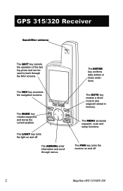
... creates a direct route to back through menus. The MENU accesses waypoint, route and setup functions. The PWR key turns the receiver on and off . 2 Magellan GPS 315/GPS 320 GPS 315/320 Receiver Quadrifilar antenna The QUIT key cancels the operation of the last key press and can be used to any waypoint stored in memory...
... creates a direct route to back through menus. The MENU accesses waypoint, route and setup functions. The PWR key turns the receiver on and off . 2 Magellan GPS 315/GPS 320 GPS 315/320 Receiver Quadrifilar antenna The QUIT key cancels the operation of the last key press and can be used to any waypoint stored in memory...
User Manual
Page 11
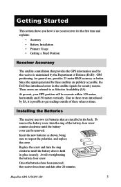
... the battery door screw. Installing the Batteries The receiver uses two AA batteries that provides the GPS information used by the receiver is held in the satellite signals for general use your GPS position will be removed. Magellan GPS 315/GPS 320 3 Since the signals generated by the Department of these satellites are publicly accessible, the...
... the battery door screw. Installing the Batteries The receiver uses two AA batteries that provides the GPS information used by the receiver is held in the satellite signals for general use your GPS position will be removed. Magellan GPS 315/GPS 320 3 Since the signals generated by the Department of these satellites are publicly accessible, the...
User Manual
Page 12
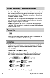
... cleared or if it needs from all satellites currently available. Signal Reception Clear View of the sky. Hold the receiver in your elevation, press ENTER . 4 Magellan GPS 315/GPS 320 Power On PWR If after powering the receiver on, you do not press ENTER within 10 seconds, the receiver will shut off . This allows...
... cleared or if it needs from all satellites currently available. Signal Reception Clear View of the sky. Hold the receiver in your elevation, press ENTER . 4 Magellan GPS 315/GPS 320 Power On PWR If after powering the receiver on, you do not press ENTER within 10 seconds, the receiver will shut off . This allows...
User Manual
Page 13
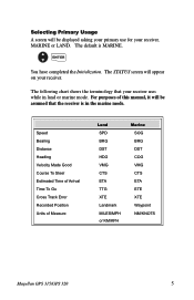
... HDG VMG CTS ETA TTG XTE Landmark MILES/MPH or KM/KPH Marine SOG BRG DST COG VMG CTS ETA ETE XTE Waypoint NM/KNOTS Magellan GPS 315/GPS 320 5 The following chart shows the terminology that the receiver is MARINE. Selecting Primary Usage A screen will be assumed that your receiver uses while in...
... HDG VMG CTS ETA TTG XTE Landmark MILES/MPH or KM/KPH Marine SOG BRG DST COG VMG CTS ETA ETE XTE Waypoint NM/KNOTS Magellan GPS 315/GPS 320 5 The following chart shows the terminology that the receiver is MARINE. Selecting Primary Usage A screen will be assumed that your receiver uses while in...
User Manual
Page 14
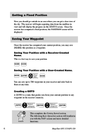
... current position to any time. Saving Your Waypoint Once the receiver has computed your current position, you with the NAV screens and more detailed functions. 6 Magellan GPS 315/GPS 320 GOTO Select category ENTER Select waypoint ENTER This completes the Getting Started section. This is a route that guides you can save up to 500...
... current position to any time. Saving Your Waypoint Once the receiver has computed your current position, you with the NAV screens and more detailed functions. 6 Magellan GPS 315/GPS 320 GOTO Select category ENTER Select waypoint ENTER This completes the Getting Started section. This is a route that guides you can save up to 500...
User Manual
Page 15
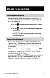
... 1, COMPASS, NAV 2, PLOT, ROAD, SPEED and TIME) provide you with necessary information you can be turned on in the NAV SCREENS portion of NAV screens. Magellan GPS 315/GPS 320 7 While viewing any screen. The TIME screen default is off in SETUP as a navigational tool. Basic Operation Entering Information Throughout this user manual there...
... 1, COMPASS, NAV 2, PLOT, ROAD, SPEED and TIME) provide you with necessary information you can be turned on in the NAV SCREENS portion of NAV screens. Magellan GPS 315/GPS 320 7 While viewing any screen. The TIME screen default is off in SETUP as a navigational tool. Basic Operation Entering Information Throughout this user manual there...

User Manual
Page 16
... satellite signal strengths shown in the receiver. When the receiver first tracks a satellite, the strength bar will not be solid until ephemeris is 90˚. 8 Magellan GPS 315/GPS 320 Satellite Position Graph The two circles indicate satellite elevation, the outer circle represents the horizon and the inner circle represents 45˚ from the...
... satellite signal strengths shown in the receiver. When the receiver first tracks a satellite, the strength bar will not be solid until ephemeris is 90˚. 8 Magellan GPS 315/GPS 320 Satellite Position Graph The two circles indicate satellite elevation, the outer circle represents the horizon and the inner circle represents 45˚ from the...
User Manual
Page 17
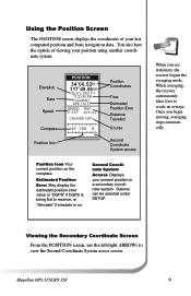
... System access Position Icon Your current position on . When you begin moving, averaging stops automatically. Once you are stationary, the receiver begins the averaging mode. Magellan GPS 315/GPS 320 9 Estimated Position Error May display the estimated position error value or "DGPS" if DGPS is being fed to receiver, or "Simulate" if simulate is...
... System access Position Icon Your current position on . When you begin moving, averaging stops automatically. Once you are stationary, the receiver begins the averaging mode. Magellan GPS 315/GPS 320 9 Estimated Position Error May display the estimated position error value or "DGPS" if DGPS is being fed to receiver, or "Simulate" if simulate is...
User Manual
Page 18
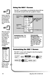
... Icon This icon represents where you prefer to your destination along with four customizable navigation data and a graphical compass. A Select data type ENTER QUIT 10 Magellan GPS 315/GPS 320 CWUPSTTONAMMIZEES OBRFFG 027°m ODSNT 50.2nm SOG 8.2KT COG 056°m VMG 7.2KT CTS 028°m ETA 01:09P ETE 02H24M XTE L.2nm...
... Icon This icon represents where you prefer to your destination along with four customizable navigation data and a graphical compass. A Select data type ENTER QUIT 10 Magellan GPS 315/GPS 320 CWUPSTTONAMMIZEES OBRFFG 027°m ODSNT 50.2nm SOG 8.2KT COG 056°m VMG 7.2KT CTS 028°m ETA 01:09P ETE 02H24M XTE L.2nm...
User Manual
Page 19
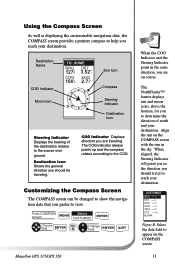
... Figure B. Using the Compass Screen As well as displaying the customizable navigation data, the COMPASS screen provides a pointer compass to view. B Change field ENTER QUIT Magellan GPS 315/GPS 320 When the COG Indicator and the Steering Indicator point in the same direction, you to determine the direction of the destination relative to appear...
... Figure B. Using the Compass Screen As well as displaying the customizable navigation data, the COMPASS screen provides a pointer compass to view. B Change field ENTER QUIT Magellan GPS 315/GPS 320 When the COG Indicator and the Steering Indicator point in the same direction, you to determine the direction of the destination relative to appear...
User Manual
Page 20
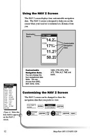
...° 83 F T 01:09P BLANK Customizable Navigation Data. You can change the four navigational data fields. Choose field ENTER FIG. A Change field ENTER QUIT 12 Magellan GPS 315/GPS 320 The NAV 2 screen is designed to show the navigation data that you . Customizing the NAV 2 Screen The NAV 2 screen can be changed to help...
...° 83 F T 01:09P BLANK Customizable Navigation Data. You can change the four navigational data fields. Choose field ENTER FIG. A Change field ENTER QUIT 12 Magellan GPS 315/GPS 320 The NAV 2 screen is designed to show the navigation data that you . Customizing the NAV 2 Screen The NAV 2 screen can be changed to help...
User Manual
Page 21
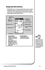
..., an additional feature, allows you to scroll through the PLOT screen enabling you to 200 miles. The scale ranges from .1 to create waypoints and GOTOs. Magellan GPS 315/GPS 320 13 Destination Name Bearing to Destination Destination Icon Active Route Plot Scale TO: FISH BRG DST 351°m 3.52mI FISH N FISH 2 DOCK BUOY HOME...
..., an additional feature, allows you to scroll through the PLOT screen enabling you to 200 miles. The scale ranges from .1 to create waypoints and GOTOs. Magellan GPS 315/GPS 320 13 Destination Name Bearing to Destination Destination Icon Active Route Plot Scale TO: FISH BRG DST 351°m 3.52mI FISH N FISH 2 DOCK BUOY HOME...
User Manual
Page 22
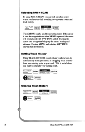
From PLOT screen MENU Select TRACK HIST ENTER Change field ENTER Clearing Track History From PLOT MENU Select screen CLR TRACK ENTER Select ENTER 14 Magellan GPS 315/GPS 320 Moving the cursor over the waypoint icon when MENU is pressed, the menu will be used to move the cursor. Setting Track History Using ...
From PLOT screen MENU Select TRACK HIST ENTER Change field ENTER Clearing Track History From PLOT MENU Select screen CLR TRACK ENTER Select ENTER 14 Magellan GPS 315/GPS 320 Moving the cursor over the waypoint icon when MENU is pressed, the menu will be used to move the cursor. Setting Track History Using ...
User Manual
Page 23
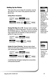
... Course Projection. B Select time ENTER A solid black line will be after a specified period of the screen). PWRPOTJENCATMIOESN OFF 1OMN INUTE 2 MINUTES 5 MINUTES 10 MINUTES Figure B. Magellan GPS 315/GPS 320 15 You may want to know where you will appear starting from OFF, 1, 2, 5 and 10 minutes. From PLOT screen MENU Select PLOT SETUP ENTER...
... Course Projection. B Select time ENTER A solid black line will be after a specified period of the screen). PWRPOTJENCATMIOESN OFF 1OMN INUTE 2 MINUTES 5 MINUTES 10 MINUTES Figure B. Magellan GPS 315/GPS 320 15 You may want to know where you will appear starting from OFF, 1, 2, 5 and 10 minutes. From PLOT screen MENU Select PLOT SETUP ENTER...
User Manual
Page 24
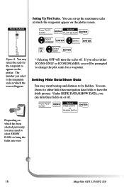
... fields on the plotter. You can turn the scales off . Under HIDE DATA/SHOW DATA, you can choose to bring the fields into view. 16 Magellan GPS 315/GPS 320 Setting Up Plot Scales. From PLOT screen Select MENU PLOT SETUP ENTER Select category ENTER Select ENTER FIG. PWLPOTTNSACMAELSES OFF 0.1 ON 0.2 0.3 0.5 0.8 1 2 3 5 8 10 20 50...
... fields on the plotter. You can turn the scales off . Under HIDE DATA/SHOW DATA, you can choose to bring the fields into view. 16 Magellan GPS 315/GPS 320 Setting Up Plot Scales. From PLOT screen Select MENU PLOT SETUP ENTER Select category ENTER Select ENTER FIG. PWLPOTTNSACMAELSES OFF 0.1 ON 0.2 0.3 0.5 0.8 1 2 3 5 8 10 20 50...
User Manual
Page 25
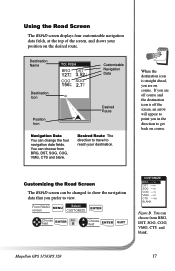
... 2.7 K T Position Icon Customizable Navigation Data Desired Route Navigation Data You can be changed to show the navigation data that you in the direction to view. Magellan GPS 315/GPS 320 17 Desired Route The direction to travel to reach your position on course. Customizing the Road Screen The ROAD screen can change the four...
... 2.7 K T Position Icon Customizable Navigation Data Desired Route Navigation Data You can be changed to show the navigation data that you in the direction to view. Magellan GPS 315/GPS 320 17 Desired Route The direction to travel to reach your position on course. Customizing the Road Screen The ROAD screen can change the four...
User Manual
Page 26
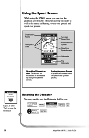
... the Odometer You may want to reset the Odometer field to reset the odometer. WARNING RESET ODOMETER TO 000? A Select yes or no ENTER 18 Magellan GPS 315/GPS 320 Instantaneous Speed A graphical representation of speed over ground. Select "Yes" to zero. Destination Name Navigation Data TO: CAMP BRG COG 027m° 056°...
... the Odometer You may want to reset the Odometer field to reset the odometer. WARNING RESET ODOMETER TO 000? A Select yes or no ENTER 18 Magellan GPS 315/GPS 320 Instantaneous Speed A graphical representation of speed over ground. Select "Yes" to zero. Destination Name Navigation Data TO: CAMP BRG COG 027m° 056°...
User Manual
Page 27
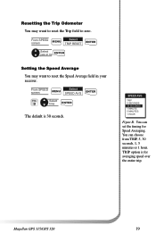
... Speed Average field in your receiver. You can choose from TRIP, 5, 30 seconds, 1, 5 minutes or 1 hour. From SPEED screen MENU Select SPEED AVG ENTER FIG. Magellan GPS 315/GPS 320 19 TRIP option is 30 seconds. B Select time ENTER The default is for Speed Averaging. SPEED AVG TRIP 5 SECONDS 30 SECONDS 1 MINUTE 5 MINUTES 1 HOUR...
... Speed Average field in your receiver. You can choose from TRIP, 5, 30 seconds, 1, 5 minutes or 1 hour. From SPEED screen MENU Select SPEED AVG ENTER FIG. Magellan GPS 315/GPS 320 19 TRIP option is 30 seconds. B Select time ENTER The default is for Speed Averaging. SPEED AVG TRIP 5 SECONDS 30 SECONDS 1 MINUTE 5 MINUTES 1 HOUR...


