

User Manual
Page 4
..., including photocopying and recording, for use without the prior written permission of Defense civil GPS user policy and the Federal Radionavigation Plan. the use of non-Magellan cables and antennas may not use the software supplied in which is operated by United States copyright laws and international treaty provisions; USE CARE The Global Positioning System (GPS) is solely responsible for the accuracy and maintenance of...
..., including photocopying and recording, for use without the prior written permission of Defense civil GPS user policy and the Federal Radionavigation Plan. the use of non-Magellan cables and antennas may not use the software supplied in which is operated by United States copyright laws and international treaty provisions; USE CARE The Global Positioning System (GPS) is solely responsible for the accuracy and maintenance of...
User Manual
Page 7
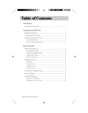
...This User Manual ...1 Setting Up the MAP 330 Installing the Batteries ...3 Connecting the Wrist Strap ...4 Initialization for First Time Use ...5 Turn the MAP 330 On ...5 Enter Your Approximate Position ...6 Basic Operation MAP 330 GPS Receiver ...9 Turning Power On/Off ...10 Turning the Backlight On/Off ...11 Adjusting the Contrast ...11 Getting a Position Fix ...12 Navigational Screens ...12 Map Screen ...12 Compass Screen ...13 Large Data Screen ...13 Position Screens ...13 Accessing the Navigation Screens ...14 Saving a Waypoint ...15 Using GOTO Routes ...18 Creating a GOTO Route ...18...
...This User Manual ...1 Setting Up the MAP 330 Installing the Batteries ...3 Connecting the Wrist Strap ...4 Initialization for First Time Use ...5 Turn the MAP 330 On ...5 Enter Your Approximate Position ...6 Basic Operation MAP 330 GPS Receiver ...9 Turning Power On/Off ...10 Turning the Backlight On/Off ...11 Adjusting the Contrast ...11 Getting a Position Fix ...12 Navigational Screens ...12 Map Screen ...12 Compass Screen ...13 Large Data Screen ...13 Position Screens ...13 Accessing the Navigation Screens ...14 Saving a Waypoint ...15 Using GOTO Routes ...18 Creating a GOTO Route ...18...
User Manual
Page 8
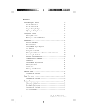
...Information or Data Fields for Nav Information ...29 Customizing the Data Fields ...29 Data Field Options Definitions ...30 Changing the Map Orientation ...31 Track History ...31 Turning On/Off Map Track View ...31 Selecting Track Mode ...31 Clearing Track ...32 Selecting Land or Marine Use ...32 Compass Screen ...33 Customizing the Data Fields ...34 Large Data Screen ...34 Customizing the Data Fields ...35 Position Screen ...35 Selecting the Position Screen ...35 Resetting the Trip Odometer ...35 Customizing the Data Fields ...37 GPS Status Messages ...37 ii Magellan MAP 330 GPS Receiver
...Information or Data Fields for Nav Information ...29 Customizing the Data Fields ...29 Data Field Options Definitions ...30 Changing the Map Orientation ...31 Track History ...31 Turning On/Off Map Track View ...31 Selecting Track Mode ...31 Clearing Track ...32 Selecting Land or Marine Use ...32 Compass Screen ...33 Customizing the Data Fields ...34 Large Data Screen ...34 Customizing the Data Fields ...35 Position Screen ...35 Selecting the Position Screen ...35 Resetting the Trip Odometer ...35 Customizing the Data Fields ...37 GPS Status Messages ...37 ii Magellan MAP 330 GPS Receiver
User Manual
Page 13
... the MAP 330 for replacement items. This User Manual is divided into the receiver's database. Setting Up the MAP 330: This chapter will want to equip the outdoorsman and consumer markets with turn-by -step instructions for you can tell which ones are right for using a GOTO. Magellan MAP 330 GPS Receiver 1 The MAP 330M has all the features that will explain getting a position fix, viewing the Map screen, saving a waypoint and using...
... the MAP 330 for replacement items. This User Manual is divided into the receiver's database. Setting Up the MAP 330: This chapter will want to equip the outdoorsman and consumer markets with turn-by -step instructions for you can tell which ones are right for using a GOTO. Magellan MAP 330 GPS Receiver 1 The MAP 330M has all the features that will explain getting a position fix, viewing the Map screen, saving a waypoint and using...
User Manual
Page 14
... chapter is set up in a way that you are completely satisfied with the specifications and features that may find step-by mail. 2 Magellan MAP 330 GPS Receiver Glossary: A glossary is to be overwhelmed with the size of the manual as provide the experienced users with your MAP 330, the global positioning system (GPS) and using your MAP 330 to external devices, accessories, troubleshooting and specifications can quickly and easily...
... chapter is set up in a way that you are completely satisfied with the specifications and features that may find step-by mail. 2 Magellan MAP 330 GPS Receiver Glossary: A glossary is to be overwhelmed with the size of the manual as provide the experienced users with your MAP 330, the global positioning system (GPS) and using your MAP 330 to external devices, accessories, troubleshooting and specifications can quickly and easily...
User Manual
Page 17
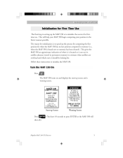
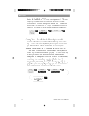
... approximate indication of where it is located so it can use . Follow these instructions to initialize the MAP 330. This will shut off.) Magellan MAP 330 GPS Receiver 5 Press The MAP 330 turns on and displays the start-up Screen Press ENTER Warning Screen (You have 10 seconds to press ENTER or the MAP 330 will help your MAP 330 begin computing your position in the fastest manner possible...
... approximate indication of where it is located so it can use . Follow these instructions to initialize the MAP 330. This will shut off.) Magellan MAP 330 GPS Receiver 5 Press The MAP 330 turns on and displays the start-up Screen Press ENTER Warning Screen (You have 10 seconds to press ENTER or the MAP 330 will help your MAP 330 begin computing your position in the fastest manner possible...
User Manual
Page 21
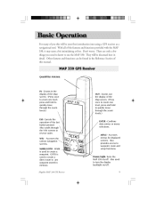
... Map screen. (Press once to zoom one level, press and hold to quickly move through the NAV screens in the Reference Section of the features and functions provided with the MAP 330, it may seem a bit intimidating at first. Accesses the various navigation screens. Also provides access to create a waypoint. Also used to waypoint, route and setup functions. MARK/GOTO - Quadrifilar Antenna IN - Magellan MAP 330 GPS Receiver ENTER - Confirms data entries or menu selections...
... Map screen. (Press once to zoom one level, press and hold to quickly move through the NAV screens in the Reference Section of the features and functions provided with the MAP 330, it may seem a bit intimidating at first. Accesses the various navigation screens. Also provides access to create a waypoint. Also used to waypoint, route and setup functions. MARK/GOTO - Quadrifilar Antenna IN - Magellan MAP 330 GPS Receiver ENTER - Confirms data entries or menu selections...
User Manual
Page 27
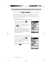
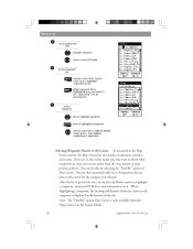
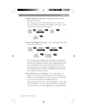
... Reference chapter.) Saving a Waypoint with a Receiver-Generated Name From any screen, press and hold MARK for 2 seconds and the Mark screen is displayed. Magellan MAP 330 GPS Receiver 15 They are primarily used for 2 seconds. Saving a Waypoint with a User-Input Icon and Name From any screen, press and hold MARK for creating routes. The "Save" button is highlighted and you can name and save the waypoint using the UP/DOWN arrows. Press ENTER . Highlight the Icon field using the default name and icon. Use...
... Reference chapter.) Saving a Waypoint with a Receiver-Generated Name From any screen, press and hold MARK for 2 seconds and the Mark screen is displayed. Magellan MAP 330 GPS Receiver 15 They are primarily used for 2 seconds. Saving a Waypoint with a User-Input Icon and Name From any screen, press and hold MARK for creating routes. The "Save" button is highlighted and you can name and save the waypoint using the UP/DOWN arrows. Press ENTER . Highlight the Icon field using the default name and icon. Use...
User Manual
Page 43
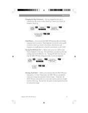
... travel, the MAP 330 automatically saves hidden waypoints into its memory. From the MAP Screen MENU Highlight Map Setup ENTER Use arrows to highlight the "Track View" field ENTER Use arrows to select the desired Map Orientation ENTER NAV Track History - In "Auto" (Automatic), the MAP 330 uses a method for track point storage. Reference Changing the Map Orientation - Default is just not displayed. As you started. Magellan MAP 330 GPS Receiver 31 These waypoints can then be used to guide you back to either North Up, Course Up or Track Up. Turning On/Off Track View...
... travel, the MAP 330 automatically saves hidden waypoints into its memory. From the MAP Screen MENU Highlight Map Setup ENTER Use arrows to highlight the "Track View" field ENTER Use arrows to select the desired Map Orientation ENTER NAV Track History - In "Auto" (Automatic), the MAP 330 uses a method for track point storage. Reference Changing the Map Orientation - Default is just not displayed. As you started. Magellan MAP 330 GPS Receiver 31 These waypoints can then be used to guide you back to either North Up, Course Up or Track Up. Turning On/Off Track View...
User Manual
Page 44
... used to create a backtrack route. ENTER 32 Magellan MAP 330 GPS Receiver It is shown in case you will not allow you would reset the track history at the start of the track points stored in the Map Setup option. As a default, the MAP 330 is how you to compute a backtrack route. From the MAP Screen MENU Highlight Map Setup ENTER Highlight Primary Usage ENTER Use U/D arrows to "OFF" stops recording your track. This is in the "Land Mode." Reference Setting the Track Mode to select Marine...
... used to create a backtrack route. ENTER 32 Magellan MAP 330 GPS Receiver It is shown in case you will not allow you would reset the track history at the start of the track points stored in the Map Setup option. As a default, the MAP 330 is how you to compute a backtrack route. From the MAP Screen MENU Highlight Map Setup ENTER Highlight Primary Usage ENTER Use U/D arrows to "OFF" stops recording your track. This is in the "Land Mode." Reference Setting the Track Mode to select Marine...
User Manual
Page 52
... of operation, position and cursor. When highlighting a waypoint, the bearing and distance from "QuickFind" box to highlight waypoints in list While waypoint list is highlighted, you can return to the waypoint is in the Map Screen section, the Map Screen has two modes of waypoints that are near your present position. Reference 1 Scroll Quick-Find Box Changes character Moves cursor left or right to display long names. ESC 3 Select Waypoint Moves highlight...
... of operation, position and cursor. When highlighting a waypoint, the bearing and distance from "QuickFind" box to highlight waypoints in list While waypoint list is highlighted, you can return to the waypoint is in the Map Screen section, the Map Screen has two modes of waypoints that are near your present position. Reference 1 Scroll Quick-Find Box Changes character Moves cursor left or right to display long names. ESC 3 Select Waypoint Moves highlight...
User Manual
Page 53
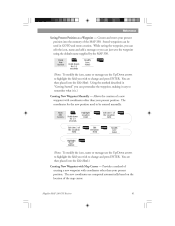
... memory of a new waypoint with coordinates other than your present position. Creates and stores your present position. The new coordinates are then placed into the Edit Mode.) Creating New Waypoint with Map Cursor - You are then placed into the Edit Mode. Magellan MAP 330 GPS Receiver 41 Stored waypoints can edit the icon, name and add a message or you wish to highlight the field you can just save the waypoint using the default name supplied by the MAP 330. Reference Saving Present Position as a Waypoint...
... memory of a new waypoint with coordinates other than your present position. Creates and stores your present position. The new coordinates are then placed into the Edit Mode.) Creating New Waypoint with Map Cursor - You are then placed into the Edit Mode. Magellan MAP 330 GPS Receiver 41 Stored waypoints can edit the icon, name and add a message or you wish to highlight the field you can just save the waypoint using the default name supplied by the MAP 330. Reference Saving Present Position as a Waypoint...
User Manual
Page 54
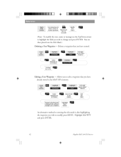
... arrows select "Find By" ENTER Select Waypoint to modify press MENU. Reference From Map Screen Use arrow keys to move cursor to desired position MARK Hold down for 2-3 seconds Modify (see Note) ENTER (Note: To modify the icon, name or message use the Up/Down arrows to highlight the field you wish to edit a waypoint that you have already stored in the MAP 330's memory. You are complete Highlight "Save" button ENTER An...
... arrows select "Find By" ENTER Select Waypoint to modify press MENU. Reference From Map Screen Use arrow keys to move cursor to desired position MARK Hold down for 2-3 seconds Modify (see Note) ENTER (Note: To modify the icon, name or message use the Up/Down arrows to highlight the field you wish to edit a waypoint that you have already stored in the MAP 330's memory. You are complete Highlight "Save" button ENTER An...
User Manual
Page 55
... Database ENTER Select Database Category ENTER Select Waypoint from the list. Follow the instructions above for viewing map objects (cities, airports, etc.) only. Saves a Map Object as a User Waypoint - This is in your changes. Saving a Map Object as a waypoint to highlight "View" button ENTER Note: If the waypoint is used to edit the waypoint and it is because the screen that you make to record your User Waypoint List. You would do this feature using User waypoints. Also note that any field...
... Database ENTER Select Database Category ENTER Select Waypoint from the list. Follow the instructions above for viewing map objects (cities, airports, etc.) only. Saves a Map Object as a User Waypoint - This is in your changes. Saving a Map Object as a waypoint to highlight "View" button ENTER Note: If the waypoint is used to edit the waypoint and it is because the screen that you make to record your User Waypoint List. You would do this feature using User waypoints. Also note that any field...
User Manual
Page 57
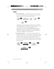
... the waypoint database. Creating a Backtrack Route - From Any Screen MENU Highlight Routes ENTER Select "Backtrack" from List ENTER GOTO routes are being instructed to "retrace" your steps. Creates and sets as the active route a 1-leg route with your MAP 330 off and then back on completing the route. Also note that you turn your MAP 330 turned on and computing position fixes. You can select only those waypoints in memory. Reference Creating a GOTO Route - From Any Screen GOTO...
... the waypoint database. Creating a Backtrack Route - From Any Screen MENU Highlight Routes ENTER Select "Backtrack" from List ENTER GOTO routes are being instructed to "retrace" your steps. Creates and sets as the active route a 1-leg route with your MAP 330 off and then back on completing the route. Also note that you turn your MAP 330 turned on and computing position fixes. You can select only those waypoints in memory. Reference Creating a GOTO Route - From Any Screen GOTO...
User Manual
Page 74
... final set of four satellites are needed to compute the position and at the same time, elevation is computed by the MAP 330 during 2D operation is the elevation you need to be using at the same time. (You should always make sure that expressed the same time as 0-99 and DEG/MIN/ MMM is setup to go into Setup - 62 Magellan MAP 330 GPS Receiver Which...
... final set of four satellites are needed to compute the position and at the same time, elevation is computed by the MAP 330 during 2D operation is the elevation you need to be using at the same time. (You should always make sure that expressed the same time as 0-99 and DEG/MIN/ MMM is setup to go into Setup - 62 Magellan MAP 330 GPS Receiver Which...
User Manual
Page 78
... receiver is a reasonable distance away from your LAT/LON format. Move the receiver to a new location to see if batteries are using . Turn the backlight off unexpectedly Position coordinates on your receiver do not rely completely on selecting the map datum in the map legend. It could be due to excessive use the same datum as the map you removed the batteries or removed external power with two new AA alkaline batteries. Use map data for instructions on it should operate...
... receiver is a reasonable distance away from your LAT/LON format. Move the receiver to a new location to see if batteries are using . Turn the backlight off unexpectedly Position coordinates on your receiver do not rely completely on selecting the map datum in the map legend. It could be due to excessive use the same datum as the map you removed the batteries or removed external power with two new AA alkaline batteries. Use map data for instructions on it should operate...
User Manual
Page 81
... 91773 ATTN: Warranty/Repair Additional information regarding software updates to solve your MAP 330 can be found in for technical support, you must get an RMA, contact a Magellan Technical Service Representative at (800) 707-7845 or you come to Customer Service at (866) 737-8604. If necessary, you . Representatives are still unable to your operation problems, please call Magellan's Technical Service at (909) 394...
... 91773 ATTN: Warranty/Repair Additional information regarding software updates to solve your MAP 330 can be found in for technical support, you must get an RMA, contact a Magellan Technical Service Representative at (800) 707-7845 or you come to Customer Service at (866) 737-8604. If necessary, you . Representatives are still unable to your operation problems, please call Magellan's Technical Service at (909) 394...
User Manual
Page 87
... Datum Default DST ETA Magellan MAP 330 GPS Receiver Refers to the theoretical mathematical model of which datum to use, use a different model to the course while proceeding towards the destination. If you are unsure of the earth's sea level surface. The current elevation above sea level. It is a "compromise" course bearing that is moving. Can be found in water. The compass direction from position to another. The direction the receiver is floating in marine...
... Datum Default DST ETA Magellan MAP 330 GPS Receiver Refers to the theoretical mathematical model of which datum to use, use a different model to the course while proceeding towards the destination. If you are unsure of the earth's sea level surface. The current elevation above sea level. It is a "compromise" course bearing that is moving. Can be found in water. The compass direction from position to another. The direction the receiver is floating in marine...
User Manual
Page 92
date changing 57; saving 15, 41; Appendix Satellite Status Screen 37 Setup 50 Signal Strength 37 Simulator 60; mode 31 Trip Odometer 36; appending to route 50 Wrist strap 4 80 Magellan MAP 330 GPS Receiver position changing 57 Technical Support 69 Time, setting 53 Time Format, selecting 53 Track History display 31; clearing 31, 56; creating with cursor 41; number of 17; turning on 60; creating manually 41; deleting 45; editing 42; icons 67; user mode 60 Specifications 70 Sun/Moon screen, accessing 57; turning off 60; preloaded 63; resetting 35 Waypoints, ...
date changing 57; saving 15, 41; Appendix Satellite Status Screen 37 Setup 50 Signal Strength 37 Simulator 60; mode 31 Trip Odometer 36; appending to route 50 Wrist strap 4 80 Magellan MAP 330 GPS Receiver position changing 57 Technical Support 69 Time, setting 53 Time Format, selecting 53 Track History display 31; clearing 31, 56; creating with cursor 41; number of 17; turning on 60; creating manually 41; deleting 45; editing 42; icons 67; user mode 60 Specifications 70 Sun/Moon screen, accessing 57; turning off 60; preloaded 63; resetting 35 Waypoints, ...


