
User Manual
Page 8
... Selecting Track Mode ...31 Clearing Track ...32 Selecting Land or Marine Use ...32 Compass Screen ...33 Customizing the Data Fields ...34 Large Data Screen ...34 Customizing the Data Fields ...35 Position Screen ...35 Selecting the Position Screen ...35 Resetting the Trip Odometer ...35 Customizing the Data Fields ...37 GPS Status Messages ...37 ii Magellan MAP 330 GPS...
... Selecting Track Mode ...31 Clearing Track ...32 Selecting Land or Marine Use ...32 Compass Screen ...33 Customizing the Data Fields ...34 Large Data Screen ...34 Customizing the Data Fields ...35 Position Screen ...35 Selecting the Position Screen ...35 Resetting the Trip Odometer ...35 Customizing the Data Fields ...37 GPS Status Messages ...37 ii Magellan MAP 330 GPS...
User Manual
Page 9
...Position as a Waypoint ...41 Creating New Waypoint Manually ...41 Creating New Waypoint with Map Cursor ...41 Deleting a User Waypoint ...42 Editing a User Waypoint ...42 Viewing a Map Object on the Map ...43 Viewing a User Waypoint on the Map ...43 Saving a Map Object as a User Waypoint ...43 Searching for a Street Address ...44 Routes ...45... a Leg ...49 Appending a Leg ...50 Appending a Newly Created Waypoint to a Route ...50 Reversing a Route ...50 Deleting a Route ...50 Viewing a Route on the Map Screen ...51 Creating a Route using Track History ...51 Magellan MAP 330 GPS Receiver iii
...Position as a Waypoint ...41 Creating New Waypoint Manually ...41 Creating New Waypoint with Map Cursor ...41 Deleting a User Waypoint ...42 Editing a User Waypoint ...42 Viewing a Map Object on the Map ...43 Viewing a User Waypoint on the Map ...43 Saving a Map Object as a User Waypoint ...43 Searching for a Street Address ...44 Routes ...45... a Leg ...49 Appending a Leg ...50 Appending a Newly Created Waypoint to a Route ...50 Reversing a Route ...50 Deleting a Route ...50 Viewing a Route on the Map Screen ...51 Creating a Route using Track History ...51 Magellan MAP 330 GPS Receiver iii
User Manual
Page 10
... Message ...55 Selecting the Baud Rate ...55 Clearing Memory ...56 Clearing Track History ...56 Clearing Wpts/Routes ...56 Clearing All Routes ...56 Resetting MAP 330 to Factory Defaults ...56 Clearing All Memory in the MAP 330 ...56 Sun/Moon Display ...57 Accessing the Sun/Moon Screen ...57 Changing......58 Accessing the Fish/Hunt Screen ...58 Changing the Fish/Hunt Date ...58 Changing the Fish/Hunt Position ...58 MAP 330 Alarms ...59 Setting the Arrival Alarm ...59 Setting the Anchor Alarm ...59 Setting the XTE Alarm ...59 Setting the GPS Fix Alarm ...59 iv Magellan MAP 330 GPS Receiver
... Message ...55 Selecting the Baud Rate ...55 Clearing Memory ...56 Clearing Track History ...56 Clearing Wpts/Routes ...56 Clearing All Routes ...56 Resetting MAP 330 to Factory Defaults ...56 Clearing All Memory in the MAP 330 ...56 Sun/Moon Display ...57 Accessing the Sun/Moon Screen ...57 Changing......58 Accessing the Fish/Hunt Screen ...58 Changing the Fish/Hunt Date ...58 Changing the Fish/Hunt Position ...58 MAP 330 Alarms ...59 Setting the Arrival Alarm ...59 Setting the Anchor Alarm ...59 Setting the XTE Alarm ...59 Setting the GPS Fix Alarm ...59 iv Magellan MAP 330 GPS Receiver
User Manual
Page 37
...the screen's width. Scale can be turned on the map. Optionally, using the customize function, the data fields can be accessed from the MENU button. Position Mode Magellan MAP 330 GPS Receiver 25 Track History Dotted line on the map displays the history of where you have travelled since ...the last time you cleared the Track History (see Clear Memory in the direction you are both ...
...the screen's width. Scale can be turned on the map. Optionally, using the customize function, the data fields can be accessed from the MENU button. Position Mode Magellan MAP 330 GPS Receiver 25 Track History Dotted line on the map displays the history of where you have travelled since ...the last time you cleared the Track History (see Clear Memory in the direction you are both ...
User Manual
Page 42
...will arrive at . This is the direction you need to turn to put you are getting closer to your destination. Time Date 30 Magellan MAP 330 GPS Receiver Nav Units. This is how long, in time, that you back on course. XTE is the perpendicular distance from your present position... This is the distance above sea level that you to arrive at your destination based upon your speed to the destination. XTE (Cross Track Error). Reference Data Bearing Description This is the direction to your destination from your present position, in degrees). This is selected in Setup...
...will arrive at . This is the direction you need to turn to put you are getting closer to your destination. Time Date 30 Magellan MAP 330 GPS Receiver Nav Units. This is how long, in time, that you back on course. XTE is the perpendicular distance from your present position... This is the distance above sea level that you to arrive at your destination based upon your speed to the destination. XTE (Cross Track Error). Reference Data Bearing Description This is the direction to your destination from your present position, in degrees). This is selected in Setup...
User Manual
Page 43
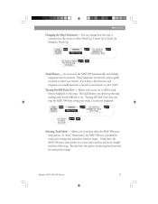
... some details difficult to select the desired Map Orientation ENTER NAV Track History - In "Auto" (Automatic), the MAP 330 uses a method for track point storage. Magellan MAP 330 GPS Receiver 31 You also have a record of your travels, or your track; If you drew a line between each waypoint you travel, the MAP 330 automatically saves hidden waypoints into its memory. Turning off...
... some details difficult to select the desired Map Orientation ENTER NAV Track History - In "Auto" (Automatic), the MAP 330 uses a method for track point storage. Magellan MAP 330 GPS Receiver 31 You also have a record of your travels, or your track; If you drew a line between each waypoint you travel, the MAP 330 automatically saves hidden waypoints into its memory. Turning off...
User Manual
Page 44
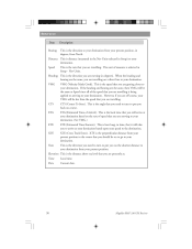
...land or marine use backtrack. From the MAP Screen MENU Highlight Clear Track ENTER Confirm ENTER Clearing Track - However, it very easy to view. The selection of the track points stored in the Map Setup option. Use this with caution. ENTER 32 Magellan MAP 330 GPS Receiver Selecting Land or Marine Use -... In the land mode, water is displayed as dark grey areas on the map and and land is how you ...
...land or marine use backtrack. From the MAP Screen MENU Highlight Clear Track ENTER Confirm ENTER Clearing Track - However, it very easy to view. The selection of the track points stored in the Map Setup option. Use this with caution. ENTER 32 Magellan MAP 330 GPS Receiver Selecting Land or Marine Use -... In the land mode, water is displayed as dark grey areas on the map and and land is how you ...
User Manual
Page 49
... for a third. DGPS Computed fixes are being tracked and position is being tracked and searching for any of the two fields. (See explanation of 13 data options (bearing, distance, speed, heading, VMG, CTS, ETA, ETE, XTE, turn, elevation, time, or date) for the fourth. Magellan MAP 330 GPS Receiver 37 Reference Customizing the Data Fields - Searching...
... for a third. DGPS Computed fixes are being tracked and position is being tracked and searching for any of the two fields. (See explanation of 13 data options (bearing, distance, speed, heading, VMG, CTS, ETA, ETE, XTE, turn, elevation, time, or date) for the fourth. Magellan MAP 330 GPS Receiver 37 Reference Customizing the Data Fields - Searching...
User Manual
Page 50
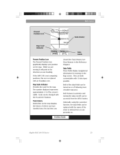
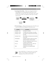
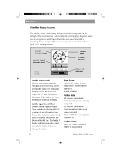
... Indicates the source of power being used and the strength of the bar indicates the relative signal strength; position computed is 2-dimensional (elevation is tracking satellites. Magellan MAP 330 GPS Receiver Satellite Position Graph Position Mode Satellite Position Satellite Signal Strength Chart Power Source Battery Life Indicator Satellite Position Graph The two circles indicate satellite...
... Indicates the source of power being used and the strength of the bar indicates the relative signal strength; position computed is 2-dimensional (elevation is tracking satellites. Magellan MAP 330 GPS Receiver Satellite Position Graph Position Mode Satellite Position Satellite Signal Strength Chart Power Source Battery Life Indicator Satellite Position Graph The two circles indicate satellite...
User Manual
Page 57
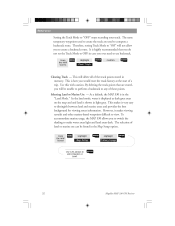
...ENTER Highlight Activate Backtrk ENTER Magellan MAP 330 GPS Receiver 45 Creating a Backtrack Route - When you turn your general vicinity (Nearest) or all of using track information stored in alphabetical order (Alphabetical). You can select only those waypoints in your MAP 330 off and then back on,... the GOTO route is follow the instructions below and let the MAP 330 take you just took. Creates a...
...ENTER Highlight Activate Backtrk ENTER Magellan MAP 330 GPS Receiver 45 Creating a Backtrack Route - When you turn your general vicinity (Nearest) or all of using track information stored in alphabetical order (Alphabetical). You can select only those waypoints in your MAP 330 off and then back on,... the GOTO route is follow the instructions below and let the MAP 330 take you just took. Creates a...
User Manual
Page 63
... MENU Highlight Setup ENTER Highlight Initialize ENTER Highlight Region ENTER Highlight Area ENTER Input Time ENTER Input Date ENTER ENTER Magellan MAP 330 GPS Receiver 51 This enables you to T01Pxx" where Pxx indicates the number of points in the route. From Any ...Screen MENU Highlight Routes ENTER Select Route MENU Highlight Map View Route ENTER Creating a Route Using Track History - Enables you with your track history. Two such instances would be travelling over 500 miles with a graphical representation of memory....
... MENU Highlight Setup ENTER Highlight Initialize ENTER Highlight Region ENTER Highlight Area ENTER Input Time ENTER Input Date ENTER ENTER Magellan MAP 330 GPS Receiver 51 This enables you to T01Pxx" where Pxx indicates the number of points in the route. From Any ...Screen MENU Highlight Routes ENTER Select Route MENU Highlight Map View Route ENTER Creating a Route Using Track History - Enables you with your track history. Two such instances would be travelling over 500 miles with a graphical representation of memory....
User Manual
Page 68
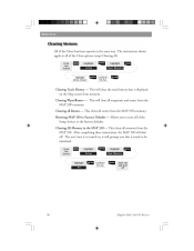
...Track History - This will clear the track history that it needs to the factory defaults. Allows you that is turned on the Map screen from the MAP 330's memory. This clears all waypoints and routes from memory. Clearing All Memory in the same way. Yes/No ENTER MAP 330 will shut off 56 Magellan MAP 330 GPS... Receiver Reference All of the Setup choices to be initialized. The next time it is displayed on , it will clear all memory from the MAP 330's memory. The instructions shown...
...Track History - This will clear the track history that it needs to the factory defaults. Allows you that is turned on the Map screen from the MAP 330's memory. This clears all waypoints and routes from memory. Clearing All Memory in the same way. Yes/No ENTER MAP 330 will shut off 56 Magellan MAP 330 GPS... Receiver Reference All of the Setup choices to be initialized. The next time it is displayed on , it will clear all memory from the MAP 330's memory. The instructions shown...
User Manual
Page 71
...activities knowing that the alarm will be sounded for the route you are navigating on. Setting the XTE Alarm - XTE or cross track errors happen when you are off course for the alarm. This option allows you to loss of the Alarm options are supposed ...Highlight Alarms/Msg ENTER Highlight Alarm Field ENTER Select Alarm Distance ENTER Setting the Arrival Alarm - Magellan MAP 330 GPS Receiver 59 Note: DoD applied Selective Availability errors can sound whenever the MAP 330 has lost its use would be travelling on or off the alarm that can considerably impact the...
...activities knowing that the alarm will be sounded for the route you are navigating on. Setting the XTE Alarm - XTE or cross track errors happen when you are off course for the alarm. This option allows you to loss of the Alarm options are supposed ...Highlight Alarms/Msg ENTER Highlight Alarm Field ENTER Select Alarm Distance ENTER Setting the Arrival Alarm - Magellan MAP 330 GPS Receiver 59 Note: DoD applied Selective Availability errors can sound whenever the MAP 330 has lost its use would be travelling on or off the alarm that can considerably impact the...
User Manual
Page 72
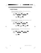
... Off - From Any Screen MENU Highlight Setup ENTER Highlight Simulate ENTER Highlight User ENTER Enter Heading and Speed Data ENTER Confirm Clearing of Track ENTER Turning on and uses a predefined heading and speed rate. This turns the simulator on the Simulator - This turns the simulator on... the Simulator - Turns the simulator off and returns the MAP 330 to normal operation. Auto Mode - User Mode - Reference Turning on and uses a heading and speed rate that you define. From Any Screen...
... Off - From Any Screen MENU Highlight Setup ENTER Highlight Simulate ENTER Highlight User ENTER Enter Heading and Speed Data ENTER Confirm Clearing of Track ENTER Turning on and uses a predefined heading and speed rate. This turns the simulator on the Simulator - This turns the simulator on... the Simulator - Turns the simulator off and returns the MAP 330 to normal operation. Auto Mode - User Mode - Reference Turning on and uses a heading and speed rate that you define. From Any Screen...
User Manual
Page 82
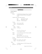
... feet (15 meters) RMS 0.1 knot RMS steady state approximately 15 seconds approximately 1 minute 1 second continuous Housing Temp. Appendix CHARACTERISTICS Performance Receiver 12 parallel-channel technology, tracks up to 12 satellites to 10 hours Magellan MAP 330 GPS Receiver
... feet (15 meters) RMS 0.1 knot RMS steady state approximately 15 seconds approximately 1 minute 1 second continuous Housing Temp. Appendix CHARACTERISTICS Performance Receiver 12 parallel-channel technology, tracks up to 12 satellites to 10 hours Magellan MAP 330 GPS Receiver
User Manual
Page 89
... left, of the destination. The north direction on most large and intermediate scale land topographic charts and maps. Cross Track Error. The perpendicular distance between the present position and the courseline. UTC UTM VMG WPT XTE Magellan MAP 330 GPS Receiver 77 Formerly referred to North Pole from an observer's position. Given as Greenwich Mean Time...
... left, of the destination. The north direction on most large and intermediate scale land topographic charts and maps. Cross Track Error. The perpendicular distance between the present position and the courseline. UTC UTM VMG WPT XTE Magellan MAP 330 GPS Receiver 77 Formerly referred to North Pole from an observer's position. Given as Greenwich Mean Time...
User Manual
Page 91
...; clearing all 56; customizing 35 Leg, appending 50; legend 27; street information 29 MapSend Streets™ 72 Map Object, saving 43; deleting 49; turning off track history display 31; track history 51 Magellan MAP 330 GPS Receiver 79 replacing 49 Map Screen 12, 24; clear WPT/routes 56; selecting 35; changing orientation 30; backtrack 45; inserting 49; clear...
...; clearing all 56; customizing 35 Leg, appending 50; legend 27; street information 29 MapSend Streets™ 72 Map Object, saving 43; deleting 49; turning off track history display 31; track history 51 Magellan MAP 330 GPS Receiver 79 replacing 49 Map Screen 12, 24; clear WPT/routes 56; selecting 35; changing orientation 30; backtrack 45; inserting 49; clear...
User Manual
Page 92
... 53 Time Format, selecting 53 Track History display 31; date changing 57; clearing 31, 56; turning on 60; preloaded 63; saving 15, 41; Appendix Satellite Status Screen 37 Setup 50 Signal Strength 37 Simulator 60; creating manually 41; deleting 45; appending to route 50 Wrist strap 4 80 Magellan MAP 330 GPS Receiver turning off 60;
... 53 Time Format, selecting 53 Track History display 31; date changing 57; clearing 31, 56; turning on 60; preloaded 63; saving 15, 41; Appendix Satellite Status Screen 37 Setup 50 Signal Strength 37 Simulator 60; creating manually 41; deleting 45; appending to route 50 Wrist strap 4 80 Magellan MAP 330 GPS Receiver turning off 60;
