Magellan MapSend Lakes USA - GPS Map Support and Manuals
Get Help and Manuals for this Magellan item
View All Support Options Below
Free Magellan MapSend Lakes USA manuals!
Problems with Magellan MapSend Lakes USA?
Ask a Question
Free Magellan MapSend Lakes USA manuals!
Problems with Magellan MapSend Lakes USA?
Ask a Question
Popular Magellan MapSend Lakes USA Manual Pages
Quick Reference Guide - Page 2

Note: Magellan MapSend Lite does not support the cutting and exporting of map regions. Maps loaded on the
PC using MapSend products are usable on SD cards (MapSend Topo Mexico,
Topo France, etc.)
° MapSend BlueNav Charts
° MapSend Lakes USA products
° Detailed MapSend maps that have been loaded in the Magellan eXplorist.
° Background maps preloaded in a Magellan ...
Quick Reference Guide - Page 3
... video card
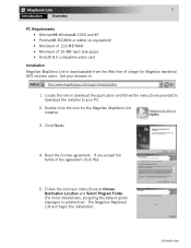
Installation Magellan MapSend Lite is satisfactory.) The Magellan MapSend Lite will begin the installation. Double click the icon for Magellan handheld GPS receiver users. Follow the onscreen instructions to :
http://www.magellangps.com/support/mapsendlite/
1. Click Next>
4. Locate the link to download the application and follow the instructions provided to download the installer to...
Quick Reference Guide - Page 4
...software verison for firmware updates.)
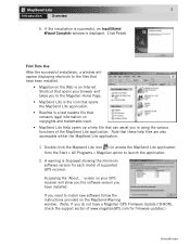
Introduction screen on the MapSend-Warning window. (Note: If you in using the various functions of supported GPS receiver. 3
Introduction
Overview
6.
If you have a Magellan GPS Firmware Update CD-ROM, check the support secton of www.magellanGPS.com for each model of the MapSend Lite application. First Time Use After the successful installation...
Quick Reference Guide - Page 6
4
Introduction
Overview
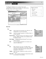
The Magellan MapSend Lite consists of the window.
Print Setup Displays standard Windows™ print setup options window. Overview Print...
Sends the image displayed ...Search Window 5
Search Window
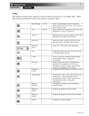
Menu Bar
File
Open
Opens data files from either your GPS Unit, SD Programmer or your PC hard drive. Print Preview Displays the map on the display as it will ...
Quick Reference Guide - Page 7
... the zoom cursor to a GPS receiver. Locate Used to convert data between selected points.
Legend When checked replaces the Search Window with street routes. (Note: this menu item is accessible only when a detail map has...and to quick find predefined land masses, active detail maps or specific geographic coordinates the user has set. Measure Distance Calculates the distance and area between...
Quick Reference Guide - Page 8
... Datum Used to select the north reference used with information on POI...Manual Displays a searchable user manual with the application (eXplorist or Meridian/SporTrak).
6
Introduction
Overview
Preferences
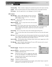
Window Size Locked When unchecked the Map Viewer window can be displayed for updates...Update Checks the Magellan web site for an item selected from the Map Viewer window.
GPS Settings...
Quick Reference Guide - Page 9
... Bar. Displays the Search window. Opens data files from either your GPS Unit, SD Programmer or your hard drive.
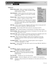
Displays the control center with topographic information.) Displays the...Waypoint Routes Control Center. Overview Map Manager Cntl+M
Open Zoom In
Cntl+O
Zoom Out
Set Map Scale Pan
Locate
3-D View
Elevation Profile
Street Routes
Measure Distance
Waypoint Viewer
Waypoint Routes...
Quick Reference Guide - Page 10
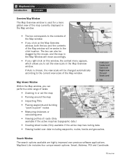
Overview Map Viewer Window
Within the Map window, you can also be changed automatically according to set the view scale in the Map Overview window. Search Window The search options available are highly improved over previous software applications.
MapSend Lite includes four unique search options: Smart, Address, POI and Coordinate.
8
Introduction
Overview
Overview Map...
Quick Reference Guide - Page 12
...Map Window. Displays a found object in the center of a house (if known). View Street - Set as an Intermediate Point of the Map Window.
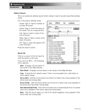
This is an advanced address search which allows to view ... in the list result to search by some specified address fields. ZIP: Type or insert the specific ZIP code (if known).
GoTo -
Street: Type or insert the name of a street route (only available...
Quick Reference Guide - Page 13
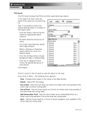
...Map Window. From the In category list-box choose the appropriate group of a desired radius. Set as Finish - Sets the found object as an Intermediate Point of the object you click on More... From the ...numbers in the list result to view the object on record in the object name. Click Search. Sets the found object as a Finish of a street route (only available if the active map has ...
Quick Reference Guide - Page 14
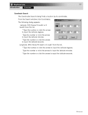
Longitude: W/E Choose W (west) or E (east) from the list. º Type the number or click the arrows to input the latitude ... " Type the number or click the arrows to input the latitude minutes. Overview The following dialog appears: Latitude: N/S Choose N (north) or S (south) from the list. º Type the number or click the arrows to input the latitude degrees. ' Type the number or click...
Quick Reference Guide - Page 1

... detailed street maps for specific navigation needs.
You can refer to the User Manual and get detailed answers to be used the same as any USA city and airport, along with many parks, lakes, streams, rivers, and dams. MapSend contains a wide assortment of built-in your questions about this software. MapSend Topo of MapSend are designed for route...
Quick Reference Guide - Page 2
... button. • In the Status box you have correctly installed the MapSend software. (Please refer to the back cover for a successful transfer of data to the back of the PC cable with the OK button. OR • Choose the required COM port (i.e. that is replaced with the DIN-9 connector to the connector, tighten it...
Quick Reference Guide - Page 6

... the file transfer. Follow the instructions in your PC.
- If...required communication options have been set.
- Estimated size of ... the size of the United States software.)
- When uploading regions, all...corresponding warning appears. Refer to the User Manual on downloading waypoints, tracks and routes from the ... to GPS...
-
Along with the MapSend Topo of marked regions by editing the...
Quick Reference Guide - Page 7

... to find a location by its address. Open the dialog to the current set of the window.
- Zoom in MapSend. -
Clicking the arrow provides the menu offering uploading/downloading of additional data. The toolbar provides quick mouse access to view the continental USA.
Choose a scale for the Map either from the View menu. Get help...
Magellan MapSend Lakes USA Reviews
We have not received any reviews for Magellan yet.