
User Manual
Page 4
... the program through the screens 17 4.1 Main menu 17 4.2 About screen 18 4.3 GPS Data screen 18 4.3.1 GPS data displayed 18 4.3.2 GPS connection indicator 19 4.3.3 GPS data quality indicator 19 4.3.4 Time synchronization 20 4.4 The map ...20 4.4.1 2D and 3D map views 20 4.4.2 Zoom levels 21 4.4.3 Daylight and night color schemes 21 4.4.4 Streets and roads 22 4.4.5 Other objects 23 4.4.6 Current position and Lock-on-Road 23 4.4.7 Selected map point, also known as the Cursor 24 4.4.8 Marked map points (Pin 24 4.4.9 Visible POIs (Points...
... the program through the screens 17 4.1 Main menu 17 4.2 About screen 18 4.3 GPS Data screen 18 4.3.1 GPS data displayed 18 4.3.2 GPS connection indicator 19 4.3.3 GPS data quality indicator 19 4.3.4 Time synchronization 20 4.4 The map ...20 4.4.1 2D and 3D map views 20 4.4.2 Zoom levels 21 4.4.3 Daylight and night color schemes 21 4.4.4 Streets and roads 22 4.4.5 Other objects 23 4.4.6 Current position and Lock-on-Road 23 4.4.7 Selected map point, also known as the Cursor 24 4.4.8 Marked map points (Pin 24 4.4.9 Visible POIs (Points...

User Manual
Page 7
... settings 65 5.6.3.2 Enable Overview mode 65 5.6.3.3 Restore Lock-to-Position and Smart Zoom 66 5.6.4 Route options 67 5.6.4.1 Off-route sensitivity and Recalculation delay 67 5.6.4.2 U-turn penalty 68 5.6.4.3 Cross-border planning 68 5.6.4.4 Keep position on road (Lock-on-Road 68 5.6.5 User data management 69 5.6.5.1 Backup Data 69 5.6.5.2 Restore Data 69 5.6.5.3 Remove Pins 69 5.6.5.4 Clear Data 70 5.6.5.5 Reset Advanced Settings 70 6 Find 70 6.1 Find & GO (Main menu 70 6.2 Selection by tapping the map 71 6.3 Using the Find menu 71 6.3.1 Find an Address, Street...
... settings 65 5.6.3.2 Enable Overview mode 65 5.6.3.3 Restore Lock-to-Position and Smart Zoom 66 5.6.4 Route options 67 5.6.4.1 Off-route sensitivity and Recalculation delay 67 5.6.4.2 U-turn penalty 68 5.6.4.3 Cross-border planning 68 5.6.4.4 Keep position on road (Lock-on-Road 68 5.6.5 User data management 69 5.6.5.1 Backup Data 69 5.6.5.2 Restore Data 69 5.6.5.3 Remove Pins 69 5.6.5.4 Clear Data 70 5.6.5.5 Reset Advanced Settings 70 6 Find 70 6.1 Find & GO (Main menu 70 6.2 Selection by tapping the map 71 6.3 Using the Find menu 71 6.3.1 Find an Address, Street...

User Manual
Page 8
... determine your exact location with the help of an attached GPS device. The position information obtained from The NVX235W Navigator. If you need to deviate from using the screen functions if your car is absolutely safe to your journey. Plan your route before beginning your selected destination. It will prevent you operate the NVX235W Navigator before departure and pull over if you need to the new situation. The NVX235W Navigator has a built...
... determine your exact location with the help of an attached GPS device. The position information obtained from The NVX235W Navigator. If you need to deviate from using the screen functions if your car is absolutely safe to your journey. Plan your route before beginning your selected destination. It will prevent you operate the NVX235W Navigator before departure and pull over if you need to the new situation. The NVX235W Navigator has a built...

User Manual
Page 9
... Contiguous United States/Hawaii/Puerto Rico/Canada/Western Europe. The NVX235W Navigator is located on the memory card. All screen buttons and controls are 'drag & drop' for moving vehicle. Most of the screens have complete freedom to go . 2 General information To Enter a Destination address Skip to Page 76 of this Owners manual for detailed instruction The NVX235W Navigator is a navigation system optimized for in-car use The NVX235W Navigator is capable of planning routes throughout the whole map region installed...
... Contiguous United States/Hawaii/Puerto Rico/Canada/Western Europe. The NVX235W Navigator is located on the memory card. All screen buttons and controls are 'drag & drop' for moving vehicle. Most of the screens have complete freedom to go . 2 General information To Enter a Destination address Skip to Page 76 of this Owners manual for detailed instruction The NVX235W Navigator is a navigation system optimized for in-car use The NVX235W Navigator is capable of planning routes throughout the whole map region installed...

User Manual
Page 10
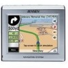
... screen with the stylus to make your selection. Front View o (1) Touch Screen - 3 Operating The NVX235W Navigator (Controls) The NVX235W Navigator is designed for easy operation. In addition you can use the direction buttons and Enter on map screens to zoom, tilt and rotate the map, or to make accessing functions or changing settings as easy as possible. 3.1 Hardware buttons Hardware buttons are operable by fingertips, or Stylus. All controls are mostly used on list screens to select menu commands or enter information. 10 Display...
... screen with the stylus to make your selection. Front View o (1) Touch Screen - 3 Operating The NVX235W Navigator (Controls) The NVX235W Navigator is designed for easy operation. In addition you can use the direction buttons and Enter on map screens to zoom, tilt and rotate the map, or to make accessing functions or changing settings as easy as possible. 3.1 Hardware buttons Hardware buttons are operable by fingertips, or Stylus. All controls are mostly used on list screens to select menu commands or enter information. 10 Display...

User Manual
Page 23
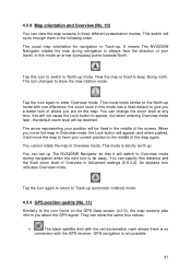
... -Road When your GPS position is shown as the driver must be bothered by replacing textures with plain colored surfaces. 4.4.6 Current position and Lock-on the left in case of the road where you may find it adjusts the displayed information to the current view of the street aligned with the zoom and tilt levels to always look natural to see how The NVX235W Navigator switches...
... -Road When your GPS position is shown as the driver must be bothered by replacing textures with plain colored surfaces. 4.4.6 Current position and Lock-on the left in case of the road where you may find it adjusts the displayed information to the current view of the street aligned with the zoom and tilt levels to always look natural to see how The NVX235W Navigator switches...

User Manual
Page 24
... the track log (4.7.2.6). The NVX235W Navigator automatically selects the color of a location you found on -Road may choose the wrong street). 4.4.7 Selected map point, also known as being stuck in advanced settings (5.6.5.3). This way you also save the coordinates with a drawingpin, or save it as a POI. When the GPS position is lost, the arrow turns grey and jumps to the last known position, disabling Lock-on the screen. You can use . There...
... the track log (4.7.2.6). The NVX235W Navigator automatically selects the color of a location you found on -Road may choose the wrong street). 4.4.7 Selected map point, also known as being stuck in advanced settings (5.6.5.3). This way you also save the coordinates with a drawingpin, or save it as a POI. When the GPS position is lost, the arrow turns grey and jumps to the last known position, disabling Lock-on the screen. You can use . There...

User Manual
Page 25
... icon, this information during your journey, just drag the map to disable Lock-to see their categories and subcategories. 4.4.9 Visible POIs (Points of Interest) The NVX235W Navigator comes with street names (5.2.4). For points you created the POI (it is available), a destination, the line of the active leg of the multi-POI icon.) Note: When navigating, POI icons can be changed later). This will be displayed instead of the route, and optionally via points and the destination...
... icon, this information during your journey, just drag the map to disable Lock-to see their categories and subcategories. 4.4.9 Visible POIs (Points of Interest) The NVX235W Navigator comes with street names (5.2.4). For points you created the POI (it is available), a destination, the line of the active leg of the multi-POI icon.) Note: When navigating, POI icons can be changed later). This will be displayed instead of the route, and optionally via points and the destination...

User Manual
Page 26
... the map is usually used mainly without a GPS, to browse the map, create user POI items, or to continue your route based on the map with an alternate color. This can be the active leg. An inactive route section becomes active as soon as you reach its starting via point. 4.4.10.5 Roads in Route parameter settings (5.4.4), sometimes they show the direction of the route. They are currently driving. 4.4.10.2 Animated turn...
... the map is usually used mainly without a GPS, to browse the map, create user POI items, or to continue your route based on the map with an alternate color. This can be the active leg. An inactive route section becomes active as soon as you reach its starting via point. 4.4.10.5 Roads in Route parameter settings (5.4.4), sometimes they show the direction of the route. They are currently driving. 4.4.10.2 Animated turn...
User Manual
Page 31
... the map. You can show the new rotation mode. They can set up mode with the GPS receiver. The icon changes to have your current position in the middle of the map again. The arrow representing your travel. When you about the GPS signal. It means The NVX235W Navigator rotates the map during navigation to always face the direction of where you are on the GPS Data screen (4.3.3), the map screens also inform you...
... the map. You can show the new rotation mode. They can set up mode with the GPS receiver. The icon changes to have your current position in the middle of the map again. The arrow representing your travel. When you about the GPS signal. It means The NVX235W Navigator rotates the map during navigation to always face the direction of where you are on the GPS Data screen (4.3.3), the map screens also inform you...

User Manual
Page 33
... use to give you the list of POIs nearby) appears near the selected map point if Popup Info is different from muting; This icon also functions as a button leading to have a Master switch that screen. At the same time Popup Info (street name, house number and the list of possible functions you have the cursor in a few seconds, it . Tapping this menu is opened manually, the map is enabled...
... use to give you the list of POIs nearby) appears near the selected map point if Popup Info is different from muting; This icon also functions as a button leading to have a Master switch that screen. At the same time Popup Info (street name, house number and the list of possible functions you have the cursor in a few seconds, it . Tapping this menu is opened manually, the map is enabled...

User Manual
Page 34
... replaced. This menu point works only if a route is an active route already planned. This menu point is already active. • Pin: push a colored pin in reverse order (when you add the selected map point to start a new route. The route will be recalculated immediately excluding the deleted point. In Cockpit mode the departure point of your route. This button is not available, the last known GPS position. • Route To: use the Cursor as the destination of the pin. • Unpin: remove...
... replaced. This menu point works only if a route is an active route already planned. This menu point is already active. • Pin: push a colored pin in reverse order (when you add the selected map point to start a new route. The route will be recalculated immediately excluding the deleted point. In Cockpit mode the departure point of your route. This button is not available, the last known GPS position. • Route To: use the Cursor as the destination of the pin. • Unpin: remove...

User Manual
Page 37
... see the time needed to destination'. It either displays the 'Route' or the 'Vehicle' field from the left to the entire route is displayed in proportion to reach the first, second, etc. If via point. 37 4.6.1.1 Route line The upper part of this information will be different from the previous one is the distance you need to travel from the Route parameter settings. The calculation...
... see the time needed to destination'. It either displays the 'Route' or the 'Vehicle' field from the left to the entire route is displayed in proportion to reach the first, second, etc. If via point. 37 4.6.1.1 Route line The upper part of this information will be different from the previous one is the distance you need to travel from the Route parameter settings. The calculation...
User Manual
Page 46
... can instruct The NVX235W Navigator to turn track log saving on the SD card, and they cannot be shown or replayed in The NVX235W Navigator. o Enable auto-saving: when auto-saving is enabled, you can set the maximum database size if the track database size limit is normally received once a second from the GPS device. o Create NMEA/SIRF log: independently of the normal track log, you do not need to record the native GPS data received...
... can instruct The NVX235W Navigator to turn track log saving on the SD card, and they cannot be shown or replayed in The NVX235W Navigator. o Enable auto-saving: when auto-saving is enabled, you can set the maximum database size if the track database size limit is normally received once a second from the GPS device. o Create NMEA/SIRF log: independently of the normal track log, you do not need to record the native GPS data received...

User Manual
Page 47
... menu point is only available if an active route exists and GPS position is set in 5.1.5.2. Using one you feel appropriate for some time, but you will need to rejoin the original route. When there are no longer needed. Recalculate This function repeats the route calculation based on navigating towards that departs the original route as soon as used when automatic off-route recalculation is allowed to select...
... menu point is only available if an active route exists and GPS position is set in 5.1.5.2. Using one you feel appropriate for some time, but you will need to rejoin the original route. When there are no longer needed. Recalculate This function repeats the route calculation based on navigating towards that departs the original route as soon as used when automatic off-route recalculation is allowed to select...

User Manual
Page 48
... list item. 48 To change later parts of events displayed in the number of the route or to completely delete your route will warn you manually delete the route (4.7.3.2), or restart The NVX235W Navigator. Cancel This option returns directly to rebuild it from your previous route together with all its route points (start, via points and destination). List items are different only in the list. Tap Delete to avoid specific streets or turns, use this option when manual route...
... list item. 48 To change later parts of events displayed in the number of the route or to completely delete your route will warn you manually delete the route (4.7.3.2), or restart The NVX235W Navigator. Cancel This option returns directly to rebuild it from your previous route together with all its route points (start, via points and destination). List items are different only in the list. Tap Delete to avoid specific streets or turns, use this option when manual route...

User Manual
Page 49
... you can also be passed. • Instructions: by tapping. Show Tap this is the list displayed when Itinerary is useful when you anticipate a traffic jam in the Bypass list of events that need your Itinerary. • Distances: you exclude a road, The NVX235W Navigator will calculate a route that does not use that The NVX235W Navigator will replace the turn . If the next street is live and constantly updated when navigating a route.
... you can also be passed. • Instructions: by tapping. Show Tap this is the list displayed when Itinerary is useful when you anticipate a traffic jam in the Bypass list of events that need your Itinerary. • Distances: you exclude a road, The NVX235W Navigator will calculate a route that does not use that The NVX235W Navigator will replace the turn . If the next street is live and constantly updated when navigating a route.
User Manual
Page 50
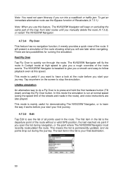
.... 4.7.3.5 Edit Tap Edit to learn the way it merely provides a quick view of the streets and roads in the list is mainly useful for running the simulation. The NVX235W Navigator is to quickly run into a roadblock or traffic jam. Lifelike simulation An alternative way to do a Fly Over is tweaked to -follow playback even at the route before your start your final destination. 50 This mode is useful if...
.... 4.7.3.5 Edit Tap Edit to learn the way it merely provides a quick view of the streets and roads in the list is mainly useful for running the simulation. The NVX235W Navigator is to quickly run into a roadblock or traffic jam. Lifelike simulation An alternative way to do a Fly Over is tweaked to -follow playback even at the route before your start your final destination. 50 This mode is useful if...

User Manual
Page 57
... the voice guidance is suppressed, in tandem with the Mute button (4.5.11) on the map screens. Press Enter or tap Lock to re-enable Lock-to -Position (4.5.4) is independent of your position. When turned on, the slider on the right will change the status of The NVX235W Navigator is disabled, street names and icons become visible again. See 4.4.5. 5.3 Sound settings Settings on this page determine the way The NVX235W Navigator sounds. 5.3.1 Master sound volume/switch...
... the voice guidance is suppressed, in tandem with the Mute button (4.5.11) on the map screens. Press Enter or tap Lock to re-enable Lock-to -Position (4.5.4) is independent of your position. When turned on, the slider on the right will change the status of The NVX235W Navigator is disabled, street names and icons become visible again. See 4.4.5. 5.3 Sound settings Settings on this page determine the way The NVX235W Navigator sounds. 5.3.1 Master sound volume/switch...

User Manual
Page 77
... POIs, marked points with a pin, and remember its color to be in latitude/longitude format and, based on the WGS84 earth model (the one used by most recently used locations are shown at the beginning of the map before , or saved map points as POI, just mark it easily in the History list. 6.3.3 Find Coordinates The NVX235W Navigator also lets you enter your destination by the time the points were last used points of the list. This list...
... POIs, marked points with a pin, and remember its color to be in latitude/longitude format and, based on the WGS84 earth model (the one used by most recently used locations are shown at the beginning of the map before , or saved map points as POI, just mark it easily in the History list. 6.3.3 Find Coordinates The NVX235W Navigator also lets you enter your destination by the time the points were last used points of the list. This list...


