Owner's Manual
Page 6
...which could affect the accuracy and performance of the product. GARMIN grants you a limited license to use a combination of GARMIN is to provide customers with the most complete and accurate ... normal operation of all data sources contain inaccurate or incomplete data to some degree. MAP DATA INFORMATION: One of the goals of governmental and private data sources, which is...displayed to the consumer. Although the eTrex Vista is either not available or prohibitively expensive. Virtually all GPS equipment. Software License Agreement BY USING THE ETREX VISTA, YOU AGREE TO BE BOUND BY ...
...which could affect the accuracy and performance of the product. GARMIN grants you a limited license to use a combination of GARMIN is to provide customers with the most complete and accurate ... normal operation of all data sources contain inaccurate or incomplete data to some degree. MAP DATA INFORMATION: One of the goals of governmental and private data sources, which is...displayed to the consumer. Although the eTrex Vista is either not available or prohibitively expensive. Virtually all GPS equipment. Software License Agreement BY USING THE ETREX VISTA, YOU AGREE TO BE BOUND BY ...
Owner's Manual
Page 10
... Installation 3 Backlighting and Contrast 3 The Main Pages Main Page Basics 4 Satellite The Main Page 5 Options 6-7 Navigating Navigating with eTrex Vista 8 Map The Main Page 9-10 Options 11-15 Using the Pan Map Option 12 Stop Navigation 13 Hide/Show Navigation Status 13 Hide/Show Data Fields 13 Setup 14-15 The Measure... .......38 Using a Goto 40 Routes Options 41-46 Creating and Using A Route 41 Editing a Route 42-44 Add/Edit from the Route Map Page ..44-45 Navigating a Route 45 Data Fields for the Route Page 46 Tracks Options 47-48 Setup Options 49-53 Time Page 49 ...
... Installation 3 Backlighting and Contrast 3 The Main Pages Main Page Basics 4 Satellite The Main Page 5 Options 6-7 Navigating Navigating with eTrex Vista 8 Map The Main Page 9-10 Options 11-15 Using the Pan Map Option 12 Stop Navigation 13 Hide/Show Navigation Status 13 Hide/Show Data Fields 13 Setup 14-15 The Measure... .......38 Using a Goto 40 Routes Options 41-46 Creating and Using A Route 41 Editing a Route 42-44 Add/Edit from the Route Map Page ..44-45 Navigating a Route 45 Data Fields for the Route Page 46 Tracks Options 47-48 Setup Options 49-53 Time Page 49 ...
Owner's Manual
Page 11
...eTrex Vista, adjusting the screen contrast, and basic navigation techniques to help you cannot receive a signal speeds unit map drawing and conserves battery power. See page 62 for 20 Routes with 50 Waypoints each . Route building capability, with storage capability for displaying a variety of detailed map data storage, allowing transfer from GARMIN... MapSource CD-ROM's. Currently, WAAS satellite signal reception requires an absolute clear view of the WAAS feature may not be able to receive or easily maintain a ...
...eTrex Vista, adjusting the screen contrast, and basic navigation techniques to help you cannot receive a signal speeds unit map drawing and conserves battery power. See page 62 for 20 Routes with 50 Waypoints each . Route building capability, with storage capability for displaying a variety of detailed map data storage, allowing transfer from GARMIN... MapSource CD-ROM's. Currently, WAAS satellite signal reception requires an absolute clear view of the WAAS feature may not be able to receive or easily maintain a ...
Owner's Manual
Page 12
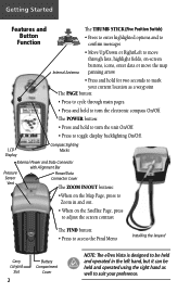
... adjust the screen contrast The FIND button: • Press to access the Find Menu Installing the lanyard Carry Lanyard Slot 2 Battery Compartment Cover NOTE: The eTrex Vista is designed to be held and operated in the left hand, but it can be held and operated using the right hand as well to... Marks External Power and Data Connector with Alignment Bar Pressure Power/Data Sensor Connector Cover Vent The ZOOM IN/OUT buttons: •When on the Map Page, press to Zoom in and out. • When on -screen buttons, icons, enter data or move the...
... adjust the screen contrast The FIND button: • Press to access the Find Menu Installing the lanyard Carry Lanyard Slot 2 Battery Compartment Cover NOTE: The eTrex Vista is designed to be held and operated in the left hand, but it can be held and operated using the right hand as well to... Marks External Power and Data Connector with Alignment Bar Pressure Power/Data Sensor Connector Cover Vent The ZOOM IN/OUT buttons: •When on the Map Page, press to Zoom in and out. • When on -screen buttons, icons, enter data or move the...
Owner's Manual
Page 14
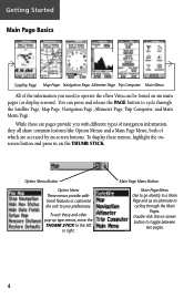
While these six pages provide you need to operate the eTrex Vista can press and release the PAGE button to cycle through the Main ... Page Menu Use to go directly to a Main Page and as an alternate to cycling through the Satellite Page, Map Page, Navigation Page, Altimeter Page, Trip Computer, and Main Menu Page. You can be found on the THUMB... STICK. Getting Started Main Page Basics Satellite Page Map Page Navigation Page Altimeter Page Trip Computer Main Menu All of the information you with different types of navigation information,...
While these six pages provide you need to operate the eTrex Vista can press and release the PAGE button to cycle through the Main ... Page Menu Use to go directly to a Main Page and as an alternate to cycling through the Satellite Page, Map Page, Navigation Page, Altimeter Page, Trip Computer, and Main Menu Page. You can be found on the THUMB... STICK. Getting Started Main Page Basics Satellite Page Map Page Navigation Page Altimeter Page Trip Computer Main Menu All of the information you with different types of navigation information,...
Owner's Manual
Page 16
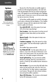
... your direction of travel through rocks, buildings, people, metal, or heavy tree cover so for faster map drawing). You can orient the satellite skyview by the GPS information received. New Location - GPS signals do not travel ) or 'North Up' (the satellite skyview oriented to provide you achieve navigational...the unit's view of the page & press in on the THUMB STICK. 6 Because the eTrex Vista relies on -screen button at the top of the sky determines how fast you with GPS Off - Select this mode. This gives the unit reference information and speeds satellite acquisition. Use...
... your direction of travel through rocks, buildings, people, metal, or heavy tree cover so for faster map drawing). You can orient the satellite skyview by the GPS information received. New Location - GPS signals do not travel ) or 'North Up' (the satellite skyview oriented to provide you achieve navigational...the unit's view of the page & press in on the THUMB STICK. 6 Because the eTrex Vista relies on -screen button at the top of the sky determines how fast you with GPS Off - Select this mode. This gives the unit reference information and speeds satellite acquisition. Use...
Owner's Manual
Page 17
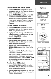
... enter a new location: 1. If you choose 'Auto' the eTrex Vista determines your approximate location and press ENTER". Use the THUMB STICK to highlight the Option Menu button at the top of the page and then press it in on GPS information. If you choose 'Use Map' a map page displays with instructions stating, "Point to display...
... enter a new location: 1. If you choose 'Auto' the eTrex Vista determines your approximate location and press ENTER". Use the THUMB STICK to highlight the Option Menu button at the top of the page and then press it in on GPS information. If you choose 'Use Map' a map page displays with instructions stating, "Point to display...
Owner's Manual
Page 18
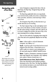
... the unit turned on the same path using the eTrex Vista and each is supported by the 'Pointer Icon' and a dotted line indicating your starting point on and receiving satellites. 8 Goto - A previous path of the six Main Pages: the Map Page, Navigation Page and Trip Computer Page. A ... (logged) in the eTrex Vista. The Map Page displays your speed, the time spent moving or stopped, and other options can be chosen to a destination consisting of intermediate stops along the way (waypoints, cities, highway exits, points of navigating when using the GARMIN TracBack feature. The Trip...
... the unit turned on the same path using the eTrex Vista and each is supported by the 'Pointer Icon' and a dotted line indicating your starting point on and receiving satellites. 8 Goto - A previous path of the six Main Pages: the Map Page, Navigation Page and Trip Computer Page. A ... (logged) in the eTrex Vista. The Map Page displays your speed, the time spent moving or stopped, and other options can be chosen to a destination consisting of intermediate stops along the way (waypoints, cities, highway exits, points of navigating when using the GARMIN TracBack feature. The Trip...
Owner's Manual
Page 19
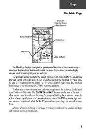
... because GARMIN MapSource data has been downloaded to 500 miles. A Status Window at the top of the page provides you to view the map from different perspectives, the scale can be changed from 120 feet to the unit using a triangular 'Position Icon' that is centered on the map. Pressing... and direction of detail than the basemap provided with current satellite tracking and position accuracy information. 9 The map shown above displays a higher level of movement using a CD-ROM mapping program. The ZOOM IN and OUT buttons on the side of changing in increments. To allow you a...
... because GARMIN MapSource data has been downloaded to 500 miles. A Status Window at the top of the page provides you to view the map from different perspectives, the scale can be changed from 120 feet to the unit using a triangular 'Position Icon' that is centered on the map. Pressing... and direction of detail than the basemap provided with current satellite tracking and position accuracy information. 9 The map shown above displays a higher level of movement using a CD-ROM mapping program. The ZOOM IN and OUT buttons on the side of changing in increments. To allow you a...
Owner's Manual
Page 20
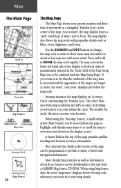
... defining your location. In many instances the map displays an 'Accuracy Circle' surrounding the 'Position Icon'. The eTrex Vista uses both map resolution and GPS accuracy in order to show more map area with less detail or less map area with the Map Setup Page). As you travel and navigation information. Press.... A Status Field at the bottom of the page can be programmed to the unit from a GARMIN MapSource CD-ROM. If you zoom in to view areas not shown on the display screen. More detailed map features as well as lakes, rivers, highways, and towns. When using the 'Pan...
... defining your location. In many instances the map displays an 'Accuracy Circle' surrounding the 'Position Icon'. The eTrex Vista uses both map resolution and GPS accuracy in order to show more map area with less detail or less map area with the Map Setup Page). As you travel and navigation information. Press.... A Status Field at the bottom of the page can be programmed to the unit from a GARMIN MapSource CD-ROM. If you zoom in to view areas not shown on the display screen. More detailed map features as well as lakes, rivers, highways, and towns. When using the 'Pan...
Owner's Manual
Page 21
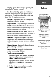
...' displays. Hide Nav Status/Show Nav Status - Displays the distance from one point on the THUMB STICK to your eTrex Vista. Options On-screen Map Page Options Menu button Map Page Options Menu with 'Pan Map' selected. Many are replaced by the 'Hide Data Fields' option. Removes the navigation status window to the original factory...
...' displays. Hide Nav Status/Show Nav Status - Displays the distance from one point on the THUMB STICK to your eTrex Vista. Options On-screen Map Page Options Menu button Map Page Options Menu with 'Pan Map' selected. Many are replaced by the 'Hide Data Fields' option. Removes the navigation status window to the original factory...
Owner's Manual
Page 22
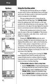
... moves to as a waypoint, or view the sun and moon phase from the Options Menu on the map page. An Options Menu allows you to Goto the map item, display it on a map item, the name of that is activated from it. When using the panning arrow, pressing the FIND button displays... items with Panning Arrow Highlighted Map Item Map Item Information 12 Using the Pan Map option The Map Page pan function allows you want to the Map Page. When the item's name is highlighted. Whenever the panning arrow is placed on the...
... moves to as a waypoint, or view the sun and moon phase from the Options Menu on the map page. An Options Menu allows you to Goto the map item, display it on a map item, the name of that is activated from it. When using the panning arrow, pressing the FIND button displays... items with Panning Arrow Highlighted Map Item Map Item Information 12 Using the Pan Map option The Map Page pan function allows you want to the Map Page. When the item's name is highlighted. Whenever the panning arrow is placed on the...
Owner's Manual
Page 23
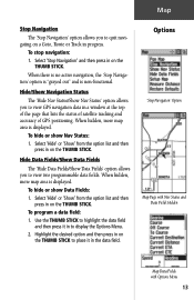
...option list and then press in on the THUMB STICK to view GPS navigation data in to display the Options Menu. 2. To program a data field: 1. Options 'Stop Navigation' Option Map Page with Nav Status and Data Fields Hidden Map Data Fields with Options Menu 13 Hide/Show Navigation Status The '... Use the THUMB STICK to highlight the data field and then press it in on the THUMB STICK. When hidden, more map area is displayed. When hidden, more map area is displayed. Select 'Hide' or 'Show' from the option list and then press in the data field. To ...
...option list and then press in on the THUMB STICK to view GPS navigation data in to display the Options Menu. 2. To program a data field: 1. Options 'Stop Navigation' Option Map Page with Nav Status and Data Fields Hidden Map Data Fields with Options Menu 13 Hide/Show Navigation Status The '... Use the THUMB STICK to highlight the data field and then press it in on the THUMB STICK. When hidden, more map area is displayed. When hidden, more map area is displayed. Select 'Hide' or 'Show' from the option list and then press in the data field. To ...
Owner's Manual
Page 24
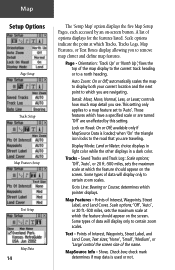
... displays in light color while the other displays in a dark color. Tracks - determines which the feature should appear on the screen. Some types of the map display to the current track heading or to 'Auto'. Points of Interest, Waypoints, Street Label, and Land Cover, Text sizes; 'None', 'Small', '... scales. Saved Tracks and Track Log: Scale options; 'Off', 'Auto', or 20 ft.-500 miles, sets the maximum scale at which pointer displays. Map Features - Points of data will display only to which the feature should appear on the screen. Detail: Most, More, Normal, Less, or Least;...
... displays in light color while the other displays in a dark color. Tracks - determines which the feature should appear on the screen. Some types of the map display to the current track heading or to 'Auto'. Points of Interest, Waypoints, Street Label, and Land Cover, Text sizes; 'None', 'Small', '... scales. Saved Tracks and Track Log: Scale options; 'Off', 'Auto', or 20 ft.-500 miles, sets the maximum scale at which pointer displays. Map Features - Points of data will display only to which the feature should appear on the screen. Detail: Most, More, Normal, Less, or Least;...
Owner's Manual
Page 25
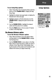
... point to display the options list for that feature. 4. Press the PAGE button or the on the THUMB STICK to which you began measuring. A new 'Map Pointer' field displays showing the location of the pointer and the direction and distance from the Options Menu and then press in on -screen... STICK to highlight the desired option and then press it in on the THUMB STICK to the Map Page. Select 'Setup Map' from the Options Menu and then press in to display the Map Setup Page. 2. Map To use the Measure Distance option: 1. Highlight a feature on the list and press in on the ...
... point to display the options list for that feature. 4. Press the PAGE button or the on the THUMB STICK to which you began measuring. A new 'Map Pointer' field displays showing the location of the pointer and the direction and distance from the Options Menu and then press in on -screen... STICK to highlight the desired option and then press it in on the THUMB STICK to the Map Page. Select 'Setup Map' from the Options Menu and then press in to display the Map Setup Page. 2. Map To use the Measure Distance option: 1. Highlight a feature on the list and press in on the ...
Owner's Manual
Page 28
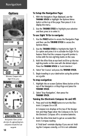
...then press in to select it in to display the menu. 2. Hold the eTrex Vista at eye level and line up the two sighting marks on -screen Options Menu button at the top of the Navigation or Map Page and press the THUMB STICK. 2. To stop navigation: 1. Turning the Electronic... On or Off. Select 'Stop Navigation', then press the THUMB STICK. A Compass Icon displays at the top of the Navigation and Map Pages when the Compass is not calibrated. Turn the Electronic Compass off to get an accurate Electronic Compass reading. Hold the eTrex Vista level to conserve batteries. 2.
...then press in to select it in to display the menu. 2. Hold the eTrex Vista at eye level and line up the two sighting marks on -screen Options Menu button at the top of the Navigation or Map Page and press the THUMB STICK. 2. To stop navigation: 1. Turning the Electronic... On or Off. Select 'Stop Navigation', then press the THUMB STICK. A Compass Icon displays at the top of the Navigation and Map Pages when the Compass is not calibrated. Turn the Electronic Compass off to get an accurate Electronic Compass reading. Hold the eTrex Vista level to conserve batteries. 2.
Owner's Manual
Page 29
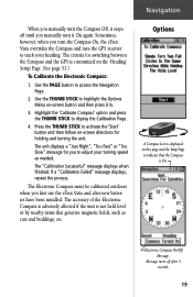
..., it stays off after new batteries have been installed. Message turns off until you manually turn the Compass On, the eTrex Vista overrides the Compass and uses the GPS receiver to display the Calibration Page. 4. Press the THUMB STICK to activate the 'Start' button and then follow on this ...page and the Map Page to highlight the Options Menu on the 'Heading' Setup Page. (See page 51.) To Calibrate the Electronic Compass: 1. If ...
..., it stays off after new batteries have been installed. Message turns off until you manually turn the Compass On, the eTrex Vista overrides the Compass and uses the GPS receiver to display the Calibration Page. 4. Press the THUMB STICK to activate the 'Start' button and then follow on this ...page and the Map Page to highlight the Options Menu on the 'Heading' Setup Page. (See page 51.) To Calibrate the Electronic Compass: 1. If ...
Owner's Manual
Page 35
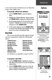
... option and then press in the data field. Data Fields The two user-selectable data fields support this page and can obtain from a map or other reliable source. To program a data field: 1. Navigation Page Data Fields Options 25 On the number keyboard, use the THUMB STICK to enter...
... option and then press in the data field. Data Fields The two user-selectable data fields support this page and can obtain from a map or other reliable source. To program a data field: 1. Navigation Page Data Fields Options 25 On the number keyboard, use the THUMB STICK to enter...
Owner's Manual
Page 38
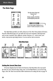
...; find map items such as cities, interstate exits, addresses, points of interest, etc.; Main Menu Pages Setting the Correct Time Zone If the time displayed in on page 49. 28 To exit these pages, highlight the onscreen 'X' button and press in the field at the bottom of the eTrex Vista's advanced...
...; find map items such as cities, interstate exits, addresses, points of interest, etc.; Main Menu Pages Setting the Correct Time Zone If the time displayed in on page 49. 28 To exit these pages, highlight the onscreen 'X' button and press in the field at the bottom of the eTrex Vista's advanced...
Owner's Manual
Page 39
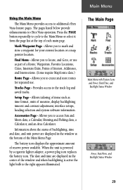
... and an Area Calculator. Find Menu - Waypoints, Favorite Locations, Cities, Interstate Exits, Points of reserve power available. Provides access to additional eTrex Vista feature pages. Allows you to the Main Menu or select it from the page list at the bottom of a Route; The date and ...page. Tracks Page - Setup Page - The pages listed below provide enhancements to create and store routes for your current location or a map pointer location. Allows tailoring of items such as part of the Main Menu Page. Mark Waypoint Page - Information about the status of ...
... and an Area Calculator. Find Menu - Waypoints, Favorite Locations, Cities, Interstate Exits, Points of reserve power available. Provides access to additional eTrex Vista feature pages. Allows you to the Main Menu or select it from the page list at the bottom of a Route; The date and ...page. Tracks Page - Setup Page - The pages listed below provide enhancements to create and store routes for your current location or a map pointer location. Allows tailoring of items such as part of the Main Menu Page. Mark Waypoint Page - Information about the status of ...


