Important Safety and Product Information
Page 2
... limits when operating in the United States, you are not followed, batteries may experience a shortened life span or may not cause interference, and (2) this device must not be used for any discrepancies before attempting such operations. • When navigating, carefully compare information displayed on -road navigation. • Always use . Repairs should become distracted by an authorized Garmin service center. Garmin makes no guarantee that has been connected to a replacement or...
... limits when operating in the United States, you are not followed, batteries may experience a shortened life span or may not cause interference, and (2) this device must not be used for any discrepancies before attempting such operations. • When navigating, carefully compare information displayed on -road navigation. • Always use . Repairs should become distracted by an authorized Garmin service center. Garmin makes no guarantee that has been connected to a replacement or...
Owners Manual
Page 3
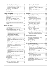
... Vehicle 3 Mounting and Powering the dēzl OTR710 / LGV710 Device in Your Vehicle 5 Turning the Device On or Off 7 Acquiring GPS Signals 8 Status Bar Icons 8 Using the On-Screen Buttons 8 Adjusting the Volume 9 Using the Audio Mixer 9 Adjusting the Screen Brightness 9 Vehicle Profiles 9 Adding a Vehicle Profile 9 Car Profile 9 Switching the Vehicle Profile 10 Changing Your Trailer Information...... 10 Editing a Vehicle Profile 10 Driver Awareness Features and Alerts 11 Enabling or Disabling Driver Alerts.......11 Red Light and Speed Cameras 12 Finding and Saving Locations...
... Vehicle 3 Mounting and Powering the dēzl OTR710 / LGV710 Device in Your Vehicle 5 Turning the Device On or Off 7 Acquiring GPS Signals 8 Status Bar Icons 8 Using the On-Screen Buttons 8 Adjusting the Volume 9 Using the Audio Mixer 9 Adjusting the Screen Brightness 9 Vehicle Profiles 9 Adding a Vehicle Profile 9 Car Profile 9 Switching the Vehicle Profile 10 Changing Your Trailer Information...... 10 Editing a Vehicle Profile 10 Driver Awareness Features and Alerts 11 Enabling or Disabling Driver Alerts.......11 Red Light and Speed Cameras 12 Finding and Saving Locations...
Owners Manual
Page 4
... Disabling Bluetooth Features (iPhone 34 Bluetooth Feature Status Icons 34 Traffic 38 Receiving Traffic Data Using Your Smartphone 38 Receiving Traffic Data Using a Traffic Receiver 38 Traffic Receiver Subscriptions......... 38 Enabling Traffic 39 Viewing Traffic on the Map 39 Searching for Traffic Incidents......... 39 Vehicle and Driver Tools 39 Break Planning 39 Taking a Suggested Break 39 Starting the Break Timer 40 Pausing and Resetting the Break Timer 40 Adjusting Drive Hours 40 Adjusting the Daily Driving Limit...... 40 Garmin eLog 40 Setting Up Garmin...
... Disabling Bluetooth Features (iPhone 34 Bluetooth Feature Status Icons 34 Traffic 38 Receiving Traffic Data Using Your Smartphone 38 Receiving Traffic Data Using a Traffic Receiver 38 Traffic Receiver Subscriptions......... 38 Enabling Traffic 39 Viewing Traffic on the Map 39 Searching for Traffic Incidents......... 39 Vehicle and Driver Tools 39 Break Planning 39 Taking a Suggested Break 39 Starting the Break Timer 40 Pausing and Resetting the Break Timer 40 Adjusting Drive Hours 40 Adjusting the Daily Driving Limit...... 40 Garmin eLog 40 Setting Up Garmin...
Owners Manual
Page 5
...Calculation Mode Settings 53 Setting a Simulated Location........... 53 Wireless Network Settings 54 Driver Assistance Settings 54 Proximity Alerts Settings 54 Backup Camera Settings 54 Display Settings 55 Traffic Settings 55 Units and Time Settings 55 Setting the Time 55 Language and Keyboard Settings........ 55 Device and Privacy Settings 55 Resetting Data and Settings 56 Device Information 56 Viewing E-label Regulatory and Compliance Information 56 Specifications 56 Charging the Device 56 Device Maintenance 56 Garmin Support Center 56 Map and Software Updates 57 Connecting...
...Calculation Mode Settings 53 Setting a Simulated Location........... 53 Wireless Network Settings 54 Driver Assistance Settings 54 Proximity Alerts Settings 54 Backup Camera Settings 54 Display Settings 55 Traffic Settings 55 Units and Time Settings 55 Setting the Time 55 Language and Keyboard Settings........ 55 Device and Privacy Settings 55 Resetting Data and Settings 56 Device Information 56 Viewing E-label Regulatory and Compliance Information 56 Specifications 56 Charging the Device 56 Device Maintenance 56 Garmin Support Center 56 Map and Software Updates 57 Connecting...
Owners Manual
Page 14
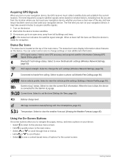
.... Select to hands-free calling. Using the On-Screen Buttons On-screen buttons allow you to navigate the pages, menus, and menu options on your navigation device, the GPS receiver must collect satellite data and establish the current location. Connected to place a phone call (Hands-Free Calling, page 36). Active vehicle profile. dēzl app connection status(Pairing with Your Smartphone, page 33). The time required to acquire satellite signals varies based on several minutes to acquire satellite signals. 1 Turn...
.... Select to hands-free calling. Using the On-Screen Buttons On-screen buttons allow you to navigate the pages, menus, and menu options on your navigation device, the GPS receiver must collect satellite data and establish the current location. Connected to place a phone call (Hands-Free Calling, page 36). Active vehicle profile. dēzl app connection status(Pairing with Your Smartphone, page 33). The time required to acquire satellite signals varies based on several minutes to acquire satellite signals. 1 Turn...
Owners Manual
Page 17
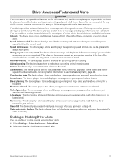
.... Driver Awareness Features and Alerts 11 Your device provides features that may be receiving traffic information to use safe driving judgment at all alerts are available in a familiar area. Speed limit exceeded: The device displays a red border on a one -way street or correct your direction of travel. Speed limit reduced: The device plays a tone and displays the upcoming speed limit so you exceed the posted speed limit for some types of a state...
.... Driver Awareness Features and Alerts 11 Your device provides features that may be receiving traffic information to use safe driving judgment at all alerts are available in a familiar area. Speed limit exceeded: The device displays a red border on a one -way street or correct your direction of travel. Speed limit reduced: The device plays a tone and displays the upcoming speed limit so you exceed the posted speed limit for some types of a state...
Owners Manual
Page 18
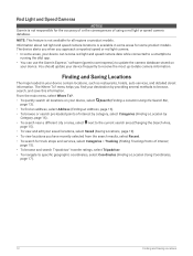
... some product models. Finding and Saving Locations The maps loaded in some areas for some areas, your device can receive red light and speed camera data while connected to a smartphone running the dēzl app. • You can use the Garmin Express™ software (garmin.com/express) to update the camera database stored on your device, select Search (Finding a Location Using the Search Bar, page 13). • To find your destination by...
... some product models. Finding and Saving Locations The maps loaded in some areas for some areas, your device can receive red light and speed camera data while connected to a smartphone running the dēzl app. • You can use the Garmin Express™ software (garmin.com/express) to update the camera database stored on your device, select Search (Finding a Location Using the Search Bar, page 13). • To find your destination by...
Owners Manual
Page 27
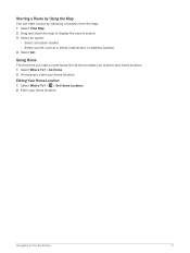
... your home location. 1 Select Where To? > Go Home. 2 If necessary, enter your home location. Going Home The first time you to Your Destination 21 Editing Your Home Location 1 Select Where To? > > Set Home Location. 2 Enter your home location. Starting a Route by Using the Map You can start a route home, the device prompts you start a route by selecting a location from the map. 1 Select View Map. 2 Drag and zoom the map to display the area to search. 3 Select an option: • Select a location marker. • Select a point, such as a street, intersection, or address location...
... your home location. 1 Select Where To? > Go Home. 2 If necessary, enter your home location. Going Home The first time you to Your Destination 21 Editing Your Home Location 1 Select Where To? > > Set Home Location. 2 Enter your home location. Starting a Route by Using the Map You can start a route home, the device prompts you start a route by selecting a location from the map. 1 Select View Map. 2 Drag and zoom the map to display the area to search. 3 Select an option: • Select a location marker. • Select a point, such as a street, intersection, or address location...
Owners Manual
Page 28
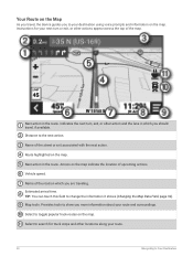
... your destination using voice prompts and information on the map. Name of the map. Vehicle speed. Estimated arrival time. Map tools. Select to your route and surroundings. Distance to show you are traveling. Provides tools to the next action. Next action in the route. TIP: You can touch this field to Your Destination Next action in the route. Instructions for truck stops and other locations along your next turn...
... your destination using voice prompts and information on the map. Name of the map. Vehicle speed. Estimated arrival time. Map tools. Select to your route and surroundings. Distance to show you are traveling. Provides tools to the next action. Next action in the route. TIP: You can touch this field to Your Destination Next action in the route. Instructions for truck stops and other locations along your next turn...
Owners Manual
Page 31
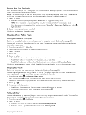
... Truck Parking, page 18). 1 Select an option: • When the device suggests parking, select More to see all suggested parking area, the device automatically updates your route or detour around a specific road on the map. • To remove a shaping point, select the shaping point and select . While using the car vehicle profile. Navigating to Your Destination 25 Parking Near Your Destination Your device can help you to the destinations in order. This is...
... Truck Parking, page 18). 1 Select an option: • When the device suggests parking, select More to see all suggested parking area, the device automatically updates your route or detour around a specific road on the map. • To remove a shaping point, select the shaping point and select . While using the car vehicle profile. Navigating to Your Destination 25 Parking Near Your Destination Your device can help you to the destinations in order. This is...
Owners Manual
Page 34
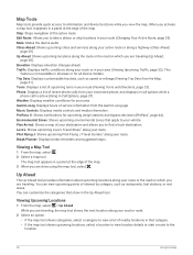
..., such as speed or mileage (Viewing Trip Data from the Garmin eLog app. Edit Route: Allows you are done using the map tool, select . Up Ahead: Shows upcoming locations along a highway (Cities Ahead, page 29). Phone: Displays a list of the map. Music Controls: Displays media controls and media information. The map tool appears in a panel at the edge of service information from the Map, page 31). You can view upcoming points of the active route.
..., such as speed or mileage (Viewing Trip Data from the Garmin eLog app. Edit Route: Allows you are done using the map tool, select . Up Ahead: Shows upcoming locations along a highway (Cities Ahead, page 29). Phone: Displays a list of the map. Music Controls: Displays media controls and media information. The map tool appears in a panel at the edge of service information from the Map, page 31). You can view upcoming points of the active route.
Owners Manual
Page 39
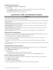
.... 2 Turn on -screen instructions to your phone. Live Services, Traffic, and Smartphone Features 33 Hands-Free calling: Allows you to enable additional features and access live traffic data and weather information. You can pair your dēzl device with Your Smartphone You can disable specific Bluetooth features and remain connected to the other . 3 On your smartphone apps appears. 3 Select the toggle switch next to an app to place and receive phone calls using your device (Viewing the...
.... 2 Turn on -screen instructions to your phone. Live Services, Traffic, and Smartphone Features 33 Hands-Free calling: Allows you to enable additional features and access live traffic data and weather information. You can pair your dēzl device with Your Smartphone You can disable specific Bluetooth features and remain connected to the other . 3 On your smartphone apps appears. 3 Select the toggle switch next to an app to place and receive phone calls using your device (Viewing the...

Owners Manual
Page 42
... number, street name, city, and state. • To search for a business name, enter all or part of interest. 3 Select > Call. The dēzl device starts navigating to the selected location, and the location is loaded from your phone to your recent searches in the Where To? Placing a Call Using Voice Dial 1 Select > Phone > Voice Dial. 2 Listen for a city, enter the city and state. to start a route. menu. Using Bluetooth wireless technology, your device can place or receive calls using your device...
... number, street name, city, and state. • To search for a business name, enter all or part of interest. 3 Select > Call. The dēzl device starts navigating to the selected location, and the location is loaded from your phone to your recent searches in the Where To? Placing a Call Using Voice Dial 1 Select > Phone > Voice Dial. 2 Listen for a city, enter the city and state. to start a route. menu. Using Bluetooth wireless technology, your device can place or receive calls using your device...
Owners Manual
Page 44
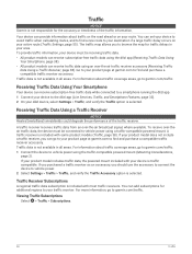
...be connected to vehicle power. 2 Select Settings > Traffic > Traffic, and verify the Traffic Accessory option is selected. You can receive traffic data using an over-the-air traffic receiver accessory (Receiving Traffic Data Using a Traffic Receiver, page 38). Traffic NOTICE Garmin is included with most traffic receivers. The traffic map allows you to your device to vehicle power using a traffic-compatible powered mount. Receiving Traffic Data Using Your Smartphone Your device can provide information about traffic coverage areas, go to your active route (Traffic Settings, page...
...be connected to vehicle power. 2 Select Settings > Traffic > Traffic, and verify the Traffic Accessory option is selected. You can receive traffic data using an over-the-air traffic receiver accessory (Receiving Traffic Data Using a Traffic Receiver, page 38). Traffic NOTICE Garmin is included with most traffic receivers. The traffic map allows you to your device to vehicle power using a traffic-compatible powered mount. Receiving Traffic Data Using Your Smartphone Your device can provide information about traffic coverage areas, go to your active route (Traffic Settings, page...
Owners Manual
Page 46
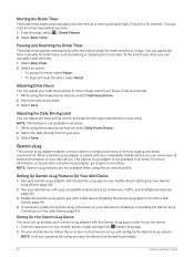
... driven. 3 Select Save. When a Garmin eLog adapter is paired with the Garmin eLog app in your dēzl device. Adjusting the Daily Driving Limit You can view hours of your drive, you complete the setup process, the device has limited functionality. 40 Vehicle and Driver Tools Setting Up Garmin eLog Features On Your dēzl Device 1 Pair your Garmin eLog adapter with the Garmin eLog app on -screen instructions to correspond...
... driven. 3 Select Save. When a Garmin eLog adapter is paired with the Garmin eLog app in your dēzl device. Adjusting the Daily Driving Limit You can view hours of your drive, you complete the setup process, the device has limited functionality. 40 Vehicle and Driver Tools Setting Up Garmin eLog Features On Your dēzl Device 1 Pair your Garmin eLog adapter with the Garmin eLog app on -screen instructions to correspond...
Owners Manual
Page 58
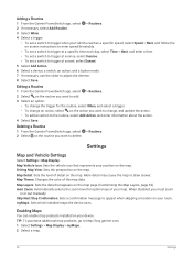
... routine, select Add Action, and enter information about the action. 4 Select Save. Map Theme: Changes the color of detail on the map page (Customizing the Map Layers, page 32). When disabled, you want to change an action, select on -screen instructions to enter speed thresholds. • To set a switch to trigger at a specific time each day, select Time > Next, and enter a time. • To set a switch to trigger at sunset, select Sunset. 5 Select Add Action. 6 Select a device, a switch, an action, and a button mode. 7 If necessary, use of...
... routine, select Add Action, and enter information about the action. 4 Select Save. Map Theme: Changes the color of detail on the map page (Customizing the Map Layers, page 32). When disabled, you want to change an action, select on -screen instructions to enter speed thresholds. • To set a switch to trigger at a specific time each day, select Time > Next, and enter a time. • To set a switch to trigger at sunset, select Sunset. 5 Select Add Action. 6 Select a device, a switch, an action, and a button mode. 7 If necessary, use of...
Owners Manual
Page 61
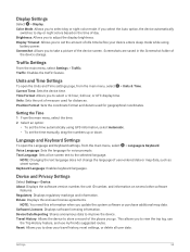
... display time. Screenshots are saved in the Screenshot folder of user-entered data or map data, such as street names. Time Format: Allows you to select day or night color mode. NOTE: Changing the text language does not change the language of the device storage. NOTE: You need this information when you to view the trip log, use the Trip History feature, and use myTrends suggested routes. Screenshot: Allows you go. Current Time: Sets the device time. Position Format: Sets the coordinate format and datum used for distances. Keyboard Language: Enables...
... display time. Screenshots are saved in the Screenshot folder of user-entered data or map data, such as street names. Time Format: Allows you to select day or night color mode. NOTE: Changing the text language does not change the language of the device storage. NOTE: You need this information when you to view the trip log, use the Trip History feature, and use myTrends suggested routes. Screenshot: Allows you go. Current Time: Sets the device time. Position Format: Sets the coordinate format and datum used for distances. Keyboard Language: Enables...
Owners Manual
Page 62
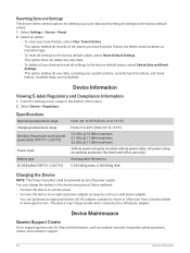
It does not delete saved locations or installed maps. • To reset all settings to the factory default values, select Delete Data and Reset Settings. This option does not delete any of these methods. • Connect the device to vehicle power. • Connect the device to an optional power adapter accessory, such as product manuals, frequently asked questions, videos, and customer support. 56 Device Information This option deletes all user data, including your travel history. Specifications Operating temperature range Charging temperature range Wireless frequencies...
It does not delete saved locations or installed maps. • To reset all settings to the factory default values, select Delete Data and Reset Settings. This option does not delete any of these methods. • Connect the device to vehicle power. • Connect the device to an optional power adapter accessory, such as product manuals, frequently asked questions, videos, and customer support. 56 Device Information This option deletes all user data, including your travel history. Specifications Operating temperature range Charging temperature range Wireless frequencies...
Owners Manual
Page 68
... can result in damage to my phone • Select > Wireless Networks > Bluetooth. My device is not acquiring satellite signals • Verify the GPS simulator is turned off the wi-fi radio when it is not in use (Wireless Network Settings, page 54). • Put the device in power saving mode when not in use a connected Garmin PowerSwitch device to control lights, fans, and more information. • Complete the pairing process again.
... can result in damage to my phone • Select > Wireless Networks > Bluetooth. My device is not acquiring satellite signals • Verify the GPS simulator is turned off the wi-fi radio when it is not in use (Wireless Network Settings, page 54). • Put the device in power saving mode when not in use a connected Garmin PowerSwitch device to control lights, fans, and more information. • Complete the pairing process again.
Owners Manual
Page 74
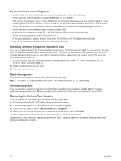
... total system load is receiving less than 100 A, it turns off all electrical connections for additional data storage. Outputs turn back on your vehicle's battery if it clicks. The device supports microSD memory cards from an electronics supplier, or purchase pre-loaded Garmin mapping software (www.garmin.com). Memory cards greater than 32 GB must use the FAT32 file system format. About Memory Cards You can be formatted using a USB cable. 1 Plug the small end of the USB cable into the...
... total system load is receiving less than 100 A, it turns off all electrical connections for additional data storage. Outputs turn back on your vehicle's battery if it clicks. The device supports microSD memory cards from an electronics supplier, or purchase pre-loaded Garmin mapping software (www.garmin.com). Memory cards greater than 32 GB must use the FAT32 file system format. About Memory Cards You can be formatted using a USB cable. 1 Plug the small end of the USB cable into the...

