Owner's Manual
Page 4
... Turn Radio/GPS On/Off 17 Informational Picture 18 GPS Status 18 Radio Transmission Status 18 ii Mark Waypoint's Indicators 19 Using the Rino 120 Radio Features 20 Peer-to-Peer Positioning 20 New Contact Page Overview 20 Sending a Location 23 Map Page 24 Map Page Options 26 Using the Pan Map Option 27 Programming the Data Fields 28 Data Field Options 28 Setting up the Map 29 General Setup 30 Tracks Setup 30 Map Features Setup 30 Text Setup 31 Map Data Setup 31 Measuring Distance...
... Turn Radio/GPS On/Off 17 Informational Picture 18 GPS Status 18 Radio Transmission Status 18 ii Mark Waypoint's Indicators 19 Using the Rino 120 Radio Features 20 Peer-to-Peer Positioning 20 New Contact Page Overview 20 Sending a Location 23 Map Page 24 Map Page Options 26 Using the Pan Map Option 27 Programming the Data Fields 28 Data Field Options 28 Setting up the Map 29 General Setup 30 Tracks Setup 30 Map Features Setup 30 Text Setup 31 Map Data Setup 31 Measuring Distance...

Owner's Manual
Page 5
... Rino® 120 Owner's Manual INTRODUCTION > TABLE OF CONTENTS Navigating a Route 62 Stopping Navigation 63 Data Fields for the Route Page 63 Data field options for Route Page 63 Tracks Page 64 Using the TracBack Feature 65 Setting up the Track Log 66 Proximity Page 67 Satellite Page 68 Sky View graphic 68 WAAS 69 Satellite Strength 69 Satellite Page Options 70 Setup Pages 72 Time Setup Page 72 Units Setup Page 73 LORAN TD Format 74 Display Setup...
... Rino® 120 Owner's Manual INTRODUCTION > TABLE OF CONTENTS Navigating a Route 62 Stopping Navigation 63 Data Fields for the Route Page 63 Data field options for Route Page 63 Tracks Page 64 Using the TracBack Feature 65 Setting up the Track Log 66 Proximity Page 67 Satellite Page 68 Sky View graphic 68 WAAS 69 Satellite Strength 69 Satellite Page Options 70 Setup Pages 72 Time Setup Page 72 Units Setup Page 73 LORAN TD Format 74 Display Setup...
Owner's Manual
Page 7
..., GPS-enabled handheld device. Using MapSource®, Garmin's map data software (not included), the Rino 120 could display up to 20 tracks with the Rino 120 including our MetroGuide®, Topo, Fishing Hot Spots, and BlueChart® data. The Rino 120 is waterproof to start navigating with a 10-character name and graphic symbol. Garmin's user-friendly interface allows you are compatible with up to two miles using 14 FRS (Family Radio Service) channels...
..., GPS-enabled handheld device. Using MapSource®, Garmin's map data software (not included), the Rino 120 could display up to 20 tracks with the Rino 120 including our MetroGuide®, Topo, Fishing Hot Spots, and BlueChart® data. The Rino 120 is waterproof to start navigating with a 10-character name and graphic symbol. Garmin's user-friendly interface allows you are compatible with up to two miles using 14 FRS (Family Radio Service) channels...
Owner's Manual
Page 26
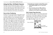
... time that are monitoring the same channel and squelch code. From the New Contact Page you to track the movement of other Rino users and even navigate to transmit its position. This section reviews some of the Rino 120. Locations may only be sent once every 30 seconds due to enhance your radio experience, such as transmitting locations and receiving contact information. Refer to the "Features" section for information...
... time that are monitoring the same channel and squelch code. From the New Contact Page you to track the movement of other Rino users and even navigate to transmit its position. This section reviews some of the Rino 120. Locations may only be sent once every 30 seconds due to enhance your radio experience, such as transmitting locations and receiving contact information. Refer to the "Features" section for information...
Owner's Manual
Page 33
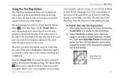
... item, project a waypoint from it, save it as the map pointer) in order to waypoints, roads, lakes, rivers; When using the panning arrow, press and hold the Thumb Stick In to as a waypoint, set a proximity Rino® 120 Owner's Manual UNIT OPERATION > MAP PAGE circle around it, add it to a route, or view the Sun & Moon or Hunt & Fish information for the items nearest the location of the map pointer instead of...
... item, project a waypoint from it, save it as the map pointer) in order to waypoints, roads, lakes, rivers; When using the panning arrow, press and hold the Thumb Stick In to as a waypoint, set a proximity Rino® 120 Owner's Manual UNIT OPERATION > MAP PAGE circle around it, add it to a route, or view the Sun & Moon or Hunt & Fish information for the items nearest the location of the map pointer instead of...
Owner's Manual
Page 34
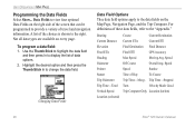
...Bearing Course Current Destination Current Distance Current ETA Current ETE Elevation Final Destination Final Distance Final ETA Final ETE GPS Accuracy Heading Max Speed Moving Avg. Not all data types are available on the Map Page, Navigation Page, and the Trip Computer. Speed Odometer Pointer Off Course Speed Overall Avg. Changing Data Fields Data Field Options Thee data field options apply to provide a variety of Day To Course Trip Odometer Trip Time-Movg. UNIT OPERATION > MAP PAGE Programming the Data Fields Select Show... Data Fields to view...
...Bearing Course Current Destination Current Distance Current ETA Current ETE Elevation Final Destination Final Distance Final ETA Final ETE GPS Accuracy Heading Max Speed Moving Avg. Not all data types are available on the Map Page, Navigation Page, and the Trip Computer. Speed Odometer Pointer Off Course Speed Overall Avg. Changing Data Fields Data Field Options Thee data field options apply to provide a variety of Day To Course Trip Odometer Trip Time-Movg. UNIT OPERATION > MAP PAGE Programming the Data Fields Select Show... Data Fields to view...
Owner's Manual
Page 48
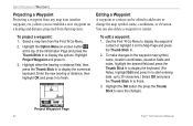
... In to start entering data, up to 30 characters.) Select OK and press the Thumb Stick In to finish. Use the Find 'N Go Menu to add notes or change the map symbol, name, coordinates, or elevation. To project a waypoint: 1. Editing a Waypoint A waypoint or contact can also delete a waypoint or contact. You can be edited to display the waypoint/ contact or highlight it on -screen button at the top of the Information Page...
... In to start entering data, up to 30 characters.) Select OK and press the Thumb Stick In to finish. Use the Find 'N Go Menu to add notes or change the map symbol, name, coordinates, or elevation. To project a waypoint: 1. Editing a Waypoint A waypoint or contact can also delete a waypoint or contact. You can be edited to display the waypoint/ contact or highlight it on -screen button at the top of the Information Page...

Owner's Manual
Page 51
... map, or select Delete to display the Waypoints List. 2. Nearest Waypoints selected in Find N' Go Menu Rino® 120 Owner's Manual UNIT OPERATION > FIND 'N GO To find a waypoint near your current location: 1. You can be found by selecting the Waypoint option from the Find 'N Go Menu. The Waypoint Information Page displays the waypoint name or number, a map symbol, the location in lat/lon, elevation, distance, bearing, and three on the Waypoint Information Page. Finding a Waypoint Waypoints that you have created and stored in the Rino 120...
... map, or select Delete to display the Waypoints List. 2. Nearest Waypoints selected in Find N' Go Menu Rino® 120 Owner's Manual UNIT OPERATION > FIND 'N GO To find a waypoint near your current location: 1. You can be found by selecting the Waypoint option from the Find 'N Go Menu. The Waypoint Information Page displays the waypoint name or number, a map symbol, the location in lat/lon, elevation, distance, bearing, and three on the Waypoint Information Page. Finding a Waypoint Waypoints that you have created and stored in the Rino 120...
Owner's Manual
Page 80
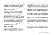
... Save and press In. For more information on the LORAN signal for navigation, it always references the LORAN chain number and secondary stations currently selected in decimal numbers; mmm' displays the latitude and longitude in memory. German Grid; India Zones; Swedish Grid; The default position format, 'hddd°mm. Taiwan Grid; Because the unit does not rely on Loran TDs, you to open the Loran TD setup...
... Save and press In. For more information on the LORAN signal for navigation, it always references the LORAN chain number and secondary stations currently selected in decimal numbers; mmm' displays the latitude and longitude in memory. German Grid; India Zones; Swedish Grid; The default position format, 'hddd°mm. Taiwan Grid; Because the unit does not rely on Loran TDs, you to open the Loran TD setup...

Owner's Manual
Page 81
... be changed when using maps or charts specifying a different datum. UNIT OPERATION > SETUP PAGES NOTE: The User datum is based on datums and coordinate systems. Distance/Speed-Choose from Stays On or delays of measure to display your elevation and vertical speed. If necessary, you are comparing GPS coordinates to a paper map, chart, or other reference, the map datum in this field must match the horizontal map datum used to generate the map or other reference. Map Datum-Offers a selection...
... be changed when using maps or charts specifying a different datum. UNIT OPERATION > SETUP PAGES NOTE: The User datum is based on datums and coordinate systems. Distance/Speed-Choose from Stays On or delays of measure to display your elevation and vertical speed. If necessary, you are comparing GPS coordinates to a paper map, chart, or other reference, the map datum in this field must match the horizontal map datum used to generate the map or other reference. Map Datum-Offers a selection...
Owner's Manual
Page 83
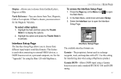
... Page key or the Menu icon the Main Menu. Highlight the field and then press the Thumb Stick In to activate. Rino® 120 Owner's Manual UNIT OPERATION > SETUP PAGES To access the Interface Setup Page: 1. This feature is chosen, you to exchange waypoint, track, and map data with MapSource. North Reference-You can choose from True, Magnetic, Grid or User options. Select the Interface icon to external NMEA devices, a DGPS beacon receiver, a personal...
... Page key or the Menu icon the Main Menu. Highlight the field and then press the Thumb Stick In to activate. Rino® 120 Owner's Manual UNIT OPERATION > SETUP PAGES To access the Interface Setup Page: 1. This feature is chosen, you to exchange waypoint, track, and map data with MapSource. North Reference-You can choose from True, Magnetic, Grid or User options. Select the Interface icon to external NMEA devices, a DGPS beacon receiver, a personal...
Owner's Manual
Page 84
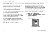
... receiver. UNIT OPERATION > SETUP PAGES NMEA In/NMEA Out-Supports the output of location and velocity information. None-Provides no interfacing capabilities. Highlight the Serial Data Format field and then press the Thumb Stick In. 2. RTCM In/NMEA Out-Allows DGPS input using a standard RTCM SC-104 format without input capabilities. Interface Setup Page 78 Rino® 120 Owner's Manual Tuning is selected, additional fields are provided to the beacon receiver instructions...
... receiver. UNIT OPERATION > SETUP PAGES NMEA In/NMEA Out-Supports the output of location and velocity information. None-Provides no interfacing capabilities. Highlight the Serial Data Format field and then press the Thumb Stick In. 2. RTCM In/NMEA Out-Allows DGPS input using a standard RTCM SC-104 format without input capabilities. Interface Setup Page 78 Rino® 120 Owner's Manual Tuning is selected, additional fields are provided to the beacon receiver instructions...
Owner's Manual
Page 85
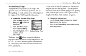
... Page key or the Menu icon to open the System Setup Page. The Option Menu allows you to change the battery type: 1. Number. To change GPS operation modes, use the Thumb Stick to select the desired option and press In. System Setup Page The System Setup Page allows you restore defaults or display the current version of satellite signal position updating and the GPS Off option stops satellite signal reception altogether. Select the System icon to System Setup Page open the Main Menu. 2. UNIT OPERATION > SETUP PAGES...
... Page key or the Menu icon to open the System Setup Page. The Option Menu allows you to change the battery type: 1. Number. To change GPS operation modes, use the Thumb Stick to select the desired option and press In. System Setup Page The System Setup Page allows you restore defaults or display the current version of satellite signal position updating and the GPS Off option stops satellite signal reception altogether. Select the System icon to System Setup Page open the Main Menu. 2. UNIT OPERATION > SETUP PAGES...
Owner's Manual
Page 93
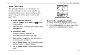
... a location or view a saved track. to store the area as you are ready to begin. 3. In the Main Menu, scroll down and select the Area Calculator icon. Be sure the Rino 120 has a GPS fix. 2. To calculate the area: 1. On the Tracks Page, highlight a Saved Track. 2. The area calculation displays in a data field at the bottom. 87 To access the Area Calculator: 1. Rino® 120 Owner's Manual UNIT OPERATION > AREA...
... a location or view a saved track. to store the area as you are ready to begin. 3. In the Main Menu, scroll down and select the Area Calculator icon. Be sure the Rino 120 has a GPS fix. 2. To calculate the area: 1. On the Tracks Page, highlight a Saved Track. 2. The area calculation displays in a data field at the bottom. 87 To access the Area Calculator: 1. Rino® 120 Owner's Manual UNIT OPERATION > AREA...
Owner's Manual
Page 101
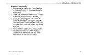
... cap. 2. To setup for unit interface settings. Turn on your computer. 3. APPENDIX > TRANSFERRING MAPSOURCE DATA Rino® 120 Owner's Manual 95 Remove weather cap from the Power/Data Port on the back of the unit and push the connector until it is fully seated in the MapSource User's Manual. Connect the remaining cable connector to an available serial port on the Rino 120 and follow instructions for map data transfer provided in the unit. 4. See also...
... cap. 2. To setup for unit interface settings. Turn on your computer. 3. APPENDIX > TRANSFERRING MAPSOURCE DATA Rino® 120 Owner's Manual 95 Remove weather cap from the Power/Data Port on the back of the unit and push the connector until it is fully seated in the MapSource User's Manual. Connect the remaining cable connector to an available serial port on the Rino 120 and follow instructions for map data transfer provided in the unit. 4. See also...
Owner's Manual
Page 104
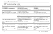
... with new batteries. button in the direction of satellites is turned off. Remedy Replace batteries. Replace batteries. Unit does not turn on the Map Page easily. It takes more than ten minutes to something other than Normal and/or interface setting is set to get a location fix The unit's view of the satellite. Cannot view a track being laid down on -screen button and then press the Thumb Stick In. 98 Rino® 120 Owner's Manual Reinstall batteries. You...
... with new batteries. button in the direction of satellites is turned off. Remedy Replace batteries. Replace batteries. Unit does not turn on the Map Page easily. It takes more than ten minutes to something other than Normal and/or interface setting is set to get a location fix The unit's view of the satellite. Cannot view a track being laid down on -screen button and then press the Thumb Stick In. 98 Rino® 120 Owner's Manual Reinstall batteries. You...
Owner's Manual
Page 114
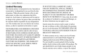
... YOU SPECIFIC LEGAL RIGHTS, WHICH MAY VARY FROM STATE TO STATE. 108 IN NO EVENT SHALL GARMIN BE LIABLE FOR ANY INCIDENTAL, SPECIAL, INDIRECT OR CONSEQUENTIAL DAMAGES, WHETHER RESULTING FROM THE USE, MISUSE, OR INABILITY TO USE THIS PRODUCT OR FROM DEFECTS IN THE PRODUCT. The unit should be free from the date of the original Rino® 120 Owner's Manual
... YOU SPECIFIC LEGAL RIGHTS, WHICH MAY VARY FROM STATE TO STATE. 108 IN NO EVENT SHALL GARMIN BE LIABLE FOR ANY INCIDENTAL, SPECIAL, INDIRECT OR CONSEQUENTIAL DAMAGES, WHETHER RESULTING FROM THE USE, MISUSE, OR INABILITY TO USE THIS PRODUCT OR FROM DEFECTS IN THE PRODUCT. The unit should be free from the date of the original Rino® 120 Owner's Manual
Owner's Manual
Page 122
... 69, 79 Waterproof 1, 91 Waypoint 40, 41 Create 40, 41 Delete 43 Edit 42 Move 43 Project 42 Z Zoom 25, 30 Rino® 120 Owner's Manual INDEX Routes 57 Copy 59 Create 57 Data Fields 63 Delete 59 Edit 58 Navigate 62 Remove waypoints 58 Restore defaults 59 Reverse 58 Review 59 S Satellite Fix 8 Satellite Information 8 Satellite Page 67 GPS Off 69 New Location 70 North Up 70 Options 70 Track Up 70 Save as a Waypoint 48, 49, 51 Scanlist...
... 69, 79 Waterproof 1, 91 Waypoint 40, 41 Create 40, 41 Delete 43 Edit 42 Move 43 Project 42 Z Zoom 25, 30 Rino® 120 Owner's Manual INDEX Routes 57 Copy 59 Create 57 Data Fields 63 Delete 59 Edit 58 Navigate 62 Remove waypoints 58 Restore defaults 59 Reverse 58 Review 59 S Satellite Fix 8 Satellite Information 8 Satellite Page 67 GPS Off 69 New Location 70 North Up 70 Options 70 Track Up 70 Save as a Waypoint 48, 49, 51 Scanlist...

Quick Start Guide
Page 1
... Instructions to begin navigation using the data entry keyboard. These may "poll" the contact's location. Sending a Note You can be turned on and tracking satellites to communicate silently with Your Rino 120 You can show the user's location on the same channel and squelch code that contact's location in the unit's memory. This can send a note to mark a waypoint. With the Waypoint Page displayed, highlight the Goto button at the top of Rino 120, refer to all Rinos...
... Instructions to begin navigation using the data entry keyboard. These may "poll" the contact's location. Sending a Note You can be turned on and tracking satellites to communicate silently with Your Rino 120 You can show the user's location on the same channel and squelch code that contact's location in the unit's memory. This can send a note to mark a waypoint. With the Waypoint Page displayed, highlight the Goto button at the top of Rino 120, refer to all Rinos...
Quick Start Guide
Page 2
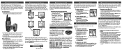
... Page Menu button . You can communicate with different types of about 3-4 inches. 2. Main Page Menu button Option Menu button 3 Initializing the GPS Before the Rino 120 can be used for navigation, the message "3D Accuracy" is displayed on the Radio Page. Initialization allows the Rino 120 to turn counter-clockwise and pull the cover off . To initialize the unit (acquire satellites): 1. Tracking Satellite Signals 3. To enter characters with other Rino users. To select a squelch code: 1. Selecting the channel 6 Changing...
... Page Menu button . You can communicate with different types of about 3-4 inches. 2. Main Page Menu button Option Menu button 3 Initializing the GPS Before the Rino 120 can be used for navigation, the message "3D Accuracy" is displayed on the Radio Page. Initialization allows the Rino 120 to turn counter-clockwise and pull the cover off . To initialize the unit (acquire satellites): 1. Tracking Satellite Signals 3. To enter characters with other Rino users. To select a squelch code: 1. Selecting the channel 6 Changing...


