Owner's Manual
Page 4
... Informational Picture 16 GPS Status 16 Radio Transmission Status 16 Mark Waypoint's Indicators 17 ii Using the Rino 110 Radio Features 18 Peer-to-Peer Positioning 18 New Contact Page Overview 18 Sending a Location 21 Map Page 22 Map Page Options 24 Using the Pan Map Option 25 Programming the Data Fields 26 Data Field Options 26 Setting up the Map 27 General Setup 27 Tracks Setup 28 Map Features Setup 28 Text Setup 28 Map Data Setup 28 Measuring Distance 28 Navigation Page 29 Using the Navigation...
... Informational Picture 16 GPS Status 16 Radio Transmission Status 16 Mark Waypoint's Indicators 17 ii Using the Rino 110 Radio Features 18 Peer-to-Peer Positioning 18 New Contact Page Overview 18 Sending a Location 21 Map Page 22 Map Page Options 24 Using the Pan Map Option 25 Programming the Data Fields 26 Data Field Options 26 Setting up the Map 27 General Setup 27 Tracks Setup 28 Map Features Setup 28 Text Setup 28 Map Data Setup 28 Measuring Distance 28 Navigation Page 29 Using the Navigation...
Owner's Manual
Page 7
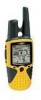
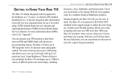
... actual maps), including GETTING STARTED > GETTING TO KNOW YOUR RINO 110 businesses, cities, landmarks, and marine points. It also has integrated radio functionality to IEC 60529 IPX7 standards and is a 7.6 ounce, 12-channel, GPS-enabled handheld device. GETTING TO KNOW YOUR RINO 110 The Rino 110 (Radio Integrated with your new GPS in mind. For more information about GMRS, refer to two miles using 14 FRS (Family Radio Service...
... actual maps), including GETTING STARTED > GETTING TO KNOW YOUR RINO 110 businesses, cities, landmarks, and marine points. It also has integrated radio functionality to IEC 60529 IPX7 standards and is a 7.6 ounce, 12-channel, GPS-enabled handheld device. GETTING TO KNOW YOUR RINO 110 The Rino 110 (Radio Integrated with your new GPS in mind. For more information about GMRS, refer to two miles using 14 FRS (Family Radio Service...
Owner's Manual
Page 13
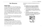
... store satellite information and begin using the satellites for satellite signals. The initialization process allows the Rino 110 to search for navigation. Garmin Rino units work with other radios use the Radio Page to control and setup the radio, view current settings, and see informational graphics of the default Main Pages. Also use standard FRS/GMRS frequencies. Take the Rino 110 outside where it has an unobstructed view of the Rino 110 features, the GPS receiver must be initialized. UNIT OPERATION...
... store satellite information and begin using the satellites for satellite signals. The initialization process allows the Rino 110 to search for navigation. Garmin Rino units work with other radios use the Radio Page to control and setup the radio, view current settings, and see informational graphics of the default Main Pages. Also use standard FRS/GMRS frequencies. Take the Rino 110 outside where it has an unobstructed view of the Rino 110 features, the GPS receiver must be initialized. UNIT OPERATION...

Owner's Manual
Page 24
... Rino users: 1. This information is being able to send its position. A flag on your Map, Goto their location, or add them to -Peer positioning. This section reviews some of other Rino users and even navigate to their location on the top Status Bar or in Mark's hand indicates the unit is ready to transmit its location to another Rino user, the New Contact Page is received from other Rino users that a signal is displayed...
... Rino users: 1. This information is being able to send its position. A flag on your Map, Goto their location, or add them to -Peer positioning. This section reviews some of other Rino users and even navigate to their location on the top Status Bar or in Mark's hand indicates the unit is ready to transmit its location to another Rino user, the New Contact Page is received from other Rino users that a signal is displayed...
Owner's Manual
Page 28
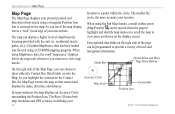
... show either the Contact Bar, Data Fields, or only the Map. As you zoom in defining your 22 Accuracy Circle Map Scale Contact Bar Position Icon Rino® 110 Owner's Manual UNIT OPERATION > MAP PAGE Map Page The Map Page displays your present position and direction of movement using a triangular Position Icon that is centered on that contact and displays its name, direction, and distance. When using a CD-ROM mapping program. The Rino 110 uses both map resolution and GPS accuracy in to view map...
... show either the Contact Bar, Data Fields, or only the Map. As you zoom in defining your 22 Accuracy Circle Map Scale Contact Bar Position Icon Rino® 110 Owner's Manual UNIT OPERATION > MAP PAGE Map Page The Map Page displays your present position and direction of movement using a triangular Position Icon that is centered on that contact and displays its name, direction, and distance. When using a CD-ROM mapping program. The Rino 110 uses both map resolution and GPS accuracy in to view map...

Owner's Manual
Page 31
... feature applies to view areas beyond the current viewing area on the display. The Option Menu allows you to send the location of the map display, the map also moves to the Map Page. On-screen buttons at and identify items on the map, and to move the panning arrow (also referred to mark the arrow location or display the map item Information Page. Press the Page key to display the Shortcuts Menu. 2. When using...
... feature applies to view areas beyond the current viewing area on the display. The Option Menu allows you to send the location of the map display, the map also moves to the Map Page. On-screen buttons at and identify items on the map, and to move the panning arrow (also referred to mark the arrow location or display the map item Information Page. Press the Page key to display the Shortcuts Menu. 2. When using...
Owner's Manual
Page 33
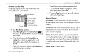
... top of the map display to the current track heading or to display the Map Setup Page. 2. controls how much map detail you are unaffected by an on the list. Rino® 110 Owner's Manual UNIT OPERATION > MAP PAGE Press Right to return to the left. 3. Setting up the Map Setup Map displays the five Map Setup Pages, each accessed by this setting. Setup Items Sub-Page Buttons Options General Setup Lines Setup Points Setup Text Setup Map Data Setup To use Map Setup options: 1.
... top of the map display to the current track heading or to display the Map Setup Page. 2. controls how much map detail you are unaffected by an on the list. Rino® 110 Owner's Manual UNIT OPERATION > MAP PAGE Press Right to return to the left. 3. Setting up the Map Setup Map displays the five Map Setup Pages, each accessed by this setting. Setup Items Sub-Page Buttons Options General Setup Lines Setup Points Setup Text Setup Map Data Setup To use Map Setup options: 1.
Owner's Manual
Page 34
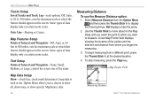
... on the screen. Map Pointer Field Measuring Distance Rino® 110 Owner's Manual UNIT OPERATION > MAP PAGE Tracks Setup Saved Tracks and Track Log-scale options; Off, Auto, or 20 ft.-500 miles, sets the maximum scale at which the feature should appear on the screen. Map Features Setup Points of Interest and Waypoints-None, Small, Medium, or Large; Ref displays under the arrow. 2. Some types of data display only at the desired location. 4. control the screen size of the pointer and the direction and distance from...
... on the screen. Map Pointer Field Measuring Distance Rino® 110 Owner's Manual UNIT OPERATION > MAP PAGE Tracks Setup Saved Tracks and Track Log-scale options; Off, Auto, or 20 ft.-500 miles, sets the maximum scale at which the feature should appear on the screen. Map Features Setup Points of Interest and Waypoints-None, Small, Medium, or Large; Ref displays under the arrow. 2. Some types of data display only at the desired location. 4. control the screen size of the pointer and the direction and distance from...

Owner's Manual
Page 47
... Menu. The Waypoint Information Page displays the waypoint name or number, a map symbol, the location in Find 'N Go Menu Rino® 110 Owner's Manual UNIT OPERATION > FIND 'N GO To find a waypoint by selecting the Waypoint option from the list of travel to the waypoint. Press the Thumb Stick In to delete the waypoint. 4. Nearest Waypoints selected in lat/lon, elevation, distance, bearing, and three on-screen buttons for that waypoint), or Reposition Here. 41 Finding a Waypoint Waypoints that you have created...
... Menu. The Waypoint Information Page displays the waypoint name or number, a map symbol, the location in Find 'N Go Menu Rino® 110 Owner's Manual UNIT OPERATION > FIND 'N GO To find a waypoint by selecting the Waypoint option from the list of travel to the waypoint. Press the Thumb Stick In to delete the waypoint. 4. Nearest Waypoints selected in lat/lon, elevation, distance, bearing, and three on-screen buttons for that waypoint), or Reposition Here. 41 Finding a Waypoint Waypoints that you have created...
Owner's Manual
Page 71
...; 110 Owner's Manual UNIT OPERATION > SETUP PAGES before storing the waypoint. For more information on the LORAN signal for navigation, it always references the LORAN chain number and secondary stations currently selected in memory. German Grid; Loran TD; After the waypoint is most commonly used. To adjust the Loran TD settings, select Loran TD as the Position Format to choose from the Garmin Web site at http://www.garmin.com/support/ userManual.jsp. 65 The default position format...
...; 110 Owner's Manual UNIT OPERATION > SETUP PAGES before storing the waypoint. For more information on the LORAN signal for navigation, it always references the LORAN chain number and secondary stations currently selected in memory. German Grid; Loran TD; After the waypoint is most commonly used. To adjust the Loran TD settings, select Loran TD as the Position Format to choose from the Garmin Web site at http://www.garmin.com/support/ userManual.jsp. 65 The default position format...
Owner's Manual
Page 74
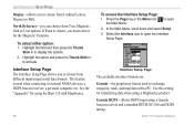
... for using the Rino 110 with a PC. Rino® 110 Owner's Manual If User is used to exchange waypoint, track, and map data with MapSource. 68 To access the Interface Setup Page: 1. In the Main Menu, scroll down and select Setup. 3. Interface Setup Page The available interface formats are: Garmin-the proprietary format used when connecting to external NMEA devices, a DGPS beacon receiver, a personal computer, etc. Garmin DGPS-allows DGPS input using a MapSource product. Use this setting for transferring data when using a Garmin beacon receiver...
... for using the Rino 110 with a PC. Rino® 110 Owner's Manual If User is used to exchange waypoint, track, and map data with MapSource. 68 To access the Interface Setup Page: 1. In the Main Menu, scroll down and select Setup. 3. Interface Setup Page The available interface formats are: Garmin-the proprietary format used when connecting to external NMEA devices, a DGPS beacon receiver, a personal computer, etc. Garmin DGPS-allows DGPS input using a MapSource product. Use this setting for transferring data when using a Garmin beacon receiver...
Owner's Manual
Page 75
... text output of standard NMEA 0183 version 3.0 data. UNIT OPERATION > SETUP PAGES If Garmin DGPS or RTCM In/NMEA Out format is automatic with MapSource or 3rd party programs. Text Out-allows ASCII text output of standard NMEA 0183 version 3.0 data. Highlight an option and then press the Thumb Stick In to the beacon receiver instructions. Interface Setup Page Rino® 110 Owner's Manual 69 None-provides no interfacing capabilities. Refer...
... text output of standard NMEA 0183 version 3.0 data. UNIT OPERATION > SETUP PAGES If Garmin DGPS or RTCM In/NMEA Out format is automatic with MapSource or 3rd party programs. Text Out-allows ASCII text output of standard NMEA 0183 version 3.0 data. Highlight an option and then press the Thumb Stick In to the beacon receiver instructions. Interface Setup Page Rino® 110 Owner's Manual 69 None-provides no interfacing capabilities. Refer...
Owner's Manual
Page 76
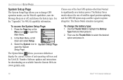
... the Battery Type field and then press In. 2. UNIT OPERATION > SETUP PAGES System Setup Page The System Setup Page allows you restore defaults or display the current version of unit operating software and the Unit I.D. See the "Appendix" for downloading are available from the Garmin Web site (www.garmin.com). Select the System icon to open the System Setup Page. Number. The Battery Saver mode reduces the rate of satellite signal position updating and the GPS Off option stops satellite signal reception...
... the Battery Type field and then press In. 2. UNIT OPERATION > SETUP PAGES System Setup Page The System Setup Page allows you restore defaults or display the current version of unit operating software and the Unit I.D. See the "Appendix" for downloading are available from the Garmin Web site (www.garmin.com). Select the System icon to open the System Setup Page. Number. The Battery Saver mode reduces the rate of satellite signal position updating and the GPS Off option stops satellite signal reception...
Owner's Manual
Page 90
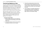
... serial port on the back of the unit and push the connector until it is not possible to transfer 3rd party maps into Garmin products. Map data transfer requires the use to provide your computer. 3. See also the "Interface Setup Page" section for data transfer in the MapSource User's Manual. Connect the remaining cable connector to the back of the Rino 110 by lifting up to 1 MB of map data...
... serial port on the back of the unit and push the connector until it is not possible to transfer 3rd party maps into Garmin products. Map data transfer requires the use to provide your computer. 3. See also the "Interface Setup Page" section for data transfer in the MapSource User's Manual. Connect the remaining cable connector to the back of the Rino 110 by lifting up to 1 MB of map data...
Owner's Manual
Page 93
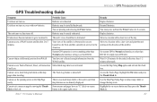
.... Unit does not turn on -screen Stick to a locatin with a clear view of the satellite. Move to other than RTCM. The Track Log feature is turned off WAAS. Rino® 110 Owner's Manual 87 Set system GPS to Normal and interface to a location with new batteries. Cannot obtain a differential position from WAAS You have an "X" (Exit) on , even with a clear view and point the unit antenna in the direction of the sky. Access the Map Setup Map...
.... Unit does not turn on -screen Stick to a locatin with a clear view of the satellite. Move to other than RTCM. The Track Log feature is turned off WAAS. Rino® 110 Owner's Manual 87 Set system GPS to Normal and interface to a location with new batteries. Cannot obtain a differential position from WAAS You have an "X" (Exit) on , even with a clear view and point the unit antenna in the direction of the sky. Access the Map Setup Map...
Owner's Manual
Page 101
The Garmin Rino 110 has no user-serviceable parts. The Rino 110 is fastened shut with your unit, please take it to an authorized Garmin dealer for your unit. The unit should be securely packed with the tracking number clearly written on the outside the United States. Online auction confirmations are not accepted for units purchased outside of the sales receipt from any package purchased through online auctions...
The Garmin Rino 110 has no user-serviceable parts. The Rino 110 is fastened shut with your unit, please take it to an authorized Garmin dealer for your unit. The unit should be securely packed with the tracking number clearly written on the outside the United States. Online auction confirmations are not accepted for units purchased outside of the sales receipt from any package purchased through online auctions...
Owner's Manual
Page 107
... Bearing Pointer/Course Pointer 31 Options 31 Restore Defaults 31 Stop Navigation 31 New Contact 18 New Location 62 NMEA 0183 92 North Heading 27 North Up 27, 62 Note 71 O Operating the Rino 5 Option Menu 5 Orientation 27 P Page Sequence Setup 34 Pan Map 24, 25 PC 84, 92 PC Interface Cable 84 Peer-to-Peer 14, 18 PIT 15 Points of Interest 45, 46 Polling 14 Poll Location 43 Position Icon 22 Program a Data Field...
... Bearing Pointer/Course Pointer 31 Options 31 Restore Defaults 31 Stop Navigation 31 New Contact 18 New Location 62 NMEA 0183 92 North Heading 27 North Up 27, 62 Note 71 O Operating the Rino 5 Option Menu 5 Orientation 27 P Page Sequence Setup 34 Pan Map 24, 25 PC 84, 92 PC Interface Cable 84 Peer-to-Peer 14, 18 PIT 15 Points of Interest 45, 46 Polling 14 Poll Location 43 Position Icon 22 Program a Data Field...
Owner's Manual
Page 108
... Waterproof 1, 81 Waypoint 36, 37 Create 36, 37 Delete 39 Edit 38 Move 39 Project 38 Z Zoom 23, 27 Rino® 110 Owner's Manual INDEX Use 49 S Satellite Fix 7 Satellite Information 7 Satellite Page 59 GPS Off 61 Options 62 Sky View 60 Save as a Waypoint 44, 46 Scales 23 Scanlist 12, 13, 16 Scan Codes 12, 13, 86 Send Location 14, 18, 21, 41, 42, 43, 44, 46 Set Alarm clock 73...
... Waterproof 1, 81 Waypoint 36, 37 Create 36, 37 Delete 39 Edit 38 Move 39 Project 38 Z Zoom 23, 27 Rino® 110 Owner's Manual INDEX Use 49 S Satellite Fix 7 Satellite Information 7 Satellite Page 59 GPS Off 61 Options 62 Sky View 60 Save as a Waypoint 44, 46 Scales 23 Scanlist 12, 13, 16 Scan Codes 12, 13, 86 Send Location 14, 18, 21, 41, 42, 43, 44, 46 Set Alarm clock 73...
Quick Start Guide
Page 1
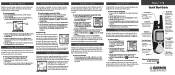
... Shortcuts Menu is displayed. 2. Highlight the Option Menu button Stick In. They can use the track log to Goto that location, view the location on the map (Map), or save the waypoint. Using Peer-to-Peer Positioning The Rino's most unique feature is Peer-to-Peer positioning, sending the location of Rino 110, refer to the Owner's Manual, which provides detailed information about all Rinos on the same channel and squelch code as you can show the user's location on a direct course toward...
... Shortcuts Menu is displayed. 2. Highlight the Option Menu button Stick In. They can use the track log to Goto that location, view the location on the map (Map), or save the waypoint. Using Peer-to-Peer Positioning The Rino's most unique feature is Peer-to-Peer positioning, sending the location of Rino 110, refer to the Owner's Manual, which provides detailed information about all Rinos on the same channel and squelch code as you can show the user's location on a direct course toward...
Quick Start Guide
Page 2
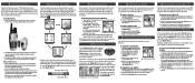
..., Map Page, Navigation Page, Trip Computer, and Main Menu Page. See the Rino 110 Owner's Manual for navigation, the message "3D Accuracy" is factory set to use it on. 2. Remove the battery cover on the back of the unit. Turn the D-ring 1/4 turn it for navigation, the GPS receiver must be used. Turn the D-ring 1/4 turn on the backlight and adjust the screen contrast: 1. Simply press and release the Page key to close the Backlight and Contrast window. "Tracking Satellites" is displayed...
..., Map Page, Navigation Page, Trip Computer, and Main Menu Page. See the Rino 110 Owner's Manual for navigation, the message "3D Accuracy" is factory set to use it on. 2. Remove the battery cover on the back of the unit. Turn the D-ring 1/4 turn it for navigation, the GPS receiver must be used. Turn the D-ring 1/4 turn on the backlight and adjust the screen contrast: 1. Simply press and release the Page key to close the Backlight and Contrast window. "Tracking Satellites" is displayed...


