
Owner's Manual
Page 11
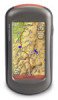
... choose a point on the map to navigate to a Destination You can use Where To? A colored line indicates your destination. Touch Where To?. 2. Oregon Series Owner's Manual 5 Touch > Compass. 6. To navigate to your current location. • Tides-a list of a location. Touch a category. 3. Basic Navigation &#...8226; All POI (Points of Interest)-if supported by the preloaded or optional mapping, various Points of Interest may be listed. • Cities-a list of the 50...
... choose a point on the map to navigate to a Destination You can use Where To? A colored line indicates your destination. Touch Where To?. 2. Oregon Series Owner's Manual 5 Touch > Compass. 6. To navigate to your current location. • Tides-a list of a location. Touch a category. 3. Basic Navigation &#...8226; All POI (Points of Interest)-if supported by the preloaded or optional mapping, various Points of Interest may be listed. • Cities-a list of the 50...

Owner's Manual
Page 12
... . 3. Touch . 5. Touch the information button at the top of your destination as indicated on page 9. 6 Oregon Series Owner's Manual Basic Navigation To find a destination by spelling the name: 1. On the Main menu, touch Where To? > All POI. 2. Touch characters to a point on the map. 3. A colored line indicates your destination as indicated on...
... . 3. Touch . 5. Touch the information button at the top of your destination as indicated on page 9. 6 Oregon Series Owner's Manual Basic Navigation To find a destination by spelling the name: 1. On the Main menu, touch Where To? > All POI. 2. Touch characters to a point on the map. 3. A colored line indicates your destination as indicated on...
Owner's Manual
Page 43
... smaller connector on the back of the cable to a USB port on your computer: 1. You can connect the Oregon to your Garmin dealer. Connecting Your Oregon to a Computer You can purchase microSD memory cards from an electronics supplier, or purchase preloaded detailed map data cards ... cards can be used to http://buy. garmin.com for compatible map products. Installing a microSD Card The Oregon microSD card tray is turned off. Go to store files such as images, cartridges, geocaches, routes, waypoints, and custom POIs. Oregon Series Owner's Manual 37 Connect the other end...
... smaller connector on the back of the cable to a USB port on your computer: 1. You can connect the Oregon to your Garmin dealer. Connecting Your Oregon to a Computer You can purchase microSD memory cards from an electronics supplier, or purchase preloaded detailed map data cards ... cards can be used to http://buy. garmin.com for compatible map products. Installing a microSD Card The Oregon microSD card tray is turned off. Go to store files such as images, cartridges, geocaches, routes, waypoints, and custom POIs. Oregon Series Owner's Manual 37 Connect the other end...
Owner's Manual
Page 44
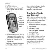
... file. 2. Browse your computer, you have connected the device to store files such as images, Wherigo cartridges, geocaches, routes, waypoints, and custom POIs. Lift the metal cover. 3. Replace the batteries and the battery cover. Select Edit > Paste. Select Edit > Copy. 4. In addition to map... and data storage, the microSD card can copy and paste files from www.garmin.com /products/communicator. 38 Oregon Series Owner's Manual To remove the microSD card, lift the metal cover and remove the card from the microSD card tray. 5....
... file. 2. Browse your computer, you have connected the device to store files such as images, Wherigo cartridges, geocaches, routes, waypoints, and custom POIs. Lift the metal cover. 3. Replace the batteries and the battery cover. Select Edit > Paste. Select Edit > Copy. 4. In addition to map... and data storage, the microSD card can copy and paste files from www.garmin.com /products/communicator. 38 Oregon Series Owner's Manual To remove the microSD card, lift the metal cover and remove the card from the microSD card tray. 5....
Owner's Manual
Page 50
Index G Garmin serial 25 Garmin spanner 25 geocaches 23 GPS setting 25 grid north 31 guidance method 28 H heart rate monitor 33, 34 I images viewing 20 interface 25 L language 25 ... 29 on road for distance 28 on road for time 28 orientation, map 26 P Photo Viewer 19 pictures 19 plot type 32 points of interest (POI) 5 position format 31 pressure ambient 32 barometric 32 trending 32 unit of measurement 30 profiles 24 R recent finds 5 record method, tracks 27 registering the...
Index G Garmin serial 25 Garmin spanner 25 geocaches 23 GPS setting 25 grid north 31 guidance method 28 H heart rate monitor 33, 34 I images viewing 20 interface 25 L language 25 ... 29 on road for distance 28 on road for time 28 orientation, map 26 P Photo Viewer 19 pictures 19 plot type 32 points of interest (POI) 5 position format 31 pressure ambient 32 barometric 32 trending 32 unit of measurement 30 profiles 24 R recent finds 5 record method, tracks 27 registering the...
