Important Safety and Product Information
Page 4
...or newly-overhauled replacement product) the device or software or offer a full refund of intended distribution. Garmin Australasia Unit 19, 167 Prospect Highway Seven Hills, NSW, Australia, 2147 Phone: 1800 822 235 Garmin's Marine Warranty Policy: Certain Garmin Marine products in certain areas have the goods repaired... une aide à la navigation. EXCLUSION OF INCIDENTAL OR CONSEQUENTIAL DAMAGES, SO THE ABOVE LIMITATIONS MAY NOT APPLY TO YOU. Garmin retains the exclusive right to repair or replace (with guarantees that cannot be of purchase for more details and to have a longer...
...or newly-overhauled replacement product) the device or software or offer a full refund of intended distribution. Garmin Australasia Unit 19, 167 Prospect Highway Seven Hills, NSW, Australia, 2147 Phone: 1800 822 235 Garmin's Marine Warranty Policy: Certain Garmin Marine products in certain areas have the goods repaired... une aide à la navigation. EXCLUSION OF INCIDENTAL OR CONSEQUENTIAL DAMAGES, SO THE ABOVE LIMITATIONS MAY NOT APPLY TO YOU. Garmin retains the exclusive right to repair or replace (with guarantees that cannot be of purchase for more details and to have a longer...
Chartplotter Configuration Guide for Mercury Zeus and Axius Systems
Page 1
...document describes the procedure to configure the following Garmin chartplotter series to work with Mercury Zeus and Axius systems: • GPSMAP 400/500 • GPSMAP 600 • GPSMAP 700 • GPSMAP 4000/5000 • GPSMAP 6000/7000 Check Chartplotter Software Before you can configure the chartplotter, you...SD card", click Download. • For the GPSMAP 4000/5000 and 6000/7000 series, in the section called "Garmin Marine Network with the Mercury Zeus or Axius system, you can use the chartplotter to check the software version currently on your chartplotter. 2. Select the ...
...document describes the procedure to configure the following Garmin chartplotter series to work with Mercury Zeus and Axius systems: • GPSMAP 400/500 • GPSMAP 600 • GPSMAP 700 • GPSMAP 4000/5000 • GPSMAP 6000/7000 Check Chartplotter Software Before you can configure the chartplotter, you...SD card", click Download. • For the GPSMAP 4000/5000 and 6000/7000 series, in the section called "Garmin Marine Network with the Mercury Zeus or Axius system, you can use the chartplotter to check the software version currently on your chartplotter. 2. Select the ...
Chartplotter Configuration Guide for Mercury Zeus and Axius Systems
Page 2
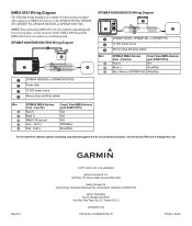
...899751T01) N/A N/A N/A White/Blue Blue/White For the latest free software updates (excluding map data) throughout the life of what you may encounter when wiring your Garmin products, visit the Garmin Web site at www.garmin.com. or its subsidiaries Garmin International, Inc. 1200 East 151st Street, Olathe, Kansas 66062, ...for the NMEA 2000 bus and the NMEA 0183 device to connect to the GPSMAP 400/500, GPSMAP 600, GPSMAP 700, GPSMAP 4000/5000, or GPSMAP 6000/7000. Tx/A (+) Pink - May 2011 © 2011 Garmin Ltd. B Printed in Taiwan NOTE: When connecting NMEA 0183 devices with ...
...899751T01) N/A N/A N/A White/Blue Blue/White For the latest free software updates (excluding map data) throughout the life of what you may encounter when wiring your Garmin products, visit the Garmin Web site at www.garmin.com. or its subsidiaries Garmin International, Inc. 1200 East 151st Street, Olathe, Kansas 66062, ...for the NMEA 2000 bus and the NMEA 0183 device to connect to the GPSMAP 400/500, GPSMAP 600, GPSMAP 700, GPSMAP 4000/5000, or GPSMAP 6000/7000. Tx/A (+) Pink - May 2011 © 2011 Garmin Ltd. B Printed in Taiwan NOTE: When connecting NMEA 0183 devices with ...
Installation Instructions
Page 12
...this manual onto a hard drive or other electronic storage medium to be viewed and to notify any purpose without notice. Garmin®, the Garmin logo, GPSMAP®, and AutoLocate® are trademarks of this copyright notice and provided further that such electronic or printed copy of...other countries. Visit the Garmin Web site (www.garmin.com) for any person or organization of the National Maritime Electronics Association. For the latest free software updates (excluding map data) throughout the life of your Garmin products, visit the Garmin Web site at www.garmin.com. © 2009...
...this manual onto a hard drive or other electronic storage medium to be viewed and to notify any purpose without notice. Garmin®, the Garmin logo, GPSMAP®, and AutoLocate® are trademarks of this copyright notice and provided further that such electronic or printed copy of...other countries. Visit the Garmin Web site (www.garmin.com) for any person or organization of the National Maritime Electronics Association. For the latest free software updates (excluding map data) throughout the life of your Garmin products, visit the Garmin Web site at www.garmin.com. © 2009...
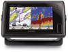
Owner's Manual
Page 5
... a VHF Radio 62 Adding a DSC Contact 63 Viewing the DSC List 63 Receiving Distress Calls 63 Man-Overboard Distress Calls Initiated from a VHF Radio 64 GPSMAP 400/500 Series Owner's Manual Introduction Man-Overboard Distress Calls Initiated from the Chartplotter 64 Position Tracking 64 Placing an Individual Routine Call 65 Calling... an AIS Target 66 Appendix 67 Specifications 67 Alarms and Messages 69 Capturing Screenshots 72 Caring for the Unit 72 Software License Agreement 73 Index 74 iii
... a VHF Radio 62 Adding a DSC Contact 63 Viewing the DSC List 63 Receiving Distress Calls 63 Man-Overboard Distress Calls Initiated from a VHF Radio 64 GPSMAP 400/500 Series Owner's Manual Introduction Man-Overboard Distress Calls Initiated from the Chartplotter 64 Position Tracking 64 Placing an Individual Routine Call 65 Calling... an AIS Target 66 Appendix 67 Specifications 67 Alarms and Messages 69 Capturing Screenshots 72 Caring for the Unit 72 Software License Agreement 73 Index 74 iii
Owner's Manual
Page 12
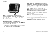
... options, tides, currents, celestial data, user data, and information about other screens. Note: You must have an "s" series unit (such as a GPSMAP 526s) with a connected transducer to use a BlueChart g2 Vision SD card. Note: Mariner's Eye 3D charts and Fish Eye 3D charts are available ... sonar features. • Chart/Sonar-set up the screen to the most-current version by clicking Help > Check for Software Updates, or check the Garmin Web site at www.garmin.com. Press HOME from MapSource® or HomePort™, update to view a chart and sonar in map supports Fishing...
... options, tides, currents, celestial data, user data, and information about other screens. Note: You must have an "s" series unit (such as a GPSMAP 526s) with a connected transducer to use a BlueChart g2 Vision SD card. Note: Mariner's Eye 3D charts and Fish Eye 3D charts are available ... sonar features. • Chart/Sonar-set up the screen to the most-current version by clicking Help > Check for Software Updates, or check the Garmin Web site at www.garmin.com. Press HOME from MapSource® or HomePort™, update to view a chart and sonar in map supports Fishing...
Owner's Manual
Page 45
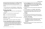
Waypoints-view a list of all user waypoints, routes, and tracks. Tracks-view a list of saved routes (page 26). GPSMAP 400/500 Series Owner's Manual Viewing Information 2. Insert the SD card into your chartplotter to allow it with existing user data. • Select ...your chartplotter, select Information > User Data > Data Transfer. 9. From the Home screen on the computer by clicking Help > Check for Software Updates, or check the Garmin Web site at www.garmin.com. 3. From the Send to Device window, select the drive for the SD card reader and the types of data you...
Waypoints-view a list of all user waypoints, routes, and tracks. Tracks-view a list of saved routes (page 26). GPSMAP 400/500 Series Owner's Manual Viewing Information 2. Insert the SD card into your chartplotter to allow it with existing user data. • Select ...your chartplotter, select Information > User Data > Data Transfer. 9. From the Home screen on the computer by clicking Help > Check for Software Updates, or check the Garmin Web site at www.garmin.com. 3. From the Send to Device window, select the drive for the SD card reader and the types of data you...
Owner's Manual
Page 54
...of your boat over a short period of system events. Simulator-turn Auto Power On or Off. The Garmin Devices > Save to purchase additional map data. A Garmin Product Support representative may need this feature to acquire satellites. • Speed Filter-select On, Off, or...darken the backlight. WAAS/EGNOS can view the software version, the basemap version, supplemental map information (if applicable), and the unit ID number for smoother speed values. Select Display > Backlight to view additional information. 48 GPSMAP 400/500 Series Owner's Manual Select Display >...
...of your boat over a short period of system events. Simulator-turn Auto Power On or Off. The Garmin Devices > Save to purchase additional map data. A Garmin Product Support representative may need this feature to acquire satellites. • Speed Filter-select On, Off, or...darken the backlight. WAAS/EGNOS can view the software version, the basemap version, supplemental map information (if applicable), and the unit ID number for smoother speed values. Select Display > Backlight to view additional information. 48 GPSMAP 400/500 Series Owner's Manual Select Display >...
Owner's Manual
Page 57
...Complete an action: • If the placement of the Auto Guidance line is satisfactory, select MENU > Navigation Options > Stop Navigation. GPSMAP 400/500 Series Owner's Manual 51 If you selected Nearest or Farthest in step 7, review the placement of the Auto Guidance line. ...Auto Guidance > Shoreline Distance > Nearest. Repeat steps 1-10 at least once more, using a different destination each time, until you are familiar with Garmin software. • NMEA Standard-supports the input or output of standard NMEA 0183 data, DSC, and sonar NMEA input support for most AIS receivers. ...
...Complete an action: • If the placement of the Auto Guidance line is satisfactory, select MENU > Navigation Options > Stop Navigation. GPSMAP 400/500 Series Owner's Manual 51 If you selected Nearest or Farthest in step 7, review the placement of the Auto Guidance line. ...Auto Guidance > Shoreline Distance > Nearest. Repeat steps 1-10 at least once more, using a different destination each time, until you are familiar with Garmin software. • NMEA Standard-supports the input or output of standard NMEA 0183 data, DSC, and sonar NMEA input support for most AIS receivers. ...
Owner's Manual
Page 77
... on . Transfer Complete-the unit has finished uploading or downloading information to "Stop When Full." Check the connections. GPSMAP 400/500 Series Owner's Manual 71 Contact your dealer or Garmin Product Support to needs a software update. Modify the track name or delete the existing track. User Card Not Found, Please Insert Card-attempted...
... on . Transfer Complete-the unit has finished uploading or downloading information to "Stop When Full." Check the connections. GPSMAP 400/500 Series Owner's Manual 71 Contact your dealer or Garmin Product Support to needs a software update. Modify the track name or delete the existing track. User Card Not Found, Please Insert Card-attempted...
Owner's Manual
Page 79
... source code form remains a valuable trade secret of Garmin. You agree not to export or re-export the Software to see a list of America. GPSMAP 421/421s GPSMAP 451/451s GPSMAP 551/551s GPSMAP 521/521s GPSMAP 526/526s GPSMAP 556/556s To connect one of these chartplotter to an ...of America copyright laws and international copyright treaties. NMEA 2000 The following GPSMAP 400 and GPSMAP 500 series chartplotters are NMEA 2000 certified and can receive data from a NMEA 2000 network installed on the Software. Garmin grants you a limited license to determine if the engine is displayed.
... source code form remains a valuable trade secret of Garmin. You agree not to export or re-export the Software to see a list of America. GPSMAP 421/421s GPSMAP 451/451s GPSMAP 551/551s GPSMAP 521/521s GPSMAP 526/526s GPSMAP 556/556s To connect one of these chartplotter to an ...of America copyright laws and international copyright treaties. NMEA 2000 The following GPSMAP 400 and GPSMAP 500 series chartplotters are NMEA 2000 certified and can receive data from a NMEA 2000 network installed on the Software. Garmin grants you a limited license to determine if the engine is displayed.
Owner's Manual
Page 82
...navigation preferences 50 system 48 76 units of measure 49 Shoreline Distance 50 simulator 48 mode 5 Skyview 48 software license agreement 73 software version 48 sonar advanced settings 61 cone 17 full screen 57 scroll speed 60 setting up 60-61 ... units of measure 49 user data backing up 40 clearing 39 transferring 40 viewing 39 V Vehicle Icon 13 version (software) 48 VHF radio 62 viewing currents 38 other boats 41 tide stations 37 user data 39 W WAAS 48 water ...23 Whiteline 60 wind gauge 36 close hauled 36, 37 Z zoom 61 2x 61 GPSMAP 400/500 Series Owner's Manual
...navigation preferences 50 system 48 76 units of measure 49 Shoreline Distance 50 simulator 48 mode 5 Skyview 48 software license agreement 73 software version 48 sonar advanced settings 61 cone 17 full screen 57 scroll speed 60 setting up 60-61 ... units of measure 49 user data backing up 40 clearing 39 transferring 40 viewing 39 V Vehicle Icon 13 version (software) 48 VHF radio 62 viewing currents 38 other boats 41 tide stations 37 user data 39 W WAAS 48 water ...23 Whiteline 60 wind gauge 36 close hauled 36, 37 Z zoom 61 2x 61 GPSMAP 400/500 Series Owner's Manual
Owner's Manual
Page 84
Liberty House, Hounsdown Business Park, Southampton, Hampshire, SO40 9LR UK Garmin Corporation No. 68, Zhangshu 2nd Road, Xizhi Dist., New Taipei City, 221, Taiwan (R.O.C.) www.garmin.com Part Number 190-01230-10 Rev. C Printed in Taiwan March 2012 © 2010-2012 Garmin Ltd. or its subsidiaries Garmin International, Inc. 1200 East 151st Street, Olathe, Kansas 66062, USA Garmin (Europe) Ltd. For the latest free software updates (excluding map data) throughout the life of your Garmin products, visit the Garmin Web site at www.garmin.com.
Liberty House, Hounsdown Business Park, Southampton, Hampshire, SO40 9LR UK Garmin Corporation No. 68, Zhangshu 2nd Road, Xizhi Dist., New Taipei City, 221, Taiwan (R.O.C.) www.garmin.com Part Number 190-01230-10 Rev. C Printed in Taiwan March 2012 © 2010-2012 Garmin Ltd. or its subsidiaries Garmin International, Inc. 1200 East 151st Street, Olathe, Kansas 66062, USA Garmin (Europe) Ltd. For the latest free software updates (excluding map data) throughout the life of your Garmin products, visit the Garmin Web site at www.garmin.com.

Technical Reference for Garmin NMEA 2000 Products
Page 30
... adapter automatically detects the type of the rudder position, in neutral. 2. Select an option: • For most Garmin chartplotters, select Review > Generic Config. • For other Garmin marine devices, select Config >Generic Configuration. 4. Select an option: • To automatically detect the gauge type, ... information for Garmin NMEA 2000 Products From the NMEA 2000 Devices list, select the GRA 10 device. 2. Configuring the GRA 10 Adapter if the Rudder Angle Calibration and Gauge Type Selections Are Not Displayed Depending on the version of software loaded on ...
... adapter automatically detects the type of the rudder position, in neutral. 2. Select an option: • For most Garmin chartplotters, select Review > Generic Config. • For other Garmin marine devices, select Config >Generic Configuration. 4. Select an option: • To automatically detect the gauge type, ... information for Garmin NMEA 2000 Products From the NMEA 2000 Devices list, select the GRA 10 device. 2. Configuring the GRA 10 Adapter if the Rudder Angle Calibration and Gauge Type Selections Are Not Displayed Depending on the version of software loaded on ...

Technical Reference for Garmin NMEA 2000 Products
Page 32
... engine number if the menu option is not displayed: If your boat has multiple engines, you must calibrate the tilt of software loaded on your Garmin marine instrument, the specific configuration options may be displayed on the configuration screens. The engine tilt is at 0%. 7. Troubleshooting the... type is set to . To calibrate the engine tilt if the menu option is associated with . 1. Select an option: 28 Technical Reference for Garmin NMEA 2000 Products Select an option: • To automatically detect the gauge type, select Auto Detect. • To indicate a one-coil gauge,...
... engine number if the menu option is not displayed: If your boat has multiple engines, you must calibrate the tilt of software loaded on your Garmin marine instrument, the specific configuration options may be displayed on the configuration screens. The engine tilt is at 0%. 7. Troubleshooting the... type is set to . To calibrate the engine tilt if the menu option is associated with . 1. Select an option: 28 Technical Reference for Garmin NMEA 2000 Products Select an option: • To automatically detect the gauge type, select Auto Detect. • To indicate a one-coil gauge,...

Technical Reference for Garmin NMEA 2000 Products
Page 35
.... From the NMEA 2000 Devices list, select the GFL 10 device. 2. Enter the following table, followed by Done. Technical Reference for Garmin NMEA 2000 Products 31 To change the gauge type. Select an option: • To automatically detect the gauge type, select Auto Detect....Select an option: • For most Garmin chartplotters, select Review > Gauge Type. • For other Garmin marine devices, select Config > Level Calibration. 3. To configure the fluid type if the menu option is not displayed: You can indicate the type of software loaded on your boat has multiple fluid tanks...
.... From the NMEA 2000 Devices list, select the GFL 10 device. 2. Enter the following table, followed by Done. Technical Reference for Garmin NMEA 2000 Products 31 To change the gauge type. Select an option: • To automatically detect the gauge type, select Auto Detect....Select an option: • For most Garmin chartplotters, select Review > Gauge Type. • For other Garmin marine devices, select Config > Level Calibration. 3. To configure the fluid type if the menu option is not displayed: You can indicate the type of software loaded on your boat has multiple fluid tanks...
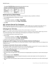
Technical Reference for Garmin NMEA 2000 Products
Page 36
...of motion on -screen instructions to the lowest position. Follow the on a regular basis, calibrate the GBT 10 adapter using your compatible Garmin display device. Move both trim tabs to calibrate the trim tab position. To access the NMEA 2000 configuration menu on the configuration screens.... Configuring the GBT 10 Adapter if the Trim Tab Calibration Selection Is Not Displayed Depending on the version of software loaded on your Garmin marine instrument, the specific configuration options may not be at or near 0% of their full range of the full range....
...of motion on -screen instructions to the lowest position. Follow the on a regular basis, calibrate the GBT 10 adapter using your compatible Garmin display device. Move both trim tabs to calibrate the trim tab position. To access the NMEA 2000 configuration menu on the configuration screens.... Configuring the GBT 10 Adapter if the Trim Tab Calibration Selection Is Not Displayed Depending on the version of software loaded on your Garmin marine instrument, the specific configuration options may not be at or near 0% of their full range of the full range....
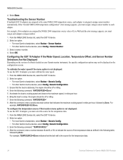
Technical Reference for Garmin NMEA 2000 Products
Page 38
...adapter, you must assign a unique sensor number to a stop; Select an option: • For most Garmin chartplotters, select Review > Generic Config. • For other Garmin marine devices, select Config >Generic Configuration. 3. Enter the following command: "WATERSPEED=0Done" 5. Troubleshooting the Sensor... Number If multiple GST 10 adapters are assigned the NMEA 2000 temperature source value of software loaded on your Garmin marine instrument, the specific configuration options may not be displayed on the configuration screens. Select an option: •...
...adapter, you must assign a unique sensor number to a stop; Select an option: • For most Garmin chartplotters, select Review > Generic Config. • For other Garmin marine devices, select Config >Generic Configuration. 3. Enter the following command: "WATERSPEED=0Done" 5. Troubleshooting the Sensor... Number If multiple GST 10 adapters are assigned the NMEA 2000 temperature source value of software loaded on your Garmin marine instrument, the specific configuration options may not be displayed on the configuration screens. Select an option: •...

Technical Reference for Garmin NMEA 2000 Products
Page 41
... settings. 2. Configuring the GWS 10 if the Filter and Offset Selections Are Not Displayed Depending on the version of software loaded on your Garmin marine instrument, the specific configuration options may stabilize the display. Select Generic Configuration to move or change in increments of... 0.25 second, or 255 to represent the Automatic setting (for Garmin NMEA 2000 Products 37 Enter the following command: "ANGLEFILTER=" 3. While viewing the NMEA 2000 device information, select Config > Wind Angle ...
... settings. 2. Configuring the GWS 10 if the Filter and Offset Selections Are Not Displayed Depending on the version of software loaded on your Garmin marine instrument, the specific configuration options may stabilize the display. Select Generic Configuration to move or change in increments of... 0.25 second, or 255 to represent the Automatic setting (for Garmin NMEA 2000 Products 37 Enter the following command: "ANGLEFILTER=" 3. While viewing the NMEA 2000 device information, select Config > Wind Angle ...
Technical Reference for Garmin NMEA 2000 Products
Page 42
... install a switch? (page 5) Is the NMEA 2000 power cable grounded? NMEA 2000 Checklist Use this checklist to confirm your Garmin products, visit the Garmin Web site at www.garmin.com. Is the NMEA 2000 network connected to power, and is the power balanced correctly on both ends of the NMEA 2000... network? (page 7) Are all drop cables less than 20 ft. (6 m)? (page 8) For the latest free software updates (excluding map data) ...
... install a switch? (page 5) Is the NMEA 2000 power cable grounded? NMEA 2000 Checklist Use this checklist to confirm your Garmin products, visit the Garmin Web site at www.garmin.com. Is the NMEA 2000 network connected to power, and is the power balanced correctly on both ends of the NMEA 2000... network? (page 7) Are all drop cables less than 20 ft. (6 m)? (page 8) For the latest free software updates (excluding map data) ...


