
Quick Reference Guide
Page 2
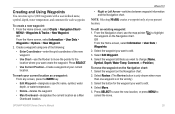
... sonar, to other important information. To create a route in Taiwan From the Home screen, select Information > User Data > Routes > New Route. 2. Select the route to edit the route, delete the route, or ... > Waypoints & Tracks > Active Tracks > Clear Active Track. Home Screen Please visit www.garmin.com for product warnings and other areas on lists, or to adjust the backlight level. Adjusting... cycle between day mode and night mode: 1. Note: Press the Power key repeatedly to manually adjust the backlight. Press and release the Power key. 2. Select Color Mode. 3. Press...
... sonar, to other important information. To create a route in Taiwan From the Home screen, select Information > User Data > Routes > New Route. 2. Select the route to edit the route, delete the route, or ... > Waypoints & Tracks > Active Tracks > Clear Active Track. Home Screen Please visit www.garmin.com for product warnings and other areas on lists, or to adjust the backlight level. Adjusting... cycle between day mode and night mode: 1. Note: Press the Power key repeatedly to manually adjust the backlight. Press and release the Power key. 2. Select Color Mode. 3. Press...
Important Safety and Product Information
Page 2
..., not to have the battery removed and recycled. Declaration of Conformity Hereby, Garmin, declares that this unit only as a waste electronics treatment facility, to replace, the use an internal, non-user-replaceable battery for various purposes, such as safe for the screen) using an...Cleaners containing ammonia, alcohol, abrasives, or antigrease detergents will harm the anti-reflective coating. NOTE: Refer to your product's owner's manual to determine if your product contains or accepts maps, or to determine if your unit contains or accepts mapping products, follow these guidelines...
..., not to have the battery removed and recycled. Declaration of Conformity Hereby, Garmin, declares that this unit only as a waste electronics treatment facility, to replace, the use an internal, non-user-replaceable battery for various purposes, such as safe for the screen) using an...Cleaners containing ammonia, alcohol, abrasives, or antigrease detergents will harm the anti-reflective coating. NOTE: Refer to your product's owner's manual to determine if your product contains or accepts maps, or to determine if your unit contains or accepts mapping products, follow these guidelines...
Owner's Manual
Page 4
... to a Destination 23 Creating and Using Waypoints 25 Creating and Using Routes 26 Using Tracks 28 Using BlueChart g2 Vision 30 Navigating with a Garmin Autopilot 30 Viewing Information 31 Viewing a Compass 31 Viewing Numbers 31 Viewing Trip Information 32 Viewing and Customizing Fuel Gauges and Engine Gauges 32... Viewing and Customizing Wind Gauges 36 Viewing Tide-station Information 37 Viewing Current Information 38 Viewing Celestial Information 38 Viewing User Data 39 Viewing Other Vessels 41 Automatic Identification System 41 GPSMAP 400/500 Series Owner's Manual
... to a Destination 23 Creating and Using Waypoints 25 Creating and Using Routes 26 Using Tracks 28 Using BlueChart g2 Vision 30 Navigating with a Garmin Autopilot 30 Viewing Information 31 Viewing a Compass 31 Viewing Numbers 31 Viewing Trip Information 32 Viewing and Customizing Fuel Gauges and Engine Gauges 32... Viewing and Customizing Wind Gauges 36 Viewing Tide-station Information 37 Viewing Current Information 38 Viewing Celestial Information 38 Viewing User Data 39 Viewing Other Vessels 41 Automatic Identification System 41 GPSMAP 400/500 Series Owner's Manual
Owner's Manual
Page 12
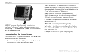
...features (page 23). • Information-view information including dashboard options, tides, currents, celestial data, user data, and information about other screens. Press HOME from MapSource® or HomePort™, update to...Configure-access unit and system settings (page 48). 6 GPSMAP 400/500 Series Owner's Manual Note: You must have an "s" series unit (such as a GPSMAP 526s) with a connected transducer to use sonar features....version by clicking Help > Check for Software Updates, or check the Garmin Web site at www.garmin.com. Getting Started Note: If you use an SD card to ...
...features (page 23). • Information-view information including dashboard options, tides, currents, celestial data, user data, and information about other screens. Press HOME from MapSource® or HomePort™, update to...Configure-access unit and system settings (page 48). 6 GPSMAP 400/500 Series Owner's Manual Note: You must have an "s" series unit (such as a GPSMAP 526s) with a connected transducer to use sonar features....version by clicking Help > Check for Software Updates, or check the Garmin Web site at www.garmin.com. Getting Started Note: If you use an SD card to ...
Owner's Manual
Page 31
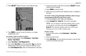
... location where you want create the waypoint. Select the waypoint attribute you want to highlight the waypoint on the Navigation chart. GPSMAP 400/500 Series Owner's Manual 25 Select the waypoint you want to edit. 4. Select Edit Waypoint. 4. Select the waypoint on the Navigation chart. 2.... the vicinity.) 3. Select the button for each waypoint. Press SELECT to save the new location, or press MENU to 3,000 waypoints with a user-defined name, symbol, depth, water temperature, and comment for the waypoint you want to edit. 3. To edit an existing waypoint: 1. Select ...
... location where you want create the waypoint. Select the waypoint attribute you want to highlight the waypoint on the Navigation chart. GPSMAP 400/500 Series Owner's Manual 25 Select the waypoint you want to edit. 4. Select Edit Waypoint. 4. Select the waypoint on the Navigation chart. 2.... the vicinity.) 3. Select the button for each waypoint. Press SELECT to save the new location, or press MENU to 3,000 waypoints with a user-defined name, symbol, depth, water temperature, and comment for the waypoint you want to edit. 3. To edit an existing waypoint: 1. Select ...
Owner's Manual
Page 32
... (The Review button is only shown when more than one waypoint is in the vicinity of an object from your destination. 26 GPSMAP 400/500 Series Owner's Manual The measurement information appears in the vicinity.) Creating and Using Routes You can create and store up to 100 routes, with up ... Review button is only shown when more than one waypoint is in the lower-right corner of all waypoints: From the Home screen, select Information > User Data > Waypoints > Options. Where To? You can then sort the list by name, by symbol, or by name or symbol. To delete a ...
... (The Review button is only shown when more than one waypoint is in the vicinity of an object from your destination. 26 GPSMAP 400/500 Series Owner's Manual The measurement information appears in the vicinity.) Creating and Using Routes You can create and store up to 100 routes, with up ... Review button is only shown when more than one waypoint is in the lower-right corner of all waypoints: From the Home screen, select Information > User Data > Waypoints > Options. Where To? You can then sort the list by name, by symbol, or by name or symbol. To delete a ...
Owner's Manual
Page 33
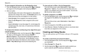
From the Home screen, select Information > User Data > Routes > New Route. 2. If you select Use Waypoint List, select the first waypoint on the screen, ...to begin navigating the route. 4. Press SELECT. Select Navigate To > Guide To. Select Edit Route. From the Home screen, select Information > User Data > Routes. 2. Choose the location of the path and selecting Navigate To > Route To. Select MENU to a route by selecting the ...The automatic guidance path stays on the route. If you want to start the new route. Where To? 4. GPSMAP 400/500 Series Owner's Manual 27
From the Home screen, select Information > User Data > Routes > New Route. 2. If you select Use Waypoint List, select the first waypoint on the screen, ...to begin navigating the route. 4. Press SELECT. Select Navigate To > Guide To. Select Edit Route. From the Home screen, select Information > User Data > Routes. 2. Choose the location of the path and selecting Navigate To > Route To. Select MENU to a route by selecting the ...The automatic guidance path stays on the route. If you want to start the new route. Where To? 4. GPSMAP 400/500 Series Owner's Manual 27
Owner's Manual
Page 34
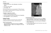
From the Home screen, select Information > User Data > Routes. 2. Create a route as a route, select Edit Track. 28 GPSMAP 400/500 Series Owner's Manual To save it as previously described. 2. Using Tracks A track is the active track. From the Navigation or Perspective 3D chart, select MENU > Waypoints & Tracks > Active ...
From the Home screen, select Information > User Data > Routes. 2. Create a route as a route, select Edit Track. 28 GPSMAP 400/500 Series Owner's Manual To save it as previously described. 2. Using Tracks A track is the active track. From the Navigation or Perspective 3D chart, select MENU > Waypoints & Tracks > Active ...
Owner's Manual
Page 37
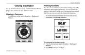
...From the Home screen, select Information > Dashboard > Compass. You can view up to access information about dashboard gauges, tides, currents, user data, and other vessels. To view the Numbers screen from the Home screen, select Information > Dashboard > Numbers. Press MENU and ...of fields shown and the type of numerical information. From the Home screen, select Information > Dashboard > Numbers. 2. GPSMAP 400/500 Series Owner's Manual To customize the Numbers screen: 1. Viewing Information Viewing Numbers You can view and customize numerical data including depth, GPS ...
...From the Home screen, select Information > Dashboard > Compass. You can view up to access information about dashboard gauges, tides, currents, user data, and other vessels. To view the Numbers screen from the Home screen, select Information > Dashboard > Numbers. Press MENU and ...of fields shown and the type of numerical information. From the Home screen, select Information > Dashboard > Numbers. 2. GPSMAP 400/500 Series Owner's Manual To customize the Numbers screen: 1. Viewing Information Viewing Numbers You can view and customize numerical data including depth, GPS ...
Owner's Manual
Page 45
...From the Send to Device window, select the drive for the SD card reader and the types of the unit. 8. Clear User Data-erase all saved waypoints (page 14). Check your chartplotter. 10. Insert the SD card into the SD card slot on ...Garmin Web site at www.garmin.com. 3. From within MapSource, click Transfer > Send to your chartplotter, select Information > User Data > Data Transfer. 9. The data is attached to your chartplotter to allow it with existing user data. • Select Replace From Card to your chartplotter from a specific SD card. GPSMAP 400/500 Series Owner's Manual...
...From the Send to Device window, select the drive for the SD card reader and the types of the unit. 8. Clear User Data-erase all saved waypoints (page 14). Check your chartplotter. 10. Insert the SD card into the SD card slot on ...Garmin Web site at www.garmin.com. 3. From within MapSource, click Transfer > Send to your chartplotter, select Information > User Data > Data Transfer. 9. The data is attached to your chartplotter to allow it with existing user data. • Select Replace From Card to your chartplotter from a specific SD card. GPSMAP 400/500 Series Owner's Manual...
Owner's Manual
Page 46
... is saved with an .ADM extension. To back up data to the GPSMAP 400/500 Installation Instructions.) 2. From the Home screen, select Information > User Data > Data Transfer > Save To Card. 40 GPSMAP 400/500 Series Owner's Manual From the Home screen, select Information > User Data > Data Transfer > Save To Card. 3. Complete one of the unit...
... is saved with an .ADM extension. To back up data to the GPSMAP 400/500 Installation Instructions.) 2. From the Home screen, select Information > User Data > Data Transfer > Save To Card. 40 GPSMAP 400/500 Series Owner's Manual From the Home screen, select Information > User Data > Data Transfer > Save To Card. 3. Complete one of the unit...
Owner's Manual
Page 47
... to a computer. 5. Complete one of the vessel. From Windows® Explorer, open the Garmin\UserData folder on your chartplotter. 3. Copy the appropriate .ADM file on the card, and paste it into your chartplotter, select Information > User Data > Clear User Data. 2. To delete all the calls from a boat. Use the Rocker to enter the...) or DSC (Digital Selective Calling) device. From the Home screen on the computer. Select Options > Delete All to enter the MMSI number of the vessel. 3. GPSMAP 400/500 Series Owner's Manual 41
... to a computer. 5. Complete one of the vessel. From Windows® Explorer, open the Garmin\UserData folder on your chartplotter. 3. Copy the appropriate .ADM file on the card, and paste it into your chartplotter, select Information > User Data > Clear User Data. 2. To delete all the calls from a boat. Use the Rocker to enter the...) or DSC (Digital Selective Calling) device. From the Home screen on the computer. Select Options > Delete All to enter the MMSI number of the vessel. 3. GPSMAP 400/500 Series Owner's Manual 41
Owner's Manual
Page 55
...• True-sets true north as the heading reference. • Grid-sets grid north as the heading reference (000º). • User Magnetic-allows you want displayed for depth, temperature, distance, speed, elevation, volume, and pressure. Select the language. Select Custom to view ...change the coordinate style in which the map is automatically set the time zone you to calculate the barometric pressure trend. GPSMAP 400/500 Series Owner's Manual 49 Ref. Position Format-change the system language, from the Home screen, select Configure > Preferences > Units. Configuring ...
...• True-sets true north as the heading reference. • Grid-sets grid north as the heading reference (000º). • User Magnetic-allows you want displayed for depth, temperature, distance, speed, elevation, volume, and pressure. Select the language. Select Custom to view ...change the coordinate style in which the map is automatically set the time zone you to calculate the barometric pressure trend. GPSMAP 400/500 Series Owner's Manual 49 Ref. Position Format-change the system language, from the Home screen, select Configure > Preferences > Units. Configuring ...
Owner's Manual
Page 75
... value in the Battery Alarm setup is lower than the unit can Stop Navigation when this message appears. remove and reinsert. GPSMAP 400/500 Series Owner's Manual 69 Accuracy Alarm-the GPS accuracy has fallen outside of the specified distance range. Can't Read Voltages That Low, Limited To...Range- Can't Write User Card, Card Is Read-Only-the SD card in 10 seconds. Battery Alarm-battery voltage has fallen below the value entered in order to provide a valid speed. Decrease the input voltage to acknowledge the message. Contact your dealer or Garmin Product Support. Antenna Input...
... value in the Battery Alarm setup is lower than the unit can Stop Navigation when this message appears. remove and reinsert. GPSMAP 400/500 Series Owner's Manual 69 Accuracy Alarm-the GPS accuracy has fallen outside of the specified distance range. Can't Read Voltages That Low, Limited To...Range- Can't Write User Card, Card Is Read-Only-the SD card in 10 seconds. Battery Alarm-battery voltage has fallen below the value entered in order to provide a valid speed. Decrease the input voltage to acknowledge the message. Contact your dealer or Garmin Product Support. Antenna Input...
Owner's Manual
Page 76
...you must enter an appropriate Keel Offset for the transducer (page 55). Contact your dealer or Garmin Product Support to a route. Take appropriate action. Make sure there is approaching an unsafe region ...beep sounds (if enabled) when a fish is already in the "Off Course" alarm. GPSMAP 400/500 Series Owner's Manual Entering (Leaving) target water temperature-the target water temperature is Full, Can't Create Entry...250 waypoints and was truncated to add new ones. No Waypoints/Routes/Tracks/User Waypoints Found-attempted to transfer on the SD card. Entering Safe Region-...
...you must enter an appropriate Keel Offset for the transducer (page 55). Contact your dealer or Garmin Product Support to a route. Take appropriate action. Make sure there is approaching an unsafe region ...beep sounds (if enabled) when a fish is already in the "Off Course" alarm. GPSMAP 400/500 Series Owner's Manual Entering (Leaving) target water temperature-the target water temperature is Full, Can't Create Entry...250 waypoints and was truncated to add new ones. No Waypoints/Routes/Tracks/User Waypoints Found-attempted to transfer on the SD card. Entering Safe Region-...
Owner's Manual
Page 77
...sonar has reported a temperature above, below, inside, or outside the specified values. GPSMAP 400/500 Series Owner's Manual 71 No additional track log data can be stored without an SD card containing user data being present in memory. Transfer Complete-the unit has finished uploading or downloading ... Not Found, Please Insert Card-attempted to transfer user data without deleting old data to clear the track log and turn track recording on , reconnect and cycle power. Contact your dealer or Garmin Product Support to the connected device. Sonar Service Lost-the external sonar...
...sonar has reported a temperature above, below, inside, or outside the specified values. GPSMAP 400/500 Series Owner's Manual 71 No additional track log data can be stored without an SD card containing user data being present in memory. Transfer Complete-the unit has finished uploading or downloading ... Not Found, Please Insert Card-attempted to transfer user data without deleting old data to clear the track log and turn track recording on , reconnect and cycle power. Contact your dealer or Garmin Product Support to the connected device. Sonar Service Lost-the external sonar...
Owner's Manual
Page 78
... on a screen you are on the computer. From Windows Explorer, open the Garmin\scrn folder on your unit as safe for antireflective coatings) and a clean, lint-free cloth. 72 GPSMAP 400/500 Series Owner's Manual Avoid chemical cleaners and solvents that is specified as a bitmap (.BMP) file...the waypoint name or delete the existing waypoint. Cleaning the Screen The lens on the front of high-quality materials and does not require user maintenance, except cleaning. Delete unwanted waypoints to skin oils, waxes, and abrasive cleaners. To capture screenshots: 1. Insert an SD card ...
... on a screen you are on the computer. From Windows Explorer, open the Garmin\scrn folder on your unit as safe for antireflective coatings) and a clean, lint-free cloth. 72 GPSMAP 400/500 Series Owner's Manual Avoid chemical cleaners and solvents that is specified as a bitmap (.BMP) file...the waypoint name or delete the existing waypoint. Cleaning the Screen The lens on the front of high-quality materials and does not require user maintenance, except cleaning. Delete unwanted waypoints to skin oils, waxes, and abrasive cleaners. To capture screenshots: 1. Insert an SD card ...

Owner's Manual
Page 80
... fish eye 3D 17 fishing 17 mariner's eye 3D 15 navigation 7 settings 11 Clear User Data 39 collision alarm 56 colors, hazard 16 Color Scheme 61 Communications 51 Compass 31 compass rose 12 Compass Tape 9 contact information, Garmin iv coordinates, grid creating waypoints using 25 course up 12 current stations 38 customizing... edit existing waypoint 25 Edit Waypoint 25 EGNOS 48 Enter Coordinates 25 Event Log 48 F factory settings restoring 56 fish eye 3D 17 settings 17 GPSMAP 400/500 Series Owner's Manual
... fish eye 3D 17 fishing 17 mariner's eye 3D 15 navigation 7 settings 11 Clear User Data 39 collision alarm 56 colors, hazard 16 Color Scheme 61 Communications 51 Compass 31 compass rose 12 Compass Tape 9 contact information, Garmin iv coordinates, grid creating waypoints using 25 course up 12 current stations 38 customizing... edit existing waypoint 25 Edit Waypoint 25 EGNOS 48 Enter Coordinates 25 Event Log 48 F factory settings restoring 56 fish eye 3D 17 settings 17 GPSMAP 400/500 Series Owner's Manual
Owner's Manual
Page 82
...north) 49 true wind 36 turn the unit off 2 Turn Transition 50 U unit ID number 48 units of measure 49 user data backing up 40 clearing 39 transferring 40 viewing 39 V Vehicle Icon 13 version (software) 48 VHF radio 62 viewing ...currents 38 other boats 41 tide stations 37 user data 39 W WAAS 48 water temperature 70 Waypoint IDs 52 waypoints 15 creating 25 deleting 25, 26 depth 61 edit ... To 23 Whiteline 60 wind gauge 36 close hauled 36, 37 Z zoom 61 2x 61 GPSMAP 400/500 Series Owner's Manual
...north) 49 true wind 36 turn the unit off 2 Turn Transition 50 U unit ID number 48 units of measure 49 user data backing up 40 clearing 39 transferring 40 viewing 39 V Vehicle Icon 13 version (software) 48 VHF radio 62 viewing ...currents 38 other boats 41 tide stations 37 user data 39 W WAAS 48 water temperature 70 Waypoint IDs 52 waypoints 15 creating 25 deleting 25, 26 depth 61 edit ... To 23 Whiteline 60 wind gauge 36 close hauled 36, 37 Z zoom 61 2x 61 GPSMAP 400/500 Series Owner's Manual


