
Owner's Manual
Page 6
... considered as a primary reference for VFR navigation. Pilots using any purpose requiring precise measurement of the terrain data. Garmin GPSMAP 695/696 Owner's Manual 190-00919-00 Rev. G WARNING: The altitude calculated by GPSMAP 695/696 GPS receiver is not certified for any outdated database do so entirely at their own risk. WARNING: The indicators represented on...
... considered as a primary reference for VFR navigation. Pilots using any purpose requiring precise measurement of the terrain data. Garmin GPSMAP 695/696 Owner's Manual 190-00919-00 Rev. G WARNING: The altitude calculated by GPSMAP 695/696 GPS receiver is not certified for any outdated database do so entirely at their own risk. WARNING: The indicators represented on...

Owner's Manual
Page 13
G Garmin GPSMAP 695/696 Owner's Manual i Table of Contents SECTION 1 OVERVIEW...1 1.1 Unit Overview...1 Battery Care and Charging...2 Turning the Unit On/Off...4 GPS Receiver Status...6 1.2 GPSMAP 695/696 Controls 8 1.3 Accessing System Functionality 10 Menus...10 Data Entry...11 Pages...13 Main Page Softkeys...18 Flight ... Units...29 Date & Time...30 Position...30 Interface...31 Alarms...31 Power...32 Setting Airport Criteria...33 Utilities...34 SECTION 2 GPS NAVIGATION 35 2.1 Introduction...35 Data Bar Fields...36 Compass Arc...38 2.2 Panel...40 Changing the CDI Scale...41 Setting the ...
G Garmin GPSMAP 695/696 Owner's Manual i Table of Contents SECTION 1 OVERVIEW...1 1.1 Unit Overview...1 Battery Care and Charging...2 Turning the Unit On/Off...4 GPS Receiver Status...6 1.2 GPSMAP 695/696 Controls 8 1.3 Accessing System Functionality 10 Menus...10 Data Entry...11 Pages...13 Main Page Softkeys...18 Flight ... Units...29 Date & Time...30 Position...30 Interface...31 Alarms...31 Power...32 Setting Airport Criteria...33 Utilities...34 SECTION 2 GPS NAVIGATION 35 2.1 Introduction...35 Data Bar Fields...36 Compass Arc...38 2.2 Panel...40 Changing the CDI Scale...41 Setting the ...

Owner's Manual
Page 20
...GPS Navigation Overview If you do not want to use the unit, but you can put the unit into Charge Mode. TURNING THE UNIT ON/OFF Press and hold the POWER Button. To ensure proper initialization, the GPSMAP 695/696 is shipped from the factory in the world. 4 Garmin GPSMAP 695/696... Owner's Manual 190-00919-00 Rev. Connect the unit to "find itself" anywhere in AutoLocate mode, which allows the receiver to an external power supply. G The GPSMAP 695/696 retains the ...
...GPS Navigation Overview If you do not want to use the unit, but you can put the unit into Charge Mode. TURNING THE UNIT ON/OFF Press and hold the POWER Button. To ensure proper initialization, the GPSMAP 695/696 is shipped from the factory in the world. 4 Garmin GPSMAP 695/696... Owner's Manual 190-00919-00 Rev. Connect the unit to "find itself" anywhere in AutoLocate mode, which allows the receiver to an external power supply. G The GPSMAP 695/696 retains the ...

Owner's Manual
Page 22
... fix Constellation Diagram PRN Number 45° Above Horizon Horizon Receiver Status Signal Strength Bar PRN Number GPS Status (Info Page) Appendices Index 6 Garmin GPSMAP 695/696 Owner's Manual 190-00919-00 Rev. G Overview GPS Navigation Additional Features Hazard Avoidance Flight Planning Overview GPS RECEIVER STATUS The receiver status field on the INFO Page displays one of the following...
... fix Constellation Diagram PRN Number 45° Above Horizon Horizon Receiver Status Signal Strength Bar PRN Number GPS Status (Info Page) Appendices Index 6 Garmin GPSMAP 695/696 Owner's Manual 190-00919-00 Rev. G Overview GPS Navigation Additional Features Hazard Avoidance Flight Planning Overview GPS RECEIVER STATUS The receiver status field on the INFO Page displays one of the following...

Owner's Manual
Page 23
...data (collected continuously from the satellites) and last known position to poor satellite coverage or installation problems. As the GPS receiver locks onto satellites, a signal strength bar is displayed for each satellite in view, with the appropriate satellite PRN...point shows the position directly overhead. G Garmin GPSMAP 695/696 Owner's Manual 7 The progress of acquiring a 3D differential GPS solution, '3D GPS Location' is shown in view are shown at their respective positions on a satellite constellation diagram. When the receiver is in the process of satellite acquisition...
...data (collected continuously from the satellites) and last known position to poor satellite coverage or installation problems. As the GPS receiver locks onto satellites, a signal strength bar is displayed for each satellite in view, with the appropriate satellite PRN...point shows the position directly overhead. G Garmin GPSMAP 695/696 Owner's Manual 7 The progress of acquiring a 3D differential GPS solution, '3D GPS Location' is shown in view are shown at their respective positions on a satellite constellation diagram. When the receiver is in the process of satellite acquisition...

Owner's Manual
Page 76
.../696 will choose the most appropriate identifier based on the current position and phase of flight planning and navigation. G Overview GPS Navigation Additional Features Hazard Avoidance Flight Planning GPS Navigation 2.5 WAYPOINTS The Waypoint (WPT) Page provides airport and waypoint information. A direct-to navigation... pilotentered positions, and are used for pilot-controlled lighting) • COM Availability: TX (transmit only), RX (receive only), PT (part time), * (additional information available) Appendices Index 60 Garmin GPSMAP 695/696 Owner's Manual 190-00919-00 Rev.
.../696 will choose the most appropriate identifier based on the current position and phase of flight planning and navigation. G Overview GPS Navigation Additional Features Hazard Avoidance Flight Planning GPS Navigation 2.5 WAYPOINTS The Waypoint (WPT) Page provides airport and waypoint information. A direct-to navigation... pilotentered positions, and are used for pilot-controlled lighting) • COM Availability: TX (transmit only), RX (receive only), PT (part time), * (additional information available) Appendices Index 60 Garmin GPSMAP 695/696 Owner's Manual 190-00919-00 Rev.

Owner's Manual
Page 122
... (designated by the letter Z) is displayed using colors corresponding to the radar receiver. Precipitation intensity is the amount of Z). For example, it is not possible ...is unknown. An individual NEXRAD site cannot depict high altitude storms at the minimum antenna elevation angle. Overview GPS Navigation Hazard Avoidance NEXRAD Limitations Certain limitations exist regarding the NEXRAD radar displays. NEXRAD Intensity Colors are listed for... Avoidance Flight Planning Appendices Index RADAR Legend NEXRAD Data 106 Garmin GPSMAP 695/696 Owner's Manual 190-00919-00 Rev.
... (designated by the letter Z) is displayed using colors corresponding to the radar receiver. Precipitation intensity is the amount of Z). For example, it is not possible ...is unknown. An individual NEXRAD site cannot depict high altitude storms at the minimum antenna elevation angle. Overview GPS Navigation Hazard Avoidance NEXRAD Limitations Certain limitations exist regarding the NEXRAD radar displays. NEXRAD Intensity Colors are listed for... Avoidance Flight Planning Appendices Index RADAR Legend NEXRAD Data 106 Garmin GPSMAP 695/696 Owner's Manual 190-00919-00 Rev.

Owner's Manual
Page 140
...Key. 5) Turn or move the FMS Joystick to the GPSMAP 695/696 through a power/data cable. Overview GPS Navigation Additional Features Hazard Avoidance Flight Planning Hazard Avoidance DATA LINK WEATHER (FIS-B) The GPSMAP 695/696 is a receive-only data link radio with the GDL 39 data link ...NEXRAD (Regional and CONUS (Combined)), AIRMETs, SIGMETs, PIREPs, and Winds and Temperatures Aloft. Appendices Index 124 Garmin GPSMAP 695/696 Owner's Manual 190-00919-00 Rev. To receive FIS-B weather information, the GDL 39 must be affected by Ground Based Transceivers (GBTs) over GDL FIS-B...
...Key. 5) Turn or move the FMS Joystick to the GPSMAP 695/696 through a power/data cable. Overview GPS Navigation Additional Features Hazard Avoidance Flight Planning Hazard Avoidance DATA LINK WEATHER (FIS-B) The GPSMAP 695/696 is a receive-only data link radio with the GDL 39 data link ...NEXRAD (Regional and CONUS (Combined)), AIRMETs, SIGMETs, PIREPs, and Winds and Temperatures Aloft. Appendices Index 124 Garmin GPSMAP 695/696 Owner's Manual 190-00919-00 Rev. To receive FIS-B weather information, the GDL 39 must be affected by Ground Based Transceivers (GBTs) over GDL FIS-B...

Owner's Manual
Page 141
The default is required to receive FIS-B weather information. No pilot action is 'AUTO' which will use XM over GDL FIS-B if both are updated regularly and may take approximately ten .... Weather product status can be viewed on the dedicated Weather Page,or the Data Link Page from the Tools menu. G Garmin GPSMAP 695/696 Owner's Manual 125 Appendices Index 190-00919-00 Rev. Overview GPS Navigation Flight Planning Hazard Avoidance Additional Features Hazard Avoidance Or 1) From the Weather Page press SETUP Softkey. 2) Turn or...
The default is required to receive FIS-B weather information. No pilot action is 'AUTO' which will use XM over GDL FIS-B if both are updated regularly and may take approximately ten .... Weather product status can be viewed on the dedicated Weather Page,or the Data Link Page from the Tools menu. G Garmin GPSMAP 695/696 Owner's Manual 125 Appendices Index 190-00919-00 Rev. Overview GPS Navigation Flight Planning Hazard Avoidance Additional Features Hazard Avoidance Or 1) From the Weather Page press SETUP Softkey. 2) Turn or...

Owner's Manual
Page 142
... product is displayed. The broadcast interval represents the interval at 15 minute intervals for 1 hour 5 8 hours As Available 10 Appendices Index 126 Garmin GPSMAP 695/696 Owner's Manual 190-00919-00 Rev. G If, for clear air Broadcast Interval (Minutes) 15 60 minutes As Available 2.5 8 hours 1 minute... of the product age displayed changes to yellow. Overview GPS Navigation Additional Features Hazard Avoidance Flight Planning Hazard Avoidance When a FIS-B weather product is active on a map, the age of the data is received by the GDL 39. Weather products are broadcast at...
... product is displayed. The broadcast interval represents the interval at 15 minute intervals for 1 hour 5 8 hours As Available 10 Appendices Index 126 Garmin GPSMAP 695/696 Owner's Manual 190-00919-00 Rev. G If, for clear air Broadcast Interval (Minutes) 15 60 minutes As Available 2.5 8 hours 1 minute... of the product age displayed changes to yellow. Overview GPS Navigation Additional Features Hazard Avoidance Flight Planning Hazard Avoidance When a FIS-B weather product is active on a map, the age of the data is received by the GDL 39. Weather products are broadcast at...

Owner's Manual
Page 144
...snow, wet hail, and rain. • NEXRAD base reflectivity is displayed using colors corresponding to the radar receiver. Appendices Index 128 Garmin GPSMAP 695/696 Owner's Manual 190-00919-00 Rev. rain). Precipitation intensity is sampled at close ranges, and has no... of transmitted power returned to the dBZ values. The dBZ values increase as returned signal strength increases. G Overview GPS Navigation Additional Features Hazard Avoidance Flight Planning Hazard Avoidance NEXRAD Abnormalities There are possible abnormalities regarding the NEXRAD radar displays....
...snow, wet hail, and rain. • NEXRAD base reflectivity is displayed using colors corresponding to the radar receiver. Appendices Index 128 Garmin GPSMAP 695/696 Owner's Manual 190-00919-00 Rev. rain). Precipitation intensity is sampled at close ranges, and has no... of transmitted power returned to the dBZ values. The dBZ values increase as returned signal strength increases. G Overview GPS Navigation Additional Features Hazard Avoidance Flight Planning Hazard Avoidance NEXRAD Abnormalities There are possible abnormalities regarding the NEXRAD radar displays....

Owner's Manual
Page 157
... is not subject to determine terrain and obstacle proximity. They should be used MSL altitude source. The GPSMAP 695/696 GPS receiver provides the horizontal position and altitude of terrain and obstructions relative to the aircraft position and altitude with ...aircraft. The Terrain Page displays altitudes of the aircraft. G Garmin GPSMAP 695/696 Owner's Manual 141 Appendices Index It is always "ahead" of proximity to a database that normally affect pressure altitude sensors. Aircraft GPS altitude is intended only to navigate or maneuver around terrain. In...
... is not subject to determine terrain and obstacle proximity. They should be used MSL altitude source. The GPSMAP 695/696 GPS receiver provides the horizontal position and altitude of terrain and obstructions relative to the aircraft position and altitude with ...aircraft. The Terrain Page displays altitudes of the aircraft. G Garmin GPSMAP 695/696 Owner's Manual 141 Appendices Index It is always "ahead" of proximity to a database that normally affect pressure altitude sensors. Aircraft GPS altitude is intended only to navigate or maneuver around terrain. In...
Owner's Manual
Page 164
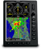
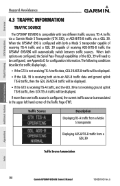
... Source Description Displaying TIS-A traffic from a GDL 39 Traffic Source Annunciation Appendices Index 148 Garmin GPSMAP 695/696 Owner's Manual 190-00919-00 Rev. Overview GPS Navigation Additional Features Hazard Avoidance Flight Planning Hazard Avoidance 4.3 TRAFFIC INFORMATION TRAFFIC SOURCE The GPSMAP 695/696 is not receiving ground uplink TIS-B traffic, then GTX TIS-A traffic will be displayed. G
... Source Description Displaying TIS-A traffic from a GDL 39 Traffic Source Annunciation Appendices Index 148 Garmin GPSMAP 695/696 Owner's Manual 190-00919-00 Rev. Overview GPS Navigation Additional Features Hazard Avoidance Flight Planning Hazard Avoidance 4.3 TRAFFIC INFORMATION TRAFFIC SOURCE The GPSMAP 695/696 is not receiving ground uplink TIS-B traffic, then GTX TIS-A traffic will be displayed. G

Owner's Manual
Page 166
...TIS-A audio alerts are available: • "Traffic"-TIS-A traffic alert received. • "Traffic Not Available"-TIS-A service is generated. Adjusting alert ...a single aircraft remains on the screen, a new audio alert is alerted audibly. Appendices Index 150 Garmin GPSMAP 695/696 Owner's Manual 190-00919-00 Rev. If a second (or more) aircraft appears on the TIS-A.../696 screen increases from one scan to the next. Limiting Traffic Advisories only reduces the "nuisance" alerting due to exit. Overview GPS Navigation Additional Features Hazard Avoidance Flight Planning Hazard ...
...TIS-A audio alerts are available: • "Traffic"-TIS-A traffic alert received. • "Traffic Not Available"-TIS-A service is generated. Adjusting alert ...a single aircraft remains on the screen, a new audio alert is alerted audibly. Appendices Index 150 Garmin GPSMAP 695/696 Owner's Manual 190-00919-00 Rev. If a second (or more) aircraft appears on the TIS-A.../696 screen increases from one scan to the next. Limiting Traffic Advisories only reduces the "nuisance" alerting due to exit. Overview GPS Navigation Additional Features Hazard Avoidance Flight Planning Hazard ...

Owner's Manual
Page 169
... participating. ADS-B In refers to the capability to transmit ADS-B information. G Garmin GPSMAP 695/696 Owner's Manual 153 Index Overview GPS Navigation Hazard Avoidance DATA LINK TRAFFIC (GDL 39) The GDL 39 is designed to receive, process, and output traffic (ADS-B air-to-air, and TIS-B traffic... information), and weather (Flight Information Service-Broadcast (FIS-B)) information to the GPSMAP 695/696 through a power/data cable. GPS 1090 ES UAT RADAR Composite Flight ...
... participating. ADS-B In refers to the capability to transmit ADS-B information. G Garmin GPSMAP 695/696 Owner's Manual 153 Index Overview GPS Navigation Hazard Avoidance DATA LINK TRAFFIC (GDL 39) The GDL 39 is designed to receive, process, and output traffic (ADS-B air-to-air, and TIS-B traffic... information), and weather (Flight Information Service-Broadcast (FIS-B)) information to the GPSMAP 695/696 through a power/data cable. GPS 1090 ES UAT RADAR Composite Flight ...

Owner's Manual
Page 170
... the GDL 39 receives traffic information directly from any ADS-B Out aircraft within 15 nm lateral and 3,500' vertical of the ADS-B participating aircraft is within range as well as ADS-B nonparticipating aircraft. Therefore, Appendices Index 154 Garmin GPSMAP 695/696 Owner's Manual 190...compliant ADS-B Out capability in the broadcast. TIS-B traffic information includes non-participating aircraft detected by the GBT. Overview GPS Navigation Additional Features Hazard Avoidance Flight Planning Hazard Avoidance to the capability to as the rebroadcast of ADS-B information from any...
... the GDL 39 receives traffic information directly from any ADS-B Out aircraft within 15 nm lateral and 3,500' vertical of the ADS-B participating aircraft is within range as well as ADS-B nonparticipating aircraft. Therefore, Appendices Index 154 Garmin GPSMAP 695/696 Owner's Manual 190...compliant ADS-B Out capability in the broadcast. TIS-B traffic information includes non-participating aircraft detected by the GBT. Overview GPS Navigation Additional Features Hazard Avoidance Flight Planning Hazard Avoidance to the capability to as the rebroadcast of ADS-B information from any...

Owner's Manual
Page 171
... stations, traffic may not identify it as an ADS-B participating aircraft. Due to be present that the aircraft has 978 MHz receive capability in order to lack of the ATC radar coverage area are invisible to see and avoid other aircraft. Or 1) From ... displayed. Since the GDL 39 is not represented on the display. G Garmin GPSMAP 695/696 Owner's Manual 155 Overview GPS Navigation Flight Planning Hazard Avoidance Additional Features Hazard Avoidance TIS-B traffic may be displayed with a qualifying GPS and 1090 ES transponder, a GBT may be identified as an ADS-B ...
... stations, traffic may not identify it as an ADS-B participating aircraft. Due to be present that the aircraft has 978 MHz receive capability in order to lack of the ATC radar coverage area are invisible to see and avoid other aircraft. Or 1) From ... displayed. Since the GDL 39 is not represented on the display. G Garmin GPSMAP 695/696 Owner's Manual 155 Overview GPS Navigation Flight Planning Hazard Avoidance Additional Features Hazard Avoidance TIS-B traffic may be displayed with a qualifying GPS and 1090 ES transponder, a GBT may be identified as an ADS-B ...

Owner's Manual
Page 172
... right corner of the Map Page. If the GDL 39 is annunciated in displaying the relative altitude of received traffic information. Appendices Index 156 Garmin GPSMAP 695/696 Owner's Manual 190-00919-00 Rev. Overview GPS Navigation Additional Features Hazard Avoidance Flight Planning Hazard Avoidance SYSTEM STATUS The traffic system status is used onboard a pressurized...
... right corner of the Map Page. If the GDL 39 is annunciated in displaying the relative altitude of received traffic information. Appendices Index 156 Garmin GPSMAP 695/696 Owner's Manual 190-00919-00 Rev. Overview GPS Navigation Additional Features Hazard Avoidance Flight Planning Hazard Avoidance SYSTEM STATUS The traffic system status is used onboard a pressurized...

Owner's Manual
Page 228
... Data Format field highlighted, turn the FMS Joystick to a Garmin panelmounted GPS receiver. Overview GPS Navigation Additional Features Hazard Avoidance Flight Planning Interface Setup (Main Menu) Serial Data Formats • Garmin Data Transfer-the proprietary format used to exchange data with a PC, Garmin GDL 39, or another Garmin GPSMAP 695/696. • NMEA In/NMEA Out-transmits NMEA position...
... Data Format field highlighted, turn the FMS Joystick to a Garmin panelmounted GPS receiver. Overview GPS Navigation Additional Features Hazard Avoidance Flight Planning Interface Setup (Main Menu) Serial Data Formats • Garmin Data Transfer-the proprietary format used to exchange data with a PC, Garmin GDL 39, or another Garmin GPSMAP 695/696. • NMEA In/NMEA Out-transmits NMEA position...

Owner's Manual
Page 276
... Expiration 179 Range 173 Fuel Flow 90 G GBT 154 GDL 39 21, 124, 126, 148, 153, 163, 164 GPS Receiver Status 6 Ground Based Transceivers 154 GTX 330 213 GXM 40 antenna connecting 210 H Heading Line 230 Horizontal Situation Indicator ( ... IMPORT 23, 95, 205 Interface 31 J Jeppesen database updates 197 L Legends 139 limited warranty 255 Loss of GPS 195 M Map Detail 54 Orientation 47 Panning 50 Range 48 Symbols 54 MAP Page Defaults 139 Map Range 48 MapSource... Nearest Information 64 NEXRAD 127, 128 NMEA 211, 212, 213 O Obstacles 142 Index-2 Garmin GPSMAP 695/696 Owner's Manual 190-00919-00 Rev.
... Expiration 179 Range 173 Fuel Flow 90 G GBT 154 GDL 39 21, 124, 126, 148, 153, 163, 164 GPS Receiver Status 6 Ground Based Transceivers 154 GTX 330 213 GXM 40 antenna connecting 210 H Heading Line 230 Horizontal Situation Indicator ( ... IMPORT 23, 95, 205 Interface 31 J Jeppesen database updates 197 L Legends 139 limited warranty 255 Loss of GPS 195 M Map Detail 54 Orientation 47 Panning 50 Range 48 Symbols 54 MAP Page Defaults 139 Map Range 48 MapSource... Nearest Information 64 NEXRAD 127, 128 NMEA 211, 212, 213 O Obstacles 142 Index-2 Garmin GPSMAP 695/696 Owner's Manual 190-00919-00 Rev.


