
Owner's Manual
Page 3
OVERVIEW GPS NAVIGATION FLIGHT PLANNING HAZARD AVOIDANCE ADDITIONAL FEATURES APPENDICES INDEX
OVERVIEW GPS NAVIGATION FLIGHT PLANNING HAZARD AVOIDANCE ADDITIONAL FEATURES APPENDICES INDEX

Owner's Manual
Page 6
... intended only as an aid for appropriate minimum clearance altitudes. Garmin is only to current aeronautical charts for terrain avoidance and is NOT intended to enhance situational awareness. WARNING: The altitude calculated by GPSMAP 695/696 GPS receiver is obtained from the instruments in applications requiring a certified terrain awareness system. Databases used for... refer to be used as an aid for vertical navigation. The Terrain Proximity feature is not able to ensure that the information remains current. Garmin GPSMAP 695/696 Owner's Manual 190-00919-00 Rev.
... intended only as an aid for appropriate minimum clearance altitudes. Garmin is only to current aeronautical charts for terrain avoidance and is NOT intended to enhance situational awareness. WARNING: The altitude calculated by GPSMAP 695/696 GPS receiver is obtained from the instruments in applications requiring a certified terrain awareness system. Databases used for... refer to be used as an aid for vertical navigation. The Terrain Proximity feature is not able to ensure that the information remains current. Garmin GPSMAP 695/696 Owner's Manual 190-00919-00 Rev.

Owner's Manual
Page 7
... data link weather product may be significantly older than the indicated weather product age. Portions of the Garmin GPSMAP 695/696 utilize GPS as with in , near, or around areas of hazardous weather. Information contained with all NAVAIDs, information presented by the... accuracy and performance of all GPS equipment. WARNING: For safety reasons, GPSMAP 695/696 operational procedures must be misused or misinterpreted and, therefore, become unsafe. 190-00919-00 Rev. The GPS system is subject to see and avoid other aircraft. G Garmin GPSMAP 695/696 Owner's Manual Due to lack...
... data link weather product may be significantly older than the indicated weather product age. Portions of the Garmin GPSMAP 695/696 utilize GPS as with in , near, or around areas of hazardous weather. Information contained with all NAVAIDs, information presented by the... accuracy and performance of all GPS equipment. WARNING: For safety reasons, GPSMAP 695/696 operational procedures must be misused or misinterpreted and, therefore, become unsafe. 190-00919-00 Rev. The GPS system is subject to see and avoid other aircraft. G Garmin GPSMAP 695/696 Owner's Manual Due to lack...

Owner's Manual
Page 13
G Garmin GPSMAP 695/696 Owner's Manual i Table of Contents SECTION 1 OVERVIEW...1 1.1 Unit Overview...1 Battery Care and Charging...2 Turning the Unit On/Off...4 GPS Receiver Status...6 1.2 GPSMAP 695/696 Controls 8 1.3 Accessing System Functionality 10 Menus...10 Data Entry...11 Pages...13 Main Page Softkeys...18 Flight ...28 Units...29 Date & Time...30 Position...30 Interface...31 Alarms...31 Power...32 Setting Airport Criteria...33 Utilities...34 SECTION 2 GPS NAVIGATION 35 2.1 Introduction...35 Data Bar Fields...36 Compass Arc...38 2.2 Panel...40 Changing the CDI Scale...41 Setting the ...
G Garmin GPSMAP 695/696 Owner's Manual i Table of Contents SECTION 1 OVERVIEW...1 1.1 Unit Overview...1 Battery Care and Charging...2 Turning the Unit On/Off...4 GPS Receiver Status...6 1.2 GPSMAP 695/696 Controls 8 1.3 Accessing System Functionality 10 Menus...10 Data Entry...11 Pages...13 Main Page Softkeys...18 Flight ...28 Units...29 Date & Time...30 Position...30 Interface...31 Alarms...31 Power...32 Setting Airport Criteria...33 Utilities...34 SECTION 2 GPS NAVIGATION 35 2.1 Introduction...35 Data Bar Fields...36 Compass Arc...38 2.2 Panel...40 Changing the CDI Scale...41 Setting the ...
Owner's Manual
Page 15
... Operation...195 Resetting the Unit...195 Loss of GPS Position...195 Hazard Display with Loss of GPS Position 196 SD Card Use and Databases 197 SD Card Use...197 GPSMAP 695/696 Databases 198 Updating GPSMAP 695/696 Databases 202 Exporting Track Logs and User Waypoints ...205 Importing/Exporting Flight Plans 205 Installation & Interfacing Information 207 Connecting the Power/Data Cable 207 Connecting to a Garmin...
... Operation...195 Resetting the Unit...195 Loss of GPS Position...195 Hazard Display with Loss of GPS Position 196 SD Card Use and Databases 197 SD Card Use...197 GPSMAP 695/696 Databases 198 Updating GPSMAP 695/696 Databases 202 Exporting Track Logs and User Waypoints ...205 Importing/Exporting Flight Plans 205 Installation & Interfacing Information 207 Connecting the Power/Data Cable 207 Connecting to a Garmin...
Owner's Manual
Page 16
...256 Weather Data Warranty...257 SiriusXM Satellite Radio Service Agreement 258 FCC Compliance...258 Industry Canada Compliance 258 Index...Index-1 iv Garmin GPSMAP 695/696 Owner's Manual 190-00919-00 Rev. G Table of Contents Connecting to a Computer 209 Information about USB Drivers 210 Using... xImage for Customized Waypoint Symbols 210 Connecting the GXM 40 Antenna (GPSMAP 696 210 Interfacing...211 Connecting to a GTX 330 Mode S Transponder 213 Connecting to a GDL 39...214 Using an external GPS Antenna (Optional 219 General TIS-A Information 221 TIS-A vs.
...256 Weather Data Warranty...257 SiriusXM Satellite Radio Service Agreement 258 FCC Compliance...258 Industry Canada Compliance 258 Index...Index-1 iv Garmin GPSMAP 695/696 Owner's Manual 190-00919-00 Rev. G Table of Contents Connecting to a Computer 209 Information about USB Drivers 210 Using... xImage for Customized Waypoint Symbols 210 Connecting the GXM 40 Antenna (GPSMAP 696 210 Interfacing...211 Connecting to a GTX 330 Mode S Transponder 213 Connecting to a GDL 39...214 Using an external GPS Antenna (Optional 219 General TIS-A Information 221 TIS-A vs.
Owner's Manual
Page 17
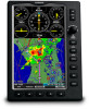
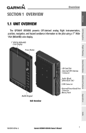
... avoidance information to the pilot using a 7" Wide VGA (800x480) color display. 7" WVGA (800x480) Color Display Power Button Backlit Keypad Unit Overview SD Card Slot External GPS Antenna Connector Audio (Headphones/Line Out) USB Connector External Power/Serial Port Connector Battery Pack Appendices Index 190-00919-00 Rev. G Garmin GPSMAP 695/696 Owner's Manual 1
... avoidance information to the pilot using a 7" Wide VGA (800x480) color display. 7" WVGA (800x480) Color Display Power Button Backlit Keypad Unit Overview SD Card Slot External GPS Antenna Connector Audio (Headphones/Line Out) USB Connector External Power/Serial Port Connector Battery Pack Appendices Index 190-00919-00 Rev. G Garmin GPSMAP 695/696 Owner's Manual 1
Owner's Manual
Page 18
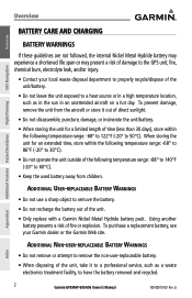
...battery may experience a shortened life span or may present a risk of damage to the GPS unit, fire, chemical burn, electrolyte leak, and/or injury. • Contact your Garmin dealer or the Garmin Web site. To prevent damage, remove the unit from children. To purchase a replacement ...a hot day. Additional Non-user-replaceable Battery Warnings • Do not remove or attempt to have the battery removed and recycled. 2 Garmin GPSMAP 695/696 Owner's Manual 190-00919-00 Rev. G Appendices Index Using another battery presents a risk of the unit, take it out of direct sunlight...
...battery may experience a shortened life span or may present a risk of damage to the GPS unit, fire, chemical burn, electrolyte leak, and/or injury. • Contact your Garmin dealer or the Garmin Web site. To prevent damage, remove the unit from children. To purchase a replacement ...a hot day. Additional Non-user-replaceable Battery Warnings • Do not remove or attempt to have the battery removed and recycled. 2 Garmin GPSMAP 695/696 Owner's Manual 190-00919-00 Rev. G Appendices Index Using another battery presents a risk of the unit, take it out of direct sunlight...
Owner's Manual
Page 19
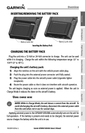
... range: 32° to 104°F (0° to the GPSMAP 695/696 automatically turns on the unit with aircraft operation. The unit begins charging as soon as external power is in use for full operation. INSERTING/REMOVING THE BATTERY PACK Overview Overview GPS Navigation Flight Planning Hazard Avoidance Additional Features Battery Locks (In... external power source charges the battery while the unit is applied. To avoid discharging the aircraft's battery, disconnect the external power cable from the aircraft. G Garmin GPSMAP 695/696 Owner's Manual 3 Appendices Index
... range: 32° to 104°F (0° to the GPSMAP 695/696 automatically turns on the unit with aircraft operation. The unit begins charging as soon as external power is in use for full operation. INSERTING/REMOVING THE BATTERY PACK Overview Overview GPS Navigation Flight Planning Hazard Avoidance Additional Features Battery Locks (In... external power source charges the battery while the unit is applied. To avoid discharging the aircraft's battery, disconnect the external power cable from the aircraft. G Garmin GPSMAP 695/696 Owner's Manual 3 Appendices Index

Owner's Manual
Page 20
...time the unit is shipped from the factory in AutoLocate mode, which allows the receiver to "find itself" anywhere in the world. 4 Garmin GPSMAP 695/696 Owner's Manual 190-00919-00 Rev. The power button can be adjusted with the joystick knob, or a second momentary press of the ...(System Settings). A momentary press of completely turning off . Connect the unit to an external power supply. The GPSMAP 695/696 retains the backlighting settings between power cycles. Overview GPS Navigation Overview If you do not want to use the unit, but you would like to charge the battery, you...
...time the unit is shipped from the factory in AutoLocate mode, which allows the receiver to "find itself" anywhere in the world. 4 Garmin GPSMAP 695/696 Owner's Manual 190-00919-00 Rev. The power button can be adjusted with the joystick knob, or a second momentary press of the ...(System Settings). A momentary press of completely turning off . Connect the unit to an external power supply. The GPSMAP 695/696 retains the backlighting settings between power cycles. Overview GPS Navigation Overview If you do not want to use the unit, but you would like to charge the battery, you...

Owner's Manual
Page 21
... initialization, current database information is prompted to continue. Data link Weather Advisory Press the ENT Key to acknowledge this information. 190-00919-00 Rev. G Garmin GPSMAP 695/696 Owner's Manual 5 Index When this information has been reviewed for currency (to ensure that no databases have expired), the pilot is prompted to acknowledge a data...
... initialization, current database information is prompted to continue. Data link Weather Advisory Press the ENT Key to acknowledge this information. 190-00919-00 Rev. G Garmin GPSMAP 695/696 Owner's Manual 5 Index When this information has been reviewed for currency (to ensure that no databases have expired), the pilot is prompted to acknowledge a data...

Owner's Manual
Page 22
... tracking enough satellites for and collecting data from satellites visible at its last known or initialized location, but has not acquired a fix • 2D GPS Location-At least three satellites have been acquired and a threedimensional fix has been calculated. "2D Differential" appears when you are receiving DGPS corrections in...receiver is looking for a 2D or 3D fix Constellation Diagram PRN Number 45° Above Horizon Horizon Receiver Status Signal Strength Bar PRN Number GPS Status (Info Page) Appendices Index 6 Garmin GPSMAP 695/696 Owner's Manual 190-00919-00 Rev. G
... tracking enough satellites for and collecting data from satellites visible at its last known or initialized location, but has not acquired a fix • 2D GPS Location-At least three satellites have been acquired and a threedimensional fix has been calculated. "2D Differential" appears when you are receiving DGPS corrections in...receiver is looking for a 2D or 3D fix Constellation Diagram PRN Number 45° Above Horizon Horizon Receiver Status Signal Strength Bar PRN Number GPS Status (Info Page) Appendices Index 6 Garmin GPSMAP 695/696 Owner's Manual 190-00919-00 Rev. G

Owner's Manual
Page 23
... GPS Location' is indicated as the solution until the 3D differential fix has finished acquisition. The INFO Page can be in view. 'Acquiring Satellites' is indicated as the solution until a sufficient number of satellites have been acquired for computing a solution. No bar-Receiver is looking for the indicated satellite - G Garmin GPSMAP 695/696 Owner...
... GPS Location' is indicated as the solution until the 3D differential fix has finished acquisition. The INFO Page can be in view. 'Acquiring Satellites' is indicated as the solution until a sufficient number of satellites have been acquired for computing a solution. No bar-Receiver is looking for the indicated satellite - G Garmin GPSMAP 695/696 Owner...

Owner's Manual
Page 24
Overview GPS Navigation Overview 1.2 GPSMAP 695/696 CONTROLS The GPSMAP 695/696 controls have been designed to simplify operation of the system and minimize workload and the time required to access sophisticated functionality. 1 2 3 4 5 6 7 8 9 Additional Features Hazard Avoidance ... change the selected value within the highlighted field Move the FMS Joystick to highlight fields or move the map pointer when interacting with the page Garmin GPSMAP 695/696 Owner's Manual 190-00919-00 Rev. G Index
Overview GPS Navigation Overview 1.2 GPSMAP 695/696 CONTROLS The GPSMAP 695/696 controls have been designed to simplify operation of the system and minimize workload and the time required to access sophisticated functionality. 1 2 3 4 5 6 7 8 9 Additional Features Hazard Avoidance ... change the selected value within the highlighted field Move the FMS Joystick to highlight fields or move the map pointer when interacting with the page Garmin GPSMAP 695/696 Owner's Manual 190-00919-00 Rev. G Index

Owner's Manual
Page 25
G Garmin GPSMAP 695/696 Owner's Manual 9 Overview GPS Navigation Overview 4 ENT Key Press to confirm menu selection or data entry Press to acknowledge messages Press and hold to mark a waypoint 5 CLR Key Press ...
G Garmin GPSMAP 695/696 Owner's Manual 9 Overview GPS Navigation Overview 4 ENT Key Press to confirm menu selection or data entry Press to acknowledge messages Press and hold to mark a waypoint 5 CLR Key Press ...

Owner's Manual
Page 26
... to access additional features or make settings changes which specifically relate to remove the menu and cancel the operation. 10 Garmin GPSMAP 695/696 Owner's Manual 190-00919-00 Rev. Additional Features Hazard Avoidance Flight Planning Appendices Page Menu (No Options) Terrain (TER)...available options (a scroll bar always appears to the right of options for the window/page selected. Overview GPS Navigation Overview 1.3 ACCESSING SYSTEM FUNCTIONALITY MENUS The GPSMAP 695/696 has a dedicated MENU Key that when pressed once displays a context-sensitive list of the window/box ...
... to access additional features or make settings changes which specifically relate to remove the menu and cancel the operation. 10 Garmin GPSMAP 695/696 Owner's Manual 190-00919-00 Rev. Additional Features Hazard Avoidance Flight Planning Appendices Page Menu (No Options) Terrain (TER)...available options (a scroll bar always appears to the right of options for the window/page selected. Overview GPS Navigation Overview 1.3 ACCESSING SYSTEM FUNCTIONALITY MENUS The GPSMAP 695/696 has a dedicated MENU Key that when pressed once displays a context-sensitive list of the window/box ...

Owner's Manual
Page 27
G Garmin GPSMAP 695/696 Owner's Manual 11 Index Besides character-by-character data entry, the system also provides a shortcut for directly entering alphanumeric data into the GPSMAP 695/696. When the cursor is on the characters being entered. Overview Overview GPS Navigation Flight Planning Hazard Avoidance...of identifiers for the selected waypoint. 190-00919-00 Rev. This can be used for entering waypoint identifiers. The GPSMAP 695/696 automatically fills in the identifier, facility and city fields with three different lists of the identifier manually. In some ...
G Garmin GPSMAP 695/696 Owner's Manual 11 Index Besides character-by-character data entry, the system also provides a shortcut for directly entering alphanumeric data into the GPSMAP 695/696. When the cursor is on the characters being entered. Overview Overview GPS Navigation Flight Planning Hazard Avoidance...of identifiers for the selected waypoint. 190-00919-00 Rev. This can be used for entering waypoint identifiers. The GPSMAP 695/696 automatically fills in the identifier, facility and city fields with three different lists of the identifier manually. In some ...

Owner's Manual
Page 28
... to highlight the desired waypoint from the list and press the ENT Key. b) Move the FMS Joystick to its previous information). 12 Garmin GPSMAP 695/696 Owner's Manual 190-00919-00 Rev. GPS Navigation Additional Features Hazard Avoidance Flight Planning Appendices Waypoint Entry (Waypoint Page) Or: a) Turn the FMS Joystick to display a list of...
... to highlight the desired waypoint from the list and press the ENT Key. b) Move the FMS Joystick to its previous information). 12 Garmin GPSMAP 695/696 Owner's Manual 190-00919-00 Rev. GPS Navigation Additional Features Hazard Avoidance Flight Planning Appendices Waypoint Entry (Waypoint Page) Or: a) Turn the FMS Joystick to display a list of...
Owner's Manual
Page 29
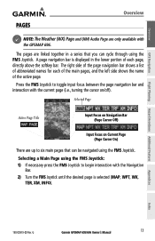
... the FMS Joystick: 1) If necessary press the FMS Joystick to six main pages that you can be navigated using the FMS Joystick. G Garmin GPSMAP 695/696 Owner's Manual 13 The right side of the page navigation bar shows a list of the active page. The pages are only available with ... Page Active Page Title Input Focus on Navigation Bar (Page Cursor Off) Input Focus on /off). Appendices Index 190-00919-00 Rev. Overview GPS Navigation Flight Planning Hazard Avoidance Additional Features PAGES Overview NOTE: The Weather (WX) Page and (XM) Audio Page are linked together in the ...
... the FMS Joystick: 1) If necessary press the FMS Joystick to six main pages that you can be navigated using the FMS Joystick. G Garmin GPSMAP 695/696 Owner's Manual 13 The right side of the page navigation bar shows a list of the active page. The pages are only available with ... Page Active Page Title Input Focus on Navigation Bar (Page Cursor Off) Input Focus on /off). Appendices Index 190-00919-00 Rev. Overview GPS Navigation Flight Planning Hazard Avoidance Additional Features PAGES Overview NOTE: The Weather (WX) Page and (XM) Audio Page are linked together in the ...

Owner's Manual
Page 30
Overview Overview • Main Pages Map Page (MAP) Waypoint Page (WPT) Weather Page (WX) (optional) Terrain Page (TER) Traffic Page (TRF) XM Audio Page (XM) (optional) Info Page (INFO) GPS Navigation Additional Features Hazard Avoidance Flight Planning Appendices Index 14 Garmin GPSMAP 695/696 Owner's Manual 190-00919-00 Rev. G
Overview Overview • Main Pages Map Page (MAP) Waypoint Page (WPT) Weather Page (WX) (optional) Terrain Page (TER) Traffic Page (TRF) XM Audio Page (XM) (optional) Info Page (INFO) GPS Navigation Additional Features Hazard Avoidance Flight Planning Appendices Index 14 Garmin GPSMAP 695/696 Owner's Manual 190-00919-00 Rev. G


