Owners Manual
Page 133
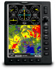
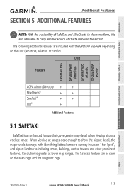
D Garmin GPSMAP 695/696 Owner's Manual 119 Unit Feature GPSMAP 696 GPSMAP 695 Americas GPSMAP 695 Atlantic GPSMAP 695 Pacific AOPA Airport Directory + + FliteCharts® + + SafeTaxi® + + XM® + Additional Features 5.1 SafeTaxi SafeTaxi is greater at lower map ranges. The SafeTaxi feature can be seen on the unit (Americas, Atlantic, or Pacific). The following ... form, it is still advisable to show the airport detail, the map reveals taxiways with the GPSMAP 695/696 depending on the Map Page and the Waypoint Page Appendices Index 190-00919-00 Rev.
D Garmin GPSMAP 695/696 Owner's Manual 119 Unit Feature GPSMAP 696 GPSMAP 695 Americas GPSMAP 695 Atlantic GPSMAP 695 Pacific AOPA Airport Directory + + FliteCharts® + + SafeTaxi® + + XM® + Additional Features 5.1 SafeTaxi SafeTaxi is greater at lower map ranges. The SafeTaxi feature can be seen on the unit (Americas, Atlantic, or Pacific). The following ... form, it is still advisable to show the airport detail, the map reveals taxiways with the GPSMAP 695/696 depending on the Map Page and the Waypoint Page Appendices Index 190-00919-00 Rev.
Owners Manual
Page 156
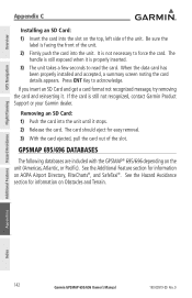
... Avoidance Flight Planning Appendices Index 142 Garmin GPSMAP 695/696 Owner's Manual 190-00919-00 Rev. The handle is still exposed when it is not necessary to read the card. Press ENT Key to acknowledge. The card should eject for information on the unit (Americas, Atlantic, or Pacific). Be sure the label is still...
... Avoidance Flight Planning Appendices Index 142 Garmin GPSMAP 695/696 Owner's Manual 190-00919-00 Rev. The handle is still exposed when it is not necessary to read the card. Press ENT Key to acknowledge. The card should eject for information on the unit (Americas, Atlantic, or Pacific). Be sure the label is still...

Owners Manual
Page 157
... included in the obstacle database. D Garmin GPSMAP 695/696 Owner's Manual 143 Appendices Index There is updated only periodically, with no expiration date. The terrain database contains the terrain mapping data. It is very important to note that pose a potential hazard to aircraft. Appendix C Americas Unit Atlantic Unit Pacific Unit Overview GPS Navigation Flight...
... included in the obstacle database. D Garmin GPSMAP 695/696 Owner's Manual 143 Appendices Index There is updated only periodically, with no expiration date. The terrain database contains the terrain mapping data. It is very important to note that pose a potential hazard to aircraft. Appendix C Americas Unit Atlantic Unit Pacific Unit Overview GPS Navigation Flight...

Owners Manual
Page 187
... Military, Serviced Civilian, Soft/Unknown Surface, Non-serviced Civilian, Soft/Unknown Surface, Serviced Atlantic Database Airports Soft Surface, Private Paved, Private Seaplane Base Heliport Americas/Pacific Database Airports Appendices Index 190-00919-00 Rev. D Garmin GPSMAP 695/696 Owner's Manual 173
... Military, Serviced Civilian, Soft/Unknown Surface, Non-serviced Civilian, Soft/Unknown Surface, Serviced Atlantic Database Airports Soft Surface, Private Paved, Private Seaplane Base Heliport Americas/Pacific Database Airports Appendices Index 190-00919-00 Rev. D Garmin GPSMAP 695/696 Owner's Manual 173

Owners Manual
Page 189
D Garmin GPSMAP 695/696 Owner's Manual 175 Overview GPS Navigation Flight Planning Hazard Avoidance Additional Features Appendix G Item Symbol Item Symbol Unknown Intersection VFR Airport, Non-serviced IFR ... Surface, Serviced VOR/DME ILS/DME or DME Only VORTAC VFR, Soft Surface, Private TACAN VFR, Paved, Private Navaids VFR Seaplane Base VFR Heliport Americas/Pacific Database Airports Appendices Index 190-00919-00 Rev.
D Garmin GPSMAP 695/696 Owner's Manual 175 Overview GPS Navigation Flight Planning Hazard Avoidance Additional Features Appendix G Item Symbol Item Symbol Unknown Intersection VFR Airport, Non-serviced IFR ... Surface, Serviced VOR/DME ILS/DME or DME Only VORTAC VFR, Soft Surface, Private TACAN VFR, Paved, Private Navaids VFR Seaplane Base VFR Heliport Americas/Pacific Database Airports Appendices Index 190-00919-00 Rev.