Owners Manual
Page 6
... field of obstacle and terrain avoidance information. The Terrain Proximity feature is not certified for primary navigation. Garmin is obtained from the altitude displayed by GPSMAP 695/696 GPS receiver is NOT intended to be used for appropriate minimum clearance altitudes. Always refer to be used...database do so entirely at their own risk. Databases used as the sole source of view or interfere with operating controls. Garmin GPSMAP 695/696 Owner's Manual 190-00919-00 Rev. WARNING: Navigation and terrain separation must be predicated upon as an aid for terrain ...
... field of obstacle and terrain avoidance information. The Terrain Proximity feature is not certified for primary navigation. Garmin is obtained from the altitude displayed by GPSMAP 695/696 GPS receiver is NOT intended to be used for appropriate minimum clearance altitudes. Always refer to be used...database do so entirely at their own risk. Databases used as the sole source of view or interfere with operating controls. Garmin GPSMAP 695/696 Owner's Manual 190-00919-00 Rev. WARNING: Navigation and terrain separation must be predicated upon as an aid for terrain ...
Owners Manual
Page 7
... providing monitoring and/or self-test capability for the aircraft. Portions of the GPSMAP 695/696 User's Manual documentation and the Pilot's Operating Handbook for all aspects of the Garmin GPSMAP 695/696 utilize GPS as a precision electronic NAVigation AID (NAVAID). Therefore, as an ...of functional integrity. It is approved only for its accuracy and maintenance. D Garmin GPSMAP 695/696 Owner's Manual Warning: NEXRAD weather data is subject to actual use. WARNING: The Garmin GPSMAP 695/696 has a very high degree of cross-checking with all available navigation sources, ...
... providing monitoring and/or self-test capability for the aircraft. Portions of the GPSMAP 695/696 User's Manual documentation and the Pilot's Operating Handbook for all aspects of the Garmin GPSMAP 695/696 utilize GPS as a precision electronic NAVigation AID (NAVAID). Therefore, as an ...of functional integrity. It is approved only for its accuracy and maintenance. D Garmin GPSMAP 695/696 Owner's Manual Warning: NEXRAD weather data is subject to actual use. WARNING: The Garmin GPSMAP 695/696 has a very high degree of cross-checking with all available navigation sources, ...

Owners Manual
Page 8
... FAA Advisory Circular, Subject: Thunderstorms, and the Aeronautical Information Manual (AIM) recommend avoiding "by an authorized Garmin service center. CAUTION: The Garmin GPSMAP 695/696 does not contain any thunderstorm identified as safe for anti-reflective coatings. Unauthorized repairs or modifications could void both... at least 20 miles any user-serviceable parts. This notice is specified as severe or giving an intense radar echo." Garmin GPSMAP 695/696 Owner's Manual 190-00919-00 Rev. Operation is very sensitive to skin oils, waxes, and abrasive cleaners. NOTE:...
... FAA Advisory Circular, Subject: Thunderstorms, and the Aeronautical Information Manual (AIM) recommend avoiding "by an authorized Garmin service center. CAUTION: The Garmin GPSMAP 695/696 does not contain any thunderstorm identified as safe for anti-reflective coatings. Unauthorized repairs or modifications could void both... at least 20 miles any user-serviceable parts. This notice is specified as severe or giving an intense radar echo." Garmin GPSMAP 695/696 Owner's Manual 190-00919-00 Rev. Operation is very sensitive to skin oils, waxes, and abrasive cleaners. NOTE:...
Owners Manual
Page 9
Warnings, Cautions & Notes NOTE: Use of normal business hours. NOTE: XM Weather is only available when the optional GXM 40 antenna is provided by the FAA and may not be updated outside of polarized eyewear may cause the display to appear dim or blank. D Garmin GPSMAP 695/696 Owner's Manual NOTE: Temporary Flight Restriction (TFR) data is installed. 190-00919-00 Rev. Confirm data currency through alternate sources and contact your local FSS for interpretation of TFR data.
Warnings, Cautions & Notes NOTE: Use of normal business hours. NOTE: XM Weather is only available when the optional GXM 40 antenna is provided by the FAA and may not be updated outside of polarized eyewear may cause the display to appear dim or blank. D Garmin GPSMAP 695/696 Owner's Manual NOTE: Temporary Flight Restriction (TFR) data is installed. 190-00919-00 Rev. Confirm data currency through alternate sources and contact your local FSS for interpretation of TFR data.

Owners Manual
Page 10
D Warnings, Cautions & Notes Blank Page Garmin GPSMAP 695/696 Owner's Manual 190-00919-00 Rev.
D Warnings, Cautions & Notes Blank Page Garmin GPSMAP 695/696 Owner's Manual 190-00919-00 Rev.

Owners Manual
Page 11
D Garmin GPSMAP 695/696 Owner's Manual i Table of Contents Section 1 Overview 1 1.1 Unit Overview...1 Battery Care and Charging...1 Turning the Unit On/Off...4 GPS Receiver Status...5 1.2 GPSMAP 695/696 Controls 7 Menus...12 Data Entry...13 Pages...15 1.3 System Settings...20 Display...22 Sound...23 Units...23 Date & Time...24 Position...25 Interface...25 Alarms......
D Garmin GPSMAP 695/696 Owner's Manual i Table of Contents Section 1 Overview 1 1.1 Unit Overview...1 Battery Care and Charging...1 Turning the Unit On/Off...4 GPS Receiver Status...5 1.2 GPSMAP 695/696 Controls 7 Menus...12 Data Entry...13 Pages...15 1.3 System Settings...20 Display...22 Sound...23 Units...23 Date & Time...24 Position...25 Interface...25 Alarms......

Owners Manual
Page 12
... Flight Plan...86 3.5 Approaches...87 Selecting an Approach...88 Activating Vectors-to-Final 90 3.6 Trip Planning...92 Section 4 Hazard Avoidance 93 4.1 XM Weather (GPSMAP 696 93 Activating Services...93 XM Satellite Weather Products 94 Using XM Satellite Weather Products 103 4.2 Terrain...107 Terrain Information...108 Obstacle Information...108 Terrain and... Terrain Alerts...112 4.3 Traffic Information Service (TIS 114 TIS Symbology...114 TIS Alerts...114 Traffic Ground Track ...115 Displaying Traffic Data...116 ii Garmin GPSMAP 695/696 Owner's Manual 190-00919-00 Rev.
... Flight Plan...86 3.5 Approaches...87 Selecting an Approach...88 Activating Vectors-to-Final 90 3.6 Trip Planning...92 Section 4 Hazard Avoidance 93 4.1 XM Weather (GPSMAP 696 93 Activating Services...93 XM Satellite Weather Products 94 Using XM Satellite Weather Products 103 4.2 Terrain...107 Terrain Information...108 Obstacle Information...108 Terrain and... Terrain Alerts...112 4.3 Traffic Information Service (TIS 114 TIS Symbology...114 TIS Alerts...114 Traffic Ground Track ...115 Displaying Traffic Data...116 ii Garmin GPSMAP 695/696 Owner's Manual 190-00919-00 Rev.

Owners Manual
Page 13
...SD Card Use and Databases 141 SD Card Use...141 GPSMAP 695/696 Databases 142 Installation & Interfacing Information 147 Connecting the Power/Data Cable 147 Connecting to a Garmin VHF Comm Radio 148 Connecting to a Computer 149 ...Information about USB Drivers 149 Using xImage for Customized Waypoint Symbols 150 Connecting the GXM 40 Antenna (GPSMAP 696 150 Connecting to a GTX 330 Mode S Transponder 151 Interfacing...151 Using an external GPS Antenna (Optional 154 General TIS Information 155 TIS vs. D Garmin GPSMAP 695/696...
...SD Card Use and Databases 141 SD Card Use...141 GPSMAP 695/696 Databases 142 Installation & Interfacing Information 147 Connecting the Power/Data Cable 147 Connecting to a Garmin VHF Comm Radio 148 Connecting to a Computer 149 ...Information about USB Drivers 149 Using xImage for Customized Waypoint Symbols 150 Connecting the GXM 40 Antenna (GPSMAP 696 150 Connecting to a GTX 330 Mode S Transponder 151 Interfacing...151 Using an external GPS Antenna (Optional 154 General TIS Information 155 TIS vs. D Garmin GPSMAP 695/696...

Owners Manual
Page 14
Table of Contents EPE Circle...170 Proximity Waypoints...171 Display Symbols...173 VFR Symbols...173 IFR Symbols...174 Airspace Symbols...176 Map Datum and Location Formats 179 Map Datums...179 Location Formats...179 Glossary...181 License Agreement and Warranty 187 Contact Garmin...187 Software License Agreement 187 Limited Warranty...187 AOPA Airport Directory Notice 188 Weather Data Warranty...188 XM Satellite Radio Service Agreement 190 FCC Compliance...190 Industry Canada Compliance 190 iv Garmin GPSMAP 695/696 Owner's Manual 190-00919-00 Rev. D
Table of Contents EPE Circle...170 Proximity Waypoints...171 Display Symbols...173 VFR Symbols...173 IFR Symbols...174 Airspace Symbols...176 Map Datum and Location Formats 179 Map Datums...179 Location Formats...179 Glossary...181 License Agreement and Warranty 187 Contact Garmin...187 Software License Agreement 187 Limited Warranty...187 AOPA Airport Directory Notice 188 Weather Data Warranty...188 XM Satellite Radio Service Agreement 190 FCC Compliance...190 Industry Canada Compliance 190 iv Garmin GPSMAP 695/696 Owner's Manual 190-00919-00 Rev. D

Owners Manual
Page 15
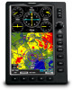
D Garmin GPSMAP 695/696 Owner's Manual 1 Index Overview Section 1 Overview Overview 1.1 Unit Overview The GPSMAP 695/696 presents GPS-derived analog flight instrumentation, position, navigation, and hazard avoidance information to the pilot using a 7" Wide VGA (800x480) color display. 7" WVGA (800x480) Color Display ...
D Garmin GPSMAP 695/696 Owner's Manual 1 Index Overview Section 1 Overview Overview 1.1 Unit Overview The GPSMAP 695/696 presents GPS-derived analog flight instrumentation, position, navigation, and hazard avoidance information to the pilot using a 7" Wide VGA (800x480) color display. 7" WVGA (800x480) Color Display ...

Owners Manual
Page 16
... remove the battery. • Do not recharge the battery out of the unit. • Only replace with a Garmin Nickel Metal Hydride battery pack. Using another battery presents a risk of fire or explosion. Appendices Index 2 Garmin GPSMAP 695/696 Owner's Manual 190-00919-00 Rev. Additional User-replaceable Battery Warnings • Do not use a sharp object...
... remove the battery. • Do not recharge the battery out of the unit. • Only replace with a Garmin Nickel Metal Hydride battery pack. Using another battery presents a risk of fire or explosion. Appendices Index 2 Garmin GPSMAP 695/696 Owner's Manual 190-00919-00 Rev. Additional User-replaceable Battery Warnings • Do not use a sharp object...

Owners Manual
Page 17
... can be charged, the external power source charges the battery while the unit is present and needs to 40°C). Connect the unit to the GPSMAP 695/696 automatically turns on the unit for full operation. Using charge mode Applying external power to an external power supply. Charging the unit's battery pack: 1) Align... goes into Charge Mode. Charge the unit within the following temperature range: 32° to 104°F (0° to be used while it is applied. D Garmin GPSMAP 695/696 Owner's Manual 3 Appendices Index
... can be charged, the external power source charges the battery while the unit is present and needs to 40°C). Connect the unit to the GPSMAP 695/696 automatically turns on the unit for full operation. Using charge mode Applying external power to an external power supply. Charging the unit's battery pack: 1) Align... goes into Charge Mode. Charge the unit within the following temperature range: 32° to 104°F (0° to be used while it is applied. D Garmin GPSMAP 695/696 Owner's Manual 3 Appendices Index

Owners Manual
Page 18
... displayed. Pressing the ENT Key acknowledges this information has been reviewed for several days. Additional Features Hazard Avoidance Flight Planning Appendices Index Database Initialization 4 Garmin GPSMAP 695/696 Owner's Manual 190-00919-00 Rev. D To avoid discharging the aircraft's battery, disconnect the external power cable from the unit when not in Charge Mode, ...
... displayed. Pressing the ENT Key acknowledges this information has been reviewed for several days. Additional Features Hazard Avoidance Flight Planning Appendices Index Database Initialization 4 Garmin GPSMAP 695/696 Owner's Manual 190-00919-00 Rev. D To avoid discharging the aircraft's battery, disconnect the external power cable from the unit when not in Charge Mode, ...

Owners Manual
Page 19
... are receiving DGPS corrections in 2D mode • 3D GPS Location-At least four satellites have been acquired and a twodimensional location fix has been calculated. D Garmin GPSMAP 695/696 Owner's Manual 5 Overview GPS Navigation Flight Planning Hazard Avoidance Additional Features Overview GPS Receiver Status The receiver status field on the INFO Page displays one...
... are receiving DGPS corrections in 2D mode • 3D GPS Location-At least four satellites have been acquired and a twodimensional location fix has been calculated. D Garmin GPSMAP 695/696 Owner's Manual 5 Overview GPS Navigation Flight Planning Hazard Avoidance Additional Features Overview GPS Receiver Status The receiver status field on the INFO Page displays one...
Owners Manual
Page 20
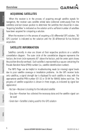
... by signal bar appearance: - Each satellite is indicated as the solution until a sufficient number of satellites have been acquired for the GPS solution Appendices Index 6 Garmin GPSMAP 695/696 Owner's Manual 190-00919-00 Rev. D The progress of satellite acquisition is displayed for each satellite in view, with the appropriate satellite PRN number (01...
... by signal bar appearance: - Each satellite is indicated as the solution until a sufficient number of satellites have been acquired for the GPS solution Appendices Index 6 Garmin GPSMAP 695/696 Owner's Manual 190-00919-00 Rev. D The progress of satellite acquisition is displayed for each satellite in view, with the appropriate satellite PRN number (01...

Owners Manual
Page 21
... With the unit on, press to adjust the backlight and volume Press to highlight fields or move the map pointer when interacting with the page Garmin GPSMAP 695/696 Owner's Manual 7 Index Overview GPS Navigation Overview 1.2 GPSMAP 695/696 Controls The GPSMAP 695/696 controls have been designed to simplify operation of the map 3 FMS Joystick 190-00919-00 Rev.
... With the unit on, press to adjust the backlight and volume Press to highlight fields or move the map pointer when interacting with the page Garmin GPSMAP 695/696 Owner's Manual 7 Index Overview GPS Navigation Overview 1.2 GPSMAP 695/696 Controls The GPSMAP 695/696 controls have been designed to simplify operation of the map 3 FMS Joystick 190-00919-00 Rev.

Owners Manual
Page 22
... on black background. The softkeys shown depend on the unit Selection Keys Softkey Function The softkeys are located along the bottom of inactivity. Appendices Index 8 Garmin GPSMAP 695/696 Owner's Manual 190-00919-00 Rev. D Overview GPS Navigation Additional Features Hazard Avoidance Flight Planning Overview 4 ENT Key Press to confirm menu selection or data...
... on black background. The softkeys shown depend on the unit Selection Keys Softkey Function The softkeys are located along the bottom of inactivity. Appendices Index 8 Garmin GPSMAP 695/696 Owner's Manual 190-00919-00 Rev. D Overview GPS Navigation Additional Features Hazard Avoidance Flight Planning Overview 4 ENT Key Press to confirm menu selection or data...

Owners Manual
Page 23
D Garmin GPSMAP 695/696 Owner's Manual 9 Overview GPS Navigation Flight Planning Hazard Avoidance Additional Features Softkey On Bezel Mounted Softkeys (Press) Softkeys (WPT Page) MAP Page Softkeys MAP TERRAIN ...
D Garmin GPSMAP 695/696 Owner's Manual 9 Overview GPS Navigation Flight Planning Hazard Avoidance Additional Features Softkey On Bezel Mounted Softkeys (Press) Softkeys (WPT Page) MAP Page Softkeys MAP TERRAIN ...

Owners Manual
Page 24
... information Displays optional FliteCharts Displays AOPA information Displays METAR and TAF text Weather Page Softkeys (GPSMAP 696 ONLY) PAN MAP ANIMATE INFO LEGEND PAN MAP ANIMATE INFO LEGEND Activates the map pointer for panning the map Animates NEXRAD weather Displays XM Information Displays weather legends 10 Garmin GPSMAP 695/696 Owner's Manual 190-00919-00 Rev.
... information Displays optional FliteCharts Displays AOPA information Displays METAR and TAF text Weather Page Softkeys (GPSMAP 696 ONLY) PAN MAP ANIMATE INFO LEGEND PAN MAP ANIMATE INFO LEGEND Activates the map pointer for panning the map Animates NEXRAD weather Displays XM Information Displays weather legends 10 Garmin GPSMAP 695/696 Owner's Manual 190-00919-00 Rev.

Owners Manual
Page 25
...-level softkeys Appendices Index 190-00919-00 Rev. Press and hold to toggle Mute on /off . D Garmin GPSMAP 695/696 Owner's Manual 11 Overview GPS Navigation Flight Planning Hazard Avoidance Additional Features Overview XM Audio Page Softkeys (GPSMAP 696 Only) INFO CATEGORY CHANNEL FAVORITE VOLUME INFO CATEGORY CHANNEL FAVORITE • VOLUME Displays XM Information Highlights the...
...-level softkeys Appendices Index 190-00919-00 Rev. Press and hold to toggle Mute on /off . D Garmin GPSMAP 695/696 Owner's Manual 11 Overview GPS Navigation Flight Planning Hazard Avoidance Additional Features Overview XM Audio Page Softkeys (GPSMAP 696 Only) INFO CATEGORY CHANNEL FAVORITE VOLUME INFO CATEGORY CHANNEL FAVORITE • VOLUME Displays XM Information Highlights the...