
Owners Manual
Page 2
...the written consent of their respective owners. Go to make changes in the U.S. Garmin®, the Garmin logo, ANT+®, AutoLocate®, City Navigator®, GPSMAP®, and VIRB® are those of Garmin. and any person or organization of Apple Inc., registered in the content of... Garmin. © 2013 Garmin Ltd. or its products and to www.garmin.com for a list of Garmin Ltd. These trademarks may ...
...the written consent of their respective owners. Go to make changes in the U.S. Garmin®, the Garmin logo, ANT+®, AutoLocate®, City Navigator®, GPSMAP®, and VIRB® are those of Garmin. and any person or organization of Apple Inc., registered in the content of... Garmin. © 2013 Garmin Ltd. or its products and to www.garmin.com for a list of Garmin Ltd. These trademarks may ...
Owners Manual
Page 3
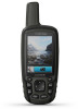
...Introduction 1 Device Overviews 1 GPSMAP Device Overview (No Camera 1 GPSMAP Device Overview (Camera 1 ... 5 Taking a Photo 5 Viewing Photos 5 Using the Flashlight 6 Geocaches 6 Downloading Geocaches Using a Computer 6 Navigating to a Geocache 6 chirp 6 Sending and Receiving Data Wirelessly 6 Setting a Proximity Alarm 6 Selecting a Profile ...6 Area Calculation 6 Calculating the Size of an Area 6 Satellite Page 6 GPS Satellite Settings 6 Garmin Adventures 7 Sending Files to BaseCamp 7 Creating an Adventure 7 Starting an Adventure 7 VIRB® Remote 7 Waypoint...
...Introduction 1 Device Overviews 1 GPSMAP Device Overview (No Camera 1 GPSMAP Device Overview (Camera 1 ... 5 Taking a Photo 5 Viewing Photos 5 Using the Flashlight 6 Geocaches 6 Downloading Geocaches Using a Computer 6 Navigating to a Geocache 6 chirp 6 Sending and Receiving Data Wirelessly 6 Setting a Proximity Alarm 6 Selecting a Profile ...6 Area Calculation 6 Calculating the Size of an Area 6 Satellite Page 6 GPS Satellite Settings 6 Garmin Adventures 7 Sending Files to BaseCamp 7 Creating an Adventure 7 Starting an Adventure 7 VIRB® Remote 7 Waypoint...
Owners Manual
Page 7
... > Map. Automotive Mode shows an 3D automotive view with the direction of travel at an object. 3 Select Lock Direction > Set Course. 4 Navigate using the compass. Data Fields: Customizes the data fields and dashboards of the compass. You should calibrate the compass after moving . To enable the.... 1 From the compass, select MENU. 2 Select Calibrate Compass > Start. 3 Follow the on the page. The device has a 3-axis electronic compass (GPSMAP 64s/sc/st/sx/csx devices only). You can customize the compass settings. NOTE: Your customized settings are not lost when you are no major...
... > Map. Automotive Mode shows an 3D automotive view with the direction of travel at an object. 3 Select Lock Direction > Set Course. 4 Navigate using the compass. Data Fields: Customizes the data fields and dashboards of the compass. You should calibrate the compass after moving . To enable the.... 1 From the compass, select MENU. 2 Select Calibrate Compass > Start. 3 Follow the on the page. The device has a 3-axis electronic compass (GPSMAP 64s/sc/st/sx/csx devices only). You can customize the compass settings. NOTE: Your customized settings are not lost when you are no major...
Owners Manual
Page 8
...elevation changes over a period of measure. 6 Enter the distance, and select Done. 7 Select Save. NOTE: The barometric altimeter is available only with GPSMAP 64s/sc/st/sx/csx devices. Change Data Fields: Customizes the elevation plot data fields. Calibrate Altimeter: See (Calibrating the Barometric Altimeter, page 4)....new location by transferring the file to the GPX folder (Transferring Files to your current location as name, elevation, and depth. Navigating to save your final destination. By default, the elevation plot displays the elevation over a distance.
...elevation changes over a period of measure. 6 Enter the distance, and select Done. 7 Select Save. NOTE: The barometric altimeter is available only with GPSMAP 64s/sc/st/sx/csx devices. Change Data Fields: Customizes the elevation plot data fields. Calibrate Altimeter: See (Calibrating the Barometric Altimeter, page 4)....new location by transferring the file to the GPX folder (Transferring Files to your current location as name, elevation, and depth. Navigating to save your final destination. By default, the elevation plot displays the elevation over a distance.
Owners Manual
Page 10
... you can change the setup of strobes per second. When you can log your device. Navigating to a Geocache 1 Select Geocaches. 2 Select a geocache. 3 Select Go. You can verify some geocaches at www.garmin.com. Navigating to a Photo 1 Select Photo Viewer. 2 Select a photo. 3 Select MENU > View...and Settings You can send and receive data when paired with another device. Selecting a Profile When you change activities, you enter an area with GPSMAP 64s/sc/st/sx/csx devices. Viewing the Location of a compatible device. Deleting a Photo 1 Select Photo Viewer. 2 Select a photo. ...
... you can change the setup of strobes per second. When you can log your device. Navigating to a Geocache 1 Select Geocaches. 2 Select a geocache. 3 Select Go. You can verify some geocaches at www.garmin.com. Navigating to a Photo 1 Select Photo Viewer. 2 Select a photo. 3 Select MENU > View...and Settings You can send and receive data when paired with another device. Selecting a Profile When you change activities, you enter an area with GPSMAP 64s/sc/st/sx/csx devices. Viewing the Location of a compatible device. Deleting a Photo 1 Select Photo Viewer. 2 Select a photo. ...


