Owner's Manual
Page 7
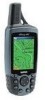
.... MAP DATA INFORMATION: One of the goals of Garmin is to provide customers with California's Proposition 65. This Notice is solely responsible for its components contain chemicals known to the State of all data sources contain inaccurate or incomplete data to the consumer. GPSmap 60C Introduction Warnings and Precautions v WARNING: The Global Positioning System (GPS...
.... MAP DATA INFORMATION: One of the goals of Garmin is to provide customers with California's Proposition 65. This Notice is solely responsible for its components contain chemicals known to the State of all data sources contain inaccurate or incomplete data to the consumer. GPSmap 60C Introduction Warnings and Precautions v WARNING: The Global Positioning System (GPS...
Owner's Manual
Page 9
... Started 1-7 Battery Installation and Start Up 1 Key Functions 2 Unit Features 3 Initialization 4 The Satellite Page 4 Navigating with the GPSmap 60C 5 The Main Page Sequence 6 The Main Page Features 7 Table of Contents Section 3: GPS Navigation 8-54 The Map Page 8 The Compass Page 14 The Trip Computer Page 16 Using Waypoints 17 Using Find 21 The Main...
... Started 1-7 Battery Installation and Start Up 1 Key Functions 2 Unit Features 3 Initialization 4 The Satellite Page 4 Navigating with the GPSmap 60C 5 The Main Page Sequence 6 The Main Page Features 7 Table of Contents Section 3: GPS Navigation 8-54 The Map Page 8 The Compass Page 14 The Trip Computer Page 16 Using Waypoints 17 Using Find 21 The Main...

Owner's Manual
Page 10
GPSmap 60C Introduction Table of Contents Section 4: GPS Features 57-65 Calendar 57 Alarm Clock 58 Calculator 58 Stopwatch 59 Sun and Moon Tables 60 Hunt and Fish Tables 61 GPS Enhanced Games 62 Non-Enhanced Game 65 Section 5: Appendix 66-83 Accessories 66 Specifications 68 Data Field Definitions 70 Connecting the GPSmap 60C to a Computer 74 Downloading MapSource Map Data 75 UTC Offset Chart 76 Map Datums and Position Formats 77 Loran TD Setup 78 WAAS and DGPS 79 Wiring Diagram 80 Index 81 Limited Warranty 83 viii
GPSmap 60C Introduction Table of Contents Section 4: GPS Features 57-65 Calendar 57 Alarm Clock 58 Calculator 58 Stopwatch 59 Sun and Moon Tables 60 Hunt and Fish Tables 61 GPS Enhanced Games 62 Non-Enhanced Game 65 Section 5: Appendix 66-83 Accessories 66 Specifications 68 Data Field Definitions 70 Connecting the GPSmap 60C to a Computer 74 Downloading MapSource Map Data 75 UTC Offset Chart 76 Map Datums and Position Formats 77 Loran TD Setup 78 WAAS and DGPS 79 Wiring Diagram 80 Index 81 Limited Warranty 83 viii
Owner's Manual
Page 12
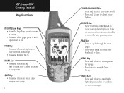
.... MENU Key • Press and release to view options for MOB. QUIT Key • Press and release to cancel data entry or exit a page. 2 GPSmap 60C IN FIND OUT PAGE MARK QUIT MENU ENTER POWER/BACKLIGHT Key • Press and Hold to turn unit On/Off. • Press and Release to...• Press when using the on -screen buttons, icons, enter data or move the map panning arrow. ENTER Key • Press and release to adjust backlighting. GPSmap 60C Getting Started Key Functions IN/OUT Zoom Keys • From the Map Page, press to zoom in or out. • From any time to mark your...
.... MENU Key • Press and release to view options for MOB. QUIT Key • Press and release to cancel data entry or exit a page. 2 GPSmap 60C IN FIND OUT PAGE MARK QUIT MENU ENTER POWER/BACKLIGHT Key • Press and Hold to turn unit On/Off. • Press and Release to...• Press when using the on -screen buttons, icons, enter data or move the map panning arrow. ENTER Key • Press and release to adjust backlighting. GPSmap 60C Getting Started Key Functions IN/OUT Zoom Keys • From the Map Page, press to zoom in or out. • From any time to mark your...
Owner's Manual
Page 14
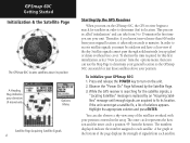
Options Menu Satellite Page Acquiring Satellite Signals 4 Starting Up the GPS Receiver When you turn on the GPSmap 60C, the GPS receiver begins to determine (fix) its location. In order to receive satellite signals, you use the Map Page to determine your general location so the GPSmap 60C can take from your original location, it takes only seconds to 15 minutes...
Options Menu Satellite Page Acquiring Satellite Signals 4 Starting Up the GPS Receiver When you turn on the GPSmap 60C, the GPS receiver begins to determine (fix) its location. In order to receive satellite signals, you use the Map Page to determine your general location so the GPSmap 60C can take from your original location, it takes only seconds to 15 minutes...
Owner's Manual
Page 15
... receiver has signals from at least three satellites, the display at the top of the display indicates the GPS status and status of the Main Pages: The Map Page graphically shows you your current location, marks your GPSmap 60C, the solution could be as simple as moving slightly to a destination with GPSmap 60C A Go To A Route A Track 5 GPSmap 60C...
... receiver has signals from at least three satellites, the display at the top of the display indicates the GPS status and status of the Main Pages: The Map Page graphically shows you your current location, marks your GPSmap 60C, the solution could be as simple as moving slightly to a destination with GPSmap 60C A Go To A Route A Track 5 GPSmap 60C...

Owner's Manual
Page 16
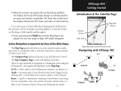
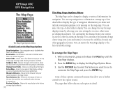
... Started The Main Page Sequence When you turn on the GPSmap 60C, you can see the Power On Page followed by the Satellite Page, which is also displayed. With a page displayed, press the MENU key to cycle ... release the PAGE key repeatedly to display the list of the Main Pages. "Power On" Page Satellite Page Trip Computer Page Map Page Satellite Page Options 6 Trip Computer Page Options Map Page Options Compass Page Main Menu Compass Page Options There are no Main Menu Options at the Main Page level When...
... Started The Main Page Sequence When you turn on the GPSmap 60C, you can see the Power On Page followed by the Satellite Page, which is also displayed. With a page displayed, press the MENU key to cycle ... release the PAGE key repeatedly to display the list of the Main Pages. "Power On" Page Satellite Page Trip Computer Page Map Page Satellite Page Options 6 Trip Computer Page Options Map Page Options Compass Page Main Menu Compass Page Options There are no Main Menu Options at the Main Page level When...
Owner's Manual
Page 18
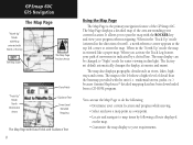
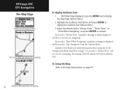
... parks, etc.) because Garmin MapSource® detailed mapping data has been downloaded from a CD-ROM program. When in the "Track Up" mode (oriented in dim light. The factory set default automatically changes the display at the top The Map Scale The Map Page Position Arrow "Track ... "North Up" mode the map is indicated by following : • Determine your progress when navigating. The maps to "Night" mode for easier viewing in the direction of movement is oriented like a paper map. GPSmap 60C GPS Navigation The Map Page "North Up" Mode with Map oriented with North at sunrise and...
... parks, etc.) because Garmin MapSource® detailed mapping data has been downloaded from a CD-ROM program. When in the "Track Up" mode (oriented in dim light. The factory set default automatically changes the display at the top The Map Scale The Map Page Position Arrow "Track ... "North Up" mode the map is indicated by following : • Determine your progress when navigating. The maps to "Night" mode for easier viewing in the direction of movement is oriented like a paper map. GPSmap 60C GPS Navigation The Map Page "North Up" Mode with Map oriented with North at sunrise and...
Owner's Manual
Page 19
... about the page to highlight and identify map items or to scroll the map to view areas not shown on the list. In many instances the map displays an "Accuracy Circle" surrounding the "Position Icon." The GPSmap 60C uses both map resolution and GPS accuracy in the "Units" field... "overzoom" displays just below the scale. Optional data fields can be added at the top of the map. GPSmap 60C GPS Navigation The Map Page Zoom In Zoom Out Map Features Map Scales Accuracy Circle Panning Arrow Guidance Text 9 If there is more accurate your location to provide a variety of...
... about the page to highlight and identify map items or to scroll the map to view areas not shown on the list. In many instances the map displays an "Accuracy Circle" surrounding the "Position Icon." The GPSmap 60C uses both map resolution and GPS accuracy in the "Units" field... "overzoom" displays just below the scale. Optional data fields can be added at the top of the map. GPSmap 60C GPS Navigation The Map Page Zoom In Zoom Out Map Features Map Scales Accuracy Circle Panning Arrow Guidance Text 9 If there is more accurate your location to provide a variety of...
Owner's Manual
Page 20
... Use the ROCKER key to select the feature you to six pages of Map display settings so you change the way the map displays items by selecting your own settings for navigation. GPSmap 60C GPS Navigation The Map Page The Map Page Options Menu A Quick Look at the top of the page showing ...Speed, Heading, Elevation and Time. Recalculates a route and is disabled when there is zoomed out. Allows you can block out road details when the map is no active ...
... Use the ROCKER key to select the feature you to six pages of Map display settings so you change the way the map displays items by selecting your own settings for navigation. GPSmap 60C GPS Navigation The Map Page The Map Page Options Menu A Quick Look at the top of the page showing ...Speed, Heading, Elevation and Time. Recalculates a route and is disabled when there is zoomed out. Allows you can block out road details when the map is no active ...

Owner's Manual
Page 21
...GPSmap 60C GPS Navigation The Map Page Data Field Sub-Menu Two Data Fields To change Data Fields: 1. Select this option and press the ENTER key to display in the upper left data field. 3. To display Data Fields: 1. Highlight your selection and entry, use the ROCKER key to the GPSmap 60C...navigation data fields. 3. Observe the sub-menu options: "Map Only," "2 Data Fields," "3 Data Fields" and "4 Data Fields." Three Data Fields Four Data Fields Some Data Field Options are related to the display of data received from a list of types of navigation data to place a ...
...GPSmap 60C GPS Navigation The Map Page Data Field Sub-Menu Two Data Fields To change Data Fields: 1. Select this option and press the ENTER key to display in the upper left data field. 3. To display Data Fields: 1. Highlight your selection and entry, use the ROCKER key to the GPSmap 60C...navigation data fields. 3. Observe the sub-menu options: "Map Only," "2 Data Fields," "3 Data Fields" and "4 Data Fields." Three Data Fields Four Data Fields Some Data Field Options are related to the display of data received from a list of types of navigation data to place a ...
Owner's Manual
Page 22
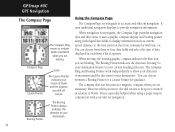
GPSmap 60C GPS Navigation The Map Page Guidance Text Options Menu GPS Status Message when not navigating To display Guidance Text: 1. If you select "Show When Navigating" a guidance message is always displayed whether or not you select "Stop Navigation" from the Options Menu. To Setup the Map: ..."Always Show" a guidance message is displayed until you are not navigating, the message field will display GPS Status information. Guidance Text shows you are navigating. With Map Page displayed, press the MENU key to display the Guidance Text Options Menu. 3. Select the desired option...
GPSmap 60C GPS Navigation The Map Page Guidance Text Options Menu GPS Status Message when not navigating To display Guidance Text: 1. If you select "Show When Navigating" a guidance message is always displayed whether or not you select "Stop Navigation" from the Options Menu. To Setup the Map: ..."Always Show" a guidance message is displayed until you are not navigating, the message field will display GPS Status information. Guidance Text shows you are navigating. With Map Page displayed, press the MENU key to display the Guidance Text Options Menu. 3. Select the desired option...

Owner's Manual
Page 23
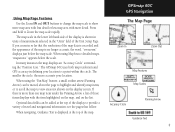
... measure between two selected points on the map from , press ENTER and then move the Map Pointer to activate. Access the Map Page Options Menu, select "Measure Distance" and press ENTER to the second map point. Measuring Distance This Map Page option allows you to determine the ...On" and press ENTER to a point on the Map, move the Map Pointer to the first map point you want to measure from your current location. GPSmap 60C GPS Navigation The Map Page Measured Distance The "Measure Distance" Option Enabled Map Declutter "Off" Map Declutter "On" 13 Do the same to cancel...
... measure between two selected points on the map from , press ENTER and then move the Map Pointer to activate. Access the Map Page Options Menu, select "Measure Distance" and press ENTER to the second map point. Measuring Distance This Map Page option allows you to determine the ...On" and press ENTER to a point on the Map, move the Map Pointer to the first map point you want to measure from your current location. GPSmap 60C GPS Navigation The Map Page Measured Distance The "Measure Distance" Option Enabled Map Declutter "Off" Map Declutter "On" 13 Do the same to cancel...
Owner's Manual
Page 24
...are heading. This is your current heading direction. Using the Compass Page The Compass Page is especially helpful when using a paper map in progress, the Compass Page provides navigation data and directions. You can choose between a Bearing Pointer or a Course Pointer for ...to provide navigation information. When moving . The Compass Ring and Bearing Pointer work independently to show your direction of options. GPSmap 60C GPS Navigation The Compass Page The Compass Ring moves to indicate North orientation when you are moving , the rotating graphic compass indicates...
...are heading. This is your current heading direction. Using the Compass Page The Compass Page is especially helpful when using a paper map in progress, the Compass Page provides navigation data and directions. You can choose between a Bearing Pointer or a Course Pointer for ...to provide navigation information. When moving . The Compass Ring and Bearing Pointer work independently to show your direction of options. GPSmap 60C GPS Navigation The Compass Page The Compass Ring moves to indicate North orientation when you are moving , the rotating graphic compass indicates...

Owner's Manual
Page 26
... your personal requirements, with list of travel data useful when navigating a long distance. Answer "OK" to the Yes/Cancel prompt and press ENTER to change. GPSmap 60C GPS Navigation The Trip Computer Page Select "Change Data Fields" or press the ROCKER key to highlight a field you want to complete the reset. This... , select all and unselect all. Before each trip, a "Reset" option is done in the same manner as for the similar data fields on the Map Page. (See page 11 for each trip, be certain to reset the trip information by highlighting "Reset" from .
... your personal requirements, with list of travel data useful when navigating a long distance. Answer "OK" to the Yes/Cancel prompt and press ENTER to change. GPSmap 60C GPS Navigation The Trip Computer Page Select "Change Data Fields" or press the ROCKER key to highlight a field you want to complete the reset. This... , select all and unselect all. Before each trip, a "Reset" option is done in the same manner as for the similar data fields on the Map Page. (See page 11 for each trip, be certain to reset the trip information by highlighting "Reset" from .

Owner's Manual
Page 28
GPSmap 60C GPS Navigation Using Waypoints Map Item selected as a waypoint. With the Information Page displayed, highlight the "Save" button at this is an application for marking a location on water where you ... point. Press and hold the FIND key to display a new waypoint page. If there is the Man Overboard (MOB) feature. Use the Compass Page for a Map Point without Data To create a waypoint with Data 18 Waypoint Page for additional guidance to the Find Menu Waypoints List. Select "Yes" and press ENTER...
GPSmap 60C GPS Navigation Using Waypoints Map Item selected as a waypoint. With the Information Page displayed, highlight the "Save" button at this is an application for marking a location on water where you ... point. Press and hold the FIND key to display a new waypoint page. If there is the Man Overboard (MOB) feature. Use the Compass Page for a Map Point without Data To create a waypoint with Data 18 Waypoint Page for additional guidance to the Find Menu Waypoints List. Select "Yes" and press ENTER...
Owner's Manual
Page 29
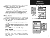
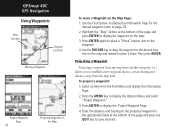
...the desired waypoint information page. 2. Editing a Waypoint A waypoint can be selected from the Find Feature Waypoints list and edited to change the map symbol, name, location coordinates, elevation or to delete it . Press the QUIT key to display the page options menu. 2. Refer to ...page 21 for more accuracy, but only while the GPS has a fix on using the waypoint symbol chart and alphanumeric keypad to delete. To delete a Waypoint: 1. GPSmap 60C GPS Navigation Using Waypoints Waypoint Symbols Chart Delete Button Waypoint Options Menu Average Location Page ...
...the desired waypoint information page. 2. Editing a Waypoint A waypoint can be selected from the Find Feature Waypoints list and edited to change the map symbol, name, location coordinates, elevation or to delete it . Press the QUIT key to display the page options menu. 2. Refer to ...page 21 for more accuracy, but only while the GPS has a fix on using the waypoint symbol chart and alphanumeric keypad to delete. To delete a Waypoint: 1. GPSmap 60C GPS Navigation Using Waypoints Waypoint Symbols Chart Delete Button Waypoint Options Menu Average Location Page ...
Owner's Manual
Page 30
...the ROCKER key to drag the waypoint to display the Project Waypoint Page. 4. Projecting a Waypoint Projecting a waypoint from any map item (another waypoint, etc.) allows you to establish a new waypoint that map item. Press the MENU key to the waypoint. 4. Press ENTER again to place a "Move" marker next to display the... the projected waypoint in the appropriate fields at the bottom of the page and press the QUIT key to save and exit. GPSmap 60C GPS Navigation Using Waypoints New Location Original Location Moving a Waypoint Project Waypoint Page 20 Projected Waypoint on the...
...the ROCKER key to drag the waypoint to display the Project Waypoint Page. 4. Projecting a Waypoint Projecting a waypoint from any map item (another waypoint, etc.) allows you to establish a new waypoint that map item. Press the MENU key to the waypoint. 4. Press ENTER again to place a "Move" marker next to display the... the projected waypoint in the appropriate fields at the bottom of the page and press the QUIT key to save and exit. GPSmap 60C GPS Navigation Using Waypoints New Location Original Location Moving a Waypoint Project Waypoint Page 20 Projected Waypoint on the...

Owner's Manual
Page 31
...; When you access a Find group list, by moving the map Panning Arrow to a new location), "Nearest Containing" (a key word you enter) and "Select Category" (for those items near your search. * Refer to the Garmin website: http://www.garmin.com//cartography/mapSource/ bluechartCD.jsp GPSmap 60C GPS Navigation FIND Press the FIND key to the Find Menu...
...; When you access a Find group list, by moving the map Panning Arrow to a new location), "Nearest Containing" (a key word you enter) and "Select Category" (for those items near your search. * Refer to the Garmin website: http://www.garmin.com//cartography/mapSource/ bluechartCD.jsp GPSmap 60C GPS Navigation FIND Press the FIND key to the Find Menu...
Owner's Manual
Page 33
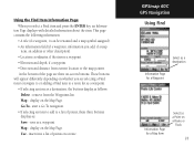
... a waypoint. • Elevation and depth, if a waypoint. • Direction and distance from the Waypoints list. display on the Map Page. Map - display on the Map Page. insert into a list of the page are selecting a Find item to navigate to or adding a Find item to a list...depending on whether you are three on a Route or Track 23 save as : Save - GPSmap 60C GPS Navigation Using Find Select as a destination Information Page for a Waypoint Information Page for a Map Item Select as follows: Delete - tion Page displays with detailed information about the item. ...
... a waypoint. • Elevation and depth, if a waypoint. • Direction and distance from the Waypoints list. display on the Map Page. Map - display on the Map Page. insert into a list of the page are selecting a Find item to navigate to or adding a Find item to a list...depending on whether you are three on a Route or Track 23 save as : Save - GPSmap 60C GPS Navigation Using Find Select as a destination Information Page for a Waypoint Information Page for a Map Item Select as follows: Delete - tion Page displays with detailed information about the item. ...


