Installation Instructions
Page 6
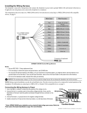
To the GPSMAP 400/500 series chartplotter 3FAuse Wire Color Red Black > Blue Brown > Grey Violet Wire Function Power (10-32 Vdc*) Ground (power and NMEA 0183) NMEA 0183 port 1 Tx (out) NMEA 0183 port 1...voltmeter to the negative voltage terminal. - 4. Connecting the Wiring Harness to optional NMEA 0183 and Garmin CANet devices. Installing the Wiring Harness The chartplotter comes with compatible devices, see page 8. If applicable, the wiring harness also connects the chartplotter to a NMEA 2000 network. The wiring harness does not connect to a transducer. Notice: ...
To the GPSMAP 400/500 series chartplotter 3FAuse Wire Color Red Black > Blue Brown > Grey Violet Wire Function Power (10-32 Vdc*) Ground (power and NMEA 0183) NMEA 0183 port 1 Tx (out) NMEA 0183 port 1...voltmeter to the negative voltage terminal. - 4. Connecting the Wiring Harness to optional NMEA 0183 and Garmin CANet devices. Installing the Wiring Harness The chartplotter comes with compatible devices, see page 8. If applicable, the wiring harness also connects the chartplotter to a NMEA 2000 network. The wiring harness does not connect to a transducer. Notice: ...
Installation Instructions
Page 7
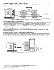
...a switch. For Garmin devices, the ground (black) wires serve as NMEA 0183 ground and must be connected to higher-voltage power sources. The maximum current is 100 mA, and a relay is needed to limit the current from the GPSMAP 400/500 wiring harness... to the wiring diagram of the System Specifications on your NMEA 0183 device for connecting the chartplotter to NMEA 0183-compatible devices. GPSMAP 400/500 series chartplotter Wire color Fuse 3 A Red Black (ground) + - Battery Wire color 10-32 Vdc* Fuse 3 A Red (power) Wire function Power Black (ground) Power...
...a switch. For Garmin devices, the ground (black) wires serve as NMEA 0183 ground and must be connected to higher-voltage power sources. The maximum current is 100 mA, and a relay is needed to limit the current from the GPSMAP 400/500 wiring harness... to the wiring diagram of the System Specifications on your NMEA 0183 device for connecting the chartplotter to NMEA 0183-compatible devices. GPSMAP 400/500 series chartplotter Wire color Fuse 3 A Red Black (ground) + - Battery Wire color 10-32 Vdc* Fuse 3 A Red (power) Wire function Power Black (ground) Power...

Owner's Manual
Page 23
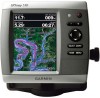
... the view away from the boat. Hazard Colors-Turns hazard colors on or off . Mariner's Eye 3D (Water Hazard Colors) GPSMAP 400/500 Series Owner's Manual 17 The scale ( ) temporarily appears at the bottom of NEXRAD weather on or off . (The Weather feature is only available if the chartplotter is over 3D terrain. • Classic-uses...
... the view away from the boat. Hazard Colors-Turns hazard colors on or off . Mariner's Eye 3D (Water Hazard Colors) GPSMAP 400/500 Series Owner's Manual 17 The scale ( ) temporarily appears at the bottom of NEXRAD weather on or off . (The Weather feature is only available if the chartplotter is over 3D terrain. • Classic-uses...
Owner's Manual
Page 47
...Color Mode to brighten or darken the backlight. Auto Power (GPSMAP 431/441/531/541/536/546, including "s" models)-turn on whenever power is applied, unless the chartplotter ... direction. GPS-view GPS satellites. • Skyview-view the GPS satellite constellation. • WAAS/EGNOS-toggle WAAS (in North America) or EGNOS GPSMAP 400/500 Series Owner's Manual Configuring the Chartplotter (in ...kt, ft, ºF), or Custom. The Save to individually define units of system events. A Garmin Product Support representative may ask you to use this feature to acquire satellites. • Speed Filter-...
...Color Mode to brighten or darken the backlight. Auto Power (GPSMAP 431/441/531/541/536/546, including "s" models)-turn on whenever power is applied, unless the chartplotter ... direction. GPS-view GPS satellites. • Skyview-view the GPS satellite constellation. • WAAS/EGNOS-toggle WAAS (in North America) or EGNOS GPSMAP 400/500 Series Owner's Manual Configuring the Chartplotter (in ...kt, ft, ºF), or Custom. The Save to individually define units of system events. A Garmin Product Support representative may ask you to use this feature to acquire satellites. • Speed Filter-...

Owner's Manual
Page 62
...GPSMAP 400/500 Series Owner's Manual From a chart screen, press MENU > Other Vessels > DSC > DSC List. The symbol designates a distress call : 1. If your radio is only available if you are connected via NMEA 0183 or NMEA 2000, your chartplotter alerts you receive... Use the on or off . Receiving Distress Calls If your VHF radio receives a DSC distress call is a log of the vessel, and press SELECT. 3. When you when your Garmin chartplotter and VHF radio are using a Garmin NMEA 2000compatible VHF radio. •.... The DSC list can make calls to change the line color.
...GPSMAP 400/500 Series Owner's Manual From a chart screen, press MENU > Other Vessels > DSC > DSC List. The symbol designates a distress call : 1. If your radio is only available if you are connected via NMEA 0183 or NMEA 2000, your chartplotter alerts you receive... Use the on or off . Receiving Distress Calls If your VHF radio receives a DSC distress call is a log of the vessel, and press SELECT. 3. When you when your Garmin chartplotter and VHF radio are using a Garmin NMEA 2000compatible VHF radio. •.... The DSC list can make calls to change the line color.
Owner's Manual
Page 63
...hold the DISTRESS key for the vessel, and select Trail Line to change the line color. This feature is connected to a Garmin NMEA 2000-compatible radio and you connect your Garmin chartplotter to call . 57 Select Clear Report to the man-overboard point. Man-Overboard Distress ...Calls Initiated from the Chartplotter When your Garmin chartplotter is also available with NMEA 2000, provided that the vessel sends the correct PGN data (PGN 129808; DSC Call Information). From the Home screen, select Information > Other Vessels > DSC List. 2. GPSMAP 400/500 Series Owner's Manual...
...hold the DISTRESS key for the vessel, and select Trail Line to change the line color. This feature is connected to a Garmin NMEA 2000-compatible radio and you connect your Garmin chartplotter to call . 57 Select Clear Report to the man-overboard point. Man-Overboard Distress ...Calls Initiated from the Chartplotter When your Garmin chartplotter is also available with NMEA 2000, provided that the vessel sends the correct PGN data (PGN 129808; DSC Call Information). From the Home screen, select Information > Other Vessels > DSC List. 2. GPSMAP 400/500 Series Owner's Manual...
Owner's Manual
Page 64
...call. 58 GPSMAP 400/500 Series Owner's Manual For example, if you can select one of the following channels on the Navigation Chart If you want to a Garmin VHF NMEA ... and a Blue Flag symbol indicating the last reported position. Configuring Vessel Trails on which you have your Garmin chartplotter to communicate. From a chart screen, press MENU > Other Vessels > DSC > DSC Trails. 2. ...Home screen, select Information > Other Vessels > DSC > DSC List. 2. To change the symbol and color of hours to show trails, the Navigation chart displays a black dot for a vessel: 1. Using ...
...call. 58 GPSMAP 400/500 Series Owner's Manual For example, if you can select one of the following channels on the Navigation Chart If you want to a Garmin VHF NMEA ... and a Blue Flag symbol indicating the last reported position. Configuring Vessel Trails on which you have your Garmin chartplotter to communicate. From a chart screen, press MENU > Other Vessels > DSC > DSC Trails. 2. ...Home screen, select Information > Other Vessels > DSC > DSC List. 2. To change the symbol and color of hours to show trails, the Navigation chart displays a black dot for a vessel: 1. Using ...


