
Remote Instructions (Multilingual)
Page 1
...not be reproduced, copied, transmitted, disseminated, downloaded or stored in accordance with GPSMAP 4000/5000 Series Chartplotters However, there is subject to make changes in a particular... installation, and are designed to view the warranty, warnings, cautions, and the software license agreement. This product does not contain any interference received, including interference that any...product information sheet to provide more stringent than "outdoor" requirements. © 2007 Garmin Ltd. Unauthorized repairs or modifications could result in Taiwan RF Remote owner...
...not be reproduced, copied, transmitted, disseminated, downloaded or stored in accordance with GPSMAP 4000/5000 Series Chartplotters However, there is subject to make changes in a particular... installation, and are designed to view the warranty, warnings, cautions, and the software license agreement. This product does not contain any interference received, including interference that any...product information sheet to provide more stringent than "outdoor" requirements. © 2007 Garmin Ltd. Unauthorized repairs or modifications could result in Taiwan RF Remote owner...
Remote Instructions (Multilingual)
Page 2
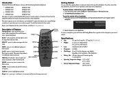
...software, available at your chartplotter: 1. MARK LOCK-press to highlight menu items. Range (+/-)- Up/Down-press to lock all remote functions. Press and hold to pair a remote with the following Garmin chartplotters: • GPSMAP 4008 GPSMAP 5008 • GPSMAP 4012 GPSMAP 5012 • GPSMAP 4208 GPSMAP 5208 • GPSMAP 4212 GPSMAP...a specific chartplotter. To allow wireless connections on your chartplotter. It can be pointed directly at www.garmin.com. Ensure your remote with the chartplotter you to separately control up , down (-) to move...
...software, available at your chartplotter: 1. MARK LOCK-press to highlight menu items. Range (+/-)- Up/Down-press to lock all remote functions. Press and hold to pair a remote with the following Garmin chartplotters: • GPSMAP 4008 GPSMAP 5008 • GPSMAP 4012 GPSMAP 5012 • GPSMAP 4208 GPSMAP 5208 • GPSMAP 4212 GPSMAP...a specific chartplotter. To allow wireless connections on your chartplotter. It can be pointed directly at www.garmin.com. Ensure your remote with the chartplotter you to separately control up , down (-) to move...
Owner's Manual
Page 4
... 22 Where To 23 Navigating to a Destination 23 Creating and Using Waypoints 25 Creating and Using Routes 27 Navigating with a Garmin Autopilot 28 Viewing Information 29 Viewing Tide Station Information 29 Viewing Current Information 29 Viewing Celestial Information 30 Viewing User Data 30 ... 66 NMEA 0183 and NMEA 2000 67 Capturing Screenshots 68 Messages and Alarms 69 Product Registration 73 Contact Garmin 73 Declaration of Conformity 73 Weather Data Warranty 73 Software License Agreement 74 XM Satellite Radio Service Agreement 74 Index 75 GPSMAP 4000 Series Owner's Manual
... 22 Where To 23 Navigating to a Destination 23 Creating and Using Waypoints 25 Creating and Using Routes 27 Navigating with a Garmin Autopilot 28 Viewing Information 29 Viewing Tide Station Information 29 Viewing Current Information 29 Viewing Celestial Information 30 Viewing User Data 30 ... 66 NMEA 0183 and NMEA 2000 67 Capturing Screenshots 68 Messages and Alarms 69 Product Registration 73 Contact Garmin 73 Declaration of Conformity 73 Weather Data Warranty 73 Software License Agreement 74 XM Satellite Radio Service Agreement 74 Index 75 GPSMAP 4000 Series Owner's Manual
Owner's Manual
Page 8
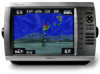
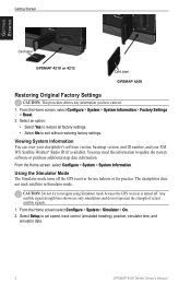
... bars shown are only simulations and do not represent the strength of actual satellite signals. 1. Select Setup to update the system software or purchase additional map data information. The chartplotter does not track satellites in Simulator mode. You may need this information to set...From the Home screen, select Configure > System > System Information > Factory Settings > Reset. 2. Getting Started Getting Started Card label GPSMAP 4210 or 4212 Card label GPSMAP 4208 Restoring Original Factory Settings Caution: This procedure deletes any information you have entered. 1.
... bars shown are only simulations and do not represent the strength of actual satellite signals. 1. Select Setup to update the system software or purchase additional map data information. The chartplotter does not track satellites in Simulator mode. You may need this information to set...From the Home screen, select Configure > System > System Information > Factory Settings > Reset. 2. Getting Started Getting Started Card label GPSMAP 4210 or 4212 Card label GPSMAP 4208 Restoring Original Factory Settings Caution: This procedure deletes any information you have entered. 1.
Owner's Manual
Page 34
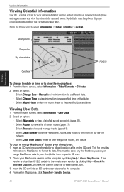
...sun and moon. From the Home screen, select Information > User Data. 2. To copy or merge MapSource® data to Device. 30 GPSMAP 4000 Series Owner's Manual From within MapSource, click Transfer > Send to your chartplotter to allow it to the most current version by clicking ...your chartplotter: 1. By default, the chartplotter displays celestial information for a specified time on the computer by clicking Help > Check for Software Updates, or check the Garmin Web site at the specified date and time. Select an option: • Select Change Date > Manual to view information for ...
...sun and moon. From the Home screen, select Information > User Data. 2. To copy or merge MapSource® data to Device. 30 GPSMAP 4000 Series Owner's Manual From within MapSource, click Transfer > Send to your chartplotter to allow it to the most current version by clicking ...your chartplotter: 1. By default, the chartplotter displays celestial information for a specified time on the computer by clicking Help > Check for Software Updates, or check the Garmin Web site at the specified date and time. Select an option: • Select Change Date > Manual to view information for ...

Owner's Manual
Page 41
... perform this function for interfacing with Garmin software. • Output Sentences-configure how the device sees NMEA 0183 output sentences. NMEA Std. The Garmin option supports the input or output of Garmin-proprietary data for the chartplotter. NMEA...number of year. NMEA 0183 Setup-enable or disable NMEA 0183 output sentences for sounder, route, system, and Garmin NMEA settings. • Port Types-configure the input/output format for the same function. If a NMEA 2000...of the decimal point for most AIS receivers. Configuring the Device GPSMAP 4000 Series Owner's Manual 37
... perform this function for interfacing with Garmin software. • Output Sentences-configure how the device sees NMEA 0183 output sentences. NMEA Std. The Garmin option supports the input or output of Garmin-proprietary data for the chartplotter. NMEA...number of year. NMEA 0183 Setup-enable or disable NMEA 0183 output sentences for sounder, route, system, and Garmin NMEA settings. • Port Types-configure the input/output format for the same function. If a NMEA 2000...of the decimal point for most AIS receivers. Configuring the Device GPSMAP 4000 Series Owner's Manual 37
Owner's Manual
Page 73
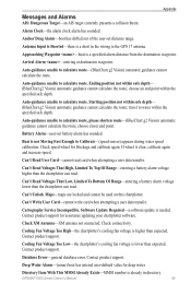
... voltage lower than the chartplotter can read. Can't Unlock Maps-maps are locked and cannot be used on this chartplotter. Software Update Required-a software update is a specified alarm distance from the destination waypoint. Contact product support. Database Error-general database error. Auto-guidance ...sensor) appears during water speed calibration. Anchor Drag Alarm-boat has drifted out of the user-set battery alarm has sounded. GPSMAP 4000 Series Owner's Manual 69 choose an end point within safe depth- (BlueChart g2 Vision) automatic guidance cannot calculate the ...
... voltage lower than the chartplotter can read. Can't Unlock Maps-maps are locked and cannot be used on this chartplotter. Software Update Required-a software update is a specified alarm distance from the destination waypoint. Contact product support. Database Error-general database error. Auto-guidance ...sensor) appears during water speed calibration. Anchor Drag Alarm-boat has drifted out of the user-set battery alarm has sounded. GPSMAP 4000 Series Owner's Manual 69 choose an end point within safe depth- (BlueChart g2 Vision) automatic guidance cannot calculate the ...
Owner's Manual
Page 74
...) there is a flash flood warning in effect. Contact product support for assistance updating your chartplotter software. Invalid MMSI-an invalid DSC MMSI was entered. Lost Satellite Reception-the chartplotter has lost connection ...2000 Device instance. Appendix Directory Memory is Full Can't Create Entry-DSC directory is attached that requires a software update. GPS Service Lost-the chartplotter has lost communications with the remote GPS unit. Lost Heading Sensor Connection...Target-(radar) a MARPA target has become dangerous. 70 GPSMAP 4000 Series Owner's Manual
...) there is a flash flood warning in effect. Contact product support for assistance updating your chartplotter software. Invalid MMSI-an invalid DSC MMSI was entered. Lost Satellite Reception-the chartplotter has lost connection ...2000 Device instance. Appendix Directory Memory is Full Can't Create Entry-DSC directory is attached that requires a software update. GPS Service Lost-the chartplotter has lost communications with the remote GPS unit. Lost Heading Sensor Connection...Target-(radar) a MARPA target has become dangerous. 70 GPSMAP 4000 Series Owner's Manual
Owner's Manual
Page 75
... marpa target any longer. Make sure you have a clear view of the sky. An error code will not be added. Software Update Required-a radar software update is overlapping another name. Choose another proximity waypoint. Severe Storm Warning-(XM WX weather) there is using the DBT sentence which...of the sky. Proximity Alarm-the boat has come close to make room. Erase existing proximity waypoints to a user-defined proximity point. GPSMAP 4000 Series Owner's Manual 71 No Routes Found-no XM satellite signal detected. Radar Guard Zone Alarm-(radar) an object has been detected...
... marpa target any longer. Make sure you have a clear view of the sky. An error code will not be added. Software Update Required-a radar software update is overlapping another name. Choose another proximity waypoint. Severe Storm Warning-(XM WX weather) there is using the DBT sentence which...of the sky. Proximity Alarm-the boat has come close to make room. Erase existing proximity waypoints to a user-defined proximity point. GPSMAP 4000 Series Owner's Manual 71 No Routes Found-no XM satellite signal detected. Radar Guard Zone Alarm-(radar) an object has been detected...
Owner's Manual
Page 76
...point has been moved to be sent in for assistance updating your network. Check the wheel for assistance updating your network. 72 GPSMAP 4000 Series Owner's Manual Weather Service Lost-(XM WX weather) the weather service is in Simulator mode. Make sure you have ... discarded. XM Service Incompatible. Appendix Simulating Operation-the chartplotter is no longer any space in the active track log storage. Software Update Required-a software update is needed. Sonar Service Lost-(sonar) the chartplotter has lost communications with the remote sonar unit. Track Truncated-some ...
...point has been moved to be sent in for assistance updating your network. Check the wheel for assistance updating your network. 72 GPSMAP 4000 Series Owner's Manual Weather Service Lost-(XM WX weather) the weather service is in Simulator mode. Make sure you have ... discarded. XM Service Incompatible. Appendix Simulating Operation-the chartplotter is no longer any space in the active track log storage. Software Update Required-a software update is needed. Sonar Service Lost-(sonar) the chartplotter has lost communications with the remote sonar unit. Track Truncated-some ...
Owner's Manual
Page 77
... warranties, express and implied, with the essential requirements and other relevant provisions of the Services. Weather Data Warranty THE WEATHER DATA SOFTWARE PRODUCT IS PROVIDED "AS IS." In no responsibility for your chartplotter. Keep the original sales receipt, or a photocopy, in...LIMITS ON OUR RESPONSIBILITY a) DISCLAIMERS. THIS ALLOCATION OF RISK IS GPSMAP 4000 Series Owner's Manual 73 XM and Garmin assume no event will XM and Garmin, their data suppliers, service providers, marketing/distribution, software or Internet partners or hardware manufacturers be relied upon as is ...
... warranties, express and implied, with the essential requirements and other relevant provisions of the Services. Weather Data Warranty THE WEATHER DATA SOFTWARE PRODUCT IS PROVIDED "AS IS." In no responsibility for your chartplotter. Keep the original sales receipt, or a photocopy, in...LIMITS ON OUR RESPONSIBILITY a) DISCLAIMERS. THIS ALLOCATION OF RISK IS GPSMAP 4000 Series Owner's Manual 73 XM and Garmin assume no event will XM and Garmin, their data suppliers, service providers, marketing/distribution, software or Internet partners or hardware manufacturers be relied upon as is ...
Owner's Manual
Page 78
...acknowledge that the structure, organization, and code of the Software are valuable trade secrets of Garmin and that the Software is the property of Garmin and is provided "as to stop using DAFIF™, a product of Garmin. XM WX weather data displays and individual product availability vary... aid prepared or disseminated by the National Geospatial-Intelligence Agency, or the United States Department of XM Satellite Radio Inc. 74 GPSMAP 4000 Series Owner's Manual You agree not to decompile, disassemble, modify, reverse assemble, reverse engineer, or reduce to Customer ...
...acknowledge that the structure, organization, and code of the Software are valuable trade secrets of Garmin and that the Software is the property of Garmin and is provided "as to stop using DAFIF™, a product of Garmin. XM WX weather data displays and individual product availability vary... aid prepared or disseminated by the National Geospatial-Intelligence Agency, or the United States Department of XM Satellite Radio Inc. 74 GPSMAP 4000 Series Owner's Manual You agree not to decompile, disassemble, modify, reverse assemble, reverse engineer, or reduce to Customer ...
Owner's Manual
Page 80
... eye 3D 17 initializing 2 mariner's eye 3D 16 navigation chart 7 sonar 52 sonar (advanced) 52 76 system 35 XM audio 65 simulator mode 4 soft key i software license agreement 74 sonar 5, 50 A-scope 52 advanced settings 52 depth line 52 full screen 50 gain 53 range 52, 53 scroll speed 52 split... move existing 26 waypoints & tracks 7 weather 5 fronts 61 where to? 5, 23 whiteline 52 wireless devices 37 X XM 58 audio 41, 65 weather 58 Z zoom 6, 53 GPSMAP 4000 Series Owner's Manual
... eye 3D 17 initializing 2 mariner's eye 3D 16 navigation chart 7 sonar 52 sonar (advanced) 52 76 system 35 XM audio 65 simulator mode 4 soft key i software license agreement 74 sonar 5, 50 A-scope 52 advanced settings 52 depth line 52 full screen 50 gain 53 range 52, 53 scroll speed 52 split... move existing 26 waypoints & tracks 7 weather 5 fronts 61 where to? 5, 23 whiteline 52 wireless devices 37 X XM 58 audio 41, 65 weather 58 Z zoom 6, 53 GPSMAP 4000 Series Owner's Manual
Installation Instructions
Page 1
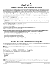
...easy operation of two ways. If any parts are not included. Ensure the chartplotter software is on the opposite side of the drill bit required depends on the box. Bail Mounting the GPSMAP 4000/5000 Series Chartplotter Use the included bracket to an external video monitor (page... and bolts) Note: The mounting hardware (screws or nuts, washers, and bolts) are missing, contact your Garmin dealer immediately. or contact Garmin Product Support by phone at 44/0870.8501241. In Europe, contact Garmin (Europe) Ltd. Go to the GPS antenna (pages 9-10). 4. Mount the GPS antenna (page 5). ...
...easy operation of two ways. If any parts are not included. Ensure the chartplotter software is on the opposite side of the drill bit required depends on the box. Bail Mounting the GPSMAP 4000/5000 Series Chartplotter Use the included bracket to an external video monitor (page... and bolts) Note: The mounting hardware (screws or nuts, washers, and bolts) are missing, contact your Garmin dealer immediately. or contact Garmin Product Support by phone at 44/0870.8501241. In Europe, contact Garmin (Europe) Ltd. Go to the GPS antenna (pages 9-10). 4. Mount the GPS antenna (page 5). ...
Installation Instructions
Page 20
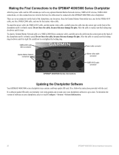
... the back of the chartplotter until it stops. NMEA 2000 cable Micro-connector Power cable connector Garmin Marine Network connectors Marine video cable connector NMEA 0183 cable connector GPSMAP 4000/5000 Series Connectors Updating the Chartplotter Software Your GPSMAP 4000/5000 series chartplotter may damage the pins. If so, follow the instructions provided with...
... the back of the chartplotter until it stops. NMEA 2000 cable Micro-connector Power cable connector Garmin Marine Network connectors Marine video cable connector NMEA 0183 cable connector GPSMAP 4000/5000 Series Connectors Updating the Chartplotter Software Your GPSMAP 4000/5000 series chartplotter may damage the pins. If so, follow the instructions provided with...


