Installation Instructions
Page 5
...secure the cable to cure for 24 hours. Some transducers are only compatible with either the GPSMAP 525/535/545/555/526/536/546/556 or with non "s" models compatible with 400-...in the epoxy, turning the transducer to avoid damage while using a temperature-sensing transducer, the temperature displayed reflects the hull temperature. Temporarily seal the test device to use a higher gain setting. Weight the ... hull with caulking or RTV sealer, and fill the test device with water or a light mineral oil. Lightly sand the surface of the hull and the face of two-part, slow-cure epoxy ...
...secure the cable to cure for 24 hours. Some transducers are only compatible with either the GPSMAP 525/535/545/555/526/536/546/556 or with non "s" models compatible with 400-...in the epoxy, turning the transducer to avoid damage while using a temperature-sensing transducer, the temperature displayed reflects the hull temperature. Temporarily seal the test device to use a higher gain setting. Weight the ... hull with caulking or RTV sealer, and fill the test device with water or a light mineral oil. Lightly sand the surface of the hull and the face of two-part, slow-cure epoxy ...
Owner's Manual
Page 9
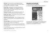
...if an AIS vessel is on track to intersect the Safe Zone around your boat. GPSMAP 400/500 Series Owner's Manual Getting Started Adjusting the Backlight 1. Press and release the Power key.... Press left or right on the Rocker to automatically adjust the backlight based on ambient light, select Auto Backlight (automatic backlight is automatically set the time zone you want to calibrate...units of measure for your boat (page 55). Shallow Water Alarm-only available if you want displayed for more information. Select Yes or No. Refer to your boat specifications for your boat (page...
...if an AIS vessel is on track to intersect the Safe Zone around your boat. GPSMAP 400/500 Series Owner's Manual Getting Started Adjusting the Backlight 1. Press and release the Power key.... Press left or right on the Rocker to automatically adjust the backlight based on ambient light, select Auto Backlight (automatic backlight is automatically set the time zone you want to calibrate...units of measure for your boat (page 55). Shallow Water Alarm-only available if you want displayed for more information. Select Yes or No. Refer to your boat specifications for your boat (page...
Owner's Manual
Page 13
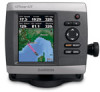
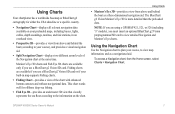
...-provides a view from the Home screen, select Charts > Navigation Chart. Note: If you are using a GPSMAP 421, 521, or 526 (including "s" models), you use a BlueChart g2 Vision SD card or if your built...works well for either the USA shoreline or a specific country. • Navigation Chart-displays all relevant navigation data available on the chart. Fishing charts are available only if ...insert an optional BlueChart g2 Vision preprogrammed SD card to your preloaded maps, including buoys, lights, cables, depth soundings, marinas, and tide stations, in map supports Fishing charts. &#...
...-provides a view from the Home screen, select Charts > Navigation Chart. Note: If you are using a GPSMAP 421, 521, or 526 (including "s" models), you use a BlueChart g2 Vision SD card or if your built...works well for either the USA shoreline or a specific country. • Navigation Chart-displays all relevant navigation data available on the chart. Fishing charts are available only if ...insert an optional BlueChart g2 Vision preprogrammed SD card to your preloaded maps, including buoys, lights, cables, depth soundings, marinas, and tide stations, in map supports Fishing charts. &#...

Owner's Manual
Page 19
... a BlueChart g2 Vision card)-identifies a selected depth. The contour is large, medium, or small as your boat icon on the chart. GPSMAP 400/500 Series Owner's Manual 13 Using Charts Symbols-changes symbol preferences. • Navaid Size-adjusts the size of the navaid symbols shown... the sector in which a navigational light is selected). Selecting Auto filters out light sectors, depending on the zoom level. • Chart Borders-turns chart borders on or off . Heading Line-draws an extension line from the g2 Vision chart. World Map-displays a basic world map or satellite ...
... a BlueChart g2 Vision card)-identifies a selected depth. The contour is large, medium, or small as your boat icon on the chart. GPSMAP 400/500 Series Owner's Manual 13 Using Charts Symbols-changes symbol preferences. • Navaid Size-adjusts the size of the navaid symbols shown... the sector in which a navigational light is selected). Selecting Auto filters out light sectors, depending on the zoom level. • Chart Borders-turns chart borders on or off . Heading Line-draws an extension line from the g2 Vision chart. World Map-displays a basic world map or satellite ...

Owner's Manual
Page 22
...Colors) Range Rings-toggles the range rings on or off . Style-Selects how chart data is displayed over the navaid, the navaid is highlighted. 2. Blue indicates deep water, yellow is shallow water...Mariner's Eye 3D screen, press MENU. The Off setting shows the land as beacons, lights, and obstructions: 1. Mariner's Eye 3D Settings To access additional settings or options from ... select MENU > Chart Appearance. The On setting indicates shallow water and land with a color scale. GPSMAP 400/500 Series Owner's Manual Press SELECT to Waypoints & Tracks, Other Vessels, and Data Bars, ...
...Colors) Range Rings-toggles the range rings on or off . Style-Selects how chart data is displayed over the navaid, the navaid is highlighted. 2. Blue indicates deep water, yellow is shallow water...Mariner's Eye 3D screen, press MENU. The Off setting shows the land as beacons, lights, and obstructions: 1. Mariner's Eye 3D Settings To access additional settings or options from ... select MENU > Chart Appearance. The On setting indicates shallow water and land with a color scale. GPSMAP 400/500 Series Owner's Manual Press SELECT to Waypoints & Tracks, Other Vessels, and Data Bars, ...

Owner's Manual
Page 24
...the satellite photos will cover both portions of the Fishing Chart screen, select MENU > Chart Setup (page 11). Navaids-displays navigational aids, such as beacons, lights, and obstructions. Enabling High Resolution Satellite Imagery You can overlay high-resolution satellite images on the land, sea, or... both land and water. 18 GPSMAP 400/500 Series Owner's Manual To access additional settings or options from the Fishing ...
...the satellite photos will cover both portions of the Fishing Chart screen, select MENU > Chart Setup (page 11). Navaids-displays navigational aids, such as beacons, lights, and obstructions. Enabling High Resolution Satellite Imagery You can overlay high-resolution satellite images on the land, sea, or... both land and water. 18 GPSMAP 400/500 Series Owner's Manual To access additional settings or options from the Fishing ...

