Technical Reference for Garmin NMEA 2000 Products
Page 3
...configuration information for Garmin NMEA 2000 Products iii Technical Reference for the following products: ◦ GPSMAP® 4000/5000/6000/7000 Series chartplotters ◦ GPSMAP 700 Series chartplotters ◦ GPSMAP 4x1/5x1/5x6 Series chartplotters ◦ GMI™ 10 ◦ GPS 17x ◦... last two sections provide Parameter Group Number (PGN) information for Garmin chartplotters and marine instruments as well as configuration and PGN information for in the installation instructions provided with Garmin NMEA 2000-certified displays and sensors. • The first section...
...configuration information for Garmin NMEA 2000 Products iii Technical Reference for the following products: ◦ GPSMAP® 4000/5000/6000/7000 Series chartplotters ◦ GPSMAP 700 Series chartplotters ◦ GPSMAP 4x1/5x1/5x6 Series chartplotters ◦ GMI™ 10 ◦ GPS 17x ◦... last two sections provide Parameter Group Number (PGN) information for Garmin chartplotters and marine instruments as well as configuration and PGN information for in the installation instructions provided with Garmin NMEA 2000-certified displays and sensors. • The first section...
Technical Reference for Garmin NMEA 2000 Products
Page 4
...)...19 GWS 10 (Garmin Wind Sensor)...20 GHP 10 (Marine Autopilot System)...20 GXM 51...21 VHF 200...21 VHF 300...21 AIS 300...22 AIS 600...22 NMEA 2000-Certified Sensor Configuration Information...23 GPS 17x (GPS Antenna)...23 GFS 10 (Garmin Fuel Sensor)...24 GRA 10 (Garmin Rudder Angle Adapter)...26... GET 10 (Garmin Engine Tilt Adapter...
...)...19 GWS 10 (Garmin Wind Sensor)...20 GHP 10 (Marine Autopilot System)...20 GXM 51...21 VHF 200...21 VHF 300...21 AIS 300...22 AIS 600...22 NMEA 2000-Certified Sensor Configuration Information...23 GPS 17x (GPS Antenna)...23 GFS 10 (Garmin Fuel Sensor)...24 GRA 10 (Garmin Rudder Angle Adapter)...26... GET 10 (Garmin Engine Tilt Adapter...
Technical Reference for Garmin NMEA 2000 Products
Page 22
... Receive 059392 059904 060928 126208 127489 127497 127505 127505 Fluid Level (when calibrated using a Garmin chartplotter or marine instrument) GRA 10 (Garmin Rudder Angle Adapter) Transmit Receive 059392 ISO Acknowledgment 059392 060928 ISO Address Claim 059904 126208 NMEA - GPS 17x (GPS Antenna) Transmit Receive 059392 060928 126208 126464 126992 126996 129025 129026 129029 129539 129540...
... Receive 059392 059904 060928 126208 127489 127497 127505 127505 Fluid Level (when calibrated using a Garmin chartplotter or marine instrument) GRA 10 (Garmin Rudder Angle Adapter) Transmit Receive 059392 ISO Acknowledgment 059392 060928 ISO Address Claim 059904 126208 NMEA - GPS 17x (GPS Antenna) Transmit Receive 059392 060928 126208 126464 126992 126996 129025 129026 129029 129539 129540...
Technical Reference for Garmin NMEA 2000 Products
Page 28
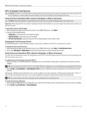
...10 is shown on the GFS 10 to help differentiate among multiple GFS 10 devices. 2. Using Fuel-Level Information With a Garmin Chartplotter or Marine Instrument To receive fuel-level information, connect the wiring harness on the NMEA 2000 device configuration screen to the fuel gauge or... screen on the unit to specify which speed sensor is used on your NMEA 2000 device, select Menu > Fuel Economy Source. 2. Select either GPS Speed or Water Speed to all available fuel-level instruments and sources. For example, entering five calibration points (empty tank, 1/4 tank, 1/2 tank...
...10 is shown on the GFS 10 to help differentiate among multiple GFS 10 devices. 2. Using Fuel-Level Information With a Garmin Chartplotter or Marine Instrument To receive fuel-level information, connect the wiring harness on the NMEA 2000 device configuration screen to the fuel gauge or... screen on the unit to specify which speed sensor is used on your NMEA 2000 device, select Menu > Fuel Economy Source. 2. Select either GPS Speed or Water Speed to all available fuel-level instruments and sources. For example, entering five calibration points (empty tank, 1/4 tank, 1/2 tank...
Important Safety and Product Information
Page 2
Battery Warnings Your GPS unit may use a combination of governmental and private data ...Do not remove or attempt to remove the non-userreplaceable battery. • When disposing of Garmin is to the consumer. See www.garmin.com/prop65 for any discrepancies or questions before continuing navigation. • Use the electronic chart ... Safety and Product Information Warnings Failure to us at a reasonable cost. Official government charts and notices to mariners contain all information needed to the State of certain electronics. This Notice is moving could cause an accident ...
Battery Warnings Your GPS unit may use a combination of governmental and private data ...Do not remove or attempt to remove the non-userreplaceable battery. • When disposing of Garmin is to the consumer. See www.garmin.com/prop65 for any discrepancies or questions before continuing navigation. • Use the electronic chart ... Safety and Product Information Warnings Failure to us at a reasonable cost. Official government charts and notices to mariners contain all information needed to the State of certain electronics. This Notice is moving could cause an accident ...
Owner's Manual
Page 4
... Garmin iv Getting Started 1 Unit Overview 1 Turning the Unit On or Off 2 Initializing Unit Settings 2 Adjusting the Backlight 3 Using the Keypad 4 Acquiring GPS Satellite... Signals 4 Using Simulator Mode 5 Viewing System Information 5 Restoring the Original Factory Settings 5 Inserting and Removing SD Cards 5 Understanding the Home Screen 6 Using Charts 7 Using the Navigation Chart 7 Changing the Navigation Chart Settings 11 Using the Split Navigation Chart 14 Using Perspective 3D 14 Using Mariner...Garmin Autopilot 30 ii GPSMAP 400/500 Series Owner's Manual
... Garmin iv Getting Started 1 Unit Overview 1 Turning the Unit On or Off 2 Initializing Unit Settings 2 Adjusting the Backlight 3 Using the Keypad 4 Acquiring GPS Satellite... Signals 4 Using Simulator Mode 5 Viewing System Information 5 Restoring the Original Factory Settings 5 Inserting and Removing SD Cards 5 Understanding the Home Screen 6 Using Charts 7 Using the Navigation Chart 7 Changing the Navigation Chart Settings 11 Using the Split Navigation Chart 14 Using Perspective 3D 14 Using Mariner...Garmin Autopilot 30 ii GPSMAP 400/500 Series Owner's Manual
Owner's Manual
Page 36
...BlueChart g2 Vision preprogrammed SD cards allow you to detailed marine charting, BlueChart g2 Vision has the following features: • Mariner's Eye 3D-provides a view from exposure to sun...data. Note: You cannot transfer BlueChart g2 Vision data from static electricity. GPSMAP 400/500 Series Owner's Manual The BlueChart g2 Vision Mariner's Eye 3D is more detailed than the preloaded data (page 15). ...data cards are susceptible to damage from the SD card to the card. Navigating with a Garmin Autopilot When you start any type of navigation (Go To, Route To, Guide To, or Follow ...
...BlueChart g2 Vision preprogrammed SD cards allow you to detailed marine charting, BlueChart g2 Vision has the following features: • Mariner's Eye 3D-provides a view from exposure to sun...data. Note: You cannot transfer BlueChart g2 Vision data from static electricity. GPSMAP 400/500 Series Owner's Manual The BlueChart g2 Vision Mariner's Eye 3D is more detailed than the preloaded data (page 15). ...data cards are susceptible to damage from the SD card to the card. Navigating with a Garmin Autopilot When you start any type of navigation (Go To, Route To, Guide To, or Follow ...

Owner's Manual
Page 51
...are available only if you to enter the projected heading time for collision avoidance, and can view the AIS signal status, MMSI, GPS speed, GPS heading, and other information that appears using a trail. Heading-allows you use a BlueChart g2 Vision SD card or if your...Press SELECT. Use the Rocker to all 3D chart views. 1. Press SELECT. 4. Select Navigation Chart, Fishing Chart, Perspective 3D, or Mariner's Eye 3D. GPSMAP 400/500 Series Owner's Manual 45 Viewing Information about a Targeted AIS Vessel You can be customized. Select AIS Vessel. Deactivating a Target ...
...are available only if you to enter the projected heading time for collision avoidance, and can view the AIS signal status, MMSI, GPS speed, GPS heading, and other information that appears using a trail. Heading-allows you use a BlueChart g2 Vision SD card or if your...Press SELECT. Use the Rocker to all 3D chart views. 1. Press SELECT. 4. Select Navigation Chart, Fishing Chart, Perspective 3D, or Mariner's Eye 3D. GPSMAP 400/500 Series Owner's Manual 45 Viewing Information about a Targeted AIS Vessel You can be customized. Select AIS Vessel. Deactivating a Target ...
Owner's Manual
Page 79
... clock 52 collision 55 deep water 53 engine gauge 33 fish 53 fuel 53 GPS accuracy 52 navigation 52 off course 52 safe-zone 55 shallow water 53 sonar ...using 22 Chart Borders 13 chart data 9 charts detail 12 fish eye 3D 17 fishing 17 mariner's eye 3D 15 navigation 7 settings 11 Clear User Data 39 collision alarm 55 colors, hazard... Color Scheme 60 Communications 50 Compass 31 compass rose 12 Compass Tape 9 contact information, Garmin iv coordinates, grid creating waypoints using 25 course up 12 current stations 38 customizing chart settings...62 list 62 DST 48 GPSMAP 400/500 Series Owner's Manual 73
... clock 52 collision 55 deep water 53 engine gauge 33 fish 53 fuel 53 GPS accuracy 52 navigation 52 off course 52 safe-zone 55 shallow water 53 sonar ...using 22 Chart Borders 13 chart data 9 charts detail 12 fish eye 3D 17 fishing 17 mariner's eye 3D 15 navigation 7 settings 11 Clear User Data 39 collision alarm 55 colors, hazard... Color Scheme 60 Communications 50 Compass 31 compass rose 12 Compass Tape 9 contact information, Garmin iv coordinates, grid creating waypoints using 25 course up 12 current stations 38 customizing chart settings...62 list 62 DST 48 GPSMAP 400/500 Series Owner's Manual 73
Owner's Manual
Page 80
... 60 Fuel Capacity 54 fuel gauge 35 full screen, sonar 56 fuse 67 G gain 60 Garmin Data Transfer 50 go to 23 GPS 4, 47, 67 GPS heading 37 Grid (North) 48 74 grid coordinates creating waypoints using 25 ground wind 36 guide...48 Light Sectors 13 M magnetic heading 37 Man Overboard 25, 63 Manual Zoom 60 map datum 48 MapSource data 39 mariner's eye 3D 15 colors 16 mark current location 25 measuring distance 26 MENU key 4 messages 68 move a waypoint 25 ...position tracking 63 Posn. Precision 51 Power/Backlight key 4 power source 67 product registration iv GPSMAP 400/500 Series Owner's Manual
... 60 Fuel Capacity 54 fuel gauge 35 full screen, sonar 56 fuse 67 G gain 60 Garmin Data Transfer 50 go to 23 GPS 4, 47, 67 GPS heading 37 Grid (North) 48 74 grid coordinates creating waypoints using 25 ground wind 36 guide...48 Light Sectors 13 M magnetic heading 37 Man Overboard 25, 63 Manual Zoom 60 map datum 48 MapSource data 39 mariner's eye 3D 15 colors 16 mark current location 25 measuring distance 26 MENU key 4 messages 68 move a waypoint 25 ...position tracking 63 Posn. Precision 51 Power/Backlight key 4 power source 67 product registration iv GPSMAP 400/500 Series Owner's Manual


