Installation Instructions
Page 6
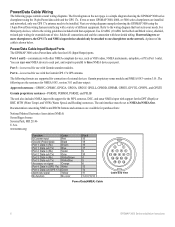
... one NMEA device to each port, and output in (GPS 17x) White Port 4: Data out (GPS 17x) Green Alarm low signal Yellow No function No color Pin # 15 18 16 17 9 10 4 5...Marine Electronics Association (NMEA) Seven Riggs Avenue Severna Park, MD 21146 U.S.A. Port 3-is shown below. A pinout of external devices: Garmin proprietary sonar module and NMEA 0183 version 3.01. You can input one chartplotter... on the network. Next are available for connection of the cable is reserved for use with the Garmin GPS 17x GPS antenna. Power/Data Cable Input/Output Ports The GPSMAP ...
... one NMEA device to each port, and output in (GPS 17x) White Port 4: Data out (GPS 17x) Green Alarm low signal Yellow No function No color Pin # 15 18 16 17 9 10 4 5...Marine Electronics Association (NMEA) Seven Riggs Avenue Severna Park, MD 21146 U.S.A. Port 3-is shown below. A pinout of external devices: Garmin proprietary sonar module and NMEA 0183 version 3.01. You can input one chartplotter... on the network. Next are available for connection of the cable is reserved for use with the Garmin GPS 17x GPS antenna. Power/Data Cable Input/Output Ports The GPSMAP ...
Installation Instructions
Page 7
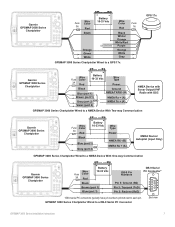
... Red 1A Unconnected Black White/ Orange White/Red Purple Orange White > Gray GPSMAP 3000 Series Chartplotter Wired to a GPS 17x GPS 17x > > > > > Garmin GPSMAP 3000 Series Chartplotter Wire Fuse Color 3A Red � � Battery 10-33 Vdc Wire Type Power Black > Blue (port 1) Brown (port 1) > Gray (port 2) OR Violet (port 2) Ground NMEA TX/RX- (B) ...
... Red 1A Unconnected Black White/ Orange White/Red Purple Orange White > Gray GPSMAP 3000 Series Chartplotter Wired to a GPS 17x GPS 17x > > > > > Garmin GPSMAP 3000 Series Chartplotter Wire Fuse Color 3A Red � � Battery 10-33 Vdc Wire Type Power Black > Blue (port 1) Brown (port 1) > Gray (port 2) OR Violet (port 2) Ground NMEA TX/RX- (B) ...
Installation Instructions
Page 8
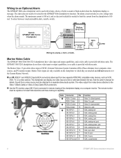
...available on a computer monitor. See the owner's manual for remote viewing of the chartplotter display on the chartplotter to which they are attached and will not transmit over the Garmin Marine Network. ➊ and ➋ VIDEO 1 and VIDEO 2 Inputs (RCA ...Color Fuse 3 A Red (power) Black (gnd) Yellow (alarm) Relay 100 ma max coil current Wiring to a lamp, a horn, or both , to sound or flash an alert when the chartplotter displays a message. The maximum current is 100 mA, and a relay (not included) is provided with those units. Horn Lamp Marine Video Cable The GPSMAP 3006/3206...
...available on a computer monitor. See the owner's manual for remote viewing of the chartplotter display on the chartplotter to which they are attached and will not transmit over the Garmin Marine Network. ➊ and ➋ VIDEO 1 and VIDEO 2 Inputs (RCA ...Color Fuse 3 A Red (power) Black (gnd) Yellow (alarm) Relay 100 ma max coil current Wiring to a lamp, a horn, or both , to sound or flash an alert when the chartplotter displays a message. The maximum current is 100 mA, and a relay (not included) is provided with those units. Horn Lamp Marine Video Cable The GPSMAP 3006/3206...
Owner's Manual
Page 120
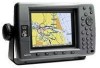
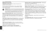
...offered by other Garmin Marine Network devices to the GPSMAP 3206/3210. GDL 30/GDL 30A Marine Weather XM Satelite Receiver-provides graphical and textual marine XM WX weather information that can be viewed through the GPSMAP 3206/3210 when ...Garmin products. Programmable Data Cards-blank data cards are also included on many data cards. Use of your GPSMAP 3206/3210 chartplotter. Download street-level map detail, points of ports, marinas, bridges, and navigational landmarks are available in the U.S.A. Full-color aerial photos of interest, business addresses and phone numbers, marine...
...offered by other Garmin Marine Network devices to the GPSMAP 3206/3210. GDL 30/GDL 30A Marine Weather XM Satelite Receiver-provides graphical and textual marine XM WX weather information that can be viewed through the GPSMAP 3206/3210 when ...Garmin products. Programmable Data Cards-blank data cards are also included on many data cards. Use of your GPSMAP 3206/3210 chartplotter. Download street-level map detail, points of ports, marinas, bridges, and navigational landmarks are available in the U.S.A. Full-color aerial photos of interest, business addresses and phone numbers, marine...


