Owner's Manual
Page 5
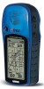
... defects, or reproductive harm. com/prop65. This Notice is being provided in the field of all times, and not become distracted by GARMIN is not warranted against collision damage or the consequences thereof. THIS PRODUCT IS INTENDED TO BE USED ONLY AS A TRAVEL AID AND MUST NOT ...the exclusion of safe driving practices. Do not mount the eTrex Legend in a place where the driver or passengers are driving. THIS PRODUCT SHOULD NOT BE USED AS AN AID TO DETERMINE GROUND PROXIMITY FOR AIRCRAFT NAVIGATION. Refer to secure the GPS unit so that can propel objects in their path toward...
... defects, or reproductive harm. com/prop65. This Notice is being provided in the field of all times, and not become distracted by GARMIN is not warranted against collision damage or the consequences thereof. THIS PRODUCT IS INTENDED TO BE USED ONLY AS A TRAVEL AID AND MUST NOT ...the exclusion of safe driving practices. Do not mount the eTrex Legend in a place where the driver or passengers are driving. THIS PRODUCT SHOULD NOT BE USED AS AN AID TO DETERMINE GROUND PROXIMITY FOR AIRCRAFT NAVIGATION. Refer to secure the GPS unit so that can propel objects in their path toward...
Owner's Manual
Page 6
...and accurate digital data is a precision electronic NAVigation AID (NAVAID), any NAVAID can be misused or misinterpreted and, therefore, become unsafe. GARMIN grants you a limited license to use a...GPS) is operated by the government of the United States, which we identify as required in product literature and copyright messages displayed to the consumer. You acknowledge that the structure, organiza- Although the eTrex Legend...the "Software") in binary executable form in GARMIN. Software License Agreement BY USING THE ETREX LEGEND, YOU AGREE TO BE BOUND BY THE TERMS AND CONDITIONS OF...
...and accurate digital data is a precision electronic NAVigation AID (NAVAID), any NAVAID can be misused or misinterpreted and, therefore, become unsafe. GARMIN grants you a limited license to use a...GPS) is operated by the government of the United States, which we identify as required in product literature and copyright messages displayed to the consumer. You acknowledge that the structure, organiza- Although the eTrex Legend...the "Software") in binary executable form in GARMIN. Software License Agreement BY USING THE ETREX LEGEND, YOU AGREE TO BE BOUND BY THE TERMS AND CONDITIONS OF...
Owner's Manual
Page 13
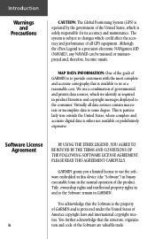
...'s instructions for you to see the display screen, you can last up to adjust the contrast. When using 'Battery Saver' or 'Use With GPS Off' mode when not navigating, Alkaline batter- The backlight remains on until the set to timeout 15 seconds after the last button press. (To reset the backlight timeout... for proper care and disposal of the unit. Rechargeable Alkaline, NiMH, NiCad or Lithium batteries may be used batteries. Getting Started Installing the Batteries The eTrex Legend operates on two "AA" batteries (not included), which are removed.
...'s instructions for you to see the display screen, you can last up to adjust the contrast. When using 'Battery Saver' or 'Use With GPS Off' mode when not navigating, Alkaline batter- The backlight remains on until the set to timeout 15 seconds after the last button press. (To reset the backlight timeout... for proper care and disposal of the unit. Rechargeable Alkaline, NiMH, NiCad or Lithium batteries may be used batteries. Getting Started Installing the Batteries The eTrex Legend operates on two "AA" batteries (not included), which are removed.
Owner's Manual
Page 15
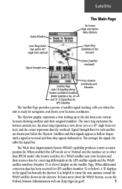
...Being Tracked and WAAS Enabled. Satellites and their assigned numbers. To learn more accurate position fix. When differential correction data has been received for each satellite are shown just below ), a 'D' displays in the skyview. The Wide Area Augmentation System (WAAS) capability produces... and the WAAS satellite numbers (Number 33 or above you when the unit is ready for navigation, and shows your location and then receives data for GPS Satellites Your location coordinates and Elevation The Satellite Page provides a picture of satellite signal tracking, ...
...Being Tracked and WAAS Enabled. Satellites and their assigned numbers. To learn more accurate position fix. When differential correction data has been received for each satellite are shown just below ), a 'D' displays in the skyview. The Wide Area Augmentation System (WAAS) capability produces... and the WAAS satellite numbers (Number 33 or above you when the unit is ready for navigation, and shows your location and then receives data for GPS Satellites Your location coordinates and Elevation The Satellite Page provides a picture of satellite signal tracking, ...
Owner's Manual
Page 16
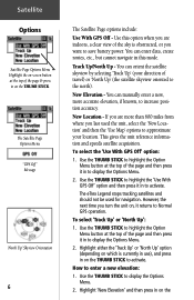
...miles from where you last used for navigation. However, the next time you are more accurate elevation, if known, to display the Options Menu. 2. Use the THUMB STICK to approximate your direction of the page & press in on , it in on the The eTrex Legend stops tracking satellites and should not be... press it returns to display the Options Menu. 2. How to display the Options Menu. 2. Highlight 'New Elevation' and then press in to Normal GPS operation. Use the THUMB STICK to highlight the Option Menu button at the top of the sky is currently in use), and press in to...
...miles from where you last used for navigation. However, the next time you are more accurate elevation, if known, to display the Options Menu. 2. Use the THUMB STICK to approximate your direction of the page & press in on , it in on the The eTrex Legend stops tracking satellites and should not be... press it returns to display the Options Menu. 2. How to display the Options Menu. 2. Highlight 'New Elevation' and then press in to Normal GPS operation. Use the THUMB STICK to highlight the Option Menu button at the top of the sky is currently in use), and press in to...
Owner's Manual
Page 17
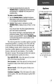
... will attempt to gather GPS signals.) Options 'Use Map' option helps to provide navigational guidance, so getting a clear view of miles (from where you want GPS off (for the "Poor Satellite Reception" message. 7 New Location - Restart Search - If you choose 'Auto' the eTrex Legend determines your location on ...moved hundreds of the sky is not (date provided). Select this option if you last used the unit). The eTrex Legend relies on the map and press it in to your location, otherwise the unit displays a "Poor Satellite Reception" message. Satellite 3.
... will attempt to gather GPS signals.) Options 'Use Map' option helps to provide navigational guidance, so getting a clear view of miles (from where you want GPS off (for the "Poor Satellite Reception" message. 7 New Location - Restart Search - If you choose 'Auto' the eTrex Legend determines your location on ...moved hundreds of the sky is not (date provided). Select this option if you last used the unit). The eTrex Legend relies on the map and press it in to your location, otherwise the unit displays a "Poor Satellite Reception" message. Satellite 3.
Owner's Manual
Page 20
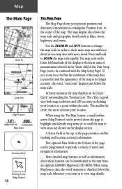
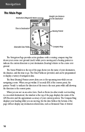
... A Status Field at the bottom of the page can be downloaded to the unit from an optional GARMIN MapSource CD-ROM. Two optional Data fields at the top of travel and navigation information. If you zoom in to view map details. The map scale in the lower left hand side... a triangular 'Position Icon', in the center of the Unit Setup Page (not to be confused with more accurate your location. The eTrex Legend uses both map resolution and GPS accuracy in defining your location to ZOOM the map scale rapidly. More detailed map features as well as lakes, rivers, highways...
... A Status Field at the bottom of the page can be downloaded to the unit from an optional GARMIN MapSource CD-ROM. Two optional Data fields at the top of travel and navigation information. If you zoom in to view map details. The map scale in the lower left hand side... a triangular 'Position Icon', in the center of the Unit Setup Page (not to be confused with more accurate your location. The eTrex Legend uses both map resolution and GPS accuracy in defining your location to ZOOM the map scale rapidly. More detailed map features as well as lakes, rivers, highways...
Owner's Manual
Page 23
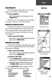
...Hide/Show Data Fields The 'Hide Data Fields/Show Data Fields' option allows you to view GPS navigation data in the data field. Use the THUMB STICK to highlight the data fi... window at the top of the page that lists the status of satellite tracking and accuracy of GPS positioning. To hide or show Data Fields: Select 'Hide' or 'Show' from the option list.... To program a data field: 1. Map Stop Navigation The 'Stop Navigation' option allows you to page up or down. To stop navigation: Select 'Stop Navigation' and then press in progress. Use the ZOOM IN/OUT...
...Hide/Show Data Fields The 'Hide Data Fields/Show Data Fields' option allows you to view GPS navigation data in the data field. Use the THUMB STICK to highlight the data fi... window at the top of the page that lists the status of satellite tracking and accuracy of GPS positioning. To hide or show Data Fields: Select 'Hide' or 'Show' from the option list.... To program a data field: 1. Map Stop Navigation The 'Stop Navigation' option allows you to page up or down. To stop navigation: Select 'Stop Navigation' and then press in progress. Use the ZOOM IN/OUT...
Owner's Manual
Page 26
...Goto, Track or Route (in other words: not traveling to a recorded destination), the window at the top of the page displays the status of the GPS Receiver and the approximate accuracy of the turn to the next point while still showing the direction to indicate the direction of your destination (bearing) relative...you to the course over ground (track) while you're moving , but the data fields at the top of the page shows you are navigating a route. When you are provided, and can be programmed to go. The Compass Ring displays your heading while you get within 15 seconds ETA ...
...Goto, Track or Route (in other words: not traveling to a recorded destination), the window at the top of the page displays the status of the GPS Receiver and the approximate accuracy of the turn to the next point while still showing the direction to indicate the direction of your destination (bearing) relative...you to the course over ground (track) while you're moving , but the data fields at the top of the page shows you are navigating a route. When you are provided, and can be programmed to go. The Compass Ring displays your heading while you get within 15 seconds ETA ...
Owner's Manual
Page 57
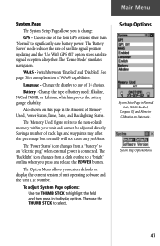
... "electric plug" when external power is the Amount of Memory Used, Power Status, Time, Date, and Backlighting Status. The 'Demo Mode' simulates navigation. Switch between 'Enabled' and 'Disabled'. The 'Backlight' icon changes from a "battery" to display options. Choose one of WAAS capabilities. See ...Page The System Setup Page allows you restore defaults or display the current version of satellite signal position updating and the 'Use With GPS Off' option stops satellite signal reception altogether. Language - Battery - Change the type of 14 choices. Saving a number of ...
... "electric plug" when external power is the Amount of Memory Used, Power Status, Time, Date, and Backlighting Status. The 'Demo Mode' simulates navigation. Switch between 'Enabled' and 'Disabled'. The 'Backlight' icon changes from a "battery" to display options. Choose one of WAAS capabilities. See ...Page The System Setup Page allows you restore defaults or display the current version of satellite signal position updating and the 'Use With GPS Off' option stops satellite signal reception altogether. Language - Battery - Change the type of 14 choices. Saving a number of ...
Owner's Manual
Page 64
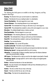
... time of day you will arrive at which the sun sets on this day. The lat/lon of point defined on the Map, Navigation, and Trip Computer Main Pages. The maximum second-by -second position readings. Your rate of travel ). The time at your current location to... remaining distance to arrive at which the sun rises on your route. The time for both moving and stopped speeds since last reset. Your current GPS position. Course - Off Course - The distance left or right you will reach your starting location to the next destination. Current Destination - Sunrise - ...
... time of day you will arrive at which the sun sets on this day. The lat/lon of point defined on the Map, Navigation, and Trip Computer Main Pages. The maximum second-by -second position readings. Your rate of travel ). The time at your current location to... remaining distance to arrive at which the sun rises on your route. The time for both moving and stopped speeds since last reset. Your current GPS position. Course - Off Course - The distance left or right you will reach your starting location to the next destination. Current Destination - Sunrise - ...
Owner's Manual
Page 70
... of Interest 31 Waypoint 28 FIND button 2, 27 Find Menu 23, 27 G GARMIN DGPS 46 Limited Warranty vi, vii Proprietary Sentences 58 Getting Started 1 Glide Ratio 21 Global Positioning System (GPS 3, 5, 47, 52, 58, iii Goto Cancelling (Stop Navigation) 11, 13, 34, 40 Functions 8, 12, 29, 34 Line 14 H... Handlebar Mounting Bracket 53 Heading 14, 18, 21, 54 Heading Page 45 Hide Data Fields 11, 13 Hide Navigation Status 11, 13 How To access...
... of Interest 31 Waypoint 28 FIND button 2, 27 Find Menu 23, 27 G GARMIN DGPS 46 Limited Warranty vi, vii Proprietary Sentences 58 Getting Started 1 Glide Ratio 21 Global Positioning System (GPS 3, 5, 47, 52, 58, iii Goto Cancelling (Stop Navigation) 11, 13, 34, 40 Functions 8, 12, 29, 34 Line 14 H... Handlebar Mounting Bracket 53 Heading 14, 18, 21, 54 Heading Page 45 Hide Data Fields 11, 13 Hide Navigation Status 11, 13 How To access...
Owner's Manual
Page 73
...14 Setup Map options 15 Setup Menu 43 Setup Page 22, 23 Setup the Navigation Page 18 Set course 16-20 Show Data Fields 11, 13 Navigation Status 13 Nav Status 11 Software License Agreement iv Software Version (operating 23, ...;cations 52 Speed Data Field 14, 18, 21, 54 Maximum 54 Moving Avg. 54 Overall Avg. 54 Units 44 Stop Navigation 11, 13, 17 Storage v Street Label 15 Sunrise 14, 18, 21, 54 Sunrise At Point 40 Sunset 14, 18...21, 55 Total 14, 18, 21, 55 Troubleshooting 57 Turn 14, 18, 21, 55 Turning GPS Receiver "off 6 U Units of Measure 10, 23, 43, 44 Units Page 44 Unit I.D.
...14 Setup Map options 15 Setup Menu 43 Setup Page 22, 23 Setup the Navigation Page 18 Set course 16-20 Show Data Fields 11, 13 Navigation Status 13 Nav Status 11 Software License Agreement iv Software Version (operating 23, ...;cations 52 Speed Data Field 14, 18, 21, 54 Maximum 54 Moving Avg. 54 Overall Avg. 54 Units 44 Stop Navigation 11, 13, 17 Storage v Street Label 15 Sunrise 14, 18, 21, 54 Sunrise At Point 40 Sunset 14, 18...21, 55 Total 14, 18, 21, 55 Troubleshooting 57 Turn 14, 18, 21, 55 Turning GPS Receiver "off 6 U Units of Measure 10, 23, 43, 44 Units Page 44 Unit I.D.
Quick Reference Guide
Page 1
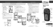
... the THUMB STICK to highlight the waypoint and then press it in Taiwan LEGEND QUICK START GUIDE Internal GPS Antenna External Power/Data Connector (on back) Thumb Stick Page Button Power...Map Page and the Navigation page to get a more minutes and then stop navigating, highlight the Options Menu button on a Goto Map Page Options Menu © Copyright 2005 GARMIN Ltd. C Printed ...Icon and a straight dark line leading to the waypoint. Basic Navigation Basic Navigation Starting to Navigate Basic navigation with your eTrex Legend requires only three steps: mark, move to the Map Page ...
... the THUMB STICK to highlight the waypoint and then press it in Taiwan LEGEND QUICK START GUIDE Internal GPS Antenna External Power/Data Connector (on back) Thumb Stick Page Button Power...Map Page and the Navigation page to get a more minutes and then stop navigating, highlight the Options Menu button on a Goto Map Page Options Menu © Copyright 2005 GARMIN Ltd. C Printed ...Icon and a straight dark line leading to the waypoint. Basic Navigation Basic Navigation Starting to Navigate Basic navigation with your eTrex Legend requires only three steps: mark, move to the Map Page ...


