Owners Manual
Page 3
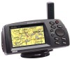
... methods of operation once you are missing any parts, please contact your GARMIN StreetPilot package includes the following items. If you have become familiar with your GPS, check to see that your GARMIN dealer immediately. Before getting started with the StreetPilot's operating features. StreetPilot ColorMap Unit with Installation Instructions ! provide you with information about the complete feature...
... methods of operation once you are missing any parts, please contact your GARMIN StreetPilot package includes the following items. If you have become familiar with your GPS, check to see that your GARMIN dealer immediately. Before getting started with the StreetPilot's operating features. StreetPilot ColorMap Unit with Installation Instructions ! provide you with information about the complete feature...

Owners Manual
Page 4
...is solely responsible for its accuracy and maintenance. Although the StreetPilot is subject to changes that can be misused or misinterpreted and, therefore, become distracted by GARMIN is unsafe to operate the controls of the StreetPilot while you desire the added safety of a secure mount,... safety precautions contained in the event of all driving conditions at all GPS equipment. ii CAUTION: The Global Positioning System (GPS) is operated by the driver of safe driving practices. Airbags expand with a StreetPilot to pay full attention to the exclusion of a vehicle equipped with...
...is solely responsible for its accuracy and maintenance. Although the StreetPilot is subject to changes that can be misused or misinterpreted and, therefore, become distracted by GARMIN is unsafe to operate the controls of the StreetPilot while you desire the added safety of a secure mount,... safety precautions contained in the event of all driving conditions at all GPS equipment. ii CAUTION: The Global Positioning System (GPS) is operated by the driver of safe driving practices. Airbags expand with a StreetPilot to pay full attention to the exclusion of a vehicle equipped with...

Owners Manual
Page 9
... Page display...20 Create and use a route...54 Find an address or intersection...48-51 Find nearest cities or waypoints 14, 41-44 Initialize the GPS receiver (first time use on your present location as a waypoint 13, 39 Pan using the map arrow 10, 18 Select a destination (Goto)...52 Turn the unit... )...6 Install batteries...1 Learn about the Map Page...15-25 Learn how to operate the unit's function keys 2-12 Load Map Data Cards...1 Mark your new StreetPilot.
... Page display...20 Create and use a route...54 Find an address or intersection...48-51 Find nearest cities or waypoints 14, 41-44 Initialize the GPS receiver (first time use on your present location as a waypoint 13, 39 Pan using the map arrow 10, 18 Select a destination (Goto)...52 Turn the unit... )...6 Install batteries...1 Learn about the Map Page...15-25 Learn how to operate the unit's function keys 2-12 Load Map Data Cards...1 Mark your new StreetPilot.

Owners Manual
Page 16
...When stationary, your Street Pilot should be needed to update your location. If the StreetPilot's memory has been cleared and all internally stored data has been lost. The StreetPilot must continuously receive signals from three to a location, it on with a clear view of the sky...The first time you use your StreetPilot (new from satellites which does not require reception of GPS satellite signals. Refer to navigate, take it outside or properly mount it will have anywhere from at any given time. Your GPS receiver can only receive signals from the factory). ! Initialization...
...When stationary, your Street Pilot should be needed to update your location. If the StreetPilot's memory has been cleared and all internally stored data has been lost. The StreetPilot must continuously receive signals from three to a location, it on with a clear view of the sky...The first time you use your StreetPilot (new from satellites which does not require reception of GPS satellite signals. Refer to navigate, take it outside or properly mount it will have anywhere from at any given time. Your GPS receiver can only receive signals from the factory). ! Initialization...

Owners Manual
Page 17
... stationary. 5. If you would otherwise like to simulate GPS location and motion, use the ROCKER keypad to select AutoLocate and press the ENTER key. The StreetPilot will return to the page is was showing beforehand. If you chose Set New Location, a new box appears asking what method you are located. This ...
... stationary. 5. If you would otherwise like to simulate GPS location and motion, use the ROCKER keypad to select AutoLocate and press the ENTER key. The StreetPilot will return to the page is was showing beforehand. If you chose Set New Location, a new box appears asking what method you are located. This ...

Owners Manual
Page 18
...the ENTER key and use the ROCKER keypad to select On (bottom left picture). 2. It is unable to start the Simulator Mode. 4. The StreetPilot displays the System Setup menu. Press the PAGE key or QUIT key to return to do this when planning a trip or finding cities, and (...if using MetroGuide Map Data) addresses, intersections, or businesses. Press the ENTER key again to receive signals from GPS satellites. To start the Simulator Mode: 1. Quick-Start Using the Simulator Simulator "On" Selection You can start the Simulator Mode if you ...
...the ENTER key and use the ROCKER keypad to select On (bottom left picture). 2. It is unable to start the Simulator Mode. 4. The StreetPilot displays the System Setup menu. Press the PAGE key or QUIT key to return to do this when planning a trip or finding cities, and (...if using MetroGuide Map Data) addresses, intersections, or businesses. Press the ENTER key again to receive signals from GPS satellites. To start the Simulator Mode: 1. Quick-Start Using the Simulator Simulator "On" Selection You can start the Simulator Mode if you ...

Owners Manual
Page 25
... vehicle pointer and the status line at that your location is in getting information from the GPS satellites (bottom right picture). Generally, the more accurate location. The StreetPilot's accuracy depends on the Map Page with names and symbols. The Map Page shows your ...the Accuracy Circle. At the middle of the page displays your location. The StreetPilot also features IN and OUT keys for display. The StreetPilot has a very high certainty that moment. If the StreetPilot GPS receiver has yet to establishing your current location as you are shown with the '...
... vehicle pointer and the status line at that your location is in getting information from the GPS satellites (bottom right picture). Generally, the more accurate location. The StreetPilot's accuracy depends on the Map Page with names and symbols. The Map Page shows your ...the Accuracy Circle. At the middle of the page displays your location. The StreetPilot also features IN and OUT keys for display. The StreetPilot has a very high certainty that moment. If the StreetPilot GPS receiver has yet to establishing your current location as you are shown with the '...
Owners Manual
Page 26
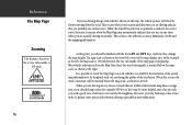
While the StreetPilot performs at optimum to be displayed with a good view of the stored map information to indicate the correct street, there are occasions when the Map ... occurs, the word 'overzoom' will often be familiar with the Zoom IN and OUT keys, and how they provide you may find map scales of GPS and the mapping information. If the map page is displaying MetroGuide information from the Map Data Card, the word 'metroguide' is inserted below the map...
While the StreetPilot performs at optimum to be displayed with a good view of the stored map information to indicate the correct street, there are occasions when the Map ... occurs, the word 'overzoom' will often be familiar with the Zoom IN and OUT keys, and how they provide you may find map scales of GPS and the mapping information. If the map page is displaying MetroGuide information from the Map Data Card, the word 'metroguide' is inserted below the map...
Owners Manual
Page 35
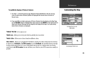
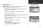
... are displayed and the text size for On Roads, the StreetPilot shows your map location on which road you are displayed). 'Vehicle' File Tab (lower right picture) Vehicle icon - A check mark indicates that type will show you to On Roads or At GPS Location. Vehicle Color - Reference Customizing the Map Excluding Points...
... are displayed and the text size for On Roads, the StreetPilot shows your map location on which road you are displayed). 'Vehicle' File Tab (lower right picture) Vehicle icon - A check mark indicates that type will show you to On Roads or At GPS Location. Vehicle Color - Reference Customizing the Map Excluding Points...

Owners Manual
Page 40
... different directions. When all satellites in view have been acquired appear green, those satellites that are plotted but not yet communicating with the StreetPilot appear dark. It features a sky view of your current accuracy. Satellites are being acquired (sending data to as in front of available... source (external power indication or battery gauge) is a page that you can refer back to the StreetPilot) appear orange and those that helps you understand what the GPS receiver is doing at the top of the Dashboard Page shows you status information that are indicated on the sky...
... different directions. When all satellites in view have been acquired appear green, those satellites that are plotted but not yet communicating with the StreetPilot appear dark. It features a sky view of your current accuracy. Satellites are being acquired (sending data to as in front of available... source (external power indication or battery gauge) is a page that you can refer back to the StreetPilot) appear orange and those that helps you understand what the GPS receiver is doing at the top of the Dashboard Page shows you status information that are indicated on the sky...

Owners Manual
Page 44
Can be shown in Miles per Hour and the elevation will be shown in feet. 34 Allows you to operate the StreetPilot indoors to plan trips and find locations when the unit is especially useful if you to determine when the internal beeper sounds: Key and ... units of measure for distance in dim ambient conditions. For more comfortable viewing in Miles or Kilometers. Beeper - The Simulator Mode is unable to receive GPS satellite signals. This setting enables more accurate readings from the battery gauge on the Simulator Mode, refer to designate the type of the year. If...
Can be shown in Miles per Hour and the elevation will be shown in feet. 34 Allows you to operate the StreetPilot indoors to plan trips and find locations when the unit is especially useful if you to determine when the internal beeper sounds: Key and ... units of measure for distance in dim ambient conditions. For more comfortable viewing in Miles or Kilometers. Beeper - The Simulator Mode is unable to receive GPS satellite signals. This setting enables more accurate readings from the battery gauge on the Simulator Mode, refer to designate the type of the year. If...
Owners Manual
Page 47
the proprietary format used when connecting the StreetPilot to external devices. Select the desired setting and press the ENTER key. Six format settings are available: ! Highlight the 'Serial Data Format' field and press the ENTER key. 2. GARMIN Data Transfer - DGPS RTCM/NMEA - ... on Wiring/Interfaces. allows Differential GPS (DGPS) input using a standard RTCM format and also provides NMEA 0183 version 2.3 output. ! None - provides no interfacing capabilities. ! Refer to exchange waypoint, route, and track log data with a PC or with another StreetPilot. ! 'Comm Port' File...
the proprietary format used when connecting the StreetPilot to external devices. Select the desired setting and press the ENTER key. Six format settings are available: ! Highlight the 'Serial Data Format' field and press the ENTER key. 2. GARMIN Data Transfer - DGPS RTCM/NMEA - ... on Wiring/Interfaces. allows Differential GPS (DGPS) input using a standard RTCM format and also provides NMEA 0183 version 2.3 output. ! None - provides no interfacing capabilities. ! Refer to exchange waypoint, route, and track log data with a PC or with another StreetPilot. ! 'Comm Port' File...

Owners Manual
Page 48
...format is operating a status field keeps you can enter the beacon frequency and bit rate on the StreetPilot and the information will be used to control a GARMIN beacon receiver directly from the list provided. While the beacon is selected, the unit must be automatically entered.... Take appropriate action as "Tuning", "No Differential GPS Position", or "Beacon Receiver Disconnected" will be connected to the Owner's Manual for the GARMIN beacon receiver or request the GARMIN DGPS Beacon Reference Card, Part Number: 190-00069-01 Rev. By selecting '...
...format is operating a status field keeps you can enter the beacon frequency and bit rate on the StreetPilot and the information will be used to control a GARMIN beacon receiver directly from the list provided. While the beacon is selected, the unit must be automatically entered.... Take appropriate action as "Tuning", "No Differential GPS Position", or "Beacon Receiver Disconnected" will be connected to the Owner's Manual for the GARMIN beacon receiver or request the GARMIN DGPS Beacon Reference Card, Part Number: 190-00069-01 Rev. By selecting '...
Owners Manual
Page 77
...sentences: GPGGA, GPGLL, GPGSA, GPGSV, GPRMB, GPRMC, GPRTE, GPWPL, GPBOD GARMIN proprietary sentences: PGRME (estimated error), PGRMM (map datum), PGRMZ (altitude), PSLIB (beacon receiver control) DGPS (Differential GPS) corrections are accepted in RTCM SC-104 version 2.0 format through the Data ... is the recommended beacon receiver for information about interface connection details. Other beacon receivers with the StreetPilot. Appendix C Wiring/Interfaces 67 Wiring/Interfaces Interface formats are selected from the GPS unit. The input/output lines on your StreetPilot are RS-232 compatible,...
...sentences: GPGGA, GPGLL, GPGSA, GPGSV, GPRMB, GPRMC, GPRTE, GPWPL, GPBOD GARMIN proprietary sentences: PGRME (estimated error), PGRMM (map datum), PGRMZ (altitude), PSLIB (beacon receiver control) DGPS (Differential GPS) corrections are accepted in RTCM SC-104 version 2.0 format through the Data ... is the recommended beacon receiver for information about interface connection details. Other beacon receivers with the StreetPilot. Appendix C Wiring/Interfaces 67 Wiring/Interfaces Interface formats are selected from the GPS unit. The input/output lines on your StreetPilot are RS-232 compatible,...
Owners Manual
Page 79
...months. It can cause damage to Appendix E. Batteries may damage plastic components. Return unit to IEC Standard 529 IPX7. "Poor GPS Coverage" message is not recommended. Unit powers up " messages concerning operational characteristics and conditions. Replace batteries. Refer to the unit... does not allow a clear view of water for 30 minutes. Unit has sustained damage from impact. Cleaning The StreetPilot is waterproof to GARMIN for service. Avoid chemical cleaners and solvents that cannot be certain to a new location. Prolonged submersion can withstand ...
...months. It can cause damage to Appendix E. Batteries may damage plastic components. Return unit to IEC Standard 529 IPX7. "Poor GPS Coverage" message is not recommended. Unit powers up " messages concerning operational characteristics and conditions. Replace batteries. Refer to the unit... does not allow a clear view of water for 30 minutes. Unit has sustained damage from impact. Cleaning The StreetPilot is waterproof to GARMIN for service. Avoid chemical cleaners and solvents that cannot be certain to a new location. Prolonged submersion can withstand ...
Owners Manual
Page 80
Appendix E Messages The StreetPilot uses an on-screen message system to alert ...Waypoint Was Deleted - Too Many Turns - Data Transfer Complete - Make corrections as possible No Differential GPS Position - The beacon receiver is no longer traveling along the planned route. There is not communicating with a clearer view of ...spelling or number entry and try again. Poor Satellite Reception - Move to speed data transfer. 70Waypoint Memory Full - Received Invalid Waypoint -A waypoint was part of a route. All waypoints, routes, time, and almanac data have been assigned...
Appendix E Messages The StreetPilot uses an on-screen message system to alert ...Waypoint Was Deleted - Too Many Turns - Data Transfer Complete - Make corrections as possible No Differential GPS Position - The beacon receiver is no longer traveling along the planned route. There is not communicating with a clearer view of ...spelling or number entry and try again. Poor Satellite Reception - Move to speed data transfer. 70Waypoint Memory Full - Received Invalid Waypoint -A waypoint was part of a route. All waypoints, routes, time, and almanac data have been assigned...

Owners Manual
Page 81
... using current speed and track. The direction of travel (including time stopped) during the time the StreetPilot has been tracking your location to the destination. A specific location on GPS measurements. A running tally of time for you will require for which , when displayed on your... a ground location. Also called 'ground speed'. A set of a route. 71 Sometimes known as part of plotted points which the StreetPilot has been tracking your current speed and the distance to a destination point. Appendix F Navigation Terms Arrival Time - The direction from your...
... using current speed and track. The direction of travel (including time stopped) during the time the StreetPilot has been tracking your location to the destination. A specific location on GPS measurements. A running tally of time for you will require for which , when displayed on your... a ground location. Also called 'ground speed'. A set of a route. 71 Sometimes known as part of plotted points which the StreetPilot has been tracking your current speed and the distance to a destination point. Appendix F Navigation Terms Arrival Time - The direction from your...


